
Mountain saddles
Park geography
Technical terrain analysis featuring peak elevations, landscape classifications, and administrative regions
Comprehensive Geographic Profile and Mapped Boundaries of Alps of Albania National Park
Examine the detailed geographic layout of Alps of Albania National Park, which covers 828.45 square kilometers across Shkodër and Kukës counties. This structured profile includes elevation records peaking at 2694 meters, mapped karst and glacial terrain, and a comprehensive inventory of contained natural features such as Maja e Jezercës and multiple high-altitude mountain passes.
Albania's largest protected wilderness in the Accursed Mountains
Alps of Albania National Park
Alps of Albania National Park is the largest national park in Albania, established in January 2022 through the amalgamation of three protected areas: Theth National Park, Valbona Valley National Park, and Gashi Nature Reserve. The park encompasses the spectacular Albanian Alps, also known as the Accursed Mountains, a mountain range that forms part of the Dinaric Alps and contains most of Albania's peaks exceeding 2,000 meters. The park's terrain is dominated by dramatic limestone and dolomite formations with extensive karst features including deep canyons, caves, and glacial valleys. This remote and largely untouched wilderness protects a remarkable diversity of ecosystems spanning from oak-dominated forests through beech and fir zones to alpine meadows, making it one of the most ecologically significant protected areas in the Balkans.
- Location
- Albania
- Park type
- National park
- Established
- 2022
- Area
- 828.4 km²
- Highest point
- 2,694 m
Location overview
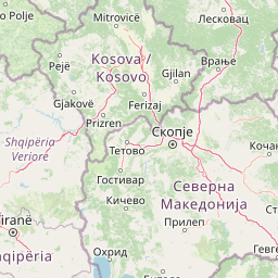
Mapped regional placement and transboundary status in Albania
Alps of Albania National Park Geography and Location Profile
Alps of Albania National Park is located within Shkodër County and Kukës County in Albania. Documented geographic records highlight the transboundary status of the protected territory.
- Countries
- Albania
- Regions
- Kukës County, Shkodër County
- Primary location
- Albania
- Geographic setting
- Transboundary · Inland
Boundary and coordinates
Mapping the 828 square kilometer terrain envelope and coordinates
Alps of Albania National Park Boundary Map and Spatial Limits
Interactive boundary outlines map the spatial context and geographic shape of the protected territory. Accompanying dataset records present estimated surface area, coordinate spans, and center points.
- Boundary area
- 774.4 km²
- Boundary perimeter
- 191.2 km
- Northernmost point
- 42.6612° N
- Southernmost point
- 42.2936° N
- Easternmost point
- 20.0626° E
- Westernmost point
- 19.5229° E
- Geographic centre
- 42.45° N, 19.7278° E
- North–south span
- 40.8 km
- East–west span
- 44.4 km
Elevation and terrain
Explore recorded mountain peaks, waterfalls, and internal natural features.
Alps of Albania National Park Terrain and Elevation Range Geography
Review the recorded elevation summary and mountain relief metrics for Alps of Albania National Park. Examine the structured cards detailing named natural features and spatial relationships within the protected area.
- Maximum elevation
- 2,694 m
- Highest point
- 2,694 m
Selected named natural features
Streams
Šeu i Mulive
Waterfalls
Rrogam Waterfall
Streams
Lumi i Cemit
Peaks
Ćafa Saharce / Qafa e Saharcës (B7/I)
1,974 m
Peaks
Maja Pishtërës
2,033 m
Environmental setting
Temperate mountain relief, major water bodies, and forest habitat profiles
Alps of Albania National Park Environmental Classifications and Physical Setting
Recorded landscape features and habitat types serve as interpretive categories for the physical setting of Alps of Albania National Park. Connected atlas destinations link these stored environmental classifications directly to related protected areas.
- Relief
- Mountain
- Climate
- Temperate
- Water
- Major water bodies
- Forest cover
- Mostly forested
Landscape features
Mountains · Valleys · Cliffs · Canyon · Forest · Glacier · Karst · Lakes · Rivers · Waterfalls · Cave
Habitat types
Temperate broadleaf forest · Montane forest · Alpine meadow · Grassland · Riverine habitat · Lacustrine habitat · Karst habitat
Park atlas
Compare connected protected landscapes and high-altitude ecosystems across the broader Dinaric Alps region.
Explore Nearby National Parks and Protected Areas Surrounding Alps of Albania
After exploring Alps of Albania National Park, browse other national parks and protected areas across the Dinaric Alps and surrounding Balkan region. Comparing these diverse conservation landscapes provides valuable geographic context and highlights the varied mountain, forest, and karst ecosystems under protection.

Protected areaAlbania
Mapped location lies within the park boundary#1 closest
Northeast

Accursed Mountains: Geographic Analysis of Albania High Alpine Protected Terrain
Rugged karstic relief and glacial mountain landscapes.
Discover the Accursed Mountains, a formidable high-mountain range in northern Albania known for its sheer limestone cliffs and profound glacial sculpting. This protected area provides a critical habitat for relict flora and fauna while maintaining one of the most intense relief profiles in the Balkans. Examine the mapped canyons, alpine cirques, and jagged ridges that shape this landmark range.
- Relief
- Mountain
- Climate
- Alpine
- Access
- Moderate access
- Scope
- Terrestrial
Nature reserveKukës County
About 4.7 km away#2 closest
East
Gashi Valley Nature Reserve: A Geographic Profile of Alpine Albania
Glacial terrain and protected primeval forests in Kukës County
Gashi Valley represents a vital nature reserve and protected alpine landscape in the Albanian Alps. Characterized by its glacial history, the area contains rugged ridges, morainic lakes, and primeval beech forests that serve as a crucial benchmark for European broadleaf ecosystems. This site offers deep insight into the complex geology and ecological significance of the northeastern mountain regions in Albania.
- Area
- 30 km²
- IUCN
- Ia
- Relief
- Mountain
- Climate
- Alpine
National parkKosovo
8 km away#3 closest
Northeast

Bjeshkët e Nemuna National Park: Kosovo's Largest Alpine Protected Landscape
Explore dramatic mountains, glacial lakes, and diverse ecosystems.
Delve into the protected geography of Bjeshkët e Nemuna National Park, Kosovo's expansive national park located in the Accursed Mountains. This atlas entry details its significant alpine terrain, from dense forests to high-altitude meadows, and highlights the presence of glacial lakes like Liqenat. Understand its role as a vital conservation corridor and a key component of the Balkan's natural heritage.
- Area
- 630.28 km²
- Established
- 2012
- IUCN
- II
- Relief
- Mountain
National parkKolašin Municipality
20 km away#4 closest
North

Biogradska Gora National Park: Mountain Geography and Old-Growth Forest Map Exploration
Protected wilderness in the Bjelasica mountain range of central Montenegro
Biogradska Gora serves as a vital protected area in Montenegro, characterized by its sprawling Bjelasica ridges, six distinct glacial lakes, and primeval beech ecosystems. The park terrain offers an expansive look at Balkan high-mountain geography, ranging from deep forested valleys to alpine meadows and peaks exceeding 2,000 meters in elevation.
- Area
- 54 km²
- Established
- 1952
- IUCN
- II
- Relief
- Mountain
National parkMontenegro
About 25 km away#5 closest
Southwest
Lake Skadar National Park: An Atlas Overview of Montenegro's Largest Freshwater Wetland
Karst Terrain and Transboundary Protected Landscapes
Lake Skadar stands as a monumental geographic feature in Montenegro, serving as the largest lake in Southern Europe. This national park protects a diverse ecosystem ranging from submerged karst springs to expansive seasonal marshes. Its status as a transboundary system offers insights into Mediterranean hydrology and endemic freshwater biodiversity within the unique Balkan karst basin.
- Area
- 450 km²
- Established
- 1983
- Relief
- Lowland
- Climate
- Mediterranean
Protected areaMontenegro
About 26 km away#6 closest
West
Cijevna Protected Area: Mapping the River Canyon and Balkan Highlands Geography
An alpine river system spanning the Montenegro and Albania border
The Cijevna represents a striking natural corridor carved into the Prokletije mountains. This protected landscape is defined by its deep V-shaped valleys, high-altitude gorges, and seasonal discharge patterns that sustain important freshwater biodiversity across the Balkan highlands.
Nature reserveShkodër District
About 27 km away#7 closest
Southwest
Lake Shkodër Nature Reserve: Mapping Protected Wetland and Riverine Geography in Albania
A critical Balkan freshwater protected area.
The Lake Shkodër Nature Reserve serves as a foundational protected landscape in northern Albania, encompassing the extensive shoreline and riverine floodplains of Lake Skadar. This geographic entity showcases a transition from fertile lowlands to mountainous ridges, offering a detailed look at how hydrologic processes and alpine proximity define Balkan wetland habitats.
- Area
- 265.35 km²
- Established
- 2005
- IUCN
- IV
- Relief
- Lowland
National parkMontenegro
About 28 km away#8 closest
North
Biogradska Gora National Park: Ancient Beech Forest and Protected Landscape Exploration
Discover Montenegro's oldest national park with mapped terrain and regional geography.
Biogradska Gora National Park represents a critical protected area in Montenegro, celebrated for its exceptionally well-preserved ancient beech forest. This national park features a heterogeneous terrain of rolling hills and river valleys that create a unique natural setting. The dense, old-growth canopy offers an immersive experience of a primeval forest ecosystem, providing significant value for understanding Balkan nature and protected forest dynamics. Explore the mapped boundaries and discover the distinct landscape character that defines this remarkable natural reserve.
- IUCN
- II
MoriAtlas Explorer
Continue Mapping the Alps of Albania National Park's Geographic Features
Delve deeper into the structured atlas data for the Alps of Albania National Park, a significant protected landscape within the Accursed Mountains. Understand its unique terrain, from glacial valleys to extensive karst formations, and how it fits into the broader regional geography. This exploration helps contextualize the park's protected wilderness and its position within the Dinaric Alps system.
Browse next
Global natural geography
Explore related park routes
Explore MoriAtlas Global ParksBrowse All MoriAtlas ParksGlobal Park Map DiscoveryMoriAtlas: Browse All CountriesBrowse All MoriAtlas ContinentsNational Park Environment AtlasGrand Canyon National Park AtlasYellowstone National Park AtlasYosemite National Park Atlas and GeographySerengeti National Park AtlasGalápagos National Park Protected LandscapeBanff National Park Geography and AtlasKruger National Park Atlas EntryUluṟu-Kata Tjuṯa National Park AtlasExplore Uluru-Kata Tjuta National Park GeographyPlitvice Lakes National Park AtlasFiordland National Park Protected LandscapeGreat Smoky Mountains National Park AtlasAfghanistan National Parks and Protected AreasAlbania National Parks and Protected AreasAlgeria National Parks and Protected AreasAmerican Samoa National Parks and Protected AreasAndorra National Parks and Protected AreasAngola National Parks and Protected AreasAntarctica National Parks and Protected AreasAntigua and Barbuda Park List