

Mori Atlas logo
Nature reserveAnna's Reservoir Conservation Reserve

Examining the arid interior landscape and critical water source within Aileron Station

Anna's Reservoir Conservation Reserve: Mapping a Protected Nature Reserve in the Northern Territory

Anna's Reservoir Conservation Reserve occupies a unique position in the Northern Territory of Australia as a protected site focused on a natural rock-hole. This conservation area preserves 85 hectares of arid terrain, serving as an important historical landmark and water catchment point within the broader context of central Australia's pastoral landscapes and inland exploration history.

Northern Territoryrock-holeAileron StationAnmatyerre countryIUCN Category IIIarid interior

Anna's Reservoir Conservation Reserve

Nature reserve

Park overview

Structured park overview, official facts, and landscape profile for Anna's Reservoir Conservation Reserve

Anna's Reservoir Conservation Reserve park facts, protected area profile, and essential visitor context

Review the core facts for Anna's Reservoir Conservation Reserve, including designation, size, terrain, visitor scale, habitats, and operating context in one park-focused overview.

About Anna's Reservoir Conservation Reserve

Anna's Reservoir Conservation Reserve is a small protected area in the Northern Territory of Australia, situated within the boundaries of Aileron Station and roughly 165 kilometres north of Alice Springs. The reserve protects a rock-hole and surrounding landscape of significance to both early European exploration history and to the Anmatyerre people, who are the traditional owners of the land. The conservation reserve was formally established in 1971 and is managed by the Parks and Wildlife Commission of the Northern Territory. It has been recognized through inclusion on heritage registers, reflecting its importance as a cultural and historical landmark in central Australia's arid interior. Although modest in size, the reserve marks a vital water source in an otherwise dry region and represents a focal point where Indigenous heritage, early colonial exploration, and pastoral history intersect within the Northern Territory.

Quick facts and research context for Anna's Reservoir Conservation Reserve

Anna's Reservoir Conservation Reserve is classified as an IUCN Category III protected area and covers approximately 85 hectares in the Northern Territory of Australia. It lies within the local government area of Anmatjere, on the pastoral lease of Aileron Station, north of Alice Springs.

The site is managed by the Parks and Wildlife Commission of the Northern Territory and was first gazetted as a conservation reserve in 1971. It has been included on the former Register of the National Estate and on the Northern Territory Heritage Register, underscoring its recognized heritage value.

Protection and recognition

Explore terrestrial protection records and official international designations.

Anna's Reservoir Conservation Reserve Protection Status and Recognition

Anna's Reservoir Conservation Reserve maintains a documented terrestrial protection scope within the global protected area registry. Structured recognition metrics outline the established conservation status and management framework associated with this site.

Protection details

Protection scope
Terrestrial
Park context

Deeper park guide and search-rich context for Anna's Reservoir Conservation Reserve

Anna's Reservoir Conservation Reserve history, landscape, wildlife, and travel context

Explore Anna's Reservoir Conservation Reserve through its history, landscape character, ecosystems, wildlife, conservation priorities, cultural context, and seasonal travel timing in a structured park guide built for atlas discovery and search intent.

Anna's Reservoir Conservation Reserve history and protected-area timeline

Anna's Reservoir Conservation Reserve marks a location that has been of practical and symbolic importance since the mid-nineteenth century. The first European visitation to the area was recorded in April 1860, when the explorer John McDouall Stuart passed through during one of his expeditions north through central Australia. Stuart named the rock-hole after the youngest daughter of James Chambers, a pastoralist whose family sponsored the expedition.

The rock-hole proved so valuable as a dependable water source that Stuart returned to it on three further attempts to reach the north coast of Australia. Subsequent travellers also relied on the reservoir, including the builders of the Overland Telegraph Line who used it for water during construction. In 1879, the explorer and pastoralist Alfred Giles made use of the same reservoir while overlanding some 4,000 cattle and 8,000 sheep to establish Springvale Station near Katherine.

Formal protection of the site came in 1971 when the area was gazetted as a conservation reserve. The heritage significance of the reserve was further recognized in 1980, when it was entered on the Register of the National Estate, and again in 1995, when it was listed on the Northern Territory Heritage Register. These listings reflect the area's enduring importance as a node of exploration and pastoral history within the arid Northern Territory landscape.

Anna's Reservoir Conservation Reserve landscape and geographic character

The reserve occupies a modest footprint in the arid interior of the Northern Territory but centres on a natural rock-hole that has long served as a critical water source in an otherwise dry region. The surrounding landscape is characteristic of central Australia, with sparse vegetation and broad open spaces typical of the pastoral country north of Alice Springs.

The reservoir itself is a depression in natural rock formations that holds water after rainfall, making it a focal feature of the local terrain. The reserve's 85 hectares protect not only the rock-hole but also the surrounding catchment context, preserving an important natural and historical landmark within Aileron Station.

Anna's Reservoir Conservation Reserve cultural meaning and human context

The land on which Anna's Reservoir Conservation Reserve sits is the traditional country of the Anmatyerre people, who continue to maintain their connection to the area as its traditional owners. The rock-hole itself carries cultural significance as a long-standing water source in the arid landscape and as a place embedded in Indigenous knowledge of the region.

The reserve also holds a layered European cultural history, beginning with John McDouall Stuart's 1860 expedition and continuing through the era of Overland Telegraph construction and major overland cattle drives. The naming of the reservoir reflects the patronage of the Chambers pastoral family, whose support was important to Stuart's explorations. Together, these layers give the reserve a cultural profile that extends well beyond its small size, linking Indigenous heritage with key chapters of inland Australian exploration and pastoral development.

Top sights and standout views in Anna's Reservoir Conservation Reserve

The reserve's most distinctive feature is the natural rock-hole that gave the site its name and served Stuart and subsequent travellers as a critical water source in central Australia. The site's documented association with John McDouall Stuart's 1860 expedition and his three later attempts to reach the north coast gives it a strong place in the history of inland European exploration.

The reserve's listing on both the former Register of the National Estate and the Northern Territory Heritage Register highlights its enduring heritage value. Its location on Aileron Station, north of Alice Springs, places it within a landscape shaped by both Indigenous custodianship and the pastoral development of the Northern Territory.
Monthly climate preview

Long-term monthly temperature averages and precipitation patterns for Northern Territory

Anna's Reservoir Conservation Reserve Climate Normals and Annual Temperature Rhythm

Measured coordinates track a wide annual temperature swing alongside steady shifts in daily precipitation rates across twelve distinct months. Examining the complete monthly climate profile reveals precise long-term averages for conservation monitoring and geographical analysis.
Annual mean23 °C
14 °C30 °C
Jan30°
Feb29°
Mar27°
Apr23°
May17°
Jun14°
Jul14°
Aug16°
Sep22°
Oct26°
Nov28°
Dec30°
Warmest month
January

30.3 °C

Coolest month
July

13.8 °C

Wettest month
January

2.1 mm/day

Driest month
August

0.1 mm/day

Park location guide

Geography guide, regional context, and park location map for Anna's Reservoir Conservation Reserve

Anna's Reservoir Conservation Reserve park geography, regions, and map view in Australia

Understand where Anna's Reservoir Conservation Reserve sits in Australia through a broader geographic reading of the surrounding landscape, nearby location context, and its mapped position within the national park landscape.

How Anna's Reservoir Conservation Reserve fits into Australia

Australia is a constitutional monarchy and federal parliamentary democracy comprising six states and ten territories. With a population of nearly 28 million, it is one of the world's most urbanised countries, with most people concentrated on the eastern seaboard. The country has a high Human Development Index and is known for its cultural diversity, ancient Aboriginal heritage, and unique wildlife.

Wider geography shaping Anna's Reservoir Conservation Reserve in Australia

Australia occupies the entire Australian continent, the island of Tasmania, and numerous smaller islands. It is the world's flattest and driest inhabited continent, featuring vast deserts in the interior (the Outback), tropical rainforests along the eastern coast, and a coastline bordering the Indian and Pacific Oceans.

Map view of Anna's Reservoir Conservation Reserve

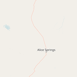
Use this park location map to pinpoint Anna's Reservoir Conservation Reserve in Australia, understand its exact geographic position, and read its mapped placement within the surrounding landscape more clearly.

Pigeon | © OpenStreetMap contributors

Location context for Anna's Reservoir Conservation Reserve

Northern Territory
Park atlas

Compare regional park geography and adjacent protected landscapes across central Australia

Exploring Parks Near Anna's Reservoir Conservation Reserve and Surrounding Protected Areas

Continue browsing adjacent protected areas and regional reserves to expand your geographic understanding of the surrounding terrain. Comparing nearby national parks reveals broader ecological and historical patterns across the arid interior.
Watercolor painting of an arid landscape featuring red sandstone rock formations, green scrub, and grasses against pale mountains.
Protected landscapeNorthern Territory
About 33 km away#1 closest

Southeast

Native Gap Conservation Reserve: Protected Landscape and Central Australian Geography

Mapped sandstone terrain within the Northern Territory Hann Range

Spanning just 11 hectares, this protected area is defined by its dramatic sandstone ridge and deep historical ties to the Arrente and Anmatyerr peoples. The reserve provides a distinct geographic reference point along the Stuart Highway, where desert flora and historic telegraph routes converge within the unique terrain of central Australia.

Area
0.11 km²
Established
1980
IUCN
V
Relief
Upland
National parkNorthern Territory
About 102 km away#2 closest

South

Tjoritja / West MacDonnell National Park: National Park Atlas and Protected Landscape

Explore the dramatic MacDonnell Ranges terrain and geography.

Delve into the protected geography of Tjoritja / West MacDonnell National Park, a significant national park in Australia's Northern Territory. This landscape features striking mountain formations, deep gorges like Standley Chasm and Glen Helen, and is intrinsically linked to the famous Larapinta Trail and the Arrernte people's cultural heritage. Understanding its mapped boundaries and regional context provides essential insight into this iconic Central Australian protected area.

Area
2,568.61 km²
Established
1992
IUCN
II
Relief
Mountain
National parkAustralia
About 116 km away#3 closest

South

West MacDonnell National Park: Australia's Outback Mountain Landscape and Protected Area

Explore mapped gorges, waterholes, and regional geography in the Red Centre.

West MacDonnell National Park serves as a key protected area within Australia's arid interior, delineating the dramatic western MacDonnell Ranges. This national park offers a unique opportunity to study its mapped landscape, characterized by ancient sandstone ridges, deep gorges, and permanent water sources that support endemic biodiversity. Its profound connection to Aboriginal cultural heritage and its status as a conservation reserve make it essential for understanding the geography and protected lands of central Australia's Red Centre.

Area
2,048 km²
Established
1992
IUCN
II
Relief
Mountain
Wildlife reserveNorthern Territory
About 145 km away#4 closest

Southeast

Kuyunba Conservation Reserve: Wildlife Protected Landscape in Central Australia

Mapped geography and rocky habitat near Alice Springs

Kuyunba Conservation Reserve represents a focused approach to habitat protection in the Northern Territory. The terrain is defined by its rocky hills and boulder-filled escarpments, offering critical shelter for wildlife in an arid, drought-adapted desert region. This site provides a clear view of how targeted land management supports specialized ecological niches in inland Australia.

Area
6.29 km²
Established
1970
IUCN
V
Relief
Upland
Nature reserveNorthern Territory
About 157 km away#5 closest

Southwest

Tnorala Conservation Reserve: Geological Wonders and Protected Landscapes of the Northern Territory

An iconic circular impact crater preserved as a cultural and natural sanctuary

Tnorala Conservation Reserve stands as a sentinel in the Northern Territory, defined by its striking five-kilometre-wide ring of hills. This protected area offers a look at a massive, ancient impact crater remnant that rises sharply from the surrounding desert plains, serving as a critical point of geological interest and a deeply revered sacred site for the Western Arrernte people.

Relief
Mountain
Climate
Arid
Access
Access unknown
Scope
Terrestrial
Protected landscapeNorthern Territory
About 159 km away#6 closest

Southeast

Corroboree Rock Conservation Reserve: Geological and Cultural Protected Area in Central Australia

Mapped protected landscape within the East MacDonnell Ranges

Corroboree Rock Conservation Reserve features a striking dolomite rock formation tied to ancient Precambrian salt lake sediments. Located east of Alice Springs, the reserve provides a protected glimpse into central Australian arid range geography and holds profound cultural importance for the Eastern Arrernte Traditional Owners within the surrounding pastoral landscape.

Area
0.07 km²
Established
1962
IUCN
V
Visitors
15K annual
Watercolor painting of a landscape with green valleys, pink and yellow mountain peaks, and distant hills
National parkNorthern Territory
About 160 km away#7 closest

Southwest

Finke Gorge National Park: Explore Its Protected Landscape and Geographic Identity

Mapped boundaries and natural terrain within Northern Territory.

Finke Gorge National Park represents a significant protected area within the Northern Territory, Australia. This national park offers valuable insights into the region's geography, mapped landscapes, and natural terrain. Detailed information helps users understand the park's protected boundaries and its role in the broader context of Australian conservation lands, ideal for focused atlas exploration.

Area
452.85 km²
Established
1966
IUCN
V
Visitors
18K annual
Protected landscapeNorthern Territory
About 162 km away#8 closest

Southeast

Trephina Gorge Nature Park: Mapped Geography and Protected Landscape Context

East MacDonnell Ranges, Northern Territory Australia

Trephina Gorge Nature Park represents a central feature of the arid MacDonnell Ranges, characterized by its deep gorge, white ghost gums against red rock, and expansive spinifex ridges. This record outlines the park boundaries, its role as a jointly managed conservation area, and its position within the broader geography of central Australia.

Established
1965
Relief
Mountain
Climate
Arid
Access
Access unknown

Common questions about visiting, size, designation, and location context for Anna's Reservoir Conservation Reserve

Anna's Reservoir Conservation Reserve FAQs for park facts, access, geography, and protected area context

Find quick answers about Anna's Reservoir Conservation Reserve, including protected-area facts, park geography, trail and visitor context, and how the park fits into its surrounding country and regional landscape.
MoriAtlas Explorer

Continue Your Protected Areas Search Across the Global Atlas

Deepen your exploration by continuing the structured search for national parks and protected areas worldwide. Utilize the comprehensive filtering capabilities to compare different conservation landscapes and refine your understanding of global park geography. Discover more about the distribution and characteristics of protected natural areas.

Global natural geography
