
Mori Atlas logo
National parkAnyuysky National Park

Traversing the transition from Amur River floodplains to the high forested Sikhote-Alin range.

Anyuysky National Park: Mapping the Protected Ecological Corridor of the Russian Far East

Anyuysky National Park protects an essential natural bridge spanning the Amur River basin and the rugged heights of the Sikhote-Alin mountain system. This vast protected landscape covers approximately 429,000 hectares of diverse terrain, ranging from alluvial lowlands to the summit of Tordoki Yani. By safeguarding these remote corridors, the park maintains vital habitats for Siberian tigers and migratory species, offering a unique window into the conservation geography of the Russian Far East.

Russian Far EastSikhote-Alin MountainsAmur RiverTaiga ForestsProtected CorridorWetland Habitat
Stylized illustration of a winding river through green mountains and forests with pine trees in the foreground.

Anyuysky National Park

National park

Park overview

Structured park overview, official facts, and landscape profile for Anyuysky National Park

Anyuysky National Park park facts, protected area profile, and essential visitor context

Review the core facts for Anyuysky National Park, including designation, size, terrain, visitor scale, habitats, and operating context in one park-focused overview.

About Anyuysky National Park

Anyuysky National Park represents one of the most ecologically significant protected areas in the Russian Far East, established to preserve the unique transitional landscapes where the Amur River lowlands meet the mountainous Sikhote-Alin range. The park's territory forms an inverted horseshoe shape extending from the flat, boggy Sredneamurskaya plain in the west to the steep mountain valleys of the Sikhote-Alin in the east. This geographic positioning creates a remarkable gradient of habitats: river floodplains and wetlands at lower elevations give way to valley-mountain sub-taiga forests dominated by Mongolian oak and Korean pine, finally reaching mountain ridges at higher altitudes. The park serves as a critical node in the network of protected areas along the Amur River, preserving what remains of the temperate forest ecosystems that once covered much of the Russian Far East. The region is notable for its exceptional biodiversity, attributed to the confluence of multiple ecoregions and the absence of glaciation in the most recent ice age, which allowed many species to survive and evolve in isolation. The Anyuy River, the park's central waterway, carries waters from the Sikhote-Alin heights westward to join the Amur, the main river of the region that flows northeast into the Sea of Okhotsk. This hydrological connection makes the park important for fish species, including salmon that migrate up the Amur and its tributary mountain streams.

Quick facts and research context for Anyuysky National Park

Anyuysky National Park occupies 429,370 hectares in Khabarovsk Krai, Russia, situated along the Anyuy River as it flows from the Sikhote-Alin Mountains westward into the Amur River. The park's horseshoe-shaped boundaries follow the dividing ridges of the Anyuy and Pihtsy river basins. Approximately 45% of the park is Far Eastern Taiga, 30% is sub-taiga mid-mountain coniferous forest, 14% is river floodplain and delta, and 11% is marshland. One-quarter of the territory consists of temperate wetlands within the Amur-Heilong River Basin. The park lies within the Ussuri broadleaf and mixed forests ecoregion, known for extraordinarily high endemism in plants and invertebrates due to the meeting of multiple ecological regions and the absence of glaciation during the most recent ice age.

Protection and recognition

Examining documented terrestrial boundaries, management scope, and international status

Anyuysky National Park Protection Status and Conservation Recognition

Anyuysky National Park maintains a documented terrestrial protection status covering vital wilderness terrain. Official conservation records outline the established management scope and administrative designation details for the protected area.

Protection details

Protection scope
Terrestrial
Transboundary protection
No
Park context

Deeper park guide and search-rich context for Anyuysky National Park

Anyuysky National Park history, landscape, wildlife, and travel context

Explore Anyuysky National Park through its history, landscape character, ecosystems, wildlife, conservation priorities, cultural context, and seasonal travel timing in a structured park guide built for atlas discovery and search intent.

Why Anyuysky National Park stands out

Anyuysky National Park is best known for its role as a vital ecological corridor linking the Amur River floodplain with the high forested mountains of the Sikhote-Alin, creating a continuous protected habitat that spans dramatically different ecosystems. The park protects significant populations of the endangered Amur tiger (Siberian tiger), one of the rarest large cats in the world. It also encompasses the valley of Tordoki Yani, the highest peak in the Sikhote-Alin range. The park's wetlands support exceptional migratory bird populations, while its forests contain the Korean pine, described by the World Wildlife Fund as the heart of the ecosystem, though this species faces severe pressure from illegal logging.
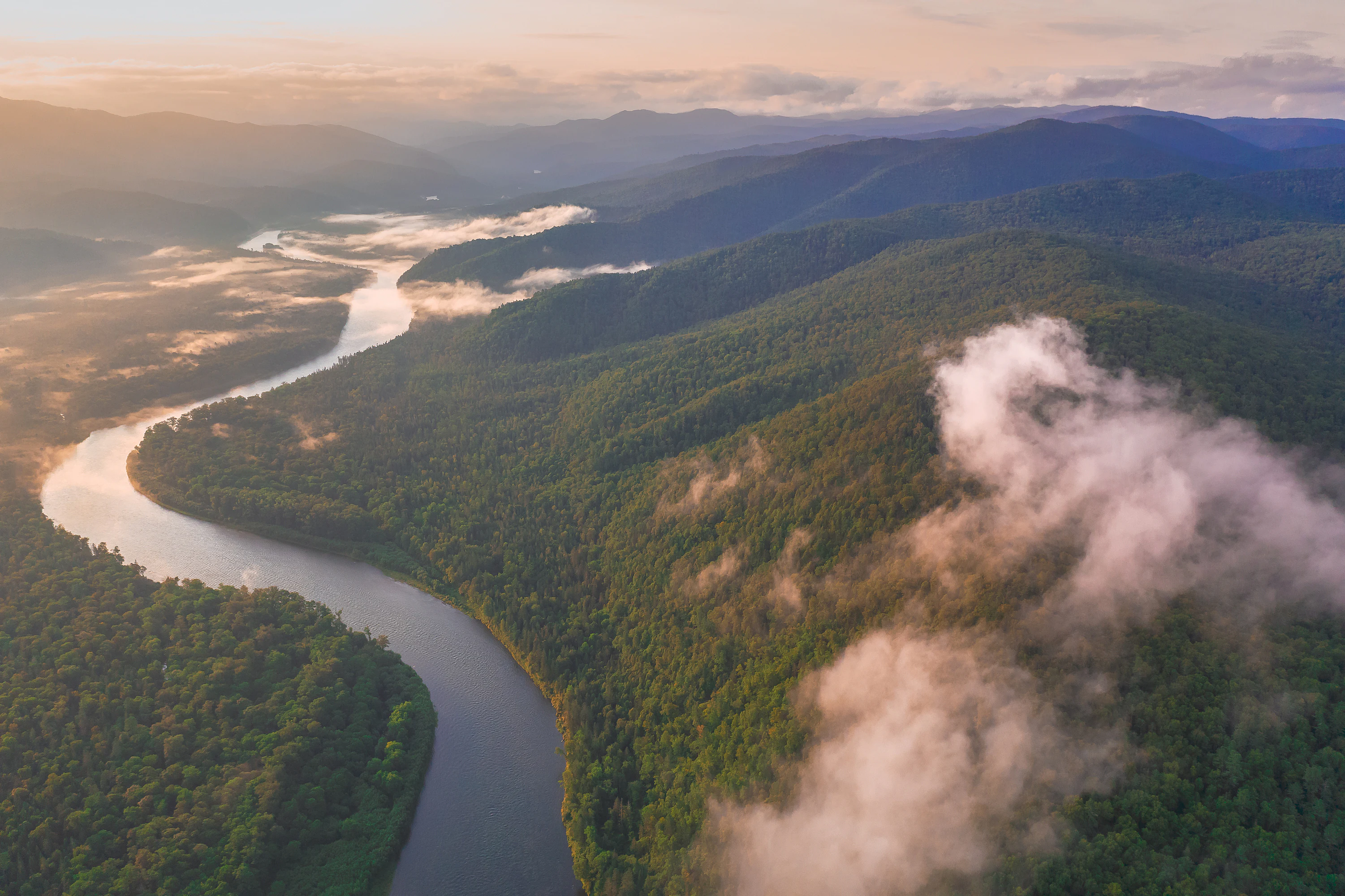
Aerial view of a winding river surrounded by dense green forest and mountains with low-lying clouds
Aerial view of the Anyui River winding through forested mountains in Anyuysky National Park

Anyuysky National Park history and protected-area timeline

Anyuysky National Park was established on May 15, 1999, formalizing protection for the Anyuy River basin and its surrounding landscapes in Khabarovsk Krai. The Nanai people have been the traditional inhabitants of the local rural settlements in this region for generations, maintaining their cultural connection to the land and its resources. During the Soviet era, the small village of Arsenyevo on the interior border of the park served as a place of exile during the 1930s collectivization period. The same village later functioned as a Japanese prisoner-of-war camp during the 1940s, reflecting the region's turbulent 20th-century history. In 2011, the Sakhalin-Khabarovsk-Vladivostok pipeline was completed, following a section of an earlier pipeline along the Amur River above Khabarovsk and running along the western border of Anyuysky Park. The operator, Gazprom, stated that minimal environmental impact requirements were observed during construction, with operations carried within existing communication lines and disturbed lands remediated. By 2012, the park reported opening a visitors center and employing approximately 50 people. A significant conservation milestone occurred in 2015 when an Amur tiger named Uporny (Russian for Stubborn) was released in the region. After wandering for six weeks, GPS tracking recorded the tiger establishing a territory within Anyuysky National Park, demonstrating the park's suitability as habitat for this endangered species.

Anyuysky National Park landscape and geographic character

The landscape of Anyuysky National Park exhibits a striking contrast between its western and eastern portions, defined by the transition from the Amur River lowlands to the Sikhote-Alin highlands. The western half of the park sits on a low-lying eastern extension of the Sredneamurskaya plain, a flat, boggy depression situated between the Sikhote-Alin ridge to the east and the Lesser Khingan mountains to the west. These alluvial lowlands of the Amur River floodplain reach altitudes as low as 40 meters. The park's boundaries form a horseshoe shape that follows the dividing ridges of the small river basins of the Anyuy and Pihtsy rivers, both of which flow west into the Amur River. The southeastern wing of the park encompasses the valley of the Pihtsy River and remains relatively flat, while the northeastern wing follows the Anyuy River valley and its tributaries through steeper, deeper canyons at an average altitude of 600 meters. The ultimate headwaters of the Anyuy rise at Tordoki Yani, the highest peak in the Sikhote-Alin mountain range. The southern boundary follows the northern line of the Three Sisters dividing range of mountains, creating the park's distinctive shape that extends from the Amur floodplain upward into the forested mountains.

Anyuysky National Park ecosystems, habitats, and plant life

Anyuysky National Park occupies a critical position within the Ussuri broadleaf and mixed forests ecoregion, an area renowned for its extraordinary level of endemism in plants and invertebrates. This exceptional biodiversity stems from multiple factors: the convergence of several distinct ecological regions, the relatively isolated and less developed state of the Russian portion of the Amur River basin compared to more heavily utilized Chinese and Korean territories, and the absence of glaciation during the most recent ice age which preserved ancient species. The park is distinguished by its continuous habitat gradient spanning from river floodplains through valley-mountain sub-taiga to mountain ridges. Approximately 45% of the park's tree cover consists of Far Eastern Taiga, while 30% is sub-taiga mid-mountain coniferous forest, 14% is river floodplain and delta, and 11% is marshland. Fully one-quarter of the park's territory comprises temperate wetlands within the Amur-Heilong River Basin, making it an important habitat for wetland species and fish in the mountain streams above the Amur. The Korean pine (Pinus koraiensis), also known as Korean cedar, has been described as the heart of the ecosystem by the World Wildlife Fund, though populations have declined by two-thirds in the past 50 years due to logging pressures.

Anyuysky National Park wildlife and species highlights

Anyuysky National Park provides crucial habitat for the endangered Amur tiger (Panthera tigris altaica), also known as the Siberian tiger, which remains a resident species within the park alongside most mountain species of the northern Sikhote-Alin. The Amur tiger population represents one of the rarest and most endangered large cat populations globally, making the park's role in its conservation critically important. The lower floodplain areas are particularly significant for their support of migratory bird populations, serving as important stopping and nesting grounds along avian migration routes. Several vulnerable species inhabit the park, including the near-threatened mountain weasel, the vulnerable Asian black bear, and the long-tailed birch mouse, which carries a data deficient conservation status according to IUCN definitions. The Amur River and its tributary streams support remarkable freshwater biodiversity, hosting more species than any other river in Russia—approximately 120 species—and particularly renowned for the salmon that migrate upstream to spawn in the mountain streams that flow through the park.

Anyuysky National Park conservation status and protection priorities

Anyuysky National Park serves as a vital component in the network of protected areas spanning the middle and lower Amur River basin, representing one of the few remaining large-scale corridors protecting continuous habitat from river floodplains to mountain forests in the Russian Far East. The park's conservation significance is amplified by its position protecting the Ussuri broadleaf and mixed forests ecoregion, which harbors extraordinarily high levels of plant and invertebrate endemism. The protection of the Amur tiger population remains a central focus, with the 2015 release and successful territorial establishment of tiger named Uporny demonstrating the park's value as tiger habitat. However, the park faces significant conservation challenges, particularly from illegal logging that has dramatically reduced Korean pine populations throughout the region. The Amur-Heilong River Basin wetlands, comprising one-quarter of the park's territory, represent another critical conservation focus, supporting both migratory bird populations and freshwater fish species including salmon. The completion of the Sakhalin-Khabarovsk-Vladivostok pipeline along the park's western border introduced potential infrastructure-related pressures that require ongoing monitoring.

Anyuysky National Park cultural meaning and human context

The Anyuysky region has been home to the Nanai people, an indigenous group whose traditional settlements have depended on the local resources for generations. The Nanai represent approximately a quarter of the population in nearby settlements, maintaining cultural practices tied to the river and surrounding forests. The local economy has historically centered on salmon fishing, logging, and hunting—activities that shaped both the landscape and the cultural identity of the region. The village of Arsenyevo, located on the interior border of the park, carries historical significance from the Soviet era when it served as a place of exile during the 1930s collectivization period and later as a Japanese prisoner-of-war camp during the 1940s. These historical layers reflect the complex human history interwoven with this remote corner of the Russian Far East, where indigenous heritage meets 20th-century geopolitical turbulence.

Top sights and standout views in Anyuysky National Park

Anyuysky National Park stands out as a critical ecological corridor spanning from the Amur River floodplain to the Sikhote-Alin mountain heights, protecting one of the most biodiverse temperate forest regions in the Northern Hemisphere. The park provides essential habitat for the endangered Amur tiger, with successful tiger reintroduction efforts demonstrating its conservation value. Its wetlands support exceptional migratory bird populations and fish species, including salmon runs in the mountain streams. The Korean pine forests, though threatened by illegal logging, remain the ecological heart of this protected landscape. The park's geography ranges from flat alluvial plains at 40 meters elevation to the heights of Tordoki Yani, the highest peak in the Sikhote-Alin, creating remarkable habitat diversity within a single protected area.

Best time to visit Anyuysky National Park

Anyuysky National Park experiences a humid continental climate with four distinct seasons, featuring cold, dry winters and warm, wet summers. The warmest period occurs during the summer months when average temperatures reach into the 20s Celsius, making this the most biologically active season when wildlife is most observable and vegetation is in full growth. Autumn brings the characteristic fall foliage for which the Ussuri broadleaf and mixed forests ecoregion is renowned, with the Korean pine and Mongolian oak displaying vibrant colors. Winter, while harsh with temperatures well below freezing and minimal precipitation, offers a stark landscape experience though access may be limited. Spring brings renewed activity as temperatures rise and migratory birds return to the wetland areas. The summer months likely offer the most accessible and rewarding visitor experience, though the park's remote location and limited infrastructure mean that any visit requires careful planning.

Monthly climate preview

Long-term temperature ranges and monthly precipitation distributions for Khabarovsk Krai

Anyuysky National Park Climate Normals and Annual Weather Patterns

Representative coordinate measurements track measured monthly temperature shifts and precipitation volumes across the protected terrain. Detailed twelve-month climate profiles supply broader analytical depth for tracking regional environmental conditions.
Annual mean1 °C
-23 °C22 °C
Jan-23°
Feb-18°
Mar-9°
Apr
May12°
Jun18°
Jul22°
Aug20°
Sep14°
Oct
Nov-9°
Dec-21°
Warmest month
July

21.6 °C

Coolest month
January

-22.9 °C

Wettest month
August

3.8 mm/day

Driest month
January

0.5 mm/day

Park location guide

Geography guide, regional context, and park location map for Anyuysky National Park

Anyuysky National Park park geography, regions, and map view in Russia

Understand where Anyuysky National Park sits in Russia through a broader geographic reading of the surrounding landscape, nearby location context, and its mapped position within the national park landscape.

How Anyuysky National Park fits into Russia

Russia is a transcontinental nation spanning eleven time zones, bordered by fourteen countries. It is the world's largest country by area, covering 17,098,246 km². Moscow is the capital and largest city, while Saint Petersburg is the second-largest and a major cultural centre.

Wider geography shaping Anyuysky National Park in Russia

Russia spans Eastern Europe and North Asia, covering 17,098,246 km². It shares land borders with fourteen countries, more than any other nation, and spans eleven time zones. The landscape includes vast plains, mountain ranges such as the Urals and Caucasus, and extensive coastlines along the Arctic Ocean, Pacific Ocean, Baltic Sea, Black Sea, and Caspian Sea.

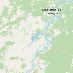
Map view of Anyuysky National Park

Use this park location map to pinpoint Anyuysky National Park in Russia, understand its exact geographic position, and read its mapped placement within the surrounding landscape more clearly.

Pigeon | © OpenStreetMap contributors

Location context for Anyuysky National Park

Khabarovsk KraiNanaysky District

Visual exploration of Amur River floodplains and Sikhote-Alin mountain habitats

Anyuysky National Park Photos and Protected Landscape Scenery

Anyuysky National Park photography reveals the dramatic transition from low-lying river plains to high forested mountain ranges. Visual reference records capture the diverse terrain, taiga forests, and protected ecological corridors of the Russian Far East.

Aerial view of a winding river surrounded by dense green forest and mountains with low-lying clouds

Park atlas

Compare surrounding regional geography and connected taiga landscapes

Explore Protected Areas and Parks Near Anyuysky National Park

Browse nearby national parks and protected areas sharing the ecological corridors of the Russian Far East. Examining adjacent reserves reveals how lowland river basins transition upward into rugged mountain ranges.
Watercolor illustration of a serene river landscape with birch trees in the foreground, forest in the midground, and soft-colored mountain ranges in the background.
National parkKhabarovsk Krai
About 0 km away#1 closest

Northwest

Anyuysky National Park: Protected Sikhote-Alin Forests and River Valley Geography

An intact wilderness refuge in Khabarovsk Krai, Russia.

Anyuysky National Park stands as a primary reference for intact East Asian ecosystems. The park encompasses a dramatic landscape of forested ridges, riparian zones, and the signature Anyui Pillars. These sandstone rock formations overlook a valley that remains largely untouched by human activity, serving as a critical habitat within the greater Sikhote-Alin range. This geography offers a rare look at the transition from high-mountain terrain to the expansive Amur River basin.

Area
4,293 km²
Established
2007
IUCN
II
Relief
Mountain
Watercolor painting showing a river flowing through a forested valley with mountains in the background
National parkPrimorsky Krai
About 241 km away#2 closest

South

Bikin National Park: Protected Landscapes and Geographic Boundaries in Primorsky Krai

Old-growth forest wilderness in the Sikhote-Alin range

Spanning over 1.16 million hectares, Bikin National Park protects one of the most biodiverse temperate forest ecosystems in the Northern Hemisphere. The mountainous terrain and the Bikin River basin provide essential habitats for rare wildlife, representing a world-class conservation landscape within the Russian Far East.

Area
11,600 km²
Established
2015
IUCN
II
Relief
Mountain
A soft watercolor illustration showing a winding river through a forested valley with rolling hills in the background.
National parkPrimorsky Krai
About 312 km away#3 closest

South

Bikin National Park: Protected Landscape Map and Regional Geography in Primorsky Krai

A vast wilderness corridor in the Sikhote-Alin mountain range

Bikin National Park is a prominent protected area in Primorsky Krai, encompassing the Bikin River valley and surrounding mountain ridges. This wilderness preserve is integral to the survival of the Amur tiger and features a distinct mix of coniferous and broadleaf forest ecosystems. The geography highlights a transition between boreal and temperate forest zones, maintained as a largely untouched natural landscape within the Russian Far East.

Area
11,604.7 km²
Established
2015
IUCN
II
Relief
Mountain
Watercolor painting of a landscape featuring green forests, distant mountains, and a body of water in the foreground
National parkPrimorsky Krai
About 412 km away#4 closest

South

Udegeyskaya Legenda National Park: National Park with Mapped Protected Boundaries

Explore Protected Landscape Geography in Primorsky Krai

Gain an atlas-level understanding of Udegeyskaya Legenda National Park, a designated national park situated in Russia's Primorsky Krai. This resource provides insights into the park's geographic setting and the extent of its protected landscape. It is designed for users interested in the mapped features and regional context of protected natural areas, offering a clear view of the park's role within its geographic domain.

Area
1,037 km²
Established
2007
IUCN
II
Relief
Mountain
National parkHokkaido
About 591 km away#5 closest

Southeast

Rishiri-Rebun-Sarobetsu National Park: Volcanic Islands and Coastal Wetlands of Northern Hokkaido

Explore its mapped geography and unique subarctic alpine flora.

Rishiri-Rebun-Sarobetsu National Park in Hokkaido, Japan, offers a unique exploration of dramatic volcanic islands and vital coastal wetland ecosystems. This protected area showcases striking geological formations, from the conical peaks of Rishiri and Rebun islands to the vast peat bogs of the Sarobetsu Plain. Its subarctic environment supports a rich tapestry of alpine flora, providing a distinct case study in protected landscape geography and mapping for the region.

Area
241.66 km²
Established
1974
IUCN
II
Visitors
730K annual
National parkKhabarovsk Krai
About 622 km away#6 closest

North

Shantar Islands National Park: Remote Archipelago Atlas with Rugged Terrain

Mapping protected marine and island geography in Khabarovsk Krai.

Shantar Islands National Park represents a significant protected landscape within Khabarovsk Krai, notable for its dramatic coastal geography, mountainous terrain, and rich marine ecosystems. This national park, encompassing a chain of islands in the Sea of Okhotsk, is a vital habitat for marine mammals and seabird colonies. Explore its mapped boundaries and unique regional atlas context, understanding its role as a protected coastal area in the Russian Far East.

Area
5,155 km²
Established
2013
IUCN
II
Relief
Mountain
National parkPrimorsky Krai
About 674 km away#7 closest

South

Zov Tigra National Park: Regional Geography and Sikhote-Alin Protected Landscape Analysis

A core conservation area in the southern Russian Far East.

Zov Tigra National Park encompasses an essential segment of the Sikhote-Alin mountain range, featuring deep river gorges and soaring ridges that reach the highest elevations in Primorsky Krai. This protected expanse integrates diverse forest types and serves as a key habitat link for rare species. Our atlas data details the terrain, elevation gradients, and river corridors that define this significant Russian conservation zone.

Area
834.9 km²
Established
2007
IUCN
II
Relief
Mountain
Watercolor painting of a valley landscape with a river, hills, trees, and a sky with sunrise colors
National parkPrimorsky Krai
About 674 km away#8 closest

South

Zov Tigra National Park: Geography and Protected Wilderness of the Sikhote-Alin Range

A rugged mountain landscape and critical conservation area in Primorsky Krai.

Zov Tigra National Park features a dramatic, forest-covered terrain within the southern Sikhote-Alin mountains. With peaks rising to 1,854 meters and deep river canyons, this protected area serves as a cornerstone for wildlife recovery and ecological monitoring in the region. Explore the topographical characteristics of this unique mountain habitat and its position in the broader Primorsky Krai geography.

Area
834 km²
Established
2007
IUCN
II
Relief
Mountain

Common questions about visiting, size, designation, and location context for Anyuysky National Park

Anyuysky National Park FAQs for park facts, access, geography, and protected area context

Find quick answers about Anyuysky National Park, including protected-area facts, park geography, trail and visitor context, and how the park fits into its surrounding country and regional landscape.
MoriAtlas Explorer

Continue Your Protected Areas Search Across the Global Atlas

Deepen your exploration by continuing the structured search for national parks and protected areas worldwide. Utilize the comprehensive filtering capabilities to compare different conservation landscapes and refine your understanding of global park geography. Discover more about the distribution and characteristics of protected natural areas.

Global natural geography