Mori Atlas logo
National parkShantar Islands National Park

Mapping the dramatic landscape and rich marine environments of this remote Russian Far East national park.

Shantar Islands National Park: A Protected Archipelago of Rugged Coastal Geography

Shantar Islands National Park, situated in Russia's Khabarovsk Krai, offers a profound exploration of remote subarctic island geography. This protected national park encompasses a dramatic archipelago characterized by mountainous terrain, steep cliffs, and extensive coastal waters of the Sea of Okhotsk. Discover the unique atlas context of these islands, known for their significant marine mammal populations and vital seabird colonies, providing a crucial anchor for understanding regional protected lands.

marine protected areaRussian Far Eastsubarctic islandscoastal ecosystemsbird coloniesmarine mammals

Shantar Islands National Park

National park

Park overview

Structured park overview, official facts, and landscape profile for Shantar Islands National Park

Shantar Islands National Park park facts, protected area profile, and essential visitor context
Review the core facts for Shantar Islands National Park, including designation, size, terrain, visitor scale, habitats, and operating context in one park-focused overview.

About Shantar Islands National Park

Shantar Islands National Park represents one of the most significant protected coastal and maritime ecosystems in the Russian Far East. The archipelago consists of 15 islands and numerous rocky outcrops rising from the Sea of Okhotsk, creating a remote and largely undisturbed wilderness environment. The park's dual terrestrial and marine designation reflects the interconnected nature of the islands' ecosystems, where the surrounding waters are as ecologically important as the land itself.

The park is administered by FGBU Shantar Islands under the Russian Ministry of Natural Resources. Management zones were further refined in 2017, with certain areas designated for complete protection where economic activities are prohibited. The park's stated purposes include protecting habitat for vulnerable species, combating poaching, supporting scientific research, and developing sustainable ecological tourism. Current infrastructure remains limited as the park continues to develop visitor systems and operational frameworks.

The isolation of the Shantar Islands has been crucial to their ecological integrity. The islands have no permanent human population, with only a meteorological station and occasional scientific camps present. This absence of permanent settlement has allowed wildlife populations to maintain natural patterns, particularly for marine mammals that use the surrounding waters as critical habitat.

Quick facts and research context for Shantar Islands National Park

Shantar Islands National Park protects a remote archipelago in Khabarovsk Krai, Russia, covering 515,500 hectares including 274,484 hectares of marine waters. The park encompasses 15 uninhabited islands in the Sea of Okhotsk, with the highest point at 720 meters. The climate is subarctic with only 2-3 months of ice-free water annually due to prevailing northeast winds pushing ice floes into the coastal area. The park was established in 2013 after operating as a state reserve since 1999, with the primary mission of protecting vulnerable species and preventing poaching while supporting scientific research and ecological tourism.

Park context

Deeper park guide and search-rich context for Shantar Islands National Park

Shantar Islands National Park history, landscape, wildlife, and travel context
Explore Shantar Islands National Park through its history, landscape character, ecosystems, wildlife, conservation priorities, cultural context, and seasonal travel timing in a structured park guide built for atlas discovery and search intent.

Why Shantar Islands National Park stands out

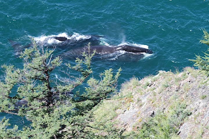
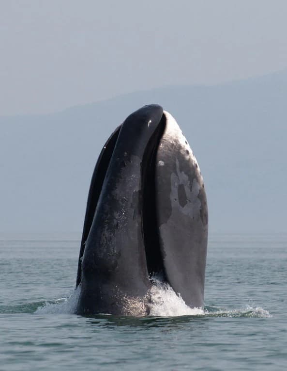
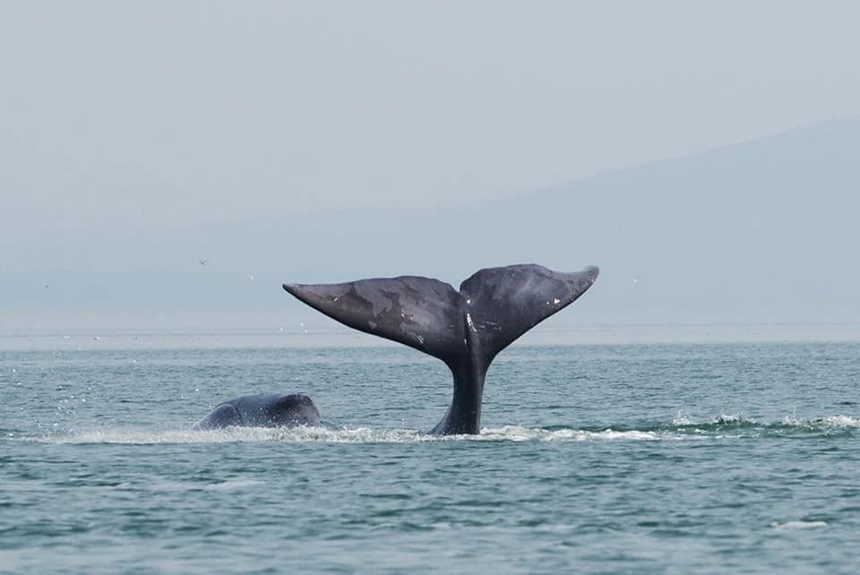
Shantar Islands National Park is especially renowned for its exceptional marine mammal populations and significant bird colonies. The surrounding waters support critical populations of Steller Sea Lions, various seal species, and diverse cetaceans including gray whales, bowhead whales, minke whales, belugas, and killer whales. The islands host very large seabird colonies and serve as important habitat for endangered species such as Blakiston's fish owl, the largest owl species in the world, and Steller's sea eagle, one of the heaviest eagles globally. The park also protects important salmon spawning grounds in its coastal waters.

Shantar Islands National Park history and protected-area timeline

The Shantar Islands have a long recorded history of human utilization, primarily as bases for fur trapping, whaling, fishing, and hunting activities. American whaling ships specifically hunted bowhead whales around the islands between 1852 and 1907, establishing the archipelago's international maritime significance during the nineteenth century. Historical logging operations also occurred on the islands, and the broader region is considered to have potential mineral reserves, creating ongoing economic pressures on the area.

The islands were formally protected as a state nature reserve in 1999, establishing the first institutional conservation framework for the archipelago. This protection was upgraded and re-established as a federal national park in 2013, reflecting the growing recognition of the area's ecological significance. The transition to national park status expanded the management mandate to include explicit goals of supporting scientific study and developing ecological tourism alongside core conservation objectives. In 2017, additional regulatory measures were adopted to establish zoned protection areas with complete prohibition on economic activities within certain zones.

Shantar Islands National Park landscape and geographic character

The Shantar Islands present a dramatic coastal landscape characterized by mountainous terrain, rugged cliffs, and exposed rocky shorelines. The archipelago lies on the eastern side of Uda Bay, with tidal ranges reaching 5 to 8 meters and powerful currents surrounding the islands. The two largest islands—Bolshoy Shantar at approximately 30 by 45 miles and Feklistova Island about 20 kilometers to the west—dominate the terrestrial environment, together comprising about 75% of the land area.

The islands feature moderatly mountainous topography with the highest points reaching 720 meters above sea level. Steep cliff faces drop directly into the sea, creating scenic coastal vistas typical of remote oceanic islands. The surrounding maritime environment includes extensive shallow waters and productive fishing grounds, with fog being a frequent occurrence around the archipelago. The landscape reflects the islands' geological history as a recently connected mainland area, with terrain that shares more similarities with the adjacent coast than with isolated oceanic islands.

Shantar Islands National Park ecosystems, habitats, and plant life

The terrestrial vegetation of the Shantar Islands consists primarily of dark coniferous forests covering the larger islands. Siberian spruce, larch, cedar, and birch dominate the forest composition, creating a characteristic taiga ecosystem across the islands' interior. Notably, the islands contain no endemic plant species—a direct result of their relatively recent separation from the mainland approximately 9,000-10,000 years ago. This geological history means the islands' flora represents an extension of continental species rather than isolated island evolution.

The surrounding marine environment belongs to the North Temperate Indo-Pacific / Sea of Okhotsk maritime ecoregion, classified as WWF Maritime Ecoregion #204. This ecoregion is characterized by cool but nutrient-rich waters that support enormous fisheries and exceptional biodiversity. Coastal currents maintain cooler temperatures near the islands compared to areas further offshore, and the mixing of water masses creates productive conditions that sustain the extraordinary concentrations of marine life for which the area is renowned.

Shantar Islands National Park wildlife and species highlights

The wildlife of Shantar Islands National Park is exceptionally rich, particularly in marine environments. The surrounding waters support important populations of marine mammals including Steller Sea Lions, various seal species, and at least five cetacean species: gray whales, bowhead whales, minke whales, belugas, and killer whales. The coastal waters also contain critical spawning grounds for salmon species, supporting both commercial and ecological importance.

Terrestrial mammals present on the islands include brown bear, caribou, red fox, sable, river otter, and ringed seals. Over 240 bird species either nest on the islands or migrate through the archipelago, making it one of the most significant seabird nesting areas in the region. The endangered species protected within the park include Blakiston's fish owl—the world's largest owl species—and Steller's sea eagle, one of the largest and most powerful eagles in the world. These species represent conservation priorities for the park's management.

Shantar Islands National Park conservation status and protection priorities

Shantar Islands National Park plays a crucial role in protecting some of the Russian Far East's most significant coastal and marine ecosystems. The park's designation specifically addresses the protection of vulnerable species, with particular emphasis on combating poaching in marine mammal populations. The surrounding waters are protected with fishing restrictions extending 1-3 miles from the coast to safeguard salmon spawning areas and marine mammal habitat.

The 2017 additional protections established zoned management approaches, with certain areas designated for complete exclusion of economic activities. This zoning system reflects growing understanding of the need to balance conservation with sustainable use, particularly in marine environments. The park also supports scientific study as a core function, recognizing the ecological importance of this relatively undisturbed coastal system. The international significance of the area is underscored by the presence of globally endangered species and the transboundary nature of migratory marine mammals.

Shantar Islands National Park cultural meaning and human context

The Shantar Islands have been sites of human activity for centuries, primarily centered on resource extraction rather than permanent settlement. The islands served as bases for fur trapping operations, commercial whaling, fishing, and seal hunting throughout their recorded history. The nineteenth-century American whaling industry specifically targeted bowhead whales in these waters between 1852 and 1907, leaving a documented maritime heritage associated with the archipelago.

Today, the islands remain uninhabited except for a single meteorological station and occasional scientific research camps. This absence of permanent community distinguishes the Shantar Islands from many other protected areas and reflects both their remote character and the priority placed on conservation over settlement. The cultural context remains one of historical resource use and ongoing scientific interest rather than indigenous community presence or traditional land management.

Top sights and standout views in Shantar Islands National Park

Shantar Islands National Park stands out for its exceptional marine biodiversity and remote wilderness character. The park protects one of the most significant marine mammal habitats in the Russian Far East, with regular populations of Steller Sea Lions, several whale species, and seal colonies. The bird populations are equally remarkable, with over 240 species and particularly important nesting populations of endangered raptors including Steller's sea eagle. The dramatic island landscape of rugged cliffs, mountainous terrain, and productive coastal waters creates a striking wilderness environment. The park's relatively recent establishment as a national park (2013) and ongoing development of visitor infrastructure means the area remains truly remote and uncrowded compared to more established protected areas.

Best time to visit Shantar Islands National Park

Visiting Shantar Islands National Park is heavily constrained by the severe subarctic climate and sea ice conditions. The islands experience only 2-3 months of ice-free water each year, typically during the summer months. The short cool summer period represents the primary window for any potential park access, though fog remains frequent even during this season. The long cold winters dominate the year, with extensive ice coverage making the marine environment inaccessible. Any visit planning must account for these extreme seasonal limitations and the park's developing visitor infrastructure.

Park location guide

Geography guide, regional context, and park location map for Shantar Islands National Park

Shantar Islands National Park park geography, regions, and map view in Russia
Understand where Shantar Islands National Park sits in Russia through a broader geographic reading of the surrounding landscape, nearby location context, and its mapped position within the national park landscape.

How Shantar Islands National Park fits into Russia

Russia is a transcontinental nation spanning eleven time zones, bordered by fourteen countries. It is the world's largest country by area, covering 17,098,246 km². Moscow is the capital and largest city, while Saint Petersburg is the second-largest and a major cultural centre.

Wider geography shaping Shantar Islands National Park in Russia

Russia spans Eastern Europe and North Asia, covering 17,098,246 km². It shares land borders with fourteen countries, more than any other nation, and spans eleven time zones. The landscape includes vast plains, mountain ranges such as the Urals and Caucasus, and extensive coastlines along the Arctic Ocean, Pacific Ocean, Baltic Sea, Black Sea, and Caspian Sea.

Map view of Shantar Islands National Park

Use this park location map to pinpoint Shantar Islands National Park in Russia, understand its exact geographic position, and read its mapped placement within the surrounding landscape more clearly.

Pigeon | © OpenStreetMap contributors

Location context for Shantar Islands National Park

Khabarovsk Krai
Park atlas

Trace nearby protected landscapes and marine ecosystems, expanding your geographic view beyond Shantar Islands National Park into broader regional conservation.

Explore Nearby National Parks and Protected Areas Beyond Shantar Islands
Explore other national parks and protected areas in the Russian Far East, comparing their distinct coastal and marine landscapes with Shantar Islands National Park. Uncover the regional spread of protected ecosystems and their interconnectedness, gaining a broader understanding of conservation landscapes and geographic features.
National parkAmur Oblast

Tokinsko-Stanovoy National Park: Protected Landscape Geography and Atlas Context

National Park in Amur Oblast, Russia

Delve into the specifics of Tokinsko-Stanovoy National Park, a designated national park within Amur Oblast. This entry provides essential context on its protected landscape characteristics and its place in the regional geography. Understand the park's mapped boundaries and discover its natural terrain as part of a larger atlas-driven exploration of protected areas in the Russian Far East.

Area
2,430 km²
Established
2019
IUCN
II
Watercolor painting of a river flowing through green hills with pink flowering trees and distant mountains under a light sky
National parkKhabarovsk Krai

Anyuysky National Park: Mapped Protected Landscape and Geographic Setting in Khabarovsk Krai

Explore its unique terrain and ecological corridor status.

Delve into Anyuysky National Park, a crucial protected area in Khabarovsk Krai known for its role as an ecological corridor linking the Amur River floodplain to the Sikhote-Alin mountains. This page provides detailed insight into the park's mapped landscape, from its western alluvial plains to its eastern mountain canyons, highlighting its distinct geographic features and the diverse habitats it safeguards. Understand its significance as a protected zone and its place within the regional geography for atlas-based discovery.

Area
4,294 km²
Established
1999
IUCN
II
Relief
Mixed relief
Watercolor illustration showing green hills, a river, and grassy foreground
Nature reserveSakha Republic

Lena Pillars Nature Reserve: Mapped Protected Area in Sakha Republic's Vast Geography

Explore the regional landscape and park boundaries.

Discover Lena Pillars Nature Reserve, a key protected area located within the expansive Sakha Republic of Russia. This page offers focused atlas exploration, detailing the park's geographic setting and its mapped boundaries against the backdrop of Siberia's largest federal subject. Understand the unique natural landscape context and its significance within regional conservation efforts, providing structured geographic data for your exploration.

Area
13,870 km²
Relief
Lowland
Climate
Subpolar
Access
Moderate access
National parkPrimorsky Krai

Bikin National Park: A Vast Protected Landscape in Primorsky Krai's Sikhote-Alin Mountains

Explore Russia's largest old-growth forest and Amur tiger stronghold.

Bikin National Park is a monumental protected area safeguarding the largest remaining tract of old-growth temperate rainforest in the Northern Hemisphere. Situated within Primorsky Krai, it serves as a vital refuge for an estimated 10% of the world's wild Amur tigers, making its mapped boundaries essential for conservation. Recognized as a World Heritage Site, the park's extensive forests and complex terrain offer a unique glimpse into one of Asia's last great wilderness areas, supporting unparalleled biodiversity and crucial ecological processes.

Area
11,600 km²
Established
2015
IUCN
II
Relief
Mountain
Watercolor painting of a landscape featuring green forests, distant mountains, and a body of water in the foreground
National parkPrimorsky Krai

Udegeyskaya Legenda National Park: National Park with Mapped Protected Boundaries

Explore Protected Landscape Geography in Primorsky Krai

Gain an atlas-level understanding of Udegeyskaya Legenda National Park, a designated national park situated in Russia's Primorsky Krai. This resource provides insights into the park's geographic setting and the extent of its protected landscape. It is designed for users interested in the mapped features and regional context of protected natural areas, offering a clear view of the park's role within its geographic domain.

Area
1,037 km²
Established
2007
IUCN
II
Relief
Mountain
National parkZabaykalsky Krai

Kodar National Park: Protected National Park with Zabaykalsky Krai Geographic Context

Atlas exploration of mapped boundaries and regional landscape.

Delve into the protected landscape of Kodar National Park, a significant national park located in Zabaykalsky Krai, Russia. This resource provides detailed insights into its geographic setting, offering users a clear view of its mapped boundaries and its position within the regional atlas. Understand the protected-area nature of Kodar National Park and its contribution to the mapped natural landscapes of its geographical vicinity.

Area
4,917 km²
Established
2016
IUCN
II
Relief
Mountain
National parkPrimorsky Krai

Zov Tigra National Park: National Park Protected Area and Mapped Landscape

Explore the protected lands and regional geography of Primorsky Krai.

Zov Tigra National Park represents a vital protected area within Russia's Primorsky Krai region. This detailed atlas entry provides specific insights into its mapped boundaries, geographic setting, and status as a national park. Understand the park's landscape context and its role within the broader regional geography, facilitating structured discovery for geographers and park explorers alike.

Area
834 km²
Established
2007
IUCN
II
Relief
Mountain
Watercolor illustration of rolling green hills, scattered trees, and distant mountains under a pale sky.
National parkPrimorsky Krai

Land of the Leopard National Park: Protected Area Map and Geographic Context in Primorsky Krai

Atlas exploration of Russia's critical Amur leopard habitat.

Investigate Land of the Leopard National Park, a nationally significant protected area situated in Primorsky Krai, Russia. This park is celebrated as the exclusive remaining sanctuary for the critically endangered Amur leopard, making it a focal point for global conservation efforts. Its varied landscape, characterized by forested slopes and mountainous terrain, serves as essential habitat not only for leopards but also for Siberian tigers. The park provides a rich geographic setting for understanding protected land distribution and regional ecosystems within the Russian Far East.

Area
2,799 km²
Established
2012
IUCN
II
Relief
Mixed relief

Common questions about visiting, size, designation, and location context for Shantar Islands National Park

Shantar Islands National Park FAQs for park facts, access, geography, and protected area context
Find quick answers about Shantar Islands National Park, including protected-area facts, park geography, trail and visitor context, and how the park fits into its surrounding country and regional landscape.
MoriAtlas Explorer

Continue Your Protected Areas Search Across the Global Atlas

Deepen your exploration by continuing the structured search for national parks and protected areas worldwide. Utilize the comprehensive filtering capabilities to compare different conservation landscapes and refine your understanding of global park geography. Discover more about the distribution and characteristics of protected natural areas.

Global natural geography