
Mori Atlas logo
National parkUdegeyskaya Legenda National Park

Discover the geographic boundaries and natural landscape context of this vital protected area.

Udegeyskaya Legenda National Park: A Protected National Park in Primorsky Krai

Udegeyskaya Legenda National Park stands as a significant national park within the Primorsky Krai region of Russia. This page offers a detailed atlas-style view of the park's protected boundaries and its place within the surrounding natural geography. Users can explore the mapped landscape context, understanding how this protected area contributes to the regional natural heritage and offers a unique perspective for geographic discovery.

National ParksRussian Far EastSikhote-Alin MountainsAmur Tiger HabitatConiferous-Deciduous ForestsUdege People
Illustration of a river flowing through a forested mountain valley with autumn-colored trees and rocky shoreline

Udegeyskaya Legenda National Park

National park

Park overview

Structured park overview, official facts, and landscape profile for Udegeyskaya Legenda National Park

Udegeyskaya Legenda National Park park facts, protected area profile, and essential visitor context

Review the core facts for Udegeyskaya Legenda National Park, including designation, size, terrain, visitor scale, habitats, and operating context in one park-focused overview.

About Udegeyskaya Legenda National Park

Udegeyskaya Legenda National Park occupies a strategically important position in the Sikhote-Alin mountain range of the Russian Far East. The park spans the western slope of the Central Sikhote-Alin, protecting some of the most ecologically diverse forests in Russia. This region represents a remarkable biological crossroads where the continental climate of Eurasian landmass meets the maritime influence of the Pacific Ocean, creating conditions that support an extraordinary diversity of plant and animal life. The park's river valleys, particularly those of the Armu River and Bolshaya Ussurka River, form the hydrological backbone of the protected area, creating habitats that support both aquatic wildlife and the larger mammals that depend on riparian corridors. The park serves a dual purpose of biodiversity conservation and cultural preservation, as it encompasses territory that has been the traditional homeland of the Udege people, an indigenous group whose hunting-fishing culture has shaped the relationship between humans and this landscape for generations.

Quick facts and research context for Udegeyskaya Legenda National Park

Udegeyskaya Legenda National Park spans 103,744 hectares in Krasnoarmeysky District of Primorsky Krai, Russian Far East, at coordinates 45.817°N 135.417°E. The park was established in 2007 and is managed as an IUCN Category II protected area. Elevations range from 180 meters in river lowlands to 1,330 meters at the mountain crest. The park protects river valleys feeding the Armu River and Bolshaya Ussurka River, which flow westward to the Ussuri River and ultimately the Amur River system. The climate is humid continental with warm summers (Dfb Köppen classification), featuring cold snowy winters and mild summers with average precipitation of about 800 mm annually.

Protection and recognition

Documented terrestrial management scope and geographic conservation status.

Udegeyskaya Legenda National Park Protection Status and Designation Details

Factual database records outline the formal terrestrial protection status and established management framework of Udegeyskaya Legenda National Park. Tracking official conservation parameters helps geographers and researchers understand how regional wilderness zones are mapped and maintained within the global protected areas framework.

Protection details

Protection scope
Terrestrial
Transboundary protection
No
Park context

Deeper park guide and search-rich context for Udegeyskaya Legenda National Park

Udegeyskaya Legenda National Park history, landscape, wildlife, and travel context

Explore Udegeyskaya Legenda National Park through its history, landscape character, ecosystems, wildlife, conservation priorities, cultural context, and seasonal travel timing in a structured park guide built for atlas discovery and search intent.

Why Udegeyskaya Legenda National Park stands out

Udegeyskaya Legenda is most notably known as a refuge for the endangered Amur tiger, one of the rarest big cats in the world, which inhabits the forests of the western Sikhote-Alin slope. The park protects some of the most biodiverse forests in Russia, where continental and maritime ecological zones converge, creating a unique mixing ground for temperate and subtropical species. The area is also celebrated for its abundant fishing and boating opportunities on the streams and rivers that traverse the protected valleys, as well as for its cultural significance as the ancestral homeland of the Udege people, an indigenous group with a traditional hunting-fishing culture now numbering under 1,500 individuals.
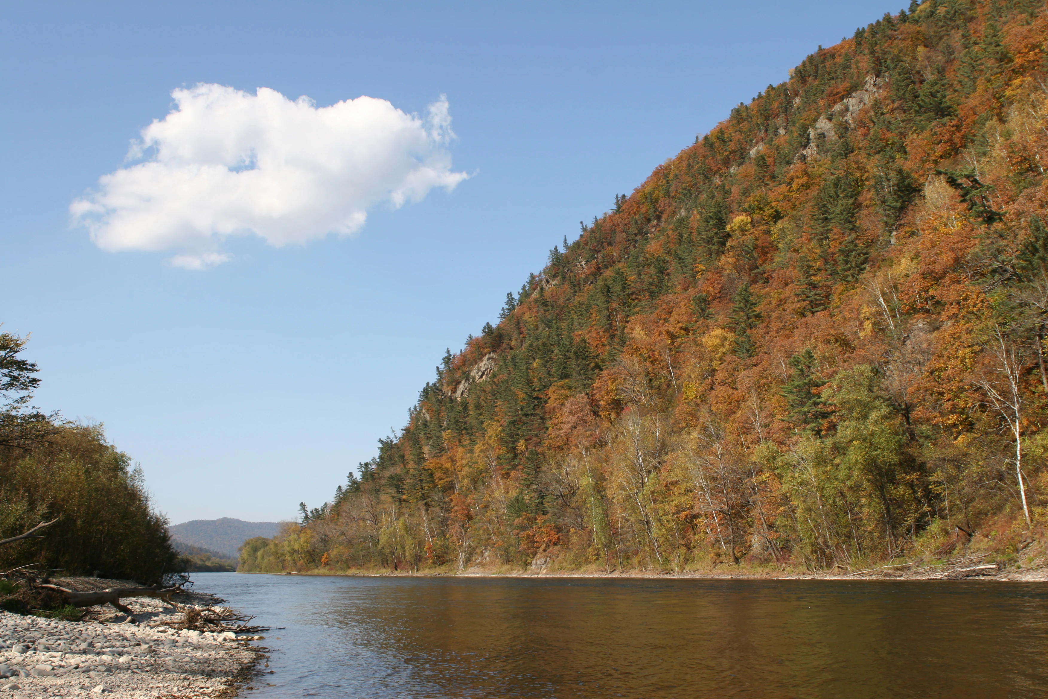
Calm river with rocky shoreline, surrounded by steep forested hills covered in orange and red autumn foliage under a clear blue sky with one cloud
Bolshaya Ussurka River flows through autumn-colored forested hills in Udegeyskaya Legenda National Park

Udegeyskaya Legenda National Park history and protected-area timeline

Udegeyskaya Legenda National Park was established in 2007 as part of Russia's expanding network of protected areas in the ecologically rich Primorsky Krai region. The creation of the park reflected growing recognition of the Sikhote-Alin region's global significance for biodiversity conservation, particularly for the endangered Amur tiger population. The park boundaries encompass the historic homeland of the Udege people, an indigenous group whose traditional territory spans this portion of the Sikhote-Alin mountains. A 2010 census recorded fewer than 1,500 Udege individuals remaining, making the community one of Russia's smallest indigenous peoples. The park was specifically designed to support both the conservation of natural ecosystems and the cultural continuation of the Udege way of life, incorporating zones that allow for sustainable traditional activities alongside strict wildlife protection areas.

Udegeyskaya Legenda National Park landscape and geographic character

The topography of Udegeyskaya Legenda is characterized by mountain valleys and steep forested slopes that descend from the central Sikhote-Alin crest toward the Amur River basin. Elevations within the park range from 180 meters in the river lowlands to 1,330 meters at the mountain crest, creating distinct altitudinal zones that support varied forest types. The river valleys are narrow and winding, following the geological fault lines of the Sikhote-Alin. The main valley of the Ussurka runs north-northeast along this fault system, passable to small boats in its lower regions where oxbow lakes and marshy banks create complex wetland habitats. Slope angles average 10 to 15 degrees but can reach 15 to 25 degrees on steeper terrain. In contrast to the meandering lowland rivers, the Armu River features rocky and steep banks with frequent rapids and waterfalls. Three small settlements exist within the park: Far Kut, Dersu, and Ostovnoe, representing the human presence within this largely wild landscape.

Udegeyskaya Legenda National Park ecosystems, habitats, and plant life

Udegeyskaya Legenda lies within the Ussuri broadleaf and mixed forests ecoregion, one of the most botanically diverse areas in Russia. The park is situated at a remarkable ecological crossroads, combining continental and maritime influences while marking the boundary between ancient stable base rocks to the west and more active tectonic formations to the east. This positioning, along with the area's location on major animal migration routes and its escape from both recent glaciation and extensive human development, has resulted in exceptionally high biodiversity. The park supports distinct altitudinal vegetation zones: deciduous forests of elm, ash, and Manchurian walnut in the lowlands, transitioning through cedar pine and spruce forests to spruce-fir forests with birch at higher elevations. Thirty species of vascular plants require protection within the park, including Japanese mountain yam, fox nut, Pacific saxifrage, ginseng, and yew. The freshwater ecosystems belong to the Lower Amur freshwater ecoregion, characterized by stream systems with strongly eroded river valleys and well-developed floodplains.

Udegeyskaya Legenda National Park wildlife and species highlights

The wildlife of Udegeyskaya Legenda is remarkable for its diversity and the presence of flagship species. The park provides critical habitat for the endangered Amur tiger, one of the world's rarest big cats, which roams the forests of the western Sikhote-Alin slope. Large mammals are well represented, with both brown bears and Asian black bears common throughout the forested terrain. The smaller forest mammals include sable, marten, badger, weasels, lynx, and leopard cat. River environments support minks and otters along the banks, while the lowland rivers and surrounding wetlands provide habitat for elk and moose. The region is exceptionally rich in insects, with over 10,000 species estimated to inhabit the territory, including a species of longhorn beetle believed to be the largest in Russia. This extraordinary insect diversity contributes to the park's status as one of the most biodiverse protected areas in the country.

Udegeyskaya Legenda National Park conservation status and protection priorities

Udegeyskaya Legenda plays a crucial role in the conservation network of the Russian Far East, serving as a connecting protected area between the Sikhote-Alin Nature Reserve to the east and the Amur River basin to the west. The park forms part of a larger constellation of protected areas that includes Zov Tigra National Park and Lazovsky Nature Reserve to the south and Anyuysky National Park to the north, creating corridors that allow wildlife movement across the Sikhote-Alin region. The protection of the Amur tiger population represents a particularly significant conservation priority, as this subspecies has been reduced to a tiny population living primarily in the Sikhote-Alin mountains. The park's design also addresses the conservation needs of the Udege people, incorporating support for their traditional land use practices alongside strict protection zones for sensitive ecosystems.

Udegeyskaya Legenda National Park cultural meaning and human context

Udegeyskaya Legenda encompasses the ancestral homeland of the Udege people, an indigenous group whose traditional culture centers on hunting and fishing. The Udege have inhabited the Sikhote-Alin region for generations, developing intimate knowledge of the forest ecosystems and maintaining cultural practices that are closely tied to the natural environment. A 2010 census recorded fewer than 1,500 Udege individuals, making this one of Russia's smallest indigenous communities. The park's establishment acknowledged both the ecological significance of the region and the cultural importance of preserving the Udege connection to their ancestral lands. Traditional elements such as the gabled yurt dwellings, as documented in early 20th-century photography, represent the cultural heritage that the park aims to protect alongside its natural values.

Top sights and standout views in Udegeyskaya Legenda National Park

Udegeyskaya Legenda National Park offers visitors access to some of the most pristine and biodiverse forests in the Russian Far East, with the opportunity to explore ancient yew groves, paddle rivers through scenic valleys, and witness habitats that support the endangered Amur tiger. The park's position on the western slope of the Sikhote-Alin makes it more accessible from the main transportation routes than many other protected areas in the region, while its ecological significance stems from the remarkable convergence of continental and maritime influences that create Russia's most biodiverse landscape. The park's geological museum, ecological trails including the path to Kovalevskaya yew grove, and guided tour options provide interpretive opportunities for understanding both the natural and cultural dimensions of this unique protected area.

Best time to visit Udegeyskaya Legenda National Park

The park experiences a humid continental climate with warm summers and cold, snowy winters, offering distinct seasons that each provide different visit conditions. Summer months bring mild temperatures ideal for river-based activities such as fishing and boating on the streams and rivers that the park is known for. Autumn in the region is celebrated as a clear, warm, dry season with gradually declining temperatures, a period locals call the golden Far East Autumn, when the forest colors create particularly striking scenery. Winter brings heavy snowfall and cold conditions suitable for snowmobile-based exploration, which the park offers as an activity option. The best overall conditions for hiking and wildlife observation typically occur in the shoulder seasons of late spring through early summer or during the favored autumn period.

Monthly climate preview

Comparing historical temperature ranges and precipitation trends in Primorsky Krai

Udegeyskaya Legenda National Park Monthly Climate and Weather Averages

Historical records at the representative Primorsky Krai coordinate show extreme thermal shifts between freezing winters averaging under minus 20 degrees Celsius and wetter summers reaching mean temperatures near 19 degrees Celsius. Accessing the complete seasonal breakdown provides a detailed month by month weather overview of temperature variations and daily precipitation averages.
Annual mean0 °C
-21 °C19 °C
Jan-21°
Feb-17°
Mar-9°
Apr
May
Jun15°
Jul19°
Aug18°
Sep12°
Oct
Nov-9°
Dec-19°
Warmest month
July

18.9 °C

Coolest month
January

-21.5 °C

Wettest month
July

4.5 mm/day

Driest month
February

0.6 mm/day

Park location guide

Geography guide, regional context, and park location map for Udegeyskaya Legenda National Park

Udegeyskaya Legenda National Park park geography, regions, and map view in Russia

Understand where Udegeyskaya Legenda National Park sits in Russia through a broader geographic reading of the surrounding landscape, nearby location context, and its mapped position within the national park landscape.

How Udegeyskaya Legenda National Park fits into Russia

Russia is a transcontinental nation spanning eleven time zones, bordered by fourteen countries. It is the world's largest country by area, covering 17,098,246 km². Moscow is the capital and largest city, while Saint Petersburg is the second-largest and a major cultural centre.

Wider geography shaping Udegeyskaya Legenda National Park in Russia

Russia spans Eastern Europe and North Asia, covering 17,098,246 km². It shares land borders with fourteen countries, more than any other nation, and spans eleven time zones. The landscape includes vast plains, mountain ranges such as the Urals and Caucasus, and extensive coastlines along the Arctic Ocean, Pacific Ocean, Baltic Sea, Black Sea, and Caspian Sea.

Map view of Udegeyskaya Legenda National Park

Use this park location map to pinpoint Udegeyskaya Legenda National Park in Russia, understand its exact geographic position, and read its mapped placement within the surrounding landscape more clearly.

Pigeon | © OpenStreetMap contributors

Location context for Udegeyskaya Legenda National Park

Primorsky Krai

Explore the Diverse Habitats, Rugged Terrain, and Pristine Forests of this Russian Far East Protected Area

Udegeyskaya Legenda National Park Photos: Visual Guide to Landscapes and Protected Area Scenery

Explore detailed imagery of Udegeyskaya Legenda National Park to understand its characteristic landscapes, from the extensive coniferous-deciduous forests to the winding mountain river valleys. The photographs provide valuable visual context for the park's unique topography, its critical Amur tiger habitats, and the broader ecological significance of the Sikhote-Alin region.

Calm river with rocky shoreline, surrounded by steep forested hills covered in orange and red autumn foliage under a clear blue sky with one cloud

Park atlas

Compare protected areas, exploring the regional landscape context of Udegeyskaya Legenda National Park and the broader Sikhote-Alin mountain range.

Explore Nearby National Parks and Protected Areas Beyond Udegeyskaya Legenda National Park

Explore nearby national parks and other protected areas contextually related to Udegeyskaya Legenda National Park, focusing on the Sikhote-Alin mountain landscapes. Use this geographic overview to trace interconnected conservation efforts, identify shared ecological zones, and understand the regional distribution of protected territories.
Watercolor painting showing a river flowing through a forested valley with mountains in the background
National parkPrimorsky Krai
About 74 km away#1 closest

Northeast

Bikin National Park: Protected Landscapes and Geographic Boundaries in Primorsky Krai

Old-growth forest wilderness in the Sikhote-Alin range

Spanning over 1.16 million hectares, Bikin National Park protects one of the most biodiverse temperate forest ecosystems in the Northern Hemisphere. The mountainous terrain and the Bikin River basin provide essential habitats for rare wildlife, representing a world-class conservation landscape within the Russian Far East.

Area
11,600 km²
Established
2015
IUCN
II
Relief
Mountain
A soft watercolor illustration showing a winding river through a forested valley with rolling hills in the background.
National parkPrimorsky Krai
About 128 km away#2 closest

Northeast

Bikin National Park: Protected Landscape Map and Regional Geography in Primorsky Krai

A vast wilderness corridor in the Sikhote-Alin mountain range

Bikin National Park is a prominent protected area in Primorsky Krai, encompassing the Bikin River valley and surrounding mountain ridges. This wilderness preserve is integral to the survival of the Amur tiger and features a distinct mix of coniferous and broadleaf forest ecosystems. The geography highlights a transition between boreal and temperate forest zones, maintained as a largely untouched natural landscape within the Russian Far East.

Area
11,604.7 km²
Established
2015
IUCN
II
Relief
Mountain
National parkPrimorsky Krai
About 264 km away#3 closest

South

Zov Tigra National Park: Regional Geography and Sikhote-Alin Protected Landscape Analysis

A core conservation area in the southern Russian Far East.

Zov Tigra National Park encompasses an essential segment of the Sikhote-Alin mountain range, featuring deep river gorges and soaring ridges that reach the highest elevations in Primorsky Krai. This protected expanse integrates diverse forest types and serves as a key habitat link for rare species. Our atlas data details the terrain, elevation gradients, and river corridors that define this significant Russian conservation zone.

Area
834.9 km²
Established
2007
IUCN
II
Relief
Mountain
Watercolor painting of a valley landscape with a river, hills, trees, and a sky with sunrise colors
National parkPrimorsky Krai
About 264 km away#4 closest

South

Zov Tigra National Park: Geography and Protected Wilderness of the Sikhote-Alin Range

A rugged mountain landscape and critical conservation area in Primorsky Krai.

Zov Tigra National Park features a dramatic, forest-covered terrain within the southern Sikhote-Alin mountains. With peaks rising to 1,854 meters and deep river canyons, this protected area serves as a cornerstone for wildlife recovery and ecological monitoring in the region. Explore the topographical characteristics of this unique mountain habitat and its position in the broader Primorsky Krai geography.

Area
834 km²
Established
2007
IUCN
II
Relief
Mountain
Watercolor illustration of rolling green hills, scattered trees, and distant mountains under a pale sky.
National parkPrimorsky Krai
About 389 km away#5 closest

Southwest

Land of the Leopard National Park: Protected Area Map and Geographic Context in Primorsky Krai

Atlas exploration of Russia's critical Amur leopard habitat.

Investigate Land of the Leopard National Park, a nationally significant protected area situated in Primorsky Krai, Russia. This park is celebrated as the exclusive remaining sanctuary for the critically endangered Amur leopard, making it a focal point for global conservation efforts. Its varied landscape, characterized by forested slopes and mountainous terrain, serves as essential habitat not only for leopards but also for Siberian tigers. The park provides a rich geographic setting for understanding protected land distribution and regional ecosystems within the Russian Far East.

Area
2,799 km²
Established
2012
IUCN
II
Relief
Mixed relief
Watercolor painting of a river flowing through green hills with pink flowering trees and distant mountains under a light sky
National parkKhabarovsk Krai
About 412 km away#6 closest

North

Anyuysky National Park: Geographic and Protected Landscape Discovery in Khabarovsk Krai

Ecological corridors from the Amur River to the Sikhote-Alin mountains.

Anyuysky National Park represents a critical, remote expanse in the Russian Far East. Its boundaries protect a continuous gradient of habitats, linking the flat wetlands of the Amur River floodplain with the forested slopes of the Sikhote-Alin highlands. The park serves as a key area for habitat preservation and environmental mapping.

Area
4,294 km²
Established
1999
IUCN
II
Relief
Mixed relief
Watercolor illustration of a serene river landscape with birch trees in the foreground, forest in the midground, and soft-colored mountain ranges in the background.
National parkKhabarovsk Krai
About 412 km away#7 closest

North

Anyuysky National Park: Protected Sikhote-Alin Forests and River Valley Geography

An intact wilderness refuge in Khabarovsk Krai, Russia.

Anyuysky National Park stands as a primary reference for intact East Asian ecosystems. The park encompasses a dramatic landscape of forested ridges, riparian zones, and the signature Anyui Pillars. These sandstone rock formations overlook a valley that remains largely untouched by human activity, serving as a critical habitat within the greater Sikhote-Alin range. This geography offers a rare look at the transition from high-mountain terrain to the expansive Amur River basin.

Area
4,293 km²
Established
2007
IUCN
II
Relief
Mountain
A wide watercolor painting showing green rolling hills and a body of water under a pale sky with pink and yellow tones.
National parkPrimorsky Krai
About 447 km away#8 closest

Southwest

Земля леопарда National Park: Mapping Biodiversity in Primorsky Krai, Russia

Atlas of relict Manchurian forests and protected coastal ecosystems.

Spanning from the Gamov Peninsula to the Russian-Chinese border, Земля леопарда National Park preserves a critical mosaic of mixed woodlands and coastal habitats. This detailed geographic overview highlights the terrain, river valleys, and mountain ridges that support the largest remaining population of Amur leopards, framing the region as a primary center for large carnivore recovery and relict forest conservation.

Area
2,687.97 km²
Established
2012
IUCN
II
Relief
Mixed relief

Common questions about visiting, size, designation, and location context for Udegeyskaya Legenda National Park

Udegeyskaya Legenda National Park FAQs for park facts, access, geography, and protected area context

Find quick answers about Udegeyskaya Legenda National Park, including protected-area facts, park geography, trail and visitor context, and how the park fits into its surrounding country and regional landscape.
MoriAtlas Explorer

Continue Your Protected Areas Search Across the Global Atlas

Deepen your exploration by continuing the structured search for national parks and protected areas worldwide. Utilize the comprehensive filtering capabilities to compare different conservation landscapes and refine your understanding of global park geography. Discover more about the distribution and characteristics of protected natural areas.

Global natural geography