
Bays
Park geography
Analyzing the coastal terrain, marine landscape, and regional extent of this Italian national park.
Geographic Profile and Mapped Boundaries of Arcipelago di La Maddalena National Park in Sardinia
This geographic profile provides structured data on Arcipelago di La Maddalena National Park, covering its total recorded area of 201.46 square kilometers and precise perimeter measurements. The documentation details the park's lowland relief, island composition, and Mediterranean marine habitat across its Sardinian location. Users can examine spatial boundaries, elevation context, and a variety of coastal features such as Cala Coticcio and Cala Corsara.
Related tags
Mediterranean islandsmarine protected areagranite landscapeSardiniaarchipelago
Mediterranean archipelago of granite islands and crystal waters in northern Sardinia
Arcipelago di La Maddalena National Park
Arcipelago di La Maddalena National Park is a protected maritime archipelago along the northern coast of Sardinia, Italy. Established in 1994, the park encompasses a constellation of granite islands, islets, and surrounding marine waters spanning over 12,000 hectares with approximately 180 kilometers of coastline. The park represents one of Italy's premier geomarine protected areas, preserving both the terrestrial island landscape and the adjacent Mediterranean sea environment within a single management framework. The archipelago lies in the Strait of Bonifacio, a strategic maritime corridor between Sardinia and Corsica, and forms part of a broader transboundary marine conservation initiative with French waters. The park protects a distinctive Mediterranean landscape of weathered granite peaks, coastal cliffs, sheltered coves, and nearshore seagrass meadows.
- Location
- Italy
- Park type
- National park
- Established
- 1994
- Area
- 201.5 km²
Location overview
Marine, coastal, and island protection zones in the Sardinia region
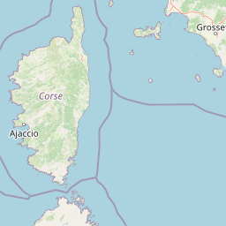
Geographic Location of Arcipelago di La Maddalena National Park in Italy
Arcipelago di La Maddalena National Park is situated in Italy within the Sardinia region. The designated territory covers protected coastal, island, and marine environments managed under national jurisdiction.
- Countries
- Italy
- Regions
- Sardinia
- Primary location
- Italy
- Geographic setting
- Coastal · Island · Marine
Boundary and coordinates
Explore geographic limits and area calculations across 201 square kilometers
Mapping the Boundaries of Arcipelago di La Maddalena National Park
The mapped boundary provides spatial context for the marine and island limits of Arcipelago di La Maddalena National Park. Accompanying metrics detail the estimated total area, center coordinates, and geographic spans.
- Boundary area
- 198.9 km²
- Boundary perimeter
- 105.2 km
- Northernmost point
- 41.3215° N
- Southernmost point
- 41.0519° N
- Easternmost point
- 9.6216° E
- Westernmost point
- 9.3097° E
- Geographic centre
- 41.2208° N, 9.433° E
- North–south span
- 29.9 km
- East–west span
- 26.2 km
Terrain and natural features
Explore recorded lowland terrain and coastal geographic features
Arcipelago di La Maddalena National Park Terrain and Named Features
Stored lowland terrain classifications define the baseline geography across protected coastal zones and island formations. Linked feature cards supply names, types, and spatial relationships for recorded bays, islands, peaks, and beaches.
Selected named natural features
Islands
Berrettini
Bays
Porto Madonna
Bays
Calaccia
Bays
Cala Coticcio
Bays
Cala lunga
Environmental setting
Insular terrain, coastal habitats, and Mediterranean climatic zones
Arcipelago di La Maddalena National Park Environmental Classifications and Setting
Recorded landscape features, coastal habitats, and Mediterranean climate zones frame the physical setting of Arcipelago di La Maddalena National Park. Associated classifications connect recorded environmental categories to relevant protected area destinations within the atlas.
- Relief
- Lowland
- Climate
- Mediterranean
- Water
- Major water bodies
- Forest cover
- Sparse forest
Landscape features
Islands · Coast · Beach
Habitat types
Coastal habitat · Marine habitat
Park atlas
Explore the Diverse Geomarine Protected Landscapes of Sardinia, Corsica, and the Wider Mediterranean
Discover More Protected Areas and National Parks Near Arcipelago di La Maddalena National Park
Continue your park discovery beyond Arcipelago di La Maddalena National Park by exploring other marine and island protected areas across the Mediterranean basin. Compare the distinct geology, coastal ecosystems, and conservation efforts that shape various national parks and protected landscapes in the surrounding region, offering a deeper atlas perspective on Mediterranean biodiversity.
Marine protected areaFrance
Park boundaries overlap#1 closest
North

Sanctuaire Pelagos Marine Protected Area: Mediterranean Geography and Seascape
A transboundary conservation zone spanning 87,500 square kilometers.
Sanctuaire Pelagos represents a unique collaborative effort in marine conservation across the Mediterranean. Spanning the waters between France, Italy, and Monaco, this protected maritime area is defined by its deep-sea canyons and nutrient-rich currents that sustain diverse cetacean populations. Its immense scale and international governance make it a focal point for understanding Mediterranean marine biodiversity and environmental policy.
- Area
- 87,500 km²
- Established
- 1999
- IUCN
- IV
- Relief
- Lowland

National parkSardinia
82 km away#2 closest
West

Asinara National Park: National Park Protected Landscape and Geographic Setting
Explore mapped terrain and protected area context within Sardinia.
Asinara National Park stands as a key protected landscape within the Italian national park system, located off the coast of Sardinia. This entry provides detailed geographic context, focusing on its mapped boundaries and the unique natural terrain that defines this island sanctuary. MoriAtlas facilitates a structured discovery of Asinara National Park, enabling users to understand its protected area status and its significant position within the broader regional geography of Sardinia for atlas exploration.
- Area
- 51.7 km²
- Established
- 1997
- IUCN
- II
- Relief
- Mixed relief

National parkItaly
About 120 km away#3 closest
South
National Park of the Gulf of Orosei and Gennargentu: Italy's Coastal and Mountain Protected Terrain
Mapped geography of a unique Sardinian protected landscape.
Delve into the atlas-level details of the National Park of the Gulf of Orosei and Gennargentu, a protected area in Italy renowned for its stark contrast between dramatic coastal cliffs bordering the Gulf of Orosei and the wild, mountainous interior of the Gennargentu massif. This page provides structured geographic context, mapping the park's boundaries and showcasing its distinctive karst landscape, hidden beaches, and rugged peaks for comprehensive protected-area exploration.
- IUCN
- II
National parkTuscany
128 km away#4 closest
Northeast
Arcipelago Toscano National Park: Protected Islands and Mediterranean Landscape Atlas
Explore Tuscany's unique archipelago geography and protected natural terrain.
Arcipelago Toscano National Park offers a unique perspective on Mediterranean island ecosystems through its comprehensive atlas and mapped landscape context. Covering seven main islands and surrounding marine areas off the coast of Tuscany, this park protects dramatic granite cliffs, endemic flora, and vital habitats for marine and avian life. Understand its geographic scope, protected boundaries, and the distinctive natural terrain that defines this significant Italian conservation landscape.
- Area
- 746.63 km²
- Established
- 1996
- IUCN
- II
- Relief
- Mixed relief
Biosphere reserveCorse
About 139 km away#5 closest
Northwest
Vallée du Fango Biosphere Reserve: Geography and Protected Landscape Analysis
Mapping the natural features of the Corse watershed.
Vallée du Fango encompasses a significant protected watershed in western Corse. This reserve features a complete altitudinal gradient, ranging from Laricio pine-forested summits to a thriving coastal estuary. The site is characterized by exceptionally clear water, centuries-old holm oak woodland, and complex riparian systems that define the natural geography of this Mediterranean drainage basin.
- Area
- 251.1 km²
- Established
- 1977
- Relief
- Mountain
- Climate
- Mediterranean
Protected areaSardegna
About 173 km away#6 closest
Southwest
Stagno di San Giovanni: Protected Coastal Wetland Geography and Regional Landscape Atlas
Brackish lagoon habitats in the province of Oristano, Sardegna
Explore the natural terrain of Stagno di San Giovanni, a brackish coastal lagoon in southwestern Sardegna. Defined by shallow waters and river-fed marshlands, this protected area is central to an interconnected network of Mediterranean lagoons, offering significant insight into the coastal geography and environmental history of the Oristano region.
- Area
- 7 km²
- Relief
- Lowland
- Scope
- Terrestrial
- Water
- Water-dominated
Protected areaSardinia
About 173 km away#7 closest
Southwest
Laguna di Marceddì Protected Area: Sardinia Coastal Geography and Wetland Mapping
A Ramsar-listed brackish wetland on the Sardinian coast
Laguna di Marceddì serves as a critical protected area along the western Mediterranean coast of Sardinia. The landscape features a complex mosaic of tidal channels, shallow pools, and brackish basins. Fed by inland streams, this wetland supports diverse waterbird populations and long-standing professional fisheries while remaining a distinct, low-lying geographic feature within the surrounding agricultural plains of the Oristano province.
- Area
- 9 km²
- Relief
- Lowland
- Scope
- Mixed
- Water
- Water-dominated
National parkItaly
272 km away#8 closest
East
Circeo National Park: Protected Landscape of Italy's Lazio Coast
Explore mapped terrain and Mediterranean ecosystem boundaries.
Circeo National Park offers a distinct protected landscape anchored by the striking Monte Circeo limestone promontory and its associated coastal dunes and island environments. As one of Italy's earliest national parks, it preserves a vital mosaic of Mediterranean ecosystems, providing a unique subject for geographic study and atlas-based navigation of protected areas. Users can explore its mapped context and the interplay between karst geology, coastal terrain, and diverse natural habitats.
- IUCN
- II
MoriAtlas Explorer
Continue Exploring the Arcipelago di La Maddalena National Park's Geographic Identity
Deepen your understanding of Arcipelago di La Maddalena National Park by exploring its precise geographic setting and mapped protected landscape features. This national park offers a rich foundation for regional atlas discovery, allowing for detailed examination of its natural terrain and boundaries. Continue to navigate its unique position within the broader geographic context to enhance your structured exploration of protected areas.
Browse next
Global natural geography
Explore related park routes
Explore MoriAtlas Global ParksBrowse All MoriAtlas ParksGlobal Park Map DiscoveryMoriAtlas: Browse All CountriesBrowse All MoriAtlas ContinentsNational Park Environment AtlasGrand Canyon National Park AtlasYellowstone National Park AtlasYosemite National Park Atlas and GeographySerengeti National Park AtlasGalápagos National Park Protected LandscapeBanff National Park Geography and AtlasKruger National Park Atlas EntryUluṟu-Kata Tjuṯa National Park AtlasExplore Uluru-Kata Tjuta National Park GeographyPlitvice Lakes National Park AtlasFiordland National Park Protected LandscapeGreat Smoky Mountains National Park AtlasAfghanistan National Parks and Protected AreasAlbania National Parks and Protected AreasAlgeria National Parks and Protected AreasAmerican Samoa National Parks and Protected AreasAndorra National Parks and Protected AreasAngola National Parks and Protected AreasAntarctica National Parks and Protected AreasAntigua and Barbuda Park List