
Mori Atlas logo
Wildlife reserveÁrea de protección de flora y fauna Balandra

Explore the unique mangrove lagoon systems and arid desert landscapes along the Gulf of California coastline

Área de protección de flora y fauna Balandra: Protected Coastal Wetlands and Wildlife Reserve Geography

(Área de Protección de Flora y Fauna Balandra)

Área de protección de flora y fauna Balandra stands as a federally protected wildlife reserve located on the coast of Baja California Sur near La Paz. This protected area encompasses approximately 2,500 hectares, defined by a complex interplay of white sand beaches, shallow turquoise coastal lagoons, and expansive mangrove stands. The terrain transitions from these sensitive wetland environments into the arid, desert-adapted flora characteristic of the southern Baja California Peninsula, providing a vital habitat for diverse species within the Gulf of California region.

coastal wetlandmangrove lagoongulf of californiabaja california surprotected natural areawhite sand beach
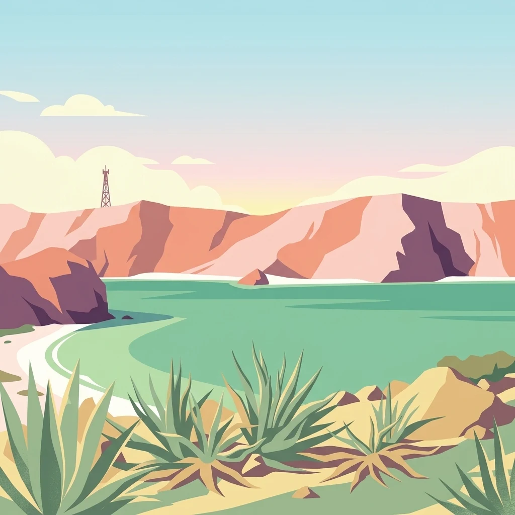
A stylized digital illustration of a coastal bay with turquoise water, rocky cliffs in the background, and agave plants in the foreground.

Área de protección de flora y fauna Balandra

Wildlife reserve

Park overview

Structured park overview, official facts, and landscape profile for Balandra Flora and Fauna Protection Area

Balandra Flora and Fauna Protection Area park facts, protected area profile, and essential visitor context

Review the core facts for Balandra Flora and Fauna Protection Area, including designation, size, terrain, visitor scale, habitats, and operating context in one park-focused overview.

About Balandra Flora and Fauna Protection Area

The Balandra Flora and Fauna Protection Area, or Área de Protección de Flora y Fauna Balandra, is a coastal natural protected area in northwestern Mexico, situated on the shoreline of the Gulf of California within the municipality of La Paz in Baja California Sur. Created in late 2012 as a federal protected area, it represents one of the region's most representative examples of an intact coastal wetland ecosystem, combining beaches, mangrove-fringed lagoons, and the transition zones where arid Baja California vegetation meets marine influence.

Balandra's identity is shaped by its position on the southern Gulf of California, an area long recognized for its biodiversity and for the convergence of tropical marine ecosystems with desert and semi-desert environments. The protected area captures a particularly concentrated version of that convergence. Visitors and researchers encounter three mangrove species (red mangrove, white mangrove, and black mangrove) growing along the edges of a sheltered coastal lagoon, white sand beaches, and rocky points. Inland, the influence of the Sonoran-type landscape becomes apparent in the presence of ironwood trees and protected cactus species such as the Biznaga de Evermann.

Beyond its scenic qualities, Balandra is significant for its place within the broader "Islands and Protected Areas of the Gulf of California" UNESCO World Heritage Site. This inclusion places the reserve in a group of natural areas valued globally for their marine and coastal biological richness. The protected area hosts more than 800 recorded plant and animal species, of which a meaningful share is recognized by Mexican ecological standards as being at some level of conservation concern, highlighting the area's importance as a refuge of coastal biodiversity.

For both local residents of La Paz and travelers exploring the Baja California peninsula, Balandra represents an accessible yet protected coastal landscape where the region's ecological identity, from mangrove wetlands to arid coastal flora, can be observed within a single compact protected area.

Quick facts and research context for Balandra Flora and Fauna Protection Area

Balandra is a federally protected flora and fauna area established by presidential decree on November 30, 2012. It is administered by Mexico's National Commission of Natural Protected Areas and is located in the municipality of La Paz, Baja California Sur, very close to the city of La Paz along the Gulf of California.

The protected area forms part of the UNESCO World Heritage designation "Islands and Protected Areas of the Gulf of California," confirming its international conservation significance. Its environmental profile is dominated by mangrove wetlands, sandy beaches, and coastal lagoons, with more than 800 recorded plant and animal species, including mangrove red, white, and black species, threatened reptiles, and raptors such as the bald eagle, golden eagle, and peregrine falcon.

Protection and recognition

Documented management scope, designation year, and official recognition records

Área de protección de flora y fauna Balandra Protection Status and Designation History

Historical records establish the official designation year as 2012 alongside a mixed protection scope for Área de protección de flora y fauna Balandra. Fact verification details document the conservation status and formal recognition framework without international sources.

Protection details

Protection scope
Mixed
Designated year
2012
Transboundary protection
No
Park context

Deeper park guide and search-rich context for Balandra Flora and Fauna Protection Area

Balandra Flora and Fauna Protection Area history, landscape, wildlife, and travel context

Explore Balandra Flora and Fauna Protection Area through its history, landscape character, ecosystems, wildlife, conservation priorities, cultural context, and seasonal travel timing in a structured park guide built for atlas discovery and search intent.

Why Balandra Flora and Fauna Protection Area stands out

Balandra is best known for its striking coastal wetland landscape, where white-sand beaches and shallow turquoise bays meet one of the most intact mangrove lagoon systems on the southern Gulf of California. The interplay of mangrove, beach, lagoon, and adjacent arid coastal scrub creates a compact but ecologically rich environment for which the area is widely recognized. The reserve is also notable for its inclusion in the UNESCO "Islands and Protected Areas of the Gulf of California" World Heritage Site, placing it among Mexico's most internationally recognized coastal natural areas. The area is celebrated for its biodiversity, with over 800 recorded species and a notable concentration of protected and threatened wildlife, including endemic reptiles and large raptors.
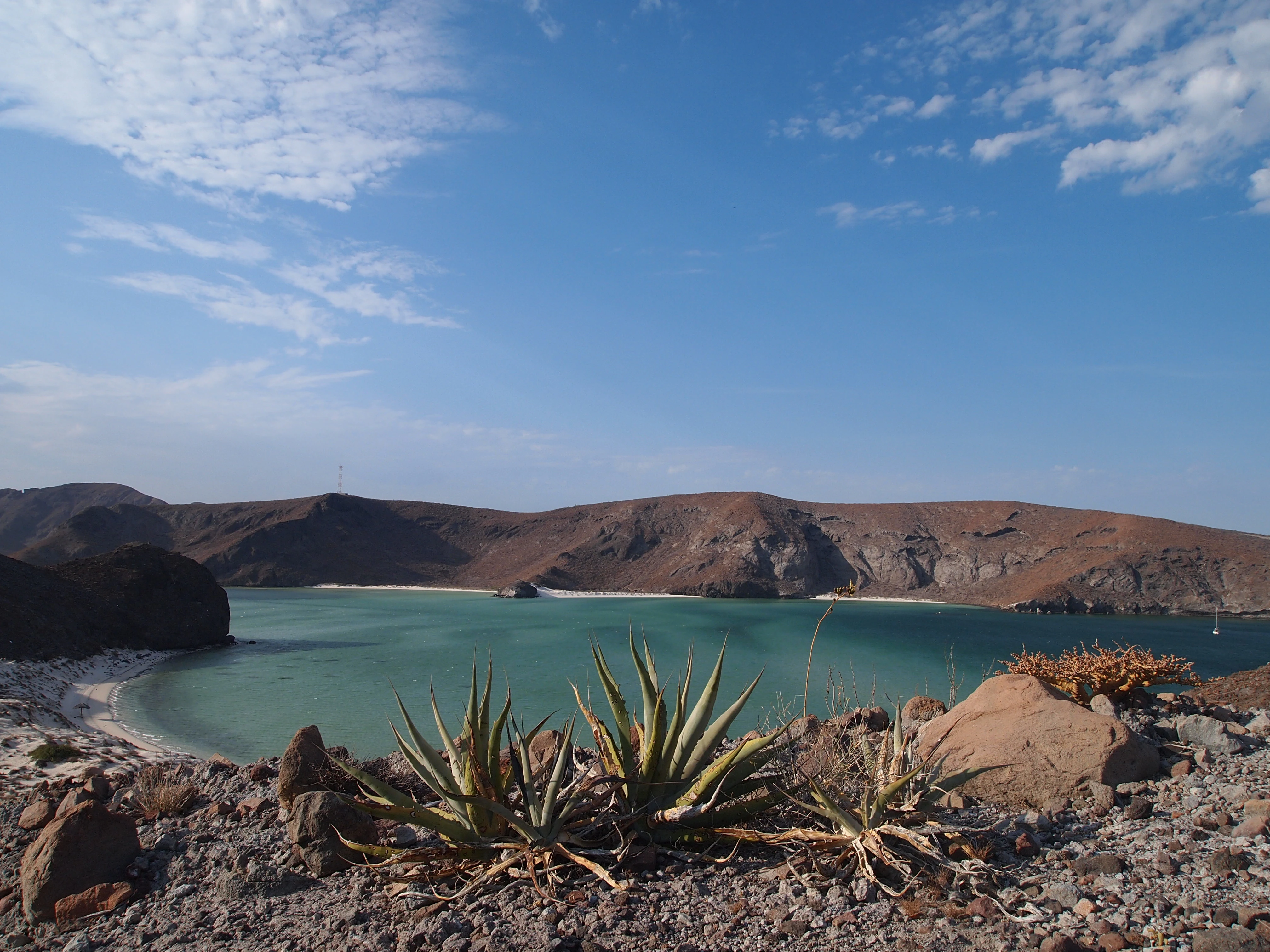
A wide angle view of a turquoise lagoon surrounded by rocky, barren hills under a clear blue sky, with agave plants in the foreground.
A view overlooking the calm, turquoise waters and sandy shores of Playa Balandra, framed by desert vegetation.

Balandra Flora and Fauna Protection Area history and protected-area timeline

Although the Balandra area is now primarily recognized for its ecological value, it has a long and layered human history. Archaeological evidence indicates human presence in the region for over two thousand years, with the southern end of the Baja California peninsula having been home to indigenous groups including the Pericú. The Pericú survived through hunting, fishing, and gathering in this challenging environment, and the calm waters of the Balandra bay made it a focal point for their seasonal fishing and settlement activities. As a coastal society, they depended heavily on the lagoon, beaches, and nearshore waters.

Indirect evidence of even more ancient human arrival suggests that nomadic subsistence-economy groups may have reached the peninsula along the Pacific coast as far back as fourteen thousand years ago, although the formally documented in-place habitation in the Balandra region dates to the later pre-Hispanic period. Over time, the Pericú population declined, with the group effectively disappearing as a distinct culture by the second half of the eighteenth century, largely in connection with the broader consequences of European contact and colonization in the region.

Spanish colonization began in the sixteenth century with the founding of La Paz (originally named Santa Cruz). For centuries afterward, Balandra remained a relatively quiet coastal inlet within the greater La Paz surroundings, valued locally for its scenic character. In the modern era, awareness of its ecological importance grew, and on November 30, 2012, Mexican President Felipe Calderón Hinojosa signed the decree formally establishing the Balandra Flora and Fauna Protection Area. The decree emphasized the area's exceptional richness of flora and fauna and integrated Balandra into Mexico's federal system of natural protected areas, while also aligning it with international recognition through its inclusion in the Gulf of California UNESCO World Heritage complex.

Balandra Flora and Fauna Protection Area landscape and geographic character

The landscape of Balandra is defined by the meeting of land and sea along the southern Gulf of California coastline. Sheltered bays, white-sand beaches, and small rocky headlands create a gently varied coastal topography. The most striking feature of the area is the Balandra coastal lagoon, a shallow, mangrove-lined body of water set behind a barrier of dunes and beaches that protects it from direct wave action. The interplay between open beach, calm lagoon, and tidal channels shapes the visual identity of the protected area.

Behind the immediate shoreline, the coastal terrain transitions quickly into the more arid character typical of the southern Baja peninsula. Low scrubby vegetation, sandy flats, and patches of desert-adapted flora become visible, while elevated viewpoints reveal the broader context of a Gulf coastline backed by the rolling hills and arroyos of the surrounding region. Rocky outcrops and small islets dot the nearshore waters, contributing to the scenic diversity of the bay.

The overall impression of Balandra's landscape is one of compact ecological layering. Beach, lagoon, mangrove forest, coastal scrub, and arid interior habitat exist in close proximity, producing a unified yet varied natural setting. This density and variety of coastal landforms, combined with the protected status of the area, is what makes Balandra stand out within the broader southern Gulf of California coastal environment.

Balandra Flora and Fauna Protection Area ecosystems, habitats, and plant life

The ecological identity of Balandra rests on its wetland and coastal vegetation, which forms the structural backbone of the protected area's habitats. Mangroves dominate the edges of the coastal lagoon and tidal channels. Three mangrove species coexist here: the red mangrove (Rhizophora mangle), the white mangrove (Laguncularia racemosa), and the black mangrove (Avicennia germinans). These mangroves, together with associated microalgae found in the lagoons and adjacent waters, support a highly productive brackish and marine ecosystem.

Beyond the mangrove zone, the ecological profile shifts toward the arid and semi-arid coastal flora typical of the southern Baja peninsula. Ironwood (Olneya tesota) and the Biznaga de Evermann (Mammillaria evermanniana) are characteristic inland species, both of which are recognized by Mexican authorities as having special protection status. Together, these plant communities represent the transition from coastal wetland to desert coastal ecosystem that defines the area's broader ecological setting.

The habitats present in Balandra collectively support the recorded presence of over 800 plant and animal species. This rich biodiversity, combined with the compact size of the protected area and the inclusion of mangroves, beaches, lagoons, and arid scrub, makes Balandra an unusually concentrated example of the ecological diversity of the southern Gulf of California.

Balandra Flora and Fauna Protection Area wildlife and species highlights

Balandra's wildlife is shaped by the proximity of marine, wetland, and arid terrestrial environments. Reptiles occupy a prominent place in the fauna of the protected area. The boa solocuate (Charina trivirgata), the rattlesnake Crotalus enyo, and the western banded gecko (Coleonyx variegatus) all occur here and are recognized as threatened under Mexican ecological standards.

Birdlife is also a defining feature of the reserve. The mangroves and lagoon provide habitat and feeding areas for species such as the Cooper's hawk (Accipiter cooperii), the sharp-shinned hawk (Accipiter striatus), the zone-tailed hawk (Buteo albonotatus), the great horned owl (Bubo virginianus), and the western flycatcher (Empidonax difficilis). Larger raptors are also recorded in the area, including the bald eagle (Haliaeetus leucocephalus), the golden eagle (Aquila chrysaetos), the peregrine falcon (Falco peregrinus), and the prairie falcon (Falco mexicanus), many of which are listed as threatened and some of which are of high regional conservation interest.

Small mammals are present as well, including the Merriam's kangaroo rat (Dipodomys merriami), a characteristic rodent of the arid Baja landscapes. The combination of threatened reptiles, important raptor populations, and small mammals adapted to the arid coastal environment gives Balandra a wildlife profile that is distinctive for such a compact coastal protected area, with more than 800 species overall recorded by Mexico's National Commission for the Knowledge and Use of Biodiversity.

Balandra Flora and Fauna Protection Area conservation status and protection priorities

Balandra carries substantial conservation significance due to both its ecological composition and its formal recognition at the international level. The protected area's mangrove lagoon is one of the key coastal wetland features of the region's southern Gulf of California coastline. The presence of three mangrove species, combined with adjacent beaches, tidal channels, and arid scrub habitats, makes the area a focus for the conservation of the broader coastal ecosystem that sustains the Gulf of California.

Recognition of Balandra's importance is partly formal: it is included as a component of the UNESCO World Heritage Site "Islands and Protected Areas of the Gulf of California," placing it in a globally recognized framework of marine and coastal conservation. At the national level, it was declared a federal flora and fauna protection area in 2012, integrating it into Mexico's national system of natural protected areas administered by the National Commission of Natural Protected Areas (CONANP).

The area's biodiversity data further underline its conservation value. National databases record more than 809 species of plants and animals within Balandra, of which more than 30 fall within some category of risk according to the Mexican official standard NOM-059, and 11 are classified as exotic species. The combination of mangrove ecosystems, native coastal flora under special protection, and threatened wildlife, including endemic reptiles and large raptors, establishes Balandra as a meaningful site for the conservation of both regional and Gulf-wide biodiversity.

Balandra Flora and Fauna Protection Area cultural meaning and human context

Balandra carries a deep human and cultural layer that extends back more than two thousand years of documented habitation, with even older potential migration into the Baja peninsula along the Pacific coast. The bay was historically a focal point of indigenous Pericú settlement, supporting fishing and gathering activities tied directly to the lagoon's productivity. As a result, Balandra is closely linked to the broader story of the indigenous groups of southern Baja California and their adaptation to one of the most demanding environments in Mexico.

The Spanish arrival in the sixteenth century, marked by the founding of La Paz, transformed the regional cultural landscape. The original natural setting of Balandra persisted, but the area gradually became part of the cultural geography of a Spanish-founded regional capital. In the modern era, Balandra holds cultural meaning for residents of La Paz and visitors alike as a place of natural and historical importance, often referenced alongside the broader heritage of the Gulf of California coast. The coexistence of long indigenous heritage with more recent Mexican national identity, including modern federal conservation action, gives the protected area a layered cultural dimension.

Top sights and standout views in Balandra Flora and Fauna Protection Area

Balandra stands out for the rare combination of three coexisting mangrove species along a single sheltered coastal lagoon. This mangrove diversity, paired with adjacent sandy beaches, makes the protected area an unusually compact coastal ecosystem. The broader inclusion of the site in the Gulf of California UNESCO World Heritage complex raises its profile as a natural area of international importance.

The reserve is also distinguished by the number of species recorded in a relatively small space: more than 800 plant and animal species, including over 30 species officially listed as threatened. Coupled with the documented archaeological heritage of the Pericú and the visual appeal of the bay, Balandra offers both biodiversity and cultural depth within a relatively accessible protected area near La Paz.

Best time to visit Balandra Flora and Fauna Protection Area

Balandra's character shifts meaningfully with the seasons of Baja California Sur. The dry, mild months typical of late autumn, winter, and early spring tend to offer clearer skies, calmer sea conditions, and comfortable temperatures, making this period widely regarded as the most pleasant for experiencing the beach and lagoon scenery in its calmest form.

In the warmer months, the heat can be more intense, and tropical storm activity occasionally affects the Gulf coast, but the area remains ecologically active year-round, with mangrove wildlife, birdlife, and reptiles continuously present regardless of season. The transitional shoulder periods often combine pleasant weather with active ecological conditions, providing opportunities to observe the area's biodiversity in a comfortable setting.

Monthly climate preview

Long-term representative monthly temperature and precipitation patterns across the protected landscape

Área de protección de flora y fauna Balandra Climate and Average Temperature Normals

Representative coordinates record measured multi-year temperature ranges alongside low daily precipitation rates across the landscape. Examining the full monthly climate normals clarifies ongoing annual patterns and multi-year environmental baselines.
Annual mean25 °C
19 °C30 °C
Jan19°
Feb19°
Mar21°
Apr23°
May25°
Jun28°
Jul30°
Aug30°
Sep29°
Oct27°
Nov24°
Dec20°
Warmest month
August

30 °C

Coolest month
January

19 °C

Wettest month
September

2.6 mm/day

Driest month
April

0 mm/day

Park location guide

Geography guide, regional context, and park location map for Balandra Flora and Fauna Protection Area

Balandra Flora and Fauna Protection Area park geography, regions, and map view in Mexico

Understand where Balandra Flora and Fauna Protection Area sits in Mexico through a broader geographic reading of the surrounding landscape, nearby location context, and its mapped position within the national park landscape.

How Balandra Flora and Fauna Protection Area fits into Mexico

Mexico, officially the United Mexican States, is a country in North America spanning the Sierra Madre mountain ranges, coastal plains, and tropical regions. It borders the United States to the north, Guatemala and Belize to the southeast, and has coastlines along the Pacific Ocean, Gulf of Mexico, and Caribbean Sea. With a population exceeding 130 million, Mexico is home to one of the world's most significant concentrations of Indigenous languages alongside Spanish.

Wider geography shaping Balandra Flora and Fauna Protection Area in Mexico

Mexico occupies a land area of 1,972,550 km2, making it the thirteenth-largest country in the world. The terrain is highly diverse, featuring the Sierra Madre Occidental and Sierra Madre Oriental mountain ranges, the Mexican Plateau, coastal lowlands along the Pacific and Gulf/Caribbean margins, and the Yucatan Peninsula. The country spans multiple climate zones from desert in the north to tropical rainforest in the south.

Map view of Balandra Flora and Fauna Protection Area

Use this park location map to pinpoint Balandra Flora and Fauna Protection Area in Mexico, understand its exact geographic position, and read its mapped placement within the surrounding landscape more clearly.

Pigeon | © OpenStreetMap contributors

Location context for Balandra Flora and Fauna Protection Area

Baja California Sur

Visual reference of coastal lagoons, mangrove stands, and arid Baja terrain.

Área de protección de flora y fauna Balandra Photos, Scenery, and Landscapes

Visual documentation of Área de protección de flora y fauna Balandra reveals the complex interplay between calm turquoise bays, sheltered mangrove lagoons, and arid coastal scrub. Examining these protected habitats provides a deeper understanding of the distinct geomorphology and fragile ecological balance defining the Gulf of California coastline.

A wide angle view of a turquoise lagoon surrounded by rocky, barren hills under a clear blue sky, with agave plants in the foreground.

Park atlas

Discover adjacent protected landscapes and coastal reserves across the surrounding region

Parks Near Área de Protección de Flora y Fauna Balandra for Regional Comparison

Browse other protected areas and coastal reserves situated near Área de Protección de Flora y Fauna Balandra to compare regional ecosystems. Exploring adjacent park geography provides a broader understanding of the wider Gulf of California natural landscape.
A watercolor painting showing a coastal scene with low-lying green hills in the midground, a strip of water in the foreground, and distant purple-hued mountains under a pale yellow sky.
Protected areaBaja California Sur
About 17 km away#1 closest

South

El Mogote Protected Area: Coastal Geography and Wetland Mapping in Baja California Sur

Sand barriers, mangrove fringes, and arid dune systems.

El Mogote is a defining landform of the Bay of La Paz, showcasing the intersection of extreme arid environments and sheltered estuarine habitats. This protected area provides a distinct study of coastal morphology, where wind-driven dunes meet the quiet, vital channels of a Ramsar-recognized wetland system that sustains regional marine health.

Established
2008
Relief
Lowland
Climate
Arid
Access
Moderate access
A watercolor painting of a mountain landscape with soft green hills and a tall desert plant in the foreground.
Biosphere reserveBaja California Sur
About 48 km away#2 closest

South

Sierra La Laguna Biosphere Reserve: Mapping the Highest Range in Baja California Sur

Highland geography and protected ecological terrain

Sierra La Laguna represents a singular protected landscape in Baja California Sur, characterized by high-elevation pine-oak forests and granite massifs. Its rugged topography and distinct microclimates support a dense concentration of endemic species while serving as the principal aquifer recharge zone for the southern peninsula region.

Area
1,124.37 km²
Established
1994
Relief
Mountain
Climate
Subtropical
National parkBaja California Sur
About 134 km away#3 closest

Southeast

Cabo Pulmo National Park: National Park Atlas and Protected Landscape Discovery

Explore its mapped geographic boundaries and regional context.

Cabo Pulmo National Park represents a vital protected natural landscape offering unique atlas exploration opportunities. Understand its specific geographic placement within Baja California Sur and explore its mapped boundaries as a national park. This destination provides a focused look at protected natural areas and their significance in regional geography.

Area
71.11 km²
Established
1995
IUCN
II
Relief
Lowland
National parkBaja California Sur
About 190 km away#4 closest

Northwest

Bahía de Loreto National Park: National Park Protected Landscape and Geographic Identity

Explore its mapped boundaries and regional context.

Bahía de Loreto National Park offers a distinct focus on its protected natural landscape and geographic features within Baja California Sur. This destination provides detailed mapping and regional context, enabling a focused exploration of its boundaries and natural environment. It is ideal for users seeking to understand the specific protected area identity and its geographical placement as part of a broader atlas of conservation landscapes.

Area
2,065.81 km²
Established
1996
IUCN
II
Relief
Mixed relief
Regional parkSinaloa
About 349 km away#5 closest

East

Ceuta Regional Park: Coastal Geography and Protected Nesting Habitats in Sinaloa

Coastal protection and agricultural valley landscape analysis.

Ceuta Regional Park stands as a key protected area on the Sinaloa coast of Mexico, noted for its long-standing sea turtle conservation initiatives and importance to migratory shorebirds. The park geography spans low-lying coastal plains and beach environments, framed by the agricultural heart of the Elota municipality. This entry provides a structural overview of the terrain, boundaries, and ecological context defining this coastal reserve.

Area
15 km²
Established
2002
Relief
Lowland
Access
Access unknown
Protected areaSonora
About 352 km away#6 closest

Northeast

Área de protección de flora y fauna Sierra de Álamos-Río Cuchujaqui: Geography and Park Boundaries

Detailed atlas view of the Sonora biodiversity enclave and canyon systems.

Spanning over 92,000 hectares in Sonora, this protected area is defined by its dramatic transition from coastal plains to the Sierra Madre range. The geography centers on the deep, moisture-trapping barrancas of the Cuchujaqui River, which sustain a rare mixture of Neotropical and temperate species. Examine the structural complexity of these forested slopes and river-carved valleys that function as a essential habitat for large predators and diverse flora alike.

Area
928.9 km²
Established
1996
A soft watercolor illustration of rolling green hills, distant purple mountains, and stylized trees.
Protected areaChihuahua
About 378 km away#7 closest

Northeast

Cerro Mohinora: Protected Volcanic Summit and Alpine Geography in Chihuahua

An analysis of volcanic terrain and high-elevation protected ecosystems.

Cerro Mohinora dominates the skyline as a prominent volcanic landmark within the Sierra Madre Occidental. This record details the protected area's geographic reach, examining its complex igneous history and the dramatic vertical transition from pine-covered slopes to its snowy summit, offering a clear map-oriented view of this significant Chihuahua natural landmark.

Established
2012
Relief
Mountain
Water
Minor water
Season
Seasonal
Wildlife reserveSinaloa
About 382 km away#8 closest

East

Meseta de Cacaxtla Flora and Fauna Protection Area: Sinaloa Protected Landscape Overview

Mapping dry forests and Pacific coastal ecosystems

Meseta de Cacaxtla Flora and Fauna Protection Area is a significant wildlife reserve in Sinaloa, characterized by its transition from an elevated inland plateau to a complex coastal fringe of mangroves and lagoons. Spanning 508 square kilometers, this protected area preserves an essential blend of arid tropical ecosystems and marine habitats along the Mexican Pacific coast, providing a clear geographic view of regional conservation efforts.

Area
508.62 km²
Established
2000
IUCN
VI
Relief
Lowland

Common questions about visiting, size, designation, and location context for Balandra Flora and Fauna Protection Area

Balandra Flora and Fauna Protection Area FAQs for park facts, access, geography, and protected area context

Find quick answers about Balandra Flora and Fauna Protection Area, including protected-area facts, park geography, trail and visitor context, and how the park fits into its surrounding country and regional landscape.
MoriAtlas Explorer

Continue Your Protected Areas Search Across the Global Atlas

Deepen your exploration by continuing the structured search for national parks and protected areas worldwide. Utilize the comprehensive filtering capabilities to compare different conservation landscapes and refine your understanding of global park geography. Discover more about the distribution and characteristics of protected natural areas.

Global natural geography