

Mori Atlas logo
Protected areaÁrea de protección de flora y fauna Sierra de Álamos-Río Cuchujaqui

Analyzing the dramatic altitudinal gradients and canyon systems within this Sonoran biodiversity hotspot.

Geographic Overview and Protected Landscape of Área de protección de flora y fauna Sierra de Álamos-Río Cuchujaqui

The Área de protección de flora y fauna Sierra de Álamos-Río Cuchujaqui serves as a vital transition zone between the Sierra Madre Occidental and the Northwest Coastal Plain of Sonora. This protected area encompasses deep barrancas and steep ridges that compress Sinaloan thornscrub, tropical dry deciduous forests, and pine-oak woodlands into a single, cohesive geography. Researchers and enthusiasts can trace how these distinct ecological belts converge along the Cuchujaqui River watershed to form one of the most botanically rich refuges in northern Mexico.

protected natural areaflora and fauna protection areaSierra Madre Occidentaltropical dry forestpine-oak forestSinaloan thornscrub

Área de protección de flora y fauna Sierra de Álamos-Río Cuchujaqui

Protected area

Park overview

Structured park overview, official facts, and landscape profile for Sierra de Álamos-Río Cuchujaqui Flora and Fauna Protection Area

Sierra de Álamos-Río Cuchujaqui Flora and Fauna Protection Area park facts, protected area profile, and essential visitor context

Review the core facts for Sierra de Álamos-Río Cuchujaqui Flora and Fauna Protection Area, including designation, size, terrain, visitor scale, habitats, and operating context in one park-focused overview.

About Sierra de Álamos-Río Cuchujaqui Flora and Fauna Protection Area

The Sierra de Álamos-Río Cuchujaqui Flora and Fauna Protection Area is one of the 42 Areas for the Protection of Flora and Fauna (APFF) recognized in Mexico as of the early 2020s, and one of the most ecologically distinctive within the state of Sonora. Its protection status places it within a federal framework managed by the Comisión Nacional de Áreas Naturales Protegidas (CONANP), which oversees a network of reserves designed not for strict ecological isolation but for the conservation of flora, fauna, and the landscape processes that sustain them. Within this framework, the Sierra de Álamos area safeguards an exceptional intersection of biological provinces and habitat types in a single contiguous territory.

Geographically, the reserve occupies a strategic band of southwestern Sonora, where the Sierra de Álamos runs parallel to the Pacific coast and is deeply incised by canyons draining toward the sea via the Fuerte River system. The Río Cuchujaqui is one of several Pacific-bound tributaries cutting through these mountains; its canyon network defines much of the protected area's topography. The altitudinal gradient from low tropical dry forest up into Sierra Madre pine-oak forest is compressed into a relatively short horizontal distance, which is unusual for northwestern Mexico and gives the area its exceptional species turnover.

The protected area also plays an important role in connecting broader landscape-scale conservation efforts in the southern Sonora and northern Sinaloa corridor, where Sinaloan thornscrub and tropical deciduous forest provide critical habitat for migratory and resident species. By protecting this gradient and its associated watersheds, the reserve helps maintain ecosystem services, including water retention and streamflow regulation in a region where arid and subhumid climates meet. The 2007 inclusion in UNESCO's World Network of Biosphere Reserves reflects this combination of high biodiversity, intact ecological gradients, and potential for sustainable regional development, even though Mexico retains its own domestic designation as an APFF.

Quick facts and research context for Sierra de Álamos-Río Cuchujaqui Flora and Fauna Protection Area

The Sierra de Álamos-Río Cuchujaqui Flora and Fauna Protection Area is located in the municipality of Álamos, in southern Sonora, Mexico, within the Sierra Madre Occidental ecoregion. It was established on 19 July 1996 and covers approximately 92,890 hectares. The area is administered by Mexico's National Commission of Natural Protected Areas (CONANP) and has been part of UNESCO's World Network of Biosphere Reserves since 2007. Its protected status spans an altitudinal gradient from tropical dry deciduous forest in lowland Pacific-facing valleys to pine-oak forests higher in the Sierra de Álamos. The reserve is recorded as hosting more than 2,360 species of plants and animals, including 557 vertebrate species, of which more than 100 fall under some risk category in Mexico's NOM-059.

Park context

Deeper park guide and search-rich context for Sierra de Álamos-Río Cuchujaqui Flora and Fauna Protection Area

Sierra de Álamos-Río Cuchujaqui Flora and Fauna Protection Area history, landscape, wildlife, and travel context

Explore Sierra de Álamos-Río Cuchujaqui Flora and Fauna Protection Area through its history, landscape character, ecosystems, wildlife, conservation priorities, cultural context, and seasonal travel timing in a structured park guide built for atlas discovery and search intent.

Why Sierra de Álamos-Río Cuchujaqui Flora and Fauna Protection Area stands out

The protected area is best known for its remarkable biodiversity concentration, where three major floristic influences meet: Sinaloan thornscrub, tropical dry deciduous forest, and the evergreen pine-oak forests of the Sierra Madre Occidental. This convergence produces an unusually high species count for a single protected landscape in northwestern Mexico. It is also notable for the depth and integrity of its subtropical canyon systems, particularly along the Cuchujaqui River, where steep barrancas shelter relict populations of plants and animals otherwise restricted to more tropical latitudes. The presence of large predators such as jaguar and ocelot, together with characteristic Sonoran wildlife like the Gila monster and the endangered Alamos mud turtle, gives the area strong profile as a refuge for species that depend on intact, structurally complex habitat.

Sierra de Álamos-Río Cuchujaqui Flora and Fauna Protection Area history and protected-area timeline

The Sierra de Álamos-Río Cuchujaqui area received its formal federal protection on 19 July 1996, when it was decreed as an Area for the Protection of Flora and Fauna under Mexican environmental law. The designation placed the territory under the administration of the country's national system of protected natural areas, recognizing the exceptional concentration of biodiversity documented in the municipality of Álamos during preceding decades of biological survey work.

In 2007, the area was admitted into UNESCO's World Network of Biosphere Reserves through the Man and the Biosphere (MaB) Programme, reinforcing its international profile as a site of conservation significance. Although this international designation labels it a biosphere reserve, within Mexico's domestic classification system it retains its original character as a flora and fauna protection area, rather than being redesignated as a national biosphere reserve.

Through these layers of recognition, the protected area's history illustrates how a regionally important biodiversity hotspot in northwestern Mexico gradually acquired both national legal protection and international scientific endorsement, building on earlier botanical and ecological studies that documented the unusually rich flora and fauna of the Sierra de Álamos region.

Sierra de Álamos-Río Cuchujaqui Flora and Fauna Protection Area landscape and geographic character

The landscape of the Sierra de Álamos-Río Cuchujaqui area is defined by a dramatic altitudinal gradient squeezed between the coast and the Sierra Madre Occidental. The Sierra de Álamos itself runs parallel to the Pacific shoreline, and its flanks have been deeply carved by rivers that descend toward the ocean. The result is a landscape of steep ridges, narrow canyons, and broad valley floors, with elevations that climb from warm lowlands suitable for tropical dry forest up to higher montane belts dominated by pine and oak.

The most striking physical features are the deep barrancas formed by rivers such as the Cuchujaqui, a tributary of the Río Fuerte that ultimately reaches the Pacific. These canyons act as natural corridors, concentrating moisture and creating microhabitats that sustain plant and animal communities well removed from their typical ranges. The interplay of canyon, ridge, and plateau gives the protected area much of its visual and ecological character, with abrupt transitions between arid-looking slopes and shaded, forested ravines.

At the broader scale, the reserve sits between two major geographic provinces: the Sierra Madre Occidental to the east and the Northwest Coastal Plain to the west. This transitional position shapes everything from soil patterns to vegetation belts, producing a landscape where tropical, subtropical, and temperate influences visibly interweave over short distances.

Sierra de Álamos-Río Cuchujaqui Flora and Fauna Protection Area ecosystems, habitats, and plant life

Ecologically, the Sierra de Álamos-Río Cuchujaqui area is one of the richest protected natural areas in Sonora, functioning as a meeting point for three distinct vegetation systems. In the lower elevations and on south-facing slopes, Sinaloan thornscrub (matorral espinoso de Sinaloa) mingles with tropical dry deciduous forest, while at higher elevations the evergreen forests of the Sierra Madre, dominated by pine and oak, take over. This compression of multiple biotic communities into a single watershed is rare in northwestern Mexico and is the foundation of the area's biodiversity values.

CONABIO's national biodiversity information system records more than 2,360 species of plants and animals within the protected area, distributed across roughly 1,200 plant species in about 566 genera and 148 families. Around 107 species fall under some category of risk in Mexico's NOM-059 ecological protection list, while approximately 57 species are classified as exotic. The cactus-like Guaiacum coulteri, various Brahea palms, the cycad Dioon tomasellii, and Pacific Magnolia are among the notable plant elements that contribute to its botanical importance.

Vegetation types in the reserve typically include tropical deciduous forest in the warmer lowlands, subtropical thornscrub along the foothills, oak woodland in the transition zones, and pine-oak forest higher up the Sierra de Álamos. The riparian corridors along the Cuchujaqui River and its tributaries add a fourth layer of habitat, with gallery forest and freshwater features that enhance overall ecological complexity.

Sierra de Álamos-Río Cuchujaqui Flora and Fauna Protection Area wildlife and species highlights

More than 557 vertebrate species have been documented within the Sierra de Álamos-Río Cuchujaqui protected area, a figure that places it among the most faunistically rich reserves of its kind in Mexico. This vertebrate diversity spans mammals, birds, reptiles, amphibians, and freshwater species, reflecting the variety of habitats compressed into the reserve's gradients and canyon systems.

Among the most prominent mammals are the jaguar (Panthera onca) and the ocelot (Leopardus), both of which are wide-ranging predators that depend on intact, structurally diverse landscapes for survival. Their continuing presence indicates that the area retains large blocks of suitable habitat and functional prey populations. Other notable mammals include the neotropical river otter (Lontra longicaudis), which is closely tied to the Cuchujaqui River and its tributaries.

Reptile diversity is also significant. The Gila monster (Heloderma suspectum) and its relative Heloderma horridum represent characteristic Sonoran and Sinaloan reptile fauna, while the Alamos mud turtle (Kinosternon alamosae) is a notable endemic of the region's river systems. The avifauna includes the golden eagle (Aquila chrysaetos) at the higher elevations, hummingbirds such as the rufous-tailed Amazilia (Amazilia tzacatl), the great blue heron (Ardea herodias) along the rivers, and the eared quetzal (Euptilotis neoxenus), a striking representative of the mixed pine-oak and humid canyon forests. Freshwater shrimp of the genus Macrobrachium inhabit the river systems, contributing to the aquatic fauna of the Cuchujaqui basin.

Sierra de Álamos-Río Cuchujaqui Flora and Fauna Protection Area conservation status and protection priorities

From a conservation perspective, the Sierra de Álamos-Río Cuchujaqui area safeguards one of the most botanically diverse enclaves in the Mexican state of Sonora, and one of the more important in the country. Its protection is justified by the convergence of three major floristic provinces within a single continuous landscape, including Sinaloan thornscrub, tropical dry deciduous forest, and the evergreen pine-oak forests of the Sierra Madre Occidental. Without federal protection, much of this gradient would be vulnerable to land-use change associated with agriculture, livestock, and forestry pressure in the region.

The area is also nationally and internationally significant for the number of species under formal risk categories. More than 100 species recorded in the reserve fall under some category of protection under Mexico's NOM-059 ecological standards, including iconic vertebrates such as the jaguar and ocelot, as well as range-restricted plants and reptiles such as the cycad Dioon tomasellii and the Alamos mud turtle. The presence of these risk-rated species, together with the structural integrity of the habitat mosaic, gives the reserve a concrete conservation role beyond symbolic designation.

The 2007 inclusion in UNESCO's World Network of Biosphere Reserves adds a further layer of recognition and emphasizes the area's potential to combine biodiversity conservation with sustainable land use and scientific study. As part of Mexico's national APFF network, it is administered under a flexible framework that allows for regulated human activities alongside habitat protection, an approach consistent with biosphere reserve principles worldwide.

Sierra de Álamos-Río Cuchujaqui Flora and Fauna Protection Area cultural meaning and human context

The Sierra de Álamos-Río Cuchujaqui protected area lies within the municipality of Álamos, a historically significant town in southern Sonora that was once an important colonial mining center and remains a recognized Pueblo Mágico for its preserved architecture and regional identity. While the reserve itself is a natural protected area focused on biodiversity, its surrounding cultural landscape has long been shaped by the relationship between human settlements, ranching, and the surrounding sierra and river valleys.

Traditional land uses in the broader region have included cattle ranching, small-scale agriculture, and the harvesting of forest products, all of which interact with the natural systems protected by the reserve. The proximity of the historic town of Álamos also gives the area additional value for cultural tourism, where colonial heritage and protected natural landscapes intersect. Indigenous and mestizo communities of the region have long interacted with the tropical and temperate forests of the Sierra de Álamos, contributing to a layered cultural identity that links the natural protected area with the surrounding human landscape.

Top sights and standout views in Sierra de Álamos-Río Cuchujaqui Flora and Fauna Protection Area

The Sierra de Álamos-Río Cuchujaqui area stands out for combining one of the highest plant species counts in Sonora with a rare triple convergence of Sinaloan thornscrub, tropical dry forest, and Sierra Madre pine-oak forest. The deep barrancas of the Cuchujaqui River compress this ecological richness into canyon habitats that shelter relict populations of warm-adapted species. Its wildlife profile features both large Neotropical predators such as jaguar and ocelot and iconic Sonoran-Sinaloan reptiles such as the Gila monster and the Alamos mud turtle. Internationally, its 2007 inclusion in UNESCO's World Network of Biosphere Reserves enhances the area's standing as a reference site for biodiversity conservation in northwestern Mexico.

Best time to visit Sierra de Álamos-Río Cuchujaqui Flora and Fauna Protection Area

Because the reserve spans a wide altitudinal gradient from warm lowland dry forest to cooler pine-oak highlands, the ideal visiting period depends on what kind of experience is sought. Cooler months, generally from late autumn through early spring, tend to be more comfortable for exploring the canyon systems and pine-oak forest zones, when temperatures at upper elevations are milder. Warmer months highlight the tropical dry forest, which may be leafless and seemingly arid but supports high reptile and bird activity.

Birdwatching and wildlife observation are particularly productive when resident and migratory species are concentrated around available water, especially along the Cuchujaqui River and its tributaries. The contrast between the lush canyon bottoms and the drier surrounding ridges means that seasonal conditions can shift the visual and ecological character of the landscape significantly, rewarding visitors who plan their trip around the habitats they most wish to experience.

Monthly climate preview

Long-term temperature and monthly precipitation averages derived from representative coordinates

Área de protección de flora y fauna Sierra de Álamos-Río Cuchujaqui Climate Normals

Long-term data records reveal distinct seasonal temperature swings and marked precipitation shifts across the representative coordinate. Detailed monthly measurements provide deeper insight into annual averages and long-term climatic norms.
Annual mean23 °C
17 °C30 °C
Jan17°
Feb18°
Mar20°
Apr23°
May27°
Jun30°
Jul28°
Aug27°
Sep26°
Oct25°
Nov21°
Dec17°
Warmest month
June

29.7 °C

Coolest month
January

16.8 °C

Wettest month
July

5.5 mm/day

Driest month
May

0.1 mm/day

Park location guide

Geography guide, regional context, and park location map for Sierra de Álamos-Río Cuchujaqui Flora and Fauna Protection Area

Sierra de Álamos-Río Cuchujaqui Flora and Fauna Protection Area park geography, regions, and map view in Mexico

Understand where Sierra de Álamos-Río Cuchujaqui Flora and Fauna Protection Area sits in Mexico through a broader geographic reading of the surrounding landscape, nearby location context, and its mapped position within the national park landscape.

How Sierra de Álamos-Río Cuchujaqui Flora and Fauna Protection Area fits into Mexico

Mexico, officially the United Mexican States, is a country in North America spanning the Sierra Madre mountain ranges, coastal plains, and tropical regions. It borders the United States to the north, Guatemala and Belize to the southeast, and has coastlines along the Pacific Ocean, Gulf of Mexico, and Caribbean Sea. With a population exceeding 130 million, Mexico is home to one of the world's most significant concentrations of Indigenous languages alongside Spanish.

Wider geography shaping Sierra de Álamos-Río Cuchujaqui Flora and Fauna Protection Area in Mexico

Mexico occupies a land area of 1,972,550 km2, making it the thirteenth-largest country in the world. The terrain is highly diverse, featuring the Sierra Madre Occidental and Sierra Madre Oriental mountain ranges, the Mexican Plateau, coastal lowlands along the Pacific and Gulf/Caribbean margins, and the Yucatan Peninsula. The country spans multiple climate zones from desert in the north to tropical rainforest in the south.

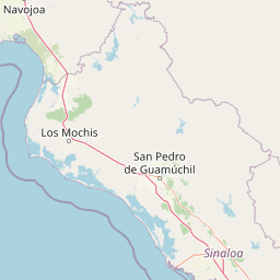
Map view of Sierra de Álamos-Río Cuchujaqui Flora and Fauna Protection Area

Use this park location map to pinpoint Sierra de Álamos-Río Cuchujaqui Flora and Fauna Protection Area in Mexico, understand its exact geographic position, and read its mapped placement within the surrounding landscape more clearly.

Pigeon | © OpenStreetMap contributors

Location context for Sierra de Álamos-Río Cuchujaqui Flora and Fauna Protection Area

Sonora
Park atlas

Compare surrounding protected landscapes and regional conservation areas

Parks Near Área de protección de flora y fauna Sierra de Álamos-Río Cuchujaqui

Browse nearby national parks and connected protected areas sharing the ecological transition zones of northwestern Mexico. Expanding the geographic comparison reveals broader regional terrain patterns and related wildlife habitats.
National parkOcampo Municipality
About 127 km away#1 closest

North

Basaseachic Falls National Park: National Park Geography and Mapped Boundaries

Explore protected lands within Ocampo Municipality.

Basaseachic Falls National Park serves as a key protected area within Ocampo Municipality, Mexico. This page provides detailed geographic information and mapped boundaries, essential for understanding its landscape context and its significance as a national park. Dive into the atlas-style data to appreciate the park's protected terrain and its contribution to the regional geography, offering a factual discovery experience.

Area
58.03 km²
Established
1981
IUCN
II
Relief
Mountain
Wildlife reserveChihuahua
About 155 km away#2 closest

Northeast

Papigochic Flora and Fauna Protection Area: Sierra Madre Occidental Forest Geography

An expansive mountain wildlife reserve in Chihuahua, Mexico.

Spanning over 2,200 square kilometers, this reserve preserves vital pine and oak forest ecosystems in the Sierra Tarahumara. The area is defined by its deep canyons, high-elevation forested ridgelines, and important role in safeguarding temperate montane habitats within northwestern Mexico.

Area
2,227.64 km²
Established
2003
IUCN
VI
Relief
Mountain
Wildlife reserveChihuahua
About 165 km away#3 closest

North

Tutuaca Flora and Fauna Protection Area: Sierra Madre Occidental Mountain Conservation Reserve

Expansive pine-oak forest habitat in Chihuahua, Mexico

Covering over 4,000 square kilometers, the Tutuaca Flora and Fauna Protection Area acts as a critical link in the Sierra Madre Occidental mountain spine. This wildlife reserve preserves dense pine-oak woodlands, rugged canyons, and high-elevation watersheds that characterize the biodiversity of northwestern Mexico. The area plays a vital role in sustainable resource management and habitat connectivity between Chihuahua and neighboring regions.

Area
4,369.86 km²
Established
2001
IUCN
VI
Relief
Mountain
A soft watercolor illustration of rolling green hills, distant purple mountains, and stylized trees.
Protected areaChihuahua
About 181 km away#4 closest

Southeast

Cerro Mohinora: Protected Volcanic Summit and Alpine Geography in Chihuahua

An analysis of volcanic terrain and high-elevation protected ecosystems.

Cerro Mohinora dominates the skyline as a prominent volcanic landmark within the Sierra Madre Occidental. This record details the protected area's geographic reach, examining its complex igneous history and the dramatic vertical transition from pine-covered slopes to its snowy summit, offering a clear map-oriented view of this significant Chihuahua natural landmark.

Established
2012
Relief
Mountain
Water
Minor water
Season
Seasonal
National parkChihuahua
About 278 km away#5 closest

Northeast

Cumbres de Majalca National Park: National Park Discovery and Geographic Context in Chihuahua

Mapped protected landscape exploration in Chihuahua.

Delve into the protected landscape of Cumbres de Majalca National Park, a national park situated in the Chihuahua region of Mexico. This entry provides essential geographic context and details on its mapped boundaries, serving as a key point for atlas-based exploration of Mexico's protected areas. Understand its specific contribution to the regional geography and conservation landscape.

Area
47.72 km²
Established
1939
IUCN
II
Relief
Mountain
Nature reserveSonora
About 282 km away#6 closest

North

Northern Jaguar Reserve: Geography and Protected Landscape Atlas of Sonora

Foothill bushland between the Aros and Bavispe River valleys

Northern Jaguar Reserve represents a key protected block of dry tropical bushland in the Sierra Madre foothills of Sonora. This map-focused profile examines the topography, drainage systems, and structural habitat corridors that support one of the northernmost wild jaguar populations within a transition zone of mountain slopes and river-fed canyons.

Area
222 km²
Relief
Mountain
Climate
Subtropical
Access
Remote access
National parkBaja California Sur
About 295 km away#7 closest

Southwest

Bahía de Loreto National Park: National Park Protected Landscape and Geographic Identity

Explore its mapped boundaries and regional context.

Bahía de Loreto National Park offers a distinct focus on its protected natural landscape and geographic features within Baja California Sur. This destination provides detailed mapping and regional context, enabling a focused exploration of its boundaries and natural environment. It is ideal for users seeking to understand the specific protected area identity and its geographical placement as part of a broader atlas of conservation landscapes.

Area
2,065.81 km²
Established
1996
IUCN
II
Relief
Mixed relief
Wildlife reserveChihuahua
About 324 km away#8 closest

North

Campo Verde Flora and Fauna Protection Area: Atlas and Landscape Discovery in Chihuahua

A significant wildlife reserve in the Sierra Madre Occidental

Spanning the transition from high montane forests to semi arid desert, Campo Verde Flora and Fauna Protection Area represents a core component of Mexico's northern conservation network. Documented for its endemic flora and fauna, this wildlife reserve provides a rare look at the ecological mosaic of the Sierra Madre Occidental region.

Area
1,080.67 km²
Established
1938
IUCN
VI
Relief
Mountain

Common questions about visiting, size, designation, and location context for Sierra de Álamos-Río Cuchujaqui Flora and Fauna Protection Area

Sierra de Álamos-Río Cuchujaqui Flora and Fauna Protection Area FAQs for park facts, access, geography, and protected area context

Find quick answers about Sierra de Álamos-Río Cuchujaqui Flora and Fauna Protection Area, including protected-area facts, park geography, trail and visitor context, and how the park fits into its surrounding country and regional landscape.
MoriAtlas Explorer

Continue Your Protected Areas Search Across the Global Atlas

Deepen your exploration by continuing the structured search for national parks and protected areas worldwide. Utilize the comprehensive filtering capabilities to compare different conservation landscapes and refine your understanding of global park geography. Discover more about the distribution and characteristics of protected natural areas.

Global natural geography