
Mori Atlas logo
Biosphere reserveBahía de los Ángeles Biosphere Reserve

Discover the geographic intersection of arid desert mountains and complex volcanic archipelagos.

Bahía de los Ángeles Biosphere Reserve: Mapped Protected Landscapes of Coastal Baja California

(Reserva de la Biosfera Bahía de los Ángeles)

The Bahía de los Ángeles Biosphere Reserve spans nearly 1,500 square miles of protected coastal and marine territory along the eastern edge of the Baja California Peninsula. This extensive reserve safeguards a unique convergence of rugged desert mountains, sweeping sandy bays, and an archipelago of islands within the highly productive Sea of Cortez. Geographic data reveals complex submarine canyons, tidal channels, and endemic-rich island terrains that distinguish this protected region as a vital ecological corridor in Mexico.

biosphere reservesea of cortezgulf of californiabaja californiacoastal desertislands
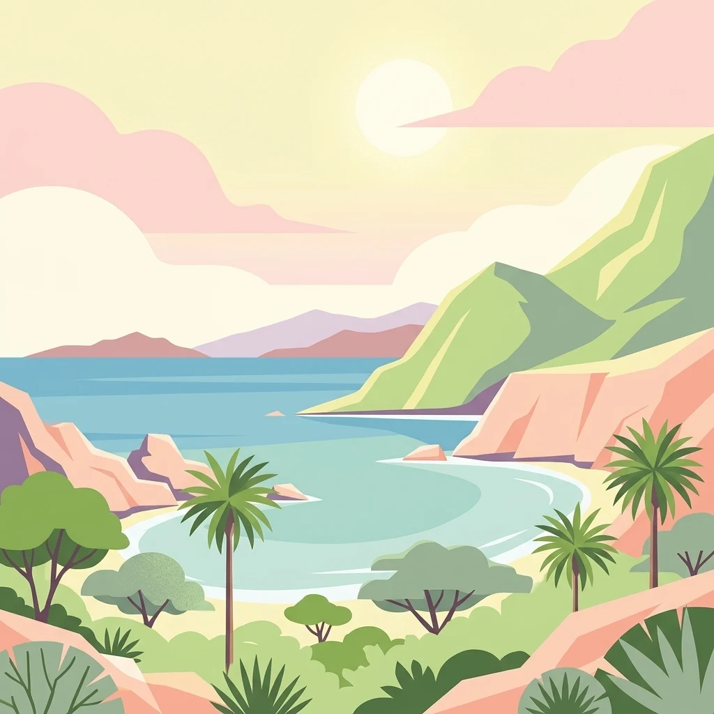
A flat, colorful vector illustration showing a coastal bay with palm trees, scrub vegetation, rocky hills, and a calm sea under a soft sky.

Bahía de los Ángeles Biosphere Reserve

Biosphere reserve

Park overview

Structured park overview, official facts, and landscape profile for Bahía de los Ángeles Biosphere Reserve

Bahía de los Ángeles Biosphere Reserve park facts, protected area profile, and essential visitor context

Review the core facts for Bahía de los Ángeles Biosphere Reserve, including designation, size, terrain, visitor scale, habitats, and operating context in one park-focused overview.

About Bahía de los Ángeles Biosphere Reserve

Bahía de los Ángeles Biosphere Reserve is a protected coastal and marine landscape along the central Gulf of California, on the eastern flank of the Baja California Peninsula. The reserve covers a vast area of roughly 1,500 square miles, extending from the arid shoreline inland to include desert ranges and rugged peninsular terrain, and outward into productive waters dotted with islands, islets, reefs, and submarine canyons.

The defining geographic feature is the bay itself, bounded by Punta la Gringa to the north and Playa Rincón to the south, with the towering Sierra de San Borja rising to the west. Offshore, the second largest island in Mexico, Isla Ángel de la Guarda, dominates the horizon, separated from the mainland and the smaller islands by the Canal de las Ballenas, a deep, current-rich passage known for whale activity. A closer archipelago of about 16 islands and islets, including Coronado (Smith), Calavera, Piojo, Pata, Bota, Jorobado, Flecha, Llave, Cerraja, Ventana, Cabeza de Caballo, and Los Gemelos, lies within sight of the coastal road.

This meeting of desert and sea produces one of the most productive marine ecosystems in the world. Cold, nutrient-rich upwelling along the peninsula's edge feeds dense plankton blooms that, in turn, sustain baitfish, top predators, and seasonal visitors such as whale sharks and migratory whales. The reserve's biological importance has been acknowledged for decades: pioneering oceanographers Jacques Cousteau and journalist Fernando Jordán both explored and described these waters in the mid-twentieth century.

Today the reserve represents a vital conservation anchor in the central Gulf of California, balancing the protection of marine biodiversity, island ecosystems, and desert landscapes with the cultural and economic life of a small coastal community.

Quick facts and research context for Bahía de los Ángeles Biosphere Reserve

The biosphere reserve lies on the central eastern coast of the Baja California Peninsula, within the municipality of San Quintín in the Mexican state of Baja California. It encompasses coastal desert, nearshore waters, two major marine channels, and an archipelago dominated by the large Isla Ángel de la Guarda.

The protected area was formally established on June 5, 2007, as a collaboration among Mexico's National Commission of Natural Protected Areas, the Global Conservation Fund, and partner organizations. Its core conservation targets are the region's endemic island reptiles and its migratory marine fauna, including whale sharks, sea turtles, sea lions, and large whales.

The surrounding district is arid and sparsely populated, with the small fishing and tourist settlement of Bahía de los Ángeles serving as the main gateway. Access is by the Federal Highway 12 branch from Punta Prieta, several hours south of Mexicali and southeast of Tijuana.

Protection and recognition

Documented conservation scope, established designation year, and official recognition records

Bahia de los Angeles Biosphere Reserve Protection Status and Designation History

Bahia de los Angeles Biosphere Reserve maintains a mixed protection scope established through designated records from 2007. Official conservation data compiles management parameters and historical recognition metrics for reliable protected area analysis.

Protection details

Protection scope
Mixed
Designated year
2007
Transboundary protection
No
Park context

Deeper park guide and search-rich context for Bahía de los Ángeles Biosphere Reserve

Bahía de los Ángeles Biosphere Reserve history, landscape, wildlife, and travel context

Explore Bahía de los Ángeles Biosphere Reserve through its history, landscape character, ecosystems, wildlife, conservation priorities, cultural context, and seasonal travel timing in a structured park guide built for atlas discovery and search intent.

Why Bahía de los Ángeles Biosphere Reserve stands out

Bahía de los Ángeles is best known for the seasonal gatherings of whale sharks in its calm coastal waters, where dozens of individuals arrive each summer and can be encountered close to shore. Equally distinctive is the offshore island chain, including the rugged Isla Ángel de la Guarda and smaller islands such as Coronado, Calavera, Piojo, and Cabeza de Caballo, which shelter endemic rattlesnakes and lizards. The reserve is also recognized as one of the Sea of Cortez's most important sea turtle habitats, with long-running research programs dedicated to loggerhead, green, and other nesting and feeding populations. Together, the combination of desert coast, scattered islands, deep submarine canyons, and abundant megafauna gives the reserve a deeply distinctive ecological identity within Mexican protected areas.
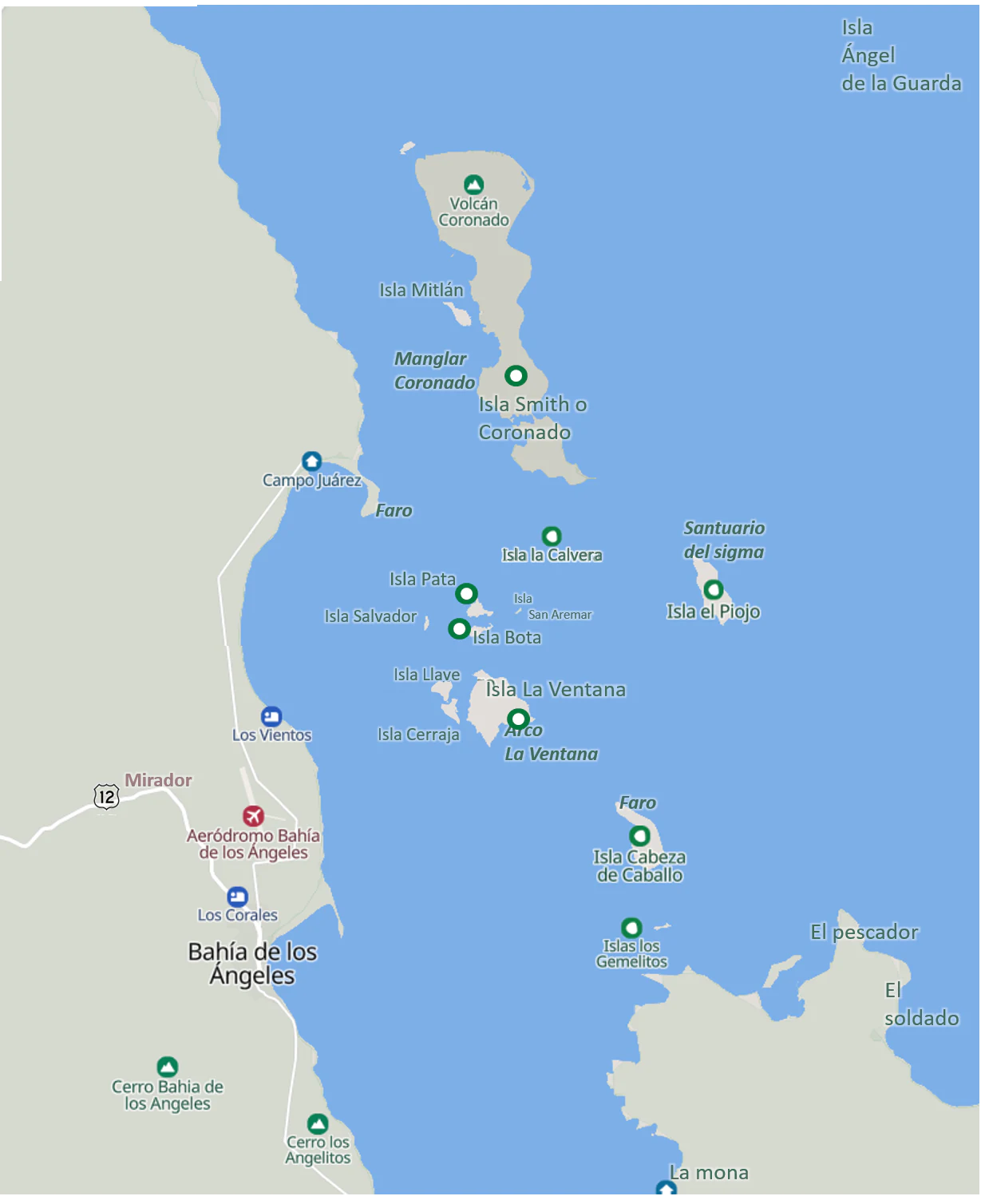
A stylized map showing the coastline of Bahía de los Ángeles and several islands in the Gulf of California, with labels for various islands, geographic points, and an airfield.
Map of the islands, coastline, and landmarks within the Bahía de los Ángeles Biosphere Reserve.

Bahía de los Ángeles Biosphere Reserve history and protected-area timeline

The coastal region of Bahía de los Ángeles was inhabited for millennia by the Cochimí people, who knew the bay and its surroundings by the name Ádac. At the beginning of the seventeenth century, around 3,000 Cochimí are estimated to have lived in this part of central Baja California, drawing on the rich marine resources of the Gulf of California.

The bay entered European records in 1539, when the explorer Francisco de Ulloa, on an expedition financed by Hernán Cortés, became the first European to document it. In 1721, the Jesuit missionary Juan de Ugarte landed here while exploring the gulf, contributing to early debates about the geographic definition of the Island of California. A few decades later, in 1746, the Jesuit Ferdinand Konščak (Fernando Consag) explored the bay, then still known as Bahía de Lobos, and sought a site for a cargo pier that would serve the nearby Misión San Borja Ádac, located about 37 km inland.

In the late nineteenth and early twentieth centuries, the discovery of silver deposits brought a brief mining boom, swelling the local population to around 500 by 1910. Many of today's residents descend from those mining pioneers, though the industry declined after attacks by filibusters and the eventual collapse of the mining economy. The mid-twentieth century brought new attention: in 1951, journalist Fernando Jordán wrote about the area in his widely read work "El otro México," describing Bahía de los Ángeles as a jewel of nature along the otherwise austere Baja California coast.

Modern conservation history began in 1979, when Mexico's Centro Regional de Investigación Pesquera began systematic research and protection of sea turtles in the bay. Marine biologist Antonio Reséndiz established the long-running Campo Archelon research station just north of the town, and in 1995 gained international attention when a loggerhead turtle he had tagged, Adelita, was recovered in Japan, providing the first documented trans-Pacific migration route for the species.

The biosphere reserve itself was formally established on June 5, 2007, through a partnership between Mexico's National Commission of Natural Protected Areas, the Global Conservation Fund, and additional authorities. The designation consolidated decades of local research and community engagement into a single large-scale protection framework for the bay, its islands, and surrounding waters.

Bahía de los Ángeles Biosphere Reserve landscape and geographic character

The reserve's landscape is dominated by the sharp contrast between arid desert and a deeply indented sea coast. The mainland portion consists of rugged Baja California desert terrain, with the Sierra de San Borja to the west shaping local weather and producing sudden, intense warm, dry offshore winds locally called "Westies," which can shift from calm to over 50 knots in minutes.

The bay itself stretches between Punta la Gringa in the north and Playa Rincón in the south, framed by long sandy beaches and rocky headlands. A sand spit called Punta Arenas partly shelters the waterfront of the small fishing settlement, while nearby Puerto Don Juan offers another naturally protected anchorage. Lighthouses at Isla Cabeza de Caballo and the harbor entrance at Punta Arenas underscore the area's long history as a safe harbor for mariners.

Offshore, the archipelago defines the visual identity of the reserve. Isla Ángel de la Guarda, the second largest island in Mexico, rises as a massive arid landmass beyond the Canal de las Ballenas. The nearer chain of islands and islets, including Coronado (locally known as Smith, with a 500 m volcanic cone at its northern end), Calavera, Piojo, Pata, Bota, Jorobado, Flecha, Llave, Cerraja, Ventana, Cabeza de Caballo, and Los Gemelos, scatters across the view from the coastal road and produces the strong currents, eddies, and submarine canyons that drive the bay's exceptional productivity.
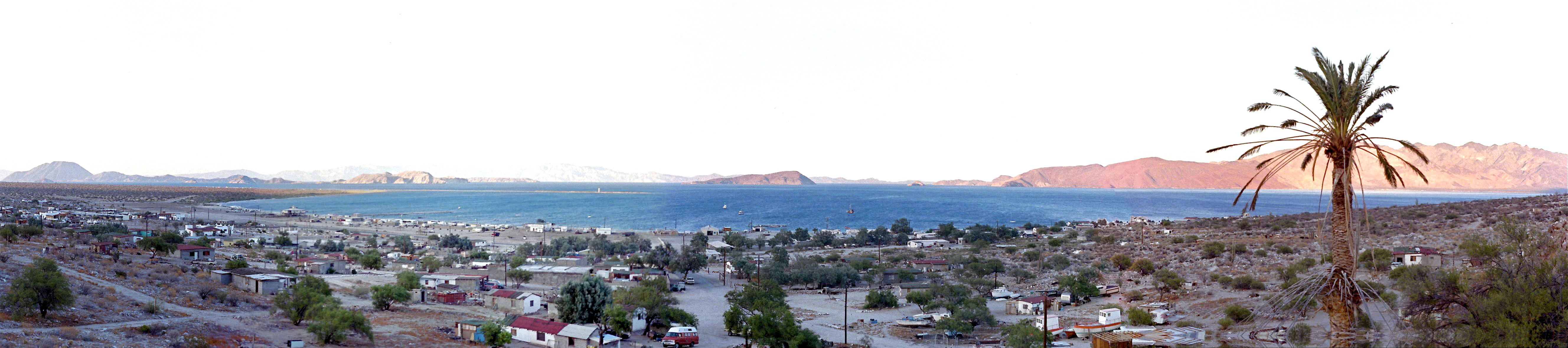
Panoramic landscape view of a coastal town nestled in a desert valley leading to a bay with distant islands under a bright sky.
A wide view overlooking the town and coastal landscape of Bahía de los Ángeles, with arid terrain and islands visible in the distance.

Bahía de los Ángeles Biosphere Reserve ecosystems, habitats, and plant life

The reserve sits at the meeting point of the Sonoran Desert and the Sea of Cortez, two of the most biologically rich environments in North America. On land, the vegetation is sparse and adapted to extreme aridity, dominated by desert scrub, cacti, and dryland shrubs typical of the central Baja California Peninsula. Coastlines alternate between broad sandy beaches, mangrove patches, rocky coves, and volcanic outcrops.

In the waters, the habitat mosaic is extraordinary. Deep submarine canyons and the narrow passages between islands funnel nutrients to the surface, supporting dense plankton communities, schooling baitfish, and the long food chains that depend on them. Coral patches, rocky reefs, and sandy bottoms around the islands provide shelter for groupers, snappers, sierra, bonita, dorado, and other species, while surface waters harbor occasional barracuda and triggerfish.

The archipelago itself is a hotspot of island endemism. Because the islands have long been isolated by strong marine currents and lack of fresh water, several reptile species have evolved there independently, making the islands a focus of conservation attention beyond their marine surroundings.
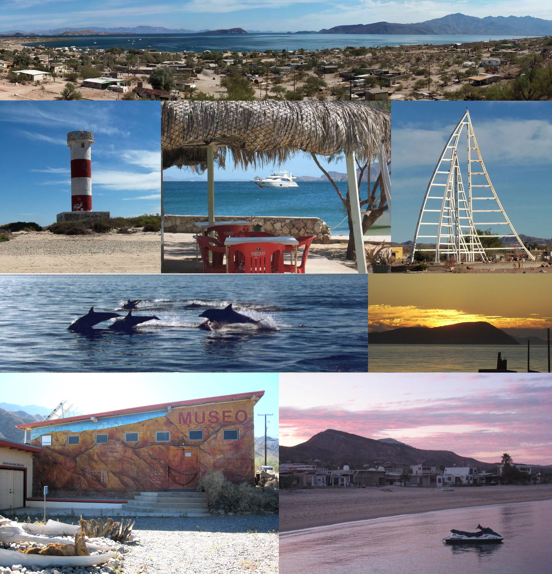
A multi-panel image collage showing various scenes from Bahia de los Angeles, including a town and bay view, a lighthouse, a coastal structure with a boat in the distance, a large sail-like monument, dolphins swimming, a sunset over the water, the local nature museum, and a beach at dusk with a jet ski.
A photographic montage highlighting the diverse landscapes, marine life, and local landmarks of the Bahia de los Angeles Biosphere Reserve.

Bahía de los Ángeles Biosphere Reserve wildlife and species highlights

The waters around Bahía de los Ángeles are internationally recognized for their megafauna. Each summer, between roughly 20 and 30 whale sharks visit the bay, offering one of the most accessible encounters with the species in the world. The reserve is also an important seasonal habitat for fin whales and other large cetaceans moving through the Sea of Cortez, and the Canal de las Ballenas is historically named for its concentrations of whales.

Sea lions are abundant, with colonies on Isla Calavera near Coronado (locally called Isla Smith) and on smaller rocks such as Isla El Racito in Ensenada El Alacrán. Five species of sea turtles use the area for feeding and nesting, including loggerheads, whose trans-Pacific migrations were first documented from research carried out right here. The bay's calm waters and rich plankton make it both a feeding ground and a seasonal nursery.

Sportfish populations are equally noteworthy. Yellowtail (jurel) is the most sought-after gamefish locally and can reach around 1.5 m and 60 kg; other targets include cabrilla, pargo, mero, sierra, bonita, and occasional dorado. Among the reserve's more unusual inhabitants are the endemic island reptiles, including the rattlesnakes Crotalus polisi on Isla Cabeza de Caballo and Crotalus thalassoporus on Isla Piojo, the spiny chuckwalla (Sauromalus hispidus) on Isla Ángel de la Guarda, the common side-blotched lizard (Uta stansburiana), and the speckled rattlesnake Crotalus mitchellii.

Bahía de los Ángeles Biosphere Reserve conservation status and protection priorities

Bahía de los Ángeles Biosphere Reserve was created to protect what is considered one of the most ecologically distinctive and productive marine-corridor ecosystems in the Gulf of California. The reserve covers a vast area of coastal desert, nearshore waters, and an archipelago that includes critical habitat for endangered marine species and endemic reptiles.

Sea turtle conservation has been a central pillar of the reserve's identity since the late 1970s. Long-term monitoring and head-starting programs at Campo Archelon, run over decades by biologist Antonio Reséndiz and partners, have contributed foundational knowledge about loggerhead migration and the broader ecology of the Gulf of California. These efforts continue today as part of the reserve's broader management framework.

The protection of island endemics, including rattlesnakes and chuckwallas that exist nowhere else, adds a distinct conservation dimension that goes beyond marine life. By linking desert, islands, and sea into a single protected unit, the reserve addresses interconnected threats such as overfishing, invasive species, unregulated tourism, and climate stress on coral and pelagic ecosystems, while supporting a gradual local shift away from commercial fishing toward sport fishing and nature-based tourism.

Bahía de los Ángeles Biosphere Reserve cultural meaning and human context

The cultural landscape of Bahía de los Ángeles is shaped by deep indigenous history, missionary exploration, frontier mining, and a modern fishing community. The bay has been part of Cochimí territory for thousands of years; the name Ádac, used by these original inhabitants of central Baja California, preserves that earlier identity.

Spanish exploration and missionary activity left lasting imprints, from the Jesuit landings of Juan de Ugarte and Ferdinand Konščak in the eighteenth century to the nearby Misión San Borja Ádac. Late nineteenth-century silver mining brought European-descended settlers whose descendants still populate the town, while the mid-twentieth-century writings of Fernando Jordán helped cement Bahía's image as a special place on the national Mexican imagination.

Closer to the reserve, the Gran Mural rock art region lies only about 30 km to the west, with prehistoric cave paintings in the Sierra de San Francisco estimated to be up to 10,000 years old. These constitute one of the most important archaeological sites in Baja California, anchoring the area's broader cultural significance beyond its ecological value.

Top sights and standout views in Bahía de los Ángeles Biosphere Reserve

A 1,500-square-mile protected coastal-marine complex combining desert, deep bays, and one of the most important island groups in the Sea of Cortez. Seasonal aggregations of whale sharks and rich sea turtle habitat support international research, including the first documented trans-Pacific migration of a loggerhead turtle.

Home to multiple endemic island reptiles, including rattlesnakes found only on Isla Cabeza de Caballo and Isla Piojo, and the spiny chuckwalla on Isla Ángel de la Guarda. A refuge where desert, islands, and ocean converge to form one of the most biologically distinctive seascapes in Mexico.

Best time to visit Bahía de los Ángeles Biosphere Reserve

The region has a hot arid climate, with very mild winters and intensely hot summers. Sea temperatures and wildlife activity follow strong seasonal patterns: the warm summer months bring the seasonal visits of whale sharks to the bay and active sea turtle nesting and feeding seasons, making this the most rewarding period for marine wildlife encounters.

Winter and spring bring milder air temperatures, calmer conditions for kayaking and exploration of the islands, and excellent visibility for coastal scenery. Because this is desert country, rainfall is minimal year-round, so travel plans are largely shaped by temperature tolerance and target species rather than by weather risk. Visitors aiming for whale sharks should focus on the warmest months, while those interested in hiking, scenery, and quieter conditions often prefer the cooler shoulder seasons.
Monthly climate preview

Long-term representative temperature and precipitation averages for Baja California

Bahía de los Ángeles Biosphere Reserve Climate Normals and Annual Weather Rhythm

Representative coordinates record measured monthly temperature and precipitation values across a multi-year baseline for Bahía de los Ángeles Biosphere Reserve. Detailed monthly climate normals provide broader analytical depth for evaluating long-term environmental patterns across the protected landscape.
Annual mean21 °C
14 °C29 °C
Jan14°
Feb15°
Mar17°
Apr19°
May21°
Jun25°
Jul29°
Aug29°
Sep28°
Oct23°
Nov18°
Dec14°
Warmest month
August

29.5 °C

Coolest month
January

14 °C

Wettest month
September

0.6 mm/day

Driest month
May

0 mm/day

Park location guide

Geography guide, regional context, and park location map for Bahía de los Ángeles Biosphere Reserve

Bahía de los Ángeles Biosphere Reserve park geography, regions, and map view in Mexico

Understand where Bahía de los Ángeles Biosphere Reserve sits in Mexico through a broader geographic reading of the surrounding landscape, nearby location context, and its mapped position within the national park landscape.

How Bahía de los Ángeles Biosphere Reserve fits into Mexico

Mexico, officially the United Mexican States, is a country in North America spanning the Sierra Madre mountain ranges, coastal plains, and tropical regions. It borders the United States to the north, Guatemala and Belize to the southeast, and has coastlines along the Pacific Ocean, Gulf of Mexico, and Caribbean Sea. With a population exceeding 130 million, Mexico is home to one of the world's most significant concentrations of Indigenous languages alongside Spanish.

Wider geography shaping Bahía de los Ángeles Biosphere Reserve in Mexico

Mexico occupies a land area of 1,972,550 km2, making it the thirteenth-largest country in the world. The terrain is highly diverse, featuring the Sierra Madre Occidental and Sierra Madre Oriental mountain ranges, the Mexican Plateau, coastal lowlands along the Pacific and Gulf/Caribbean margins, and the Yucatan Peninsula. The country spans multiple climate zones from desert in the north to tropical rainforest in the south.

Map view of Bahía de los Ángeles Biosphere Reserve

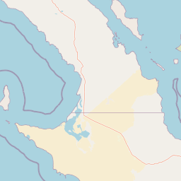
Use this park location map to pinpoint Bahía de los Ángeles Biosphere Reserve in Mexico, understand its exact geographic position, and read its mapped placement within the surrounding landscape more clearly.

Pigeon | © OpenStreetMap contributors

Location context for Bahía de los Ángeles Biosphere Reserve

Baja California

Visualizing the coastal desert terrain, offshore islands, and marine habitats of the Sea of Cortez

Bahía de los Ángeles Biosphere Reserve Photos and Landscapes

Photographic records capture the striking convergence of arid mountain ranges, sweeping bays, and rugged island chains across the protected marine reserve. Visual documentation reveals the distinct ecological character of sheltered coastal waters, volcanic landforms, and remote habitats found throughout the region.

A stylized map showing the coastline of Bahía de los Ángeles and several islands in the Gulf of California, with labels for various islands, geographic points, and an airfield.

A red and white striped cylindrical lighthouse stands on a sandy, scrub-covered coastal spit under a bright blue sky.

Panoramic landscape view of a coastal town nestled in a desert valley leading to a bay with distant islands under a bright sky.

A multi-panel image collage showing various scenes from Bahia de los Angeles, including a town and bay view, a lighthouse, a coastal structure with a boat in the distance, a large sail-like monument, dolphins swimming, a sunset over the water, the local nature museum, and a beach at dusk with a jet ski.

Park atlas

Compare adjacent marine reserves and regional desert landscapes across the Baja California coast

Parks Near Bahía de los Ángeles Biosphere Reserve and Surrounding Coastal Protected Areas

Compare coastal desert environments and marine reserves situated near Bahía de los Ángeles Biosphere Reserve to understand regional ecological connections. Broadening protected area analysis helps evaluate how arid mainland terrain and gulf ecosystems interact across the wider peninsula.
National parkBaja California
About 58 km away#1 closest

East

San Lorenzo Marine Archipelago National Park: Protected Area and Mapped Landscape Geography

Explore its national park status and regional context in Baja California.

Delve into San Lorenzo Marine Archipelago National Park, a key protected area contributing to Baja California's diverse geography. As a national park, its mapped boundaries and unique landscape characteristics provide essential data for atlas exploration and understanding regional conservation efforts. This entry focuses on the park's identity as a mapped protected entity, ideal for researchers and explorers seeking structured geographic insights into natural reserves.

Area
504.42 km²
Established
2005
IUCN
II
Relief
Upland
Nature reserveSonora
About 138 km away#2 closest

Southeast

Isla San Pedro Mártir Nature Reserve: Mapping the Geography of the Gulf of California

Isolated rocky terrain and productive marine sanctuary

Isla San Pedro Mártir serves as a distinct protected area marked by its extreme isolation and dramatic vertical cliffs. The reserve acts as a core seabird nesting site supported by nutrient-rich cold-water upwellings in the Gulf of California, providing a vital example of arid island and marine geography.

Area
2.729 km²
Scope
Mixed
Marine protected areaMexico
About 186 km away#3 closest

Southeast

Gulf of California: Marine Protected Area and Volcanic Geography of the Pacific Basin

Mapping protected islands and deep-sea terrain in Mexico

The Gulf of California represents a critical marine protected area defined by its tectonic youth and biological complexity. From the northern delta zones to the tropical southern waters, this basin offers a rare look at how submarine rifting and arid coastal geography influence marine habitat development. Explore its distribution of volcanic islands, deep canyons, and tidal environments through our detailed geographic records.

Area
177,000 km²
Established
2005
Relief
Mixed relief
Climate
Subtropical
Wildlife reserveBaja California
About 196 km away#4 closest

Northwest

Valle de los Cirios Wildlife Reserve: Mapped Geography and Protected Desert Landscapes

Exploring the diverse arid terrain of the Baja California peninsula

Valle de los Cirios represents a premier protected landscape in Mexico, characterized by its iconic cirio cactus woodlands and deep mountain sierras. The reserve connects vast stretches of desert habitat from the Pacific coast to the Gulf of California, creating a unique geographic corridor for endemic species and wide-ranging desert mammals.

Area
25,217.8 km²
Established
1980
Relief
Mountain
Climate
Arid
Protected areaBaja California Sur
About 230 km away#5 closest

South

San Ignacio Lagoon: Protected Coastal Desert Geography in Baja California Sur

Coastal lagoons, tidal channels, and desert ecosystems.

Examine the geographic boundaries and landscape features of San Ignacio Lagoon. This protected coastal nursery provides a rare desert-to-sea interface, characterized by shallow tidal flats, narrow channels, and expansive arid terrain within the Baja California Peninsula.

Area
175 km²
Established
2004
Relief
Lowland
Climate
Arid
Watercolor painting of a mountainous landscape with pine trees, rolling hills, and a pastel sky
National parkBaja California
About 286 km away#6 closest

Northwest

Sierra de San Pedro Mártir National Park: Protected Landscape and Geographic Exploration

National park boundaries and natural terrain in Baja California.

Sierra de San Pedro Mártir National Park is a vital protected landscape situated in Baja California. This destination offers users a focused atlas exploration of its national park status, detailing its geographic setting and mapped protected area. Understand the park's specific place within the region, examining its natural terrain and boundaries for a clear geographic context, essential for any structured discovery of Mexico's conserved lands.

Area
729.09 km²
Established
1947
IUCN
II
Relief
Mountain
Wildlife reserveSonora
About 406 km away#7 closest

Northeast

Bavispe Flora and Fauna Protection Area: Sierra Madre Occidental Mountain Geography

Mapped protected forest tracts across Sonora ranges

Spanning five distinct mountain tracts in Sonora, this wildlife reserve preserves rare pine-oak forest communities within the Sierra Madre Occidental. Learn how these ridges and basins act as a vital hydrological anchor for the Yaqui River and provide critical corridors for wildlife through the diverse, transition-heavy terrain of northern Mexico.

Area
2,009 km²
Established
1936
IUCN
VI
Relief
Mountain
National parkEnsenada Municipality
About 417 km away#8 closest

Northwest

Constitution 1857 National Park National Park: Mapped Protected Landscape Discovery

Geographic context and park boundaries for Ensenada Municipality.

Delve into the protected landscape of Constitution 1857 National Park, a key national park entity located in the Ensenada Municipality. This resource highlights the park's distinct geographic features and mapped protected area, crucial for atlas exploration and understanding the regional natural terrain. Gain structured insight into the park's identity and its role within the wider geographic context.

Area
50.09 km²
Established
1962
IUCN
II
Relief
Mountain

Common questions about visiting, size, designation, and location context for Bahía de los Ángeles Biosphere Reserve

Bahía de los Ángeles Biosphere Reserve FAQs for park facts, access, geography, and protected area context

Find quick answers about Bahía de los Ángeles Biosphere Reserve, including protected-area facts, park geography, trail and visitor context, and how the park fits into its surrounding country and regional landscape.
MoriAtlas Explorer

Continue Your Protected Areas Search Across the Global Atlas

Deepen your exploration by continuing the structured search for national parks and protected areas worldwide. Utilize the comprehensive filtering capabilities to compare different conservation landscapes and refine your understanding of global park geography. Discover more about the distribution and characteristics of protected natural areas.

Global natural geography