

Mori Atlas logo
Wildlife reserveRefuge d'oiseaux migrateurs de la Baie-Boatswain

Mapping the subarctic estuarine habitats and migratory flyway corridors of James Bay

Refuge d'oiseaux migrateurs de la Baie-Boatswain: A Vital Coastal Protected Wildlife Reserve

Refuge d'oiseaux migrateurs de la Baie-Boatswain serves as a critical protected sanctuary along the southeastern shores of James Bay, Quebec. This remote reserve encompasses a complex network of tidal flats, shallow brackish waters, and offshore islands that provide essential staging grounds for Arctic-nesting waterfowl. By safeguarding these intertidal and nearshore environments, the reserve maintains the ecological integrity of a major North American migratory flyway corridor.

migratory bird sanctuarywaterfowl habitatgeeseJames Bay coastsubarctic coastal ecosystemtidal flats

Refuge d'oiseaux migrateurs de la Baie-Boatswain

Wildlife reserve

Park overview

Structured park overview, official facts, and landscape profile for Baie-Boatswain Migratory Bird Sanctuary

Baie-Boatswain Migratory Bird Sanctuary park facts, protected area profile, and essential visitor context

Review the core facts for Baie-Boatswain Migratory Bird Sanctuary, including designation, size, terrain, visitor scale, habitats, and operating context in one park-focused overview.

About Baie-Boatswain Migratory Bird Sanctuary

Baie-Boatswain Migratory Bird Sanctuary is a federally protected area in northern Canada whose purpose is to safeguard essential migratory habitat along Boatswain Bay, near the southeastern coast of James Bay. The sanctuary forms part of Canada's long-established network of migratory bird reserves, which together protect breeding, staging, and wintering sites used by waterfowl along major flyway corridors.

Although geographically small by national-park standards, the sanctuary plays a disproportionately important ecological role because it protects a key segment of one of North America's most significant migratory waterfowl corridors. The coast of James Bay and Hudson Bay is widely recognized as a globally important staging area for geese, swans, and shorebirds moving between temperate wintering areas and Arctic breeding grounds, and Baie-Boatswain contributes to safeguarding this connection.

The protected area combines nearshore marine waters with islands, tidal flats, and shoreline habitats. Such combinations of freshwater influence from inland rivers, estuarine mixing zones, and Arctic-marine conditions create highly productive feeding areas, especially during spring and fall when migratory birds need to accumulate energy reserves. By limiting human disturbance, the sanctuary helps ensure these habitats remain available year after year for migrating populations.

In practical terms, the sanctuary represents one of the older foundations of Canada's migratory bird conservation framework. Its remote location, minimal infrastructure, and tight ecological focus reflect the original purpose of the migratory bird sanctuary system: to set aside undisturbed landscapes where waterfowl can complete their life cycle free from significant human pressure.

Quick facts and research context for Baie-Boatswain Migratory Bird Sanctuary

The Baie-Boatswain Migratory Bird Sanctuary is administered by the Canadian Wildlife Service as part of Canada's national system of migratory bird sanctuaries. Designated on January 29, 1941, it is among the longest-established federal bird sanctuaries in the country.

The protected area straddles the boundary between Quebec and Nunavut and lies along Boatswain Bay, southeast of James Bay. Its total area is modest, with a portion designated as marine habitat. The sanctuary focuses on coastal waters, nearshore islands, tidal flats, and adjacent rocky features used by geese and other migratory birds.

Protection and recognition

Examine the verified conservation status, administrative framework, and international database records for this protected landscape.

Refuge d'oiseaux migrateurs de la Baie-Boatswain Protection Status and Protected Area Documentation

Explore the documented protection status, management scope, and official designation records associated with Refuge d'oiseaux migrateurs de la Baie-Boatswain. Review the structured conservation metrics and verifiable database identifiers that define this protected natural area within the global atlas.

Protection details

WDPA ID
4160
Park context

Deeper park guide and search-rich context for Baie-Boatswain Migratory Bird Sanctuary

Baie-Boatswain Migratory Bird Sanctuary history, landscape, wildlife, and travel context

Explore Baie-Boatswain Migratory Bird Sanctuary through its history, landscape character, ecosystems, wildlife, conservation priorities, cultural context, and seasonal travel timing in a structured park guide built for atlas discovery and search intent.

Why Baie-Boatswain Migratory Bird Sanctuary stands out

The sanctuary is best known for protecting a vital migratory stopover used by several species of Arctic-breeding geese, including Canada goose, greater snow goose, and brant, which rely on the bay's coastal habitats during seasonal migration. The area's combination of shallow estuarine waters, sheltered bays, tidal flats, offshore islands, and exposed reef features makes it a preferred concentration site where birds can rest, feed, and stage before continuing their journey between southern wintering grounds and the High Arctic.

Baie-Boatswain Migratory Bird Sanctuary history and protected-area timeline

The Baie-Boatswain Migratory Bird Sanctuary was established on January 29, 1941, under Canada's migratory bird protection framework. Its creation predates many contemporary Canadian conservation programs and reflects a period when the federal government was actively assembling a national network of protected sites along major migratory corridors.

The sanctuary's early designation was driven by the recognition that the coast of James Bay served as a major concentration area for geese moving between southern wintering regions and High Arctic breeding colonies. By protecting Boatswain Bay and its associated islands and nearshore waters, the government sought to preserve a critical segment of the migratory flyway at minimal cost and without the need for active land management, in keeping with the sanctuary model of that era.

Ongoing administration has remained with the Canadian Wildlife Service, which oversees the sanctuary as part of the broader migratory bird sanctuary program. Over time, the site's importance has been reinforced by growing awareness of the ecological significance of James Bay and Hudson Bay lowlands for migratory waterfowl, placing Baie-Boatswain within a broader regional conservation context.

Baie-Boatswain Migratory Bird Sanctuary landscape and geographic character

The landscape of the Baie-Boatswain sanctuary is defined by the coastal setting of Boatswain Bay, a small embayment along the southeastern shore of James Bay. The terrain features low, flat coastal profiles typical of the James Bay lowland, where vast wetland systems meet the sea and create gradual transitions between land and water.

Within the sanctuary, the most characteristic physical features are the nearshore islands, rocky reefs, and tidal flats scattered across the bay. These intertidal and subtidal zones form platforms where seabirds and waterfowl can rest, feed, and gather during migration. The shallow, sheltered nature of the bay, combined with freshwater influxes from inland rivers and the brackish influence of James Bay, creates nutrient-rich feeding conditions.

The surrounding hinterland consists of low tundra and boreal-forest transition vegetation, consistent with the subarctic character of the James Bay coast. The visual experience of the landscape is one of expansive open skies, distant horizons, broad tidal flats, and small rocky islands punctuating calm coastal waters.

Baie-Boatswain Migratory Bird Sanctuary ecosystems, habitats, and plant life

The ecological character of Baie-Boatswain centers on the interface between coastal wetlands and estuarine waters along James Bay. The bay's sheltered shallow areas are biologically productive, supporting aquatic vegetation, invertebrates, and small fish populations that in turn sustain large numbers of migratory waterfowl.

The mosaic of tidal flats, nearshore islands, and rocky reef structures provides diverse habitat types within a relatively small geographic area. Tidal mudflats and shallow embayments support rich invertebrate communities that are essential for fueling migrating geese; offshore reef structures and island roosts offer secure resting areas relatively safe from terrestrial predators; and surrounding wetland margins contribute to broader coastal ecological connectivity along James Bay.

The sanctuary's vegetation patterns reflect the subarctic coastal environment, with low-growing tundra communities, saltmarsh patches, and transitional boreal elements near the inland edge. These ecosystems are ecologically sensitive and depend heavily on the absence of major disturbance to maintain their function as migratory bird habitat.

Baie-Boatswain Migratory Bird Sanctuary wildlife and species highlights

The primary wildlife significance of the Baie-Boatswain sanctuary lies in its role as a migratory stopover for geese. The sanctuary was specifically designated to protect a key staging area for Canada goose, greater snow goose, and brant, all of which use the bay during their seasonal movements.

Beyond these flagship species, the habitats protected within the sanctuary support a wider community of migratory and resident birds, including waterfowl, shorebirds, and seabirds that rely on the same coastal mosaic of islands, tidal flats, and shallow marine waters. The bay's concentration of prey resources makes it an attractive feeding and resting site during high-energy periods of migration.

While the sanctuary's wildlife focus is on birds, the broader estuarine environment also supports typical subarctic coastal fauna, including fish, marine invertebrates, and occasional marine mammals associated with James Bay. The protected zone contributes to maintaining a relatively undisturbed natural baseline in a region undergoing increasing pressure from climate change and potential development in the James Bay lowlands.

Baie-Boatswain Migratory Bird Sanctuary conservation status and protection priorities

Baie-Boatswain holds conservation significance both as a stand-alone protected site and as a component of the larger network of migratory bird sanctuaries along the James Bay and Hudson Bay coast. The sanctuary contributes to safeguarding a federally recognized migratory corridor that supports multiple Arctic-breeding waterfowl species, aligning with international flyway conservation priorities.

The sanctuary is classified in international databases as a strict nature reserve under the IUCN system, reflecting its emphasis on minimizing human intervention and maintaining natural ecological processes. Its long-standing designation, dating to 1941, gives it historical weight within the Canadian conservation framework and reinforces its role as a baseline reference site for monitoring migratory waterfowl populations along this coast.

Because the James Bay region faces growing environmental pressures, including hydroelectric development interest, shipping, and climate-driven ecological change, the continued protected status of Baie-Boatswain adds a degree of resilience to migratory bird populations that depend on relatively undisturbed coastal stopover sites. The sanctuary is administered by the Canadian Wildlife Service as part of this strategic conservation approach.

Baie-Boatswain Migratory Bird Sanctuary cultural meaning and human context

The sanctuary lies along the southeastern coast of James Bay in a region historically associated with Indigenous Cree communities whose presence along the bay predates federal conservation designations. The coastal wetlands, islands, and estuarine resources of James Bay have long been part of traditional land use, including seasonal hunting of waterfowl and other bird species during migration.

While the sanctuary itself is administered strictly for migratory bird conservation through the federal system, its setting reflects a landscape with deep cultural and subsistence ties to Indigenous communities in the broader James Bay region. This cultural layer provides important context for understanding how the area has historically interacted with human populations, even under its current protective designation.

Top sights and standout views in Baie-Boatswain Migratory Bird Sanctuary

The standout qualities of Baie-Boatswain include its position on one of North America's most important waterfowl migration corridors, its long-standing protected status as a 1941 federal designation, and its tightly focused ecological mission around migratory geese and coastal staging habitat.

The combination of nearshore islands, tidal flats, and shallow estuarine waters within a single sanctuary creates a compact but high-value refuge for migratory birds. The sanctuary's isolation and minimal infrastructure underscore its character as a remote, undisturbed coastal protection site rather than a publicly developed visitor destination.

Best time to visit Baie-Boatswain Migratory Bird Sanctuary

The sanctuary's ecological seasonality centers on the spring and fall migration periods, when Arctic-breeding geese move through Boatswain Bay in significant numbers. Spring generally brings northward-bound flocks staging on the bay's tidal flats and nearshore waters, while fall draws southward-moving birds preparing for the winter ahead.

Because the site is remote, subject to harsh subarctic weather, and managed primarily for migratory bird protection rather than visitor access, on-the-ground visitation is extremely limited. The most relevant sense of "when to visit" applies to understanding when the sanctuary is most ecologically active, namely the spring and autumn windows when migrating geese dominate the bay's bird life. Summer brings milder conditions but reduced migratory concentrations, and winter conditions severely restrict human movement in the region.

Monthly climate preview

Examine the long-term temperature range and monthly precipitation rhythm across the sanctuary landscape

Refuge d'oiseaux migrateurs de la Baie-Boatswain Climate Normals and Weather by Month

Temperature and precipitation data for Refuge d'oiseaux migrateurs de la Baie-Boatswain reveal measured monthly fluctuations spanning deep sub-zero winters to mild summer peaks. Reviewing the complete twelve-month climate profile provides detailed context on long-term weather averages and seasonal variations.
Annual mean-1 °C
-18 °C12 °C
Jan-18°
Feb-17°
Mar-11°
Apr-4°
May
Jun
Jul12°
Aug12°
Sep
Oct
Nov-3°
Dec-12°
Warmest month
August

12.1 °C

Coolest month
January

-18.1 °C

Wettest month
September

3.6 mm/day

Driest month
February

1 mm/day

Park location guide

Geography guide, regional context, and park location map for Baie-Boatswain Migratory Bird Sanctuary

Baie-Boatswain Migratory Bird Sanctuary park geography, regions, and map view in Canada

Understand where Baie-Boatswain Migratory Bird Sanctuary sits in Canada through a broader geographic reading of the surrounding landscape, nearby location context, and its mapped position within the national park landscape.

How Baie-Boatswain Migratory Bird Sanctuary fits into Canada

Canada is a federal parliamentary constitutional monarchy spanning North America from the Atlantic to the Pacific and Arctic Oceans. With a population of over 41 million, it is officially bilingual in English and French at the federal level. The country gained independence from the United Kingdom through a gradual process culminating in 1982.

Wider geography shaping Baie-Boatswain Migratory Bird Sanctuary in Canada

Canada occupies the northern portion of North America, sharing its longest international border with the United States. The country extends from the Atlantic Ocean to the Pacific Ocean and northward into the Arctic Ocean, giving it the longest coastline of any nation.

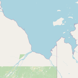
Map view of Baie-Boatswain Migratory Bird Sanctuary

Use this park location map to pinpoint Baie-Boatswain Migratory Bird Sanctuary in Canada, understand its exact geographic position, and read its mapped placement within the surrounding landscape more clearly.

Pigeon | © OpenStreetMap contributors

Location context for Baie-Boatswain Migratory Bird Sanctuary

NunavutQuebec
Park atlas

Compare adjacent coastal ecosystems and surrounding northern wetland reserves.

Parks Near Refuge d'oiseaux migrateurs de la Baie-Boatswain and Related Protected Landscapes

Browsing nearby protected areas helps connect the estuarine habitats of Refuge d'oiseaux migrateurs de la Baie-Boatswain with broader regional conservation networks across the James Bay coast. Comparing adjacent northern reserves provides valuable context on subarctic flyways, coastal wetlands, and regional waterfowl habitats.
Wildlife reserveOntario
56 km away#1 closest

Southwest

Refuge d'oiseaux migrateurs de la Baie-Hannah: Ontario Coastal Wildlife Reserve Atlas

Mapped wetlands and protected habitat on James Bay

Focusing on the broad, low-lying coastal zone of southern James Bay, Refuge d'oiseaux migrateurs de la Baie-Hannah serves as a primary site for understanding subarctic marsh ecosystems. The sanctuary protects a mosaic of salt-tolerant vegetation and tidal mudflats, preserving a remote and productive landscape of regional conservation importance within the Ontario territory.

Area
252.18 km²
Established
1939
IUCN
Ib
Relief
Lowland
National parkThunder Bay District
600 km away#2 closest

Southwest

Pukaskwa National Park National Park: Explore Its Protected Landscape and Geographic Identity

Discover the mapped boundaries and regional atlas context.

Pukaskwa National Park represents a key protected area, offering critical insights into the regional geography of Thunder Bay District. As a national park, its mapped boundaries and unique landscape identity are central to understanding Canada's protected lands. This entry provides the foundational geographic context for exploring Pukaskwa National Park within a structured atlas framework, detailing its place among other natural landscapes.

Area
1,878 km²
Established
1978
IUCN
II
Visitors
17.3K annual
National parkQuebec
686 km away#3 closest

Southeast

La Mauricie National Park: Quebec National Park Atlas and Protected Landscape

Explore its mapped boundaries and natural terrain.

Delve into the protected landscape of La Mauricie National Park, a key national park situated within Quebec's diverse geography. This destination provides detailed insights into the park's mapped boundaries and its unique natural terrain, offering a structured approach to understanding protected areas and regional landscapes. It serves as an essential point for exploring the park's geographic identity and its place within the Canadian conservation atlas.

Area
536 km²
Established
1970
IUCN
II
Visitors
278.9K annual
A watercolor painting of a rolling, soft-toned landscape with a foreground of green forest and layers of hills receding into the distance.
Protected landscapeUpper Peninsula of Michigan
718 km away#4 closest

Southwest

Hiawatha National Forest: Geographic Overview and Protected Area Map of the Upper Peninsula

Coastal forest landscape and wilderness river corridors.

Hiawatha National Forest spans significant portions of the Upper Peninsula of Michigan, bridging the gap between northern hardwood forests and the boreal environments of the Great Lakes. This protected landscape encompasses extensive shorelines along Lake Superior, Lake Michigan, and Lake Huron, alongside six wilderness areas and five designated wild and scenic rivers.

Area
3,621.27 km²
Established
1931
IUCN
VI
Relief
Lowland
Marine protected areaMichigan
742 km away#5 closest

Southwest

Thunder Bay National Marine Sanctuary: Geography and Protected Maritime Landscape Context

Mapping underwater heritage in the Michigan Great Lakes region

Spanning 4,300 square miles of Lake Huron, Thunder Bay National Marine Sanctuary preserves a significant collection of shipwrecks within a glacially shaped freshwater terrain. This marine protected area offers a look at submerged geography ranging from shallow coastal bays to deep lake basins. It serves as a vital anchor for understanding maritime history and freshwater ecosystem stability across the Michigan shoreline.

Area
11,000 km²
Established
2000
Relief
Lowland
Climate
Temperate
National parkOntario
745 km away#6 closest

South

Georgian Bay Islands National Park: Ontario National Park Protected Landscape Atlas

Explore mapped boundaries and regional geographic context.

Gain a comprehensive understanding of Georgian Bay Islands National Park as a distinct protected area within Ontario. This entry provides detailed geographic context, focusing on the park's mapped landscape, its protected status as a national park, and its position within the regional geography of Canada. It is designed for users seeking structured information about protected lands and their atlas-level significance.

Area
13.5 km²
Established
1929
IUCN
II
Visitors
27.5K annual
National parkOntario
746 km away#7 closest

South

Bruce Peninsula National Park: National Park Protected Landscape and Geographic Context in Ontario

Discover its mapped boundaries and regional landscape identity.

Bruce Peninsula National Park stands as a protected national park entity within Ontario, offering a distinct geographic profile. Its mapped boundaries and position within the regional atlas are crucial for understanding its landscape character. MoriAtlas facilitates exploration of the park's protected status and its contribution to the conservation landscape of Ontario.

Area
154 km²
Established
1987
IUCN
II
Visitors
460.4K annual
Wildlife reserveOntario
About 754 km away#8 closest

South

Eleanor Island Wildlife Reserve: Protected Ontario Lake Landscape and Bird Habitat

A federal migratory bird sanctuary in the Canadian Shield

Eleanor Island is a strictly protected migratory bird sanctuary in Ontario that serves as a vital nesting ground for colonial waterbirds. Positioned within Lake Muskoka, this small but ecologically purposeful nature reserve demonstrates the importance of localized federal protection for regional breeding populations. Its status as a strict nature reserve underscores a commitment to safeguarding sensitive habitats within the broader Canadian Shield wilderness.

Area
0.006 km²
Established
1978
IUCN
Ia
Relief
Lowland

Common questions about visiting, size, designation, and location context for Baie-Boatswain Migratory Bird Sanctuary

Baie-Boatswain Migratory Bird Sanctuary FAQs for park facts, access, geography, and protected area context

Find quick answers about Baie-Boatswain Migratory Bird Sanctuary, including protected-area facts, park geography, trail and visitor context, and how the park fits into its surrounding country and regional landscape.
MoriAtlas Explorer

Continue Your Protected Areas Search Across the Global Atlas

Deepen your exploration by continuing the structured search for national parks and protected areas worldwide. Utilize the comprehensive filtering capabilities to compare different conservation landscapes and refine your understanding of global park geography. Discover more about the distribution and characteristics of protected natural areas.

Global natural geography
