

Mori Atlas logo
National parkBantimurung-Bulusaraung National Park

Discover the atlas context and regional geographic identity of this Indonesian national park.

Bantimurung-Bulusaraung National Park: Protected Landscape Geography and Mapped Boundaries in South Sulawesi

(Taman Nasional Bantimurung-Bulusaraung)

Bantimurung-Bulusaraung National Park represents a significant protected area within South Sulawesi, Indonesia. This page details its geographical features and mapped boundaries, offering an essential point of discovery for understanding its place in the natural landscape atlas. Explore the park's inherent protected land character and regional context, providing a foundation for broader geographic exploration.

Karst LandscapeCave SystemsEndemic WildlifeBirdwatchingButterfly DiversityTropical Forest

Bantimurung-Bulusaraung National Park

National park

Park overview

Structured park overview, official facts, and landscape profile for Bantimurung-Bulusaraung National Park

Bantimurung-Bulusaraung National Park park facts, protected area profile, and essential visitor context
Review the core facts for Bantimurung-Bulusaraung National Park, including designation, size, terrain, visitor scale, habitats, and operating context in one park-focused overview.

About Bantimurung-Bulusaraung National Park

Bantimurung-Bulusaraung National Park represents one of Indonesia's most distinctive protected areas, combining extraordinary geological significance with remarkable biological diversity. The park's defining feature is its vast karst landscape, a limestone terrain sculpted over millions of years into dramatic towers, cliffs, and cave systems that rank among the world's most impressive. The karst formation extends across Maros and Pangkep regencies, creating a landscape of towering limestone pillars that rise almost vertically from the surrounding terrain, forming what appears to be a natural cathedral of stone. This geological wonder has drawn scientific attention for decades, culminating in a 1993 recommendation from the International Union of Speleology for World Heritage status. Beyond its geological significance, the park occupies a critical position in the Asia-Australia transition zone, creating unique ecological conditions that support species found nowhere else on the planet. The park's accessibility from Makassar, just an hour's drive or 30 minutes from the international airport, makes it a practical destination for visitors seeking to experience one of Indonesia's most remarkable natural landscapes. The combination of accessible natural wonders, significant biodiversity, and geological importance makes this park a cornerstone of Sulawesi's conservation portfolio.

Quick facts and research context for Bantimurung-Bulusaraung National Park

Bantimurung-Bulusaraung National Park spans 437 square kilometers in South Sulawesi, Indonesia, protecting one of the world's most significant karst landscapes. The park was formally established in 2004 following decades of conservation advocacy, including recommendations from the 1993 International Union of Speleology Congress. The Rammang-Rammang karst area forms the park's centerpiece, comprising approximately 43,750 hectares of limestone formations with 286 cataloged caves. The park lies just 20 kilometers from Sultan Hasanuddin International Airport in Makassar, making it highly accessible. Alfred Wallace first explored the area in 1857, documenting remarkable biodiversity that continues to attract researchers and nature enthusiasts.

Park context

Deeper park guide and search-rich context for Bantimurung-Bulusaraung National Park

Bantimurung-Bulusaraung National Park history, landscape, wildlife, and travel context
Explore Bantimurung-Bulusaraung National Park through its history, landscape character, ecosystems, wildlife, conservation priorities, cultural context, and seasonal travel timing in a structured park guide built for atlas discovery and search intent.

Why Bantimurung-Bulusaraung National Park stands out

Bantimurung-Bulusaraung is most renowned for its world-class karst landscape, featuring the second-largest karst system globally and an extraordinary network of 286 caves. The park is famously called the "butterfly kingdom" by Alfred Wallace, who documented 256 butterfly species during his 1857 expedition. The area hosts remarkable endemic wildlife including the Sulawesi moor macaque, red-knobbed hornbill, and the rare Tarsius fuscus. The Bantimurung waterfall with its adjacent caves serves as the park's most accessible landmark, while the Rammang-Rammang karst region offers spectacular towering limestone pillars and underground cave systems.

Bantimurung-Bulusaraung National Park history and protected-area timeline

The history of Bantimurung-Bulusaraung National Park reflects decades of evolving conservation recognition. Alfred Wallace first conducted systematic exploration of the Bantimurung area between July and October 1857, documenting the region's extraordinary biodiversity in his seminal work "The Malay Archipelago." His observations, particularly regarding the area's remarkable butterfly populations, established the site's scientific prominence and attracted subsequent researchers. Between 1970 and 1980, Indonesian authorities established five conservation areas within the Maros-Pangkep karst region, comprising two nature parks and three wildlife sanctuaries. The 1993 International Union of Speleology Congress held in Italy recommended the Maros-Pangkep Karst as a World Heritage site, highlighting its global significance. Following this, Hasanuddin University's Environmental Seminar in 1998 further advocated for formal protection. In May 2001, the IUCN Asia Regional Office and UNESCO World Heritage Center convened the Asia-Pacific Forum on Karst Ecosystems and World Heritage in Sarawak, Malaysia, reinforcing international pressure for conservation. Finally, in 2004, the Indonesian Ministry of Forestry formally declared the allocation of 43,750 hectares as Bantimurung-Bulusaraung National Park, integrating wildlife conservatory, nature park, and various forest designations under unified management.

Bantimurung-Bulusaraung National Park landscape and geographic character

The landscape of Bantimurung-Bulusaraung National Park is dominated by one of the world's most spectacular karst formations. The limestone terrain stretches across approximately 43,750 hectares, characterized by towering limestone pillars, steep cliffs, and an intricate network of caves. The karst formations rise at nearly 90-degree angles along roads traversing from Maros city through Bantimurung and continuing to Pangkajene and Islands Regency. The Rammang-Rammang area contains the park's most dramatic scenery, with limestone peaks rising abruptly from the landscape. Within the karst system, 286 caves have been documented, including 33 prehistoric caves with significant archaeological potential. The park also features the Bantimurung waterfall, where water cascades into a pool flanked by two caves, one known as the "dream cave" extending approximately one kilometer in length and another called the "stone cave." The green river that flows through the park adds another dimension to the landscape, its waters winding through the karst terrain.

Bantimurung-Bulusaraung National Park ecosystems, habitats, and plant life

The nature of Bantimurung-Bulusaraung reflects its position at the biogeographic crossroads between Asian and Australian zones, creating unique ecological conditions. The park's diverse habitats range from karst forest on limestone outcrops to lowland tropical vegetation and cave ecosystems. The karst forests represent particularly important habitats, hosting specialized plant species adapted to the nutrient-poor limestone substrate. Cave systems support distinct ecological communities adapted to dark, humid conditions, including unique invertebrate assemblages. The park's elevation gradient and varied topography create multiple microhabitats that support diverse species. The karst aquifer systems beneath the surface store significant groundwater resources, feeding springs and maintaining ecosystem function across the dry season. These ecological characteristics make the park a living laboratory for understanding tropical karst ecosystem dynamics.

Bantimurung-Bulusaraung National Park wildlife and species highlights

Bantimurung-Bulusaraung hosts an impressive array of endemic wildlife, particularly due to its position in the Asia-Australia transition zone. The park is home to the Sulawesi moor macaque, a distinctive primate species found only on Sulawesi. The red-knobbed hornbill and Sulawesi hornbill represent the park's avian treasures, these large fruit-eating birds playing important roles in seed dispersal. The Sulawesi palm civet, one of the island's endemic carnivores, prowls the forest canopy. The park also supports populations of cuscus, the unique marsupial of Sulawesi, as well as various bat species and pot-bellied boar. The cave systems harbor unique species including the spider crab, a critically endangered crustacean known only from Maros karst caves. Most remarkably, park staff documented the presence of Tarsius fuscus in 2008, adding to the park's conservation significance. The butterfly diversity remains extraordinary, with Wallace documenting 256 species in 1857 and subsequent surveys identifying at least 103 species within the park itself, including endemic species such as Papilio blumei and Graphium androcles.

Bantimurung-Bulusaraung National Park conservation status and protection priorities

Bantimurung-Bulusaraung represents a crucial conservation priority both nationally and globally. The karst landscape's designation as the second-largest in the world underscores its international significance, and the 1993 recommendation from the International Union of Speleology for World Heritage status reflects its global importance. The park protects endemic species found nowhere else, including the spider crab that exists only in Maros karst caves. However, the park faces significant conservation challenges, particularly from tourism pressure. Approximately 600,000 visitors annually, predominantly domestic tourists, have created resource management challenges. Historically, butterfly collection for commercial purposes represented a significant threat, though management has shifted toward preservation-focused approaches. The Indonesian government identified butterflies as a priority group in the National Species Conservation Strategic Directions 2008-2018. Conservation efforts now focus on protecting the karst ecosystem, preserving cave systems, and maintaining the unique biodiversity that makes this park globally significant.

Bantimurung-Bulusaraung National Park cultural meaning and human context

Bantimurung-Bulusaraung holds deep cultural significance for the local communities of South Sulawesi. The area has been inhabited for millennia, as evidenced by the 33 prehistoric caves containing archaeological materials. The landscape features in local traditions and storytelling, with the karst formations holding spiritual significance for regional communities. Local communities have historically interacted with the park's resources, particularly through traditional butterfly harvesting that has been practiced since the 1970s. The park management involves local residents in butterfly breeding programs and conservation activities, creating a model for integrated conservation. The area's proximity to Makassar and its status as a popular destination for domestic tourism further embeds it in the cultural landscape of South Sulawesi, where it serves as both a natural wonder and a source of local pride and economic activity.

Top sights and standout views in Bantimurung-Bulusaraung National Park

Bantimurung-Bulusaraung National Park offers exceptional highlights that distinguish it among Indonesia's protected areas. The Rammang-Rammang karst landscape provides world-class scenery with its towering limestone pillars and vast cave systems. The Bantimurung waterfall with its dual caves offers accessible natural beauty. The extraordinary butterfly diversity, recognized by Wallace as a "butterfly kingdom," remains a signature attraction. The park provides critical habitat for endemic species including the Sulawesi moor macaque, red-knobbed hornbill, and unique cave-dwelling species. The 286 documented caves, including significant prehistoric sites, offer extraordinary opportunities for speleological exploration. The park's position at the Asia-Australia biogeographic transition creates unique ecological conditions found nowhere else on Earth.

Best time to visit Bantimurung-Bulusaraung National Park

The optimal time to visit Bantimurung-Bulusaraung National Park corresponds with the dry season in South Sulawesi, typically from April to October. During these months, weather conditions allow for comfortable exploration of outdoor attractions including the karst landscapes, caves, and waterfall. The dry season provides easier access to cave systems and reduces hazards associated with slippery trails. However, visitors should note that the park's popularity means crowding during peak holiday periods, particularly Indonesian holidays. The wet season, from November to March, brings heavier rainfall that can affect trail conditions and cave access but also offers a different landscape character with lusher vegetation. Year-round visits are possible, but planning around the dry season generally provides the most favorable conditions for experiencing the park's diverse attractions.
Park location guide

Geography guide, regional context, and park location map for Bantimurung-Bulusaraung National Park

Bantimurung-Bulusaraung National Park park geography, regions, and map view in Indonesia
Understand where Bantimurung-Bulusaraung National Park sits in Indonesia through a broader geographic reading of the surrounding landscape, nearby location context, and its mapped position within the national park landscape.

How Bantimurung-Bulusaraung National Park fits into Indonesia

Indonesia is a vast archipelagic nation in Southeast Asia and Oceania, spanning over 17,000 islands between the Indian and Pacific Oceans. As the world's fourth-most populous country with 288 million people, it features extraordinary cultural and biological diversity, withJavanese and Sundanese being the largest ethnic groups. The country gained independence from the Netherlands in 1945 and operates as a unitary presidential republic.

Wider geography shaping Bantimurung-Bulusaraung National Park in Indonesia

Indonesia is situated in Southeast Asia and Oceania, spanning the equatorial region between the Indian Ocean to the west and the Pacific Ocean to the east. The archipelago includes major islands such as Sumatra, Java, Sulawesi, and parts of Borneo and New Guinea. It borders Papua New Guinea, Timor-Leste, and Malaysia by land, with extensive maritime boundaries throughout the region.

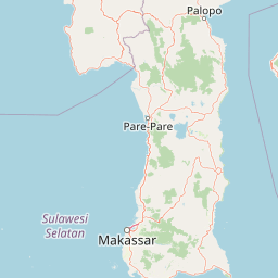
Map view of Bantimurung-Bulusaraung National Park

Use this park location map to pinpoint Bantimurung-Bulusaraung National Park in Indonesia, understand its exact geographic position, and read its mapped placement within the surrounding landscape more clearly.

Pigeon | © OpenStreetMap contributors

Location context for Bantimurung-Bulusaraung National Park

South Sulawesi
Park atlas

Trace the regional spread of conservation efforts and compare diverse protected landscapes in South Sulawesi, Indonesia.

Discover Nearby Protected Areas and Karst Landscapes Beyond Bantimurung-Bulusaraung National Park
Continue your exploration from Bantimurung-Bulusaraung National Park to find other national parks and protected areas across Indonesia's diverse regional geography, including similar karst systems and unique ecological zones. Compare adjacent conservation landscapes and map the geographic distribution of protected sites to deepen your understanding of the region's natural heritage and conservation efforts.
National parkWest Sulawesi

Gandang Dewata National Park: Protected Area Identity and Geographic Context in West Sulawesi

Explore mapped boundaries and regional landscape.

Delve into the protected landscape of Gandang Dewata National Park, a key national park situated in West Sulawesi. This resource offers a detailed geographic perspective, emphasizing its mapped boundaries and its position within the regional atlas. Understand the park's protected-area status and its contribution to the natural geography of Indonesia, serving as a vital point for atlas exploration.

Area
793.42 km²
Established
2016
IUCN
II
Relief
Mountain
National parkSouth East Sulawesi

Rawa Aopa Watumohai National Park: Geographic Atlas and Protected Landscape Overview

Explore Rawa Aopa Watumohai National Park's mapped boundaries.

Gain a clear understanding of Rawa Aopa Watumohai National Park, a designated national park in South East Sulawesi. This entry offers insight into its protected landscape identity, mapped geographic features, and its specific location within the regional atlas. It serves as a focused point for comprehending the park's protected area context and its contribution to Indonesian natural geography.

Area
1,050 km²
Established
1989
IUCN
II
Relief
Mixed relief
National parkCentral Sulawesi

Lore Lindu National Park: Central Sulawesi's Protected Landscape and Atlas Anchor

Explore its endemic species, megalithic sites, and rich geography.

Lore Lindu National Park stands as a critical protected area within Central Sulawesi, Indonesia, recognized for its exceptional endemic biodiversity and profound archaeological importance. This national park features a dramatic geographic setting, rising from lowland forests to montane ecosystems and encompassing ancient megalithic structures within its protected landscape. Understanding Lore Lindu National Park through its mapped boundaries and unique regional geography offers deep insights into conservation and cultural heritage, providing a focal point for atlas-based discovery.

Area
2,180 km²
Established
1982
IUCN
II
Visitors
2K annual
National parkEast Nusa Tenggara

Komodo National Park: National Park Protected Landscape Atlas Entry

Mapped boundaries and regional geography for this Indonesian protected area.

Delve into the atlas representation of Komodo National Park, an essential protected landscape within the East Nusa Tenggara region of Indonesia. This entry highlights the park's mapped boundaries and its distinctive geographic setting. Understand the park's role as a national park and its contribution to the structured exploration of protected areas and natural landscapes across the Lesser Sunda Islands.

Area
1,733 km²
Established
1980
IUCN
II
Visitors
45K annual
National parkEast Nusa Tenggara

Kelimutu National Park: Volcanic Terrain and Colored Crater Lakes in East Nusa Tenggara

Explore the mapped geography of this unique Indonesian national park.

Kelimutu National Park represents a remarkable protected landscape in East Nusa Tenggara, Indonesia, distinguished by its volcanic origins and the famed three colored lakes of Mount Kelimutu. This national park protects diverse montane forests and offers a unique insight into the region's geological wonders. Its geography features volcanic slopes and the iconic caldera, making it a significant point of interest for atlas-driven exploration of protected natural areas.

Area
50 km²
Established
1992
IUCN
II
Visitors
12.5K annual
National parkEast Nusa Tenggara

Manupeu Tanah Daru National Park: National Park Protected Landscape and East Nusa Tenggara Geography

Discover its mapped boundaries and regional atlas context.

Delve into the protected landscape of Manupeu Tanah Daru National Park, a significant national park situated within East Nusa Tenggara. This dedicated page provides detailed geographic context, focusing on the park's mapped boundaries and its contribution to the regional natural landscape. Understand its identity as a protected area and explore its place within the broader atlas of global conservation lands, fostering a deeper appreciation for its distinct geographic characteristics.

Area
879.84 km²
Established
1998
IUCN
II
Relief
Lowland
National parkTojo Una-Una Regency

Kepulauan Togean National Park: Protected Marine Atlas and Island Landscape Geography

Explore Tojo Una-Una Regency's vital coral reef ecosystems and mapped island geography.

Kepulauan Togean National Park is a critically important marine protected area located within the Tojo Una-Una Regency of Indonesia. This national park is celebrated globally for its position at the center of the Coral Triangle, housing the most diverse array of coral species found anywhere on Earth. The park's landscape is defined by an archipelago of islands featuring a complex interplay of coral reefs, seagrass beds, and mangrove forests, creating a rich tapestry of marine habitats. Its geographic location also makes it a significant biogeographical crossroads, influencing the distribution of marine fauna between Asian and Australian regions.

Area
3,626 km²
Established
2004
IUCN
II
Relief
Lowland
National parkSumba

Laiwangi Wanggameti National Park: Protected Landscape and Geographic Atlas

Explore the mapped boundaries and regional context of this national park.

Laiwangi Wanggameti National Park serves as a vital protected area within Indonesia's Sumba region. This entry facilitates a deep dive into the park's specific geography, offering insights into its mapped protected boundaries and its contribution to the regional landscape. Users can engage with structured data to understand the park's unique natural identity and its place within a broader atlas of protected lands, focusing on geographic context and landscape characteristics.

Area
470.14 km²
Established
1998
IUCN
II
Scope
Terrestrial

Common questions about visiting, size, designation, and location context for Bantimurung-Bulusaraung National Park

Bantimurung-Bulusaraung National Park FAQs for park facts, access, geography, and protected area context
Find quick answers about Bantimurung-Bulusaraung National Park, including protected-area facts, park geography, trail and visitor context, and how the park fits into its surrounding country and regional landscape.
MoriAtlas Explorer

Continue Your Protected Areas Search Across the Global Atlas

Deepen your exploration by continuing the structured search for national parks and protected areas worldwide. Utilize the comprehensive filtering capabilities to compare different conservation landscapes and refine your understanding of global park geography. Discover more about the distribution and characteristics of protected natural areas.

Global natural geography