

Mori Atlas logo
National parkRawa Aopa Watumohai National Park

Discover the geographic identity and park boundaries of this Indonesian national park.

Rawa Aopa Watumohai National Park: A Mapped Protected Landscape in South East Sulawesi

Rawa Aopa Watumohai National Park stands as a significant protected area within South East Sulawesi, Indonesia. This atlas-focused entry provides a detailed view of its geographic scope, mapped boundaries, and landscape context. Users can explore how this national park contributes to the regional geography and understand its protected status for structured discovery of natural areas.

WetlandsRamsar SiteEndemic SpeciesBirdwatchingPeat SwampTropical Forest

Rawa Aopa Watumohai National Park

National park

Park overview

Structured park overview, official facts, and landscape profile for Rawa Aopa Watumohai National Park

Rawa Aopa Watumohai National Park park facts, protected area profile, and essential visitor context
Review the core facts for Rawa Aopa Watumohai National Park, including designation, size, terrain, visitor scale, habitats, and operating context in one park-focused overview.

About Rawa Aopa Watumohai National Park

Rawa Aopa Watumohai National Park represents one of Sulawesi's most significant protected areas, encompassing a remarkable diversity of ecosystems within its 1,050-square-kilometer boundary. The park is situated on the eastern side of the Sulawesi peninsula in South East Sulawesi province, spanning from coastal zones through lowland forests to sub-montane elevations reaching 981 meters. The Aopa peat swamp forms the ecological heart of the park, serving as a hydrological sponge and carbon store while providing critical habitat for waterfowl, fish, and crustaceans. This wetland system connects to broader landscape features including mangrove forests along the coast, extensive freshwater swamp forests in the interior, and pockets of savanna scattered throughout. The park's location within Wallacea, the biogeographical transition zone between Asian and Australian flora and fauna, contributes to its exceptional endemism. Beyond its ecological significance, the park represents ongoing conservation challenges in Indonesia, with management requiring balancing biodiversity protection against the needs of local communities who have historically inhabited the area.

Quick facts and research context for Rawa Aopa Watumohai National Park

Rawa Aopa Watumohai National Park is located on Sulawesi island in South East Sulawesi province, Indonesia. The 1,050-square-kilometer protected area was established in 1989 and was designated as a Ramsar Wetland of International Importance in 2011. The park encompasses the largest peat swamp in Sulawesi at the Aopa site. Elevation ranges from sea level to 981 meters. The area has historically been inhabited by the Moronene people, with documented village presence dating to the Dutch colonial era. The park protects significant populations of endangered species including both Anoa species, babirusa, and approximately 170 milky storks.

Park context

Deeper park guide and search-rich context for Rawa Aopa Watumohai National Park

Rawa Aopa Watumohai National Park history, landscape, wildlife, and travel context
Explore Rawa Aopa Watumohai National Park through its history, landscape character, ecosystems, wildlife, conservation priorities, cultural context, and seasonal travel timing in a structured park guide built for atlas discovery and search intent.

Why Rawa Aopa Watumohai National Park stands out

Rawa Aopa Watumohai is best known for its exceptional wetland ecosystems, particularly the Aopa peat swamp, which stands as the largest such ecosystem in Sulawesi. The park is internationally recognized for its birdlife, hosting significant populations of milky storks and serving as habitat for 37 bird species endemic to Sulawesi, including the maleo, a distinctive ground-dwelling bird. The protected area also shelters both species of Anoa, which are miniature water buffalos found only on Sulawesi, as well as the unusual babirusa, a pig-like species with remarkable tusks. The combination of Ramsar wetland status, endemic biodiversity, and the largest peat swamp in the region makes this park a cornerstone for conservation in Wallacea.

Rawa Aopa Watumohai National Park history and protected-area timeline

Rawa Aopa Watumohai National Park was officially declared a protected area in 1989, establishing its current boundaries and institutional framework for conservation. The designation came after recognition of the area's exceptional wetland values and the need to protect its diverse wildlife populations. In 2011, the park achieved international recognition through its designation as a Ramsar Wetland of International Importance, joining a global network of significant wetland ecosystems. The park area has a complex human history, having been inhabited by the Moronene people during the Dutch colonial era when at least seven villages existed within what is now the park boundary. Many Moronene residents relocated to other parts of Sulawesi during the 1950s, though a back-migration began in the 1970s. Following the national park's establishment, tensions emerged between returning communities and local authorities over land rights and ancestry verification. These conflicts resulted in significant confrontations, including the burning of 175 houses by security forces in 1997, destruction of 88 houses in 1998, and the demolition of another 100 homes in 2001. This history illustrates the ongoing challenges of protected area management in regions with traditional land use patterns.

Rawa Aopa Watumohai National Park landscape and geographic character

The landscape of Rawa Aopa Watumohai National Park displays remarkable topographic and ecological diversity despite its relatively compact footprint on Sulawesi's eastern peninsula. The park encompasses a full elevational gradient from sea level along its coastal boundaries to 981 meters at its highest points, creating distinct ecological zones. The central feature is the Aopa peat swamp, an extensive freshwater wetland system that represents the largest peat accumulation in Sulawesi. This peat swamp functions as a natural water regulation system, storing rainwater and releasing it gradually to downstream areas. Surrounding the wetland core, the park includes mangrove forests along tidal coastlines, where species like Bruguiera gymnorhiza create dense root networks in saline mud. Coastal forests give way to freshwater swamp forests dominated by palms and hardwood species, while sub-montane areas support denser rainforest vegetation. Patches of savanna interrupt the forest cover in some areas, creating a mosaic landscape that supports different wildlife communities. The overall terrain is generally low-lying with subtle elevation changes, making the park's hydrological character its most defining landscape feature.

Rawa Aopa Watumohai National Park ecosystems, habitats, and plant life

The nature of Rawa Aopa Watumohai National Park is defined by its exceptional habitat diversity, which supports an extraordinary concentration of species within a relatively limited area. The park contains at least five distinct vegetation types: sub-montane rain forests on higher ground, mangrove forests along tidal shores, coastal forests, freshwater swamp forests dominating the wetland margins, and savanna openings. This habitat mosaic has recorded 323 plant species, including notable representatives like Borassus flabellifer, Bruguiera gymnorhiza, Callicarpa celebica, Cratoxylum formosum, and Metrosideros petiolata. The ecological significance of the Aopa peat swamp extends beyond its botanical value, serving as a critical nursery area for commercially important crustaceans, fish, and prawns that support both wildlife and local fisheries. The park's position within the Wallacea biogeographical region means it contains a unique blend of Asian and Australian-origin species, creating ecological communities found nowhere else on Earth. The wetland systems also provide important ecosystem services including water filtration, flood regulation, and carbon storage.

Rawa Aopa Watumohai National Park wildlife and species highlights

The wildlife of Rawa Aopa Watumohai National Park showcases Sulawesi's extraordinary endemism, with the park providing crucial habitat for species found nowhere else in the world. The park supports both species of Anoa, the dwarf buffalos that are endemic to Sulawesi and considered endangered due to habitat loss and hunting pressure. The babirusa, a bizarre pig-like mammal with upward-curving tusks, also inhabits the park's forests. Bird diversity is particularly outstanding, with 155 species recorded including 37 endemic to Sulawesi. Notable avian residents include the maleo, a large ground-dwelling megapode that incubates its eggs in volcanic soil, the lesser adjutant stork, and significant populations of milky storks numbering approximately 170 individuals. The park also hosts the vulnerable booted macaque and the nocturnal spectral tarsier among its primate species. Reptile diversity includes 11 species, while 20 fish species have been recorded in the park's waters. The wetlands serve as critical nursery habitat for crabs, fish, and prawns, supporting both ecological food webs and local fishing communities.

Rawa Aopa Watumohai National Park conservation status and protection priorities

Rawa Aopa Watumohai National Park holds significant conservation importance as Sulawesi's premier wetland protected area and a Ramsar-designated site of international importance since 2011. The park's conservation value stems from its role as a refuge for multiple endangered species, including both Anoa species, babirusa, and substantial populations of milky storks. The Aopa peat swamp represents the largest such ecosystem in Sulawesi, making the park essential for maintaining the island's wetland biodiversity and ecological processes. However, the park faces ongoing conservation threats including illegal logging activities, poaching of wildlife, and collection of eggs from ground-nesting birds like the maleo. These pressures combined with the complexity of managing a protected area with historical human habitation have created challenging conservation dynamics. The Ramsar designation brings international attention and some resources for wetland management, but effective conservation requires addressing both the direct threats within the park and the broader land-use pressures in the surrounding landscape.

Rawa Aopa Watumohai National Park cultural meaning and human context

Rawa Aopa Watumohai National Park exists within a landscape of historical human habitation by the Moronene people, an indigenous community whose presence in the area predates the formal protected area designation. During the Dutch colonial era, at least seven villages existed within what is now the park boundary, indicating a long-standing relationship between local communities and the wetland landscape. Traditional fishing and subsistence activities likely utilized the park's abundant fish, crab, and prawn populations that continue to rely on the wetland as a nursery area. The mid-20th century saw significant demographic changes when many Moronene villagers relocated to other parts of Sulawesi during the 1950s, followed by a partial return migration beginning in the 1970s. The establishment of the national park created complex land tenure situations, with returning Moronene communities facing challenges in proving ancestral claims to land within the protected area. The park's management thus navigates between international conservation obligations and the historical rights of indigenous communities, reflecting broader tensions in Indonesian protected area governance.

Top sights and standout views in Rawa Aopa Watumohai National Park

Rawa Aopa Watumohai National Park offers visitors access to Sulawesi's most significant wetland ecosystem, centered around the Aopa peat swamp, the island's largest. The park provides exceptional birdwatching opportunities, with the chance to observe the endemic maleo, large flocks of milky storks, and numerous other forest and waterbird species. The presence of both Anoa species and babirusa makes the park a priority destination for those interested in observing Sulawesi's unique terrestrial mammals. The Ramsar designation in 2011 recognized the international importance of this wetland system, which serves critical ecological functions including flood control, water filtration, and carbon storage. The diversity of habitats from mangroves to sub-montane forests creates a compact but ecologically varied experience within a single protected area.

Best time to visit Rawa Aopa Watumohai National Park

The optimal time to visit Rawa Aopa Watumohai National Park generally corresponds to the dry season in South East Sulawesi, which typically runs from approximately May to October. During these months, lower rainfall facilitates easier access to wetland areas and improves wildlife viewing opportunities as animals concentrate around remaining water sources. The drier conditions also make forest trails more accessible and reduce the inconvenience of the heavy rainfall that characterizes the wet season from November through April. However, the wet season transforms the landscape into a lush, verdant environment and may offer different wildlife experiences as waterfowl disperse across the expanded wetland area. Visitors interested in birdwatching should note that the maleo and other ground-nesting birds may be more observable during the drier months when they are more active around nesting areas.
Park location guide

Geography guide, regional context, and park location map for Rawa Aopa Watumohai National Park

Rawa Aopa Watumohai National Park park geography, regions, and map view in Indonesia
Understand where Rawa Aopa Watumohai National Park sits in Indonesia through a broader geographic reading of the surrounding landscape, nearby location context, and its mapped position within the national park landscape.

How Rawa Aopa Watumohai National Park fits into Indonesia

Indonesia is a vast archipelagic nation in Southeast Asia and Oceania, spanning over 17,000 islands between the Indian and Pacific Oceans. As the world's fourth-most populous country with 288 million people, it features extraordinary cultural and biological diversity, withJavanese and Sundanese being the largest ethnic groups. The country gained independence from the Netherlands in 1945 and operates as a unitary presidential republic.

Wider geography shaping Rawa Aopa Watumohai National Park in Indonesia

Indonesia is situated in Southeast Asia and Oceania, spanning the equatorial region between the Indian Ocean to the west and the Pacific Ocean to the east. The archipelago includes major islands such as Sumatra, Java, Sulawesi, and parts of Borneo and New Guinea. It borders Papua New Guinea, Timor-Leste, and Malaysia by land, with extensive maritime boundaries throughout the region.

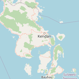
Map view of Rawa Aopa Watumohai National Park

Use this park location map to pinpoint Rawa Aopa Watumohai National Park in Indonesia, understand its exact geographic position, and read its mapped placement within the surrounding landscape more clearly.

Pigeon | © OpenStreetMap contributors

Location context for Rawa Aopa Watumohai National Park

South East Sulawesi
Park atlas

Discover surrounding landscapes and compare conservation efforts across the Sulawesi region

Explore Other National Parks and Protected Areas Near Rawa Aopa Watumohai National Park
Continue your protected area discovery by exploring other national parks and reserves located near Rawa Aopa Watumohai National Park on Sulawesi. Comparing these diverse landscapes provides valuable geographic context for understanding regional biodiversity and conservation priorities.
National parkSouth Sulawesi

Bantimurung-Bulusaraung National Park: National Park Protected Landscape Identity and Geographic Setting

Mapped boundaries and regional atlas context for this South Sulawesi park.

Bantimurung-Bulusaraung National Park is an important protected area in South Sulawesi, Indonesia, designated as a national park. This entry provides a focused look at its geographic scope, mapped outlines, and the characteristics that define it as a protected landscape. Understanding this park's specific terrain and regional setting is key to appreciating its role within the broader atlas of natural areas and conservation efforts.

Area
437 km²
Established
2004
IUCN
II
Visitors
600K annual
National parkWest Sulawesi

Gandang Dewata National Park: Protected Area Identity and Geographic Context in West Sulawesi

Explore mapped boundaries and regional landscape.

Delve into the protected landscape of Gandang Dewata National Park, a key national park situated in West Sulawesi. This resource offers a detailed geographic perspective, emphasizing its mapped boundaries and its position within the regional atlas. Understand the park's protected-area status and its contribution to the natural geography of Indonesia, serving as a vital point for atlas exploration.

Area
793.42 km²
Established
2016
IUCN
II
Relief
Mountain
National parkCentral Sulawesi

Lore Lindu National Park: Central Sulawesi's Protected Landscape and Atlas Anchor

Explore its endemic species, megalithic sites, and rich geography.

Lore Lindu National Park stands as a critical protected area within Central Sulawesi, Indonesia, recognized for its exceptional endemic biodiversity and profound archaeological importance. This national park features a dramatic geographic setting, rising from lowland forests to montane ecosystems and encompassing ancient megalithic structures within its protected landscape. Understanding Lore Lindu National Park through its mapped boundaries and unique regional geography offers deep insights into conservation and cultural heritage, providing a focal point for atlas-based discovery.

Area
2,180 km²
Established
1982
IUCN
II
Visitors
2K annual
National parkTojo Una-Una Regency

Kepulauan Togean National Park: Protected Marine Atlas and Island Landscape Geography

Explore Tojo Una-Una Regency's vital coral reef ecosystems and mapped island geography.

Kepulauan Togean National Park is a critically important marine protected area located within the Tojo Una-Una Regency of Indonesia. This national park is celebrated globally for its position at the center of the Coral Triangle, housing the most diverse array of coral species found anywhere on Earth. The park's landscape is defined by an archipelago of islands featuring a complex interplay of coral reefs, seagrass beds, and mangrove forests, creating a rich tapestry of marine habitats. Its geographic location also makes it a significant biogeographical crossroads, influencing the distribution of marine fauna between Asian and Australian regions.

Area
3,626 km²
Established
2004
IUCN
II
Relief
Lowland
National parkEast Nusa Tenggara

Kelimutu National Park: Volcanic Terrain and Colored Crater Lakes in East Nusa Tenggara

Explore the mapped geography of this unique Indonesian national park.

Kelimutu National Park represents a remarkable protected landscape in East Nusa Tenggara, Indonesia, distinguished by its volcanic origins and the famed three colored lakes of Mount Kelimutu. This national park protects diverse montane forests and offers a unique insight into the region's geological wonders. Its geography features volcanic slopes and the iconic caldera, making it a significant point of interest for atlas-driven exploration of protected natural areas.

Area
50 km²
Established
1992
IUCN
II
Visitors
12.5K annual
National parkEast Nusa Tenggara

Komodo National Park: National Park Protected Landscape Atlas Entry

Mapped boundaries and regional geography for this Indonesian protected area.

Delve into the atlas representation of Komodo National Park, an essential protected landscape within the East Nusa Tenggara region of Indonesia. This entry highlights the park's mapped boundaries and its distinctive geographic setting. Understand the park's role as a national park and its contribution to the structured exploration of protected areas and natural landscapes across the Lesser Sunda Islands.

Area
1,733 km²
Established
1980
IUCN
II
Visitors
45K annual
National parkSulawesi

Bogani Nani Wartabone National Park: A National Park Within Sulawesi's Geographic Atlas

Explore mapped protected landscape and regional terrain.

Bogani Nani Wartabone National Park represents a vital protected area within Sulawesi, Indonesia. This dedicated page provides an atlas-oriented view, focusing on its distinct landscape character, geographic placement, and mapped boundaries. Understand the park's role as a conservation landscape and how its terrain contributes to the regional geography, forming a crucial component of mapped natural areas.

Area
2,871.15 km²
Established
1991
IUCN
II
Climate
Tropical
National parkEast Nusa Tenggara

Manupeu Tanah Daru National Park: National Park Protected Landscape and East Nusa Tenggara Geography

Discover its mapped boundaries and regional atlas context.

Delve into the protected landscape of Manupeu Tanah Daru National Park, a significant national park situated within East Nusa Tenggara. This dedicated page provides detailed geographic context, focusing on the park's mapped boundaries and its contribution to the regional natural landscape. Understand its identity as a protected area and explore its place within the broader atlas of global conservation lands, fostering a deeper appreciation for its distinct geographic characteristics.

Area
879.84 km²
Established
1998
IUCN
II
Relief
Lowland

Common questions about visiting, size, designation, and location context for Rawa Aopa Watumohai National Park

Rawa Aopa Watumohai National Park FAQs for park facts, access, geography, and protected area context
Find quick answers about Rawa Aopa Watumohai National Park, including protected-area facts, park geography, trail and visitor context, and how the park fits into its surrounding country and regional landscape.
MoriAtlas Explorer

Continue Your Protected Areas Search Across the Global Atlas

Deepen your exploration by continuing the structured search for national parks and protected areas worldwide. Utilize the comprehensive filtering capabilities to compare different conservation landscapes and refine your understanding of global park geography. Discover more about the distribution and characteristics of protected natural areas.

Global natural geography