Mori Atlas logo
National parkBogani Nani Wartabone National Park

Discover the mapped terrain and regional context of this significant national park in Sulawesi.

Bogani Nani Wartabone National Park: Indonesia's Protected Landscape and Geographic Atlas

(Taman Nasional Bogani Nani Wartabone)

Bogani Nani Wartabone National Park stands as a distinct protected landscape within the island of Sulawesi, Indonesia. This page serves as your entry point to understanding its geographic identity, mapped boundaries, and role within the broader atlas of conservation areas. Delve into the regional terrain and protected area context that define this important national park, offering a foundation for detailed landscape exploration.

National ParkIndonesiaSulawesiEndemic WildlifeTropical ForestMaleo Megapode

Bogani Nani Wartabone National Park

National park

Park overview

Structured park overview, official facts, and landscape profile for Bogani Nani Wartabone National Park

Bogani Nani Wartabone National Park park facts, protected area profile, and essential visitor context
Review the core facts for Bogani Nani Wartabone National Park, including designation, size, terrain, visitor scale, habitats, and operating context in one park-focused overview.

About Bogani Nani Wartabone National Park

Bogani Nani Wartabone National Park represents one of Southeast Asia's most significant conservation landscapes, protecting extensive tracts of Sulawesi's remaining forest cover on the island's northern peninsula. The park's establishment in 1991 marked a critical step in preserving what remains of Sulawesi's once-vast lowland and montane forests, which have faced intense pressure from logging, agricultural expansion, and mining activities across the island. The subsequent renaming in 2004 to honor Nani Wartabone connected the park's conservation mission to the region's cultural heritage, recognizing the resistance fighter's pivotal role in the island's modern history.

The park's global significance stems from Sulawesi's unique position as a center of endemism, where millions of years of isolation have produced a distinctive fauna that shares lineage ties to both Asian and Australian continents yet has evolved into uniquely island forms. Bogani Nani Wartabone serves as the primary protected area for many of these endemic species, functioning as both a sanctuary for wildlife and a living laboratory for understanding island evolution and biogeography. The park's extensive altitudinal range supports multiple habitat types, from tropical lowland forests through montane zones, creating vertical stratification that further enhances species diversity within its boundaries.

Quick facts and research context for Bogani Nani Wartabone National Park

Bogani Nani Wartabone National Park covers 2,871 square kilometres on the Minahassa Peninsula of northern Sulawesi, making it one of Indonesia's largest national parks. The park was established in 1991 and reorganized in 2004, falling under the management of Indonesia's Ministry of Environment and Forestry. Located at approximately 0.56°N latitude and 123.68°E longitude, the park protects the core of Sulawesi's mountainous interior where the island's highest biodiversity concentrations occur. The park serves as the primary conservation stronghold for endemic Sulawesi species including the iconic maleo megapode, anoa, babirusa, and numerous bird species found nowhere else in the world.

Park context

Deeper park guide and search-rich context for Bogani Nani Wartabone National Park

Bogani Nani Wartabone National Park history, landscape, wildlife, and travel context
Explore Bogani Nani Wartabone National Park through its history, landscape character, ecosystems, wildlife, conservation priorities, cultural context, and seasonal travel timing in a structured park guide built for atlas discovery and search intent.

Why Bogani Nani Wartabone National Park stands out

Bogani Nani Wartabone is most renowned for its extraordinary concentration of endemic Sulawesi wildlife, particularly the maleo megapode which serves as the park's official mascot. This unusual bird, endemic solely to Sulawesi, breeds exclusively in the park's geothermal hot sand habitats, particularly at the Hungoyono camp in Bone Bolango where successful captive breeding and release programs have reintroduced approximately 3,300 birds to the wild. The park also protects critical populations of the endangered anoa, a small wild buffalo found only in Sulawesi, as well as the bizarre babirusa with its extraordinary tusks that grow upward through its snout. The 1999 scientific description of the cinnabar hawk owl from a specimen collected within the park boundaries further illustrates its role as a repository of undiscovered biodiversity.

Bogani Nani Wartabone National Park history and protected-area timeline

The park traces its institutional origins to 1991 when it was established as Dumoga Bone National Park, protecting portions of the Minahassa Peninsula's forest heritage. The initial protected area encompassed portions of what is now recognized as Sulawesi's most biodiverse region, but subsequent survey work and conservation assessment led to significant boundary expansions that reflected the true scale of biodiversity worth protecting. In 2004, the park was formally renamed Bogani Nani Wartabone National Park to honor Nani Wartabone, a legendary figure in Gorontalo province who led local resistance forces against Japanese occupation during World War II and successfully expelled the occupiers from the region in 1945.

The renaming acknowledged both the historical significance of the area and the park's role in protecting the natural heritage of the communities whose ancestors long inhabited these lands. The Wildlife Conservation Society's identification of the site as the single most important location for Sulawesi wildlife conservation validated decades of scientific research highlighting the area's irreplaceable biodiversity value. Subsequent conservation efforts have focused on addressing the threats of logging, poaching, and illegal gold mining while building partnerships with local communities to ensure sustainable protection of the park's natural resources.

Bogani Nani Wartabone National Park landscape and geographic character

Bogani Nani Wartabone National Park occupies the mountainous interior of the Minahassa Peninsula, the northernmost extension of Sulawesi island. The landscape is characterized by rugged terrain formed by the island's volcanic and tectonic history, with steep ridges, deep valleys, and remnant peaks that create a complex topographic mosaic. The park sits within a region of high rainfall that supports lush tropical forest cover across most elevations, though the specific vegetation communities vary with altitude and slope aspect. The Hungayono forest area exemplifies the park's typical lowland to mid-montane character, with dense canopy closure and diverse forest structure supporting the rich endemic fauna for which the park is renowned.

Bogani Nani Wartabone National Park ecosystems, habitats, and plant life

The park's ecological significance derives from the convergence of multiple biogeographic influences across Sulawesi's complex landscape. The forests of Bogani Nani Wartabone encompass a range of vegetation types adapted to the peninsula's climatic conditions, from semi-evergreen formations in lower elevations to mossy montane forests at higher altitudes. Common plant species documented within the park include Piper aduncum, Trema orientalis, and various Macaranga species, forming the structure of secondary forest communities that have regenerated following past disturbances. Orchids add to the botanical diversity, with numerous species adapted to the epiphytic lifestyle in the park's humid forest environment.

Several endangered plant species receive protection within the park's boundaries, including the matayangan palm Pholidocarpus ihur, Makassar Ebony Diospyros celebica valued for its decorative timber, iron wood from the genus Intsia, the medicinal yellow wood Arcangelisia flava, and the distinctive carrion flower Amorphophallus companulatus. These species face pressures from habitat loss outside protected areas, making the park's preservation function critical for their long-term survival.

Bogani Nani Wartabone National Park wildlife and species highlights

Bogani Nani Wartabone protects one of the most significant assemblages of endemic fauna in Southeast Asia, with documented populations including 24 mammal species, 11 reptile species, and 125 bird species. The park's flagship species is the maleo megapode, a remarkable bird endemic to Sulawesi that has evolved an unusual breeding strategy using geothermal hot sand to incubate its eggs. The maleo breeding program at Hungoyono camp in Bone Bolango represents one of Indonesia's most successful conservation initiatives, with over 3,300 birds released to natural habitat as of 2012. The park also supports populations of the endangered anoa, a dwarf buffalo species found only in Sulawesi, and the iconic babirusa whose males develop extraordinary upward-curving tusks.

The 1999 scientific description of the cinnabar hawk owl from specimens collected in the park demonstrates how much remains to be learned about Sulawesi's endemic wildlife. The Sulawesi warty pig represents another distinctive island form that inhabits the park's forests. This extraordinary concentration of endemic species, many of which occur nowhere else on Earth, makes Bogani Nani Wartabone a global priority for conservation investment and protection.

Bogani Nani Wartabone National Park conservation status and protection priorities

The identification of Bogani Nani Wartabone as the single most important site for Sulawesi wildlife conservation by the Wildlife Conservation Society reflects the park's irreplaceable role in protecting the island's endemic biodiversity. The park functions as the primary refuge for species that have evolved in isolation and cannot survive outside Sulawesi's forests, making the protected area essential for preventing extinctions in the face of ongoing habitat threats. Conservation challenges include uncontrolled logging that removes forest cover and fragments wildlife habitat, poaching of endangered species for trade or consumption, and illegal gold mining that degrades both terrestrial and aquatic ecosystems within the park boundaries.

The successful maleo breeding program demonstrates the potential for effective conservation action when adequate resources and community engagement are applied. Continued efforts to strengthen protection, address underlying drivers of habitat loss, and develop sustainable financing mechanisms will determine whether the park's extraordinary biodiversity can be preserved for future generations.

Bogani Nani Wartabone National Park cultural meaning and human context

The park's connection to Nani Wartabone, after whom it was renamed in 2004, reflects the deep historical ties between Sulawesi's communities and their landscape. Nani Wartabone led resistance against Japanese occupation during World War II and successfully liberated Gorontalo province, becoming a celebrated national hero whose legacy is now intertwined with the park's identity. The region surrounding the park has been inhabited for centuries by various ethnic groups whose traditional practices and land management systems shaped the landscape long before formal protected area designation. Local communities maintain connections to the park's forests through resource use, cultural practices, and ongoing conservation partnerships.

Top sights and standout views in Bogani Nani Wartabone National Park

Bogani Nani Wartabone National Park protects the most biodiverse forests in Sulawesi, home to endemic species found nowhere else on Earth including the maleo megapode, anoa, babirusa, and cinnabar hawk owl. The successful maleo breeding and release program has returned over 3,300 birds to their natural habitat in the park's geothermal sand breeding grounds. The park encompasses 2,871 square kilometres of forest on the Minahassa Peninsula, representing one of Indonesia's largest and most significant national parks. The park's 2004 renaming to honor resistance leader Nani Wartabone connects Sulawesi's natural and cultural heritage, celebrating both biodiversity and historical identity.

Best time to visit Bogani Nani Wartabone National Park

The park's equatorial location results in relatively consistent temperatures year-round, though visitor conditions vary with the regional rainy season typically running from November through March. Dry season months generally offer easier access to trail systems and more comfortable conditions for wildlife viewing, though the park's forest habitats remain lush and verdant throughout the year. The maleo breeding season aligns with specific environmental conditions related to geothermal activity, though guided visits to breeding areas are arranged through park management rather than independent exploration. Visitors interested in birdwatching and wildlife observation may find the transitional periods between seasons particularly rewarding as animal activity patterns shift with changing conditions.

Park location guide

Geography guide, regional context, and park location map for Bogani Nani Wartabone National Park

Bogani Nani Wartabone National Park park geography, regions, and map view in Indonesia
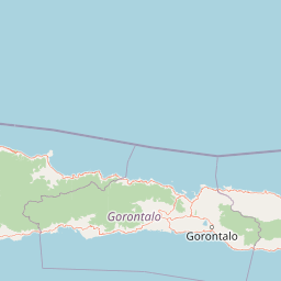
Understand where Bogani Nani Wartabone National Park sits in Indonesia through a broader geographic reading of the surrounding landscape, nearby location context, and its mapped position within the national park landscape.

How Bogani Nani Wartabone National Park fits into Indonesia

Indonesia is a vast archipelagic nation in Southeast Asia and Oceania, spanning over 17,000 islands between the Indian and Pacific Oceans. As the world's fourth-most populous country with 288 million people, it features extraordinary cultural and biological diversity, withJavanese and Sundanese being the largest ethnic groups. The country gained independence from the Netherlands in 1945 and operates as a unitary presidential republic.

Wider geography shaping Bogani Nani Wartabone National Park in Indonesia

Indonesia is situated in Southeast Asia and Oceania, spanning the equatorial region between the Indian Ocean to the west and the Pacific Ocean to the east. The archipelago includes major islands such as Sumatra, Java, Sulawesi, and parts of Borneo and New Guinea. It borders Papua New Guinea, Timor-Leste, and Malaysia by land, with extensive maritime boundaries throughout the region.

Map view of Bogani Nani Wartabone National Park

Use this park location map to pinpoint Bogani Nani Wartabone National Park in Indonesia, understand its exact geographic position, and read its mapped placement within the surrounding landscape more clearly.

Pigeon | © OpenStreetMap contributors

Location context for Bogani Nani Wartabone National Park

Sulawesi
Park atlas

Explore the geographic spread and diverse conservation landscapes surrounding this core protected area on Sulawesi

Discover Other National Parks and Protected Areas Near Bogani Nani Wartabone National Park, Sulawesi
After exploring Bogani Nani Wartabone National Park, continue your discovery by browsing other national parks and protected areas across Sulawesi and the broader Indonesian archipelago. Compare their unique protected landscapes, diverse endemic wildlife habitats, and distinct regional geographic contexts to deepen your atlas-style understanding of conservation efforts.
National parkNorth Sulawesi

Bunaken National Park: Indonesian National Park Geography and Mapped Boundaries

Explore North Sulawesi's protected marine landscape.

Bunaken National Park stands as a key protected area within Indonesia's North Sulawesi region, offering essential insights for geographic discovery and atlas exploration. This page focuses on the park's mapped boundaries and its identity as a national park, providing a structured view of its landscape context. Understand the distribution and significance of conservation areas in North Sulawesi through detailed, fact-based information.

Area
890.65 km²
Established
1991
IUCN
II
Visitors
35K annual
National parkTojo Una-Una Regency

Kepulauan Togean National Park: Protected Marine Atlas and Island Landscape Geography

Explore Tojo Una-Una Regency's vital coral reef ecosystems and mapped island geography.

Kepulauan Togean National Park is a critically important marine protected area located within the Tojo Una-Una Regency of Indonesia. This national park is celebrated globally for its position at the center of the Coral Triangle, housing the most diverse array of coral species found anywhere on Earth. The park's landscape is defined by an archipelago of islands featuring a complex interplay of coral reefs, seagrass beds, and mangrove forests, creating a rich tapestry of marine habitats. Its geographic location also makes it a significant biogeographical crossroads, influencing the distribution of marine fauna between Asian and Australian regions.

Area
3,626 km²
Established
2004
IUCN
II
Relief
Lowland
National parkCentral Sulawesi

Lore Lindu National Park: Central Sulawesi's Protected Landscape and Atlas Anchor

Explore its endemic species, megalithic sites, and rich geography.

Lore Lindu National Park stands as a critical protected area within Central Sulawesi, Indonesia, recognized for its exceptional endemic biodiversity and profound archaeological importance. This national park features a dramatic geographic setting, rising from lowland forests to montane ecosystems and encompassing ancient megalithic structures within its protected landscape. Understanding Lore Lindu National Park through its mapped boundaries and unique regional geography offers deep insights into conservation and cultural heritage, providing a focal point for atlas-based discovery.

Area
2,180 km²
Established
1982
IUCN
II
Visitors
2K annual
National parkNorth Maluku

Aketajawe-Lolobata National Park: Protected Landscape and Geographic Context in North Maluku

Explore the national park's mapped boundaries and regional setting.

Aketajawe-Lolobata National Park represents a significant protected area within North Maluku, Indonesia. This national park detail page provides focused insight into its geographic identity, allowing for exploration of its mapped boundaries and its role within the regional landscape context. Delve into the specifics of this Indonesian national park and its place in a structured atlas of protected lands.

Area
1,673 km²
Established
2004
IUCN
II
Relief
Mixed relief
National parkSouth East Sulawesi

Rawa Aopa Watumohai National Park: Geographic Atlas and Protected Landscape Overview

Explore Rawa Aopa Watumohai National Park's mapped boundaries.

Gain a clear understanding of Rawa Aopa Watumohai National Park, a designated national park in South East Sulawesi. This entry offers insight into its protected landscape identity, mapped geographic features, and its specific location within the regional atlas. It serves as a focused point for comprehending the park's protected area context and its contribution to Indonesian natural geography.

Area
1,050 km²
Established
1989
IUCN
II
Relief
Mixed relief
National parkWest Sulawesi

Gandang Dewata National Park: Protected Area Identity and Geographic Context in West Sulawesi

Explore mapped boundaries and regional landscape.

Delve into the protected landscape of Gandang Dewata National Park, a key national park situated in West Sulawesi. This resource offers a detailed geographic perspective, emphasizing its mapped boundaries and its position within the regional atlas. Understand the park's protected-area status and its contribution to the natural geography of Indonesia, serving as a vital point for atlas exploration.

Area
793.42 km²
Established
2016
IUCN
II
Relief
Mountain
National parkSabah

Tun Sakaran Marine Park National Park: Sabah Marine Archipelago Atlas

Explore the islands, sand cays, and coral reef geography.

Tun Sakaran Marine Park is a protected national park in Sabah, Malaysia, known for its stunning marine biodiversity and archipelago landscape. This atlas entry details the park's distinct islands, dynamic sand cays, and extensive coral reef systems within the Celebes Sea, offering insights into its unique geographic setting and ecological significance.

Area
101 km²
Established
2004
IUCN
II
Relief
Lowland
National parkEast Kalimantan

Kutai National Park: Protected Area Details and East Kalimantan Geography

Explore the mapped boundaries and regional landscape context.

Kutai National Park, a designated national park in Indonesia's East Kalimantan region, offers rich opportunities for geographic discovery. This resource focuses on the park's protected area status, its distinct landscape characteristics, and its mapped distribution within the broader regional geography. Gain a structured understanding of Kutai National Park's environmental significance and its contribution to conservation landscapes through detailed map context and geographic analysis.

Area
1,986 km²
Established
1982
IUCN
II
Relief
Lowland

Common questions about visiting, size, designation, and location context for Bogani Nani Wartabone National Park

Bogani Nani Wartabone National Park FAQs for park facts, access, geography, and protected area context
Find quick answers about Bogani Nani Wartabone National Park, including protected-area facts, park geography, trail and visitor context, and how the park fits into its surrounding country and regional landscape.
MoriAtlas Explorer

Continue Your Protected Areas Search Across the Global Atlas

Deepen your exploration by continuing the structured search for national parks and protected areas worldwide. Utilize the comprehensive filtering capabilities to compare different conservation landscapes and refine your understanding of global park geography. Discover more about the distribution and characteristics of protected natural areas.

Global natural geography
Bogani Nani Wartabone National Park: Protected Landscape & Geography Atlas