
Mori Atlas logo
Protected areaBinnensalzstelle am Kaliwerk Ronnenberg

Examining the ecological boundaries and industrial landscape context of a rare salt-influenced habitat in Region Hannover

Binnensalzstelle am Kaliwerk Ronnenberg: Analyzing the Geography of an Inland Saline Protected Area

The Binnensalzstelle am Kaliwerk Ronnenberg serves as a rare example of an inland saline habitat, shaped by the industrial legacy of a former potash mine in Lower Saxony. This protected area within the Region Hannover illustrates the complex relationship between mining spoil heaps and the development of specialized saline ecosystems far from the coast. Mapped boundaries define this small, ecologically significant strip where unique salt-tolerant vegetation thrives on terrain influenced by historical Zechstein-age salt deposits.

inland saline habitatBinnensalzstelleNatura 2000FFH-GebietLower SaxonyRegion Hannover
A flat-style vector illustration of a waterfall cascading down a large grey cliff into a river, surrounded by stylized trees and shrubs under a soft sun.

Binnensalzstelle am Kaliwerk Ronnenberg

Protected area

Park overview

Structured park overview, official facts, and landscape profile for Binnensalzstelle am Kaliwerk Ronnenberg

Binnensalzstelle am Kaliwerk Ronnenberg park facts, protected area profile, and essential visitor context

Review the core facts for Binnensalzstelle am Kaliwerk Ronnenberg, including designation, size, terrain, visitor scale, habitats, and operating context in one park-focused overview.

About Binnensalzstelle am Kaliwerk Ronnenberg

The Binnensalzstelle am Kaliwerk Ronnenberg is a small but ecologically distinctive protected area located in the Calenberger Lößbörde, a loess-rich lowland region south of Hannover. It belongs to the natural region known as the Hannoversche Börde, specifically the subunit called the Benther Land. Topographically, it sits at the foot of a low hill ridge that includes the locally known Gipsberg, which rises about 90 metres above sea level. The protected strip itself lies along the slope of the Abraumhalde, roughly 25 metres below the crest.

What makes the area unusual is its origin. It is not a natural saline spring or seep, but a so-called inland saline site that was created through industrial activity. The Kaliwerk Ronnenberg extracted potash from the Benther Salzstock, a deep salt structure stretching about eight kilometres underground from Ronnenberg through neighbouring communities toward western Hannover. The salts themselves originated in the Zechstein period, roughly 250 to 230 million years ago, when they were deposited from a shallow sea and later folded upward by tectonic movements about 160 million years ago.

When mining began in 1898 with the sinking of the Albert shaft, and especially after production ended with a major water inflow in the summer of 1975, the remaining spoil heap became a long-term source of saline drainage. Salts dissolved by rainwater are collected at the base in ring ditches, where sulphate salts predominate. This ongoing leaching is what sustains the inland saline habitat. Although the area is closed to visitors, the site illustrates how abandoned extractive landscapes can develop into ecologically valuable, highly specialized habitats that justify formal European protection.

Quick facts and research context for Binnensalzstelle am Kaliwerk Ronnenberg

The Binnensalzstelle am Kaliwerk Ronnenberg is a Natura 2000 / FFH protected area in the Region Hannover, Lower Saxony, in northwest Germany. It sits south of Ronnenberg along the edge of the Abraumhalde (spoil heap) of the former Kaliwerk Ronnenberg potash mine.

Its total protected area is approximately 1.5 to 1.7 hectares, extending around 600 metres along the southern and eastern margins of the heap. It was formally designated as an FFH area in 2004. Saline runoff from the heap is channeled via ring ditches and then diluted with fresh water before being piped roughly eight kilometres to the Fösse stream, delivering around twenty tonnes of salt per year into that watercourse.

Protection and recognition

Documented terrestrial protection scope, designation records, and international recognition sources

Binnensalzstelle am Kaliwerk Ronnenberg Protection Status and Natura 2000 Recognition

Binnensalzstelle am Kaliwerk Ronnenberg maintains a documented terrestrial protection status backed by official Natura 2000 recognition records. Structured atlas profiles assemble verified designation data and management parameters to clarify conservation frameworks without speculation.

International recognition

Protection details

Protection scope
Terrestrial
Transboundary protection
No
WDPA ID
555518960
Park context

Deeper park guide and search-rich context for Binnensalzstelle am Kaliwerk Ronnenberg

Binnensalzstelle am Kaliwerk Ronnenberg history, landscape, wildlife, and travel context

Explore Binnensalzstelle am Kaliwerk Ronnenberg through its history, landscape character, ecosystems, wildlife, conservation priorities, cultural context, and seasonal travel timing in a structured park guide built for atlas discovery and search intent.

Why Binnensalzstelle am Kaliwerk Ronnenberg stands out

The site is best known for being an inland saline habitat, a Binnensalzstelle, that was unintentionally created by human industrial activity. Salt-bearing runoff from the abandoned potash mine's spoil heap produces a localized saline environment where species typically associated with coastal salt marshes can persist far from the sea. This combination of industrial heritage, very small protected size, and ecologically unusual saline character makes it one of the rare examples of mine-related saline habitats included in the European Natura 2000 network.
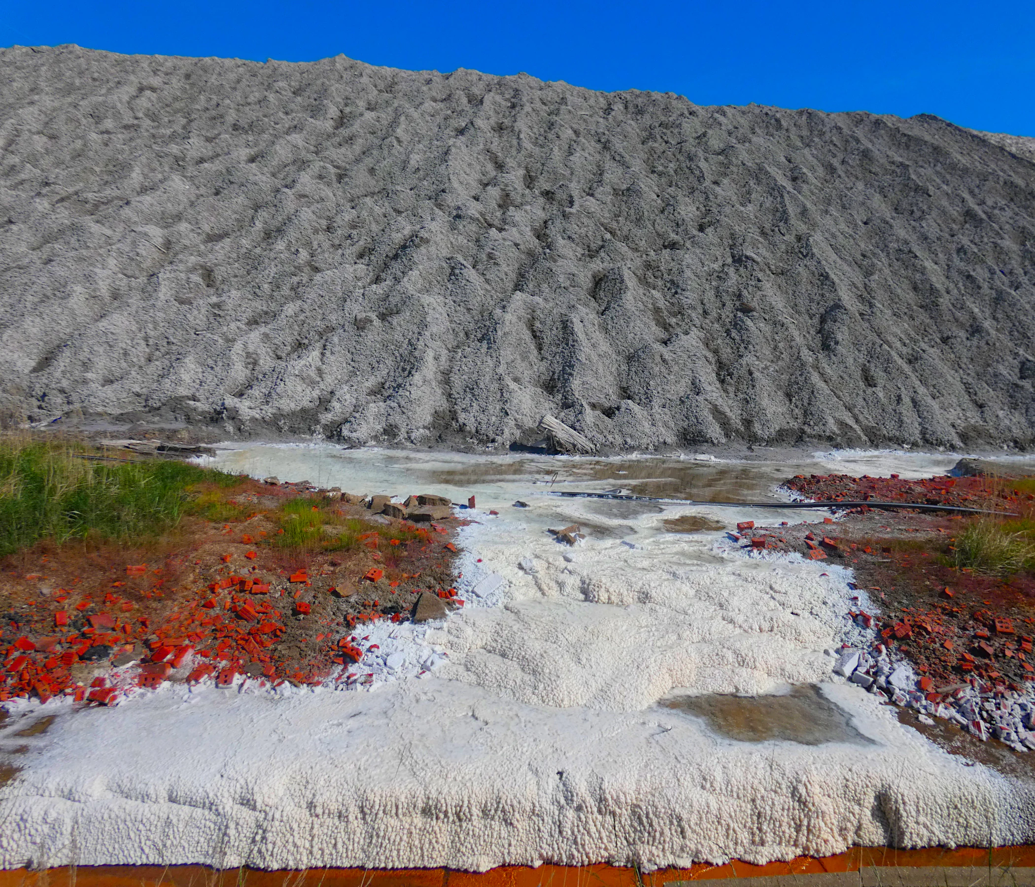
A wide, textured grey waste pile rises behind a foreground of salt deposits and red-colored vegetation.
A salt marsh area near the potash mine tailings pile in Ronnenberg, Germany.

Binnensalzstelle am Kaliwerk Ronnenberg history and protected-area timeline

Mining at the Kaliwerk Ronnenberg began with the sinking of the Albert shaft on 28 March 1898. The construction itself was repeatedly interrupted by water inflows, and regular extraction did not start until late 1905. Over the following decades, more than 40 million tonnes of material were brought to the surface and processed in an on-site plant. The unwanted fraction, roughly 90 percent of which consisted of rock salt, was dumped on a heap south of the shaft.

Eventually, after a severe water inflow in the summer of 1975, the mine was flooded and abandoned. Part of the spoil heap was later removed, but the remaining stump of the deposit continued to leach salts whenever it rained. Drainage water was, and still is, collected in ring ditches at the foot of the heap, primarily depositing sulphate salts. The dense brine is diluted with fresh water and pumped roughly eight kilometres through a pipeline to the Fösse stream, sending around twenty tonnes of salt per year into that watercourse.

In 2004, the narrow strip of land along the southern and eastern edge of the heap, covering roughly 1.47 hectares over about 600 metres, was formally designated as a protected FFH (Habitats Directive) site. Public access to the area is prohibited by the Oberbergamt Clausthal. The site is one of only two FFH areas within Ronnenberg's municipal territory, and a comparable inland saline habitat at the Kaliwerk Hansa in the Empelde district has effectively disappeared due to ongoing recultivation of its spoil heap.

Binnensalzstelle am Kaliwerk Ronnenberg landscape and geographic character

The protected area lies within the gently rolling topography of the Calenberger Lößbörde, a loess plain south of Hannover that forms part of the wider Lower Saxon Börde. A modest hill ridge rises southeast of Ronnenberg and culminates in the Gipsberg, which reaches about 90 metres in elevation. The protected strip follows the lower slope of this ridge, sitting roughly 25 metres below the summit, where the land drops away toward the west.

The dominant landscape feature, however, is not a natural landform but the Abraumhalde of the former mine. This artificial mound, built up from decades of mining waste, defines both the topography and the ecology of the protected zone. The protected strip runs about 600 metres along its southern and eastern margins. Because of the way saline water collects and evaporates at the foot of the mound, salt deposits regularly crystallize on and around the heap, giving even the spoil tip itself a visibly whitish saline crust in places.

Binnensalzstelle am Kaliwerk Ronnenberg ecosystems, habitats, and plant life

From an ecological standpoint, the Binnensalzstelle is a classic example of a habitat that is rare in inland Central Europe. In most of Germany, true saline conditions occur only along the coast, in salt marshes influenced by seawater. Here, however, salts of deep geological origin, leached from the potash-bearing layers of the Benther Salzstock, emerge at the surface through a man-made substrate.

This produces a miniature analogue of coastal salt environments. Vegetation adapted to saline, nutrient-poor, and often waterlogged conditions can establish around the ring ditches where brines collect and partially evaporate. The resulting habitat belongs to the group of inland saline communities, InlandSal, and stands out sharply from the surrounding loess soils, which would normally support very different, non-saline plant communities.

Because the area is small and enclosed by intensivel-cultivated farmland, its ecological significance lies less in scale than in representativeness. It preserves genetic resources and ecological processes that would otherwise be absent from this part of Lower Saxony, acting as a refuge for the flora and fauna of saline habitats in a region hundreds of kilometres from the nearest coast.

Binnensalzstelle am Kaliwerk Ronnenberg wildlife and species highlights

The protected site's distinctive wildlife interest comes from the species that depend on saline conditions rather than from large mammals or charismatic fauna. Salt-tolerant vegetation around the ring ditches and heap edges forms the base of a highly specialized food web.

Because inland saline habitats are extremely localized in Germany, the Binnensalzstelle acts as a small, isolated refuge for halophytic plants and the invertebrate communities associated with them. These specialist invertebrates in turn support birds and other animals that feed on them. The site's formal recognition as an FFH (Habitats Directive) area indicates that at least one habitat type listed under the EU Habitats Directive is present in a favourable enough condition to justify conservation.

Specific named species are not described in detail in the available source material, so this section focuses on the ecological role of the site rather than on a species inventory.

Binnensalzstelle am Kaliwerk Ronnenberg conservation status and protection priorities

The Binnensalzstelle am Kaliwerk Ronnenberg is formally protected as part of the European Natura 2000 network under the EU Habitats Directive (FFH). It carries the Natura 2000 site identifier 3623-331 and the World Database on Protected Areas identifier 555518960. The site's protected status was established in 2004, when the narrow strip along the heap was designated as an FFH area covering approximately 1.47 hectares.

Its conservation value is unusual because it rests on a habitat type, inland saline environments, that is naturally very rare in inland Germany. The site preserves an example of these communities in a landscape context, the Lower Saxon Börde, where they would not otherwise occur. The saline runoff is, in a sense, both the conservation challenge and the conservation asset: it keeps the habitat in existence but also prevents public access because of the mine-related hazards. Access is formally restricted by the Oberbergamt Clausthal, the regional mining authority, on grounds of residual mining risk rather than ecological fragility alone.

The protected area is also notable as one of only two remaining FFH sites within the municipal area of Ronnenberg, alongside a forested site called the Linderter und Stamstorfer Holz. A former comparable inland saline habitat at the Kaliwerk Hansa in the Empelde district has effectively been lost due to recultivation of its spoil heap, which underlines the conservation responsibility carried by the surviving Ronnenberg site.

Top sights and standout views in Binnensalzstelle am Kaliwerk Ronnenberg

Tightly bounded by farmland, the Binnensalzstelle packs several remarkable features into a very small footprint: a direct geological connection to Zechstein-age marine salt deposits through the Benther Salzstock; a hundred-year industrial history from shaft sinking in 1898 to flooding in 1975; and an ongoing active ecological process, with roughly twenty tonnes of salt still being leached annually into the Fösse via an eight-kilometre pipeline.

Its small size, formal Natura 2000 designation since 2004, and rarity within the surrounding Börde landscape make it a concentrated example of how industrial heritage and ecological rarity can overlap. The visibly saline crusts on the spoil heap, observed in photographs of the site, are perhaps the most immediately striking visual signature of this unusual habitat.

Monthly climate preview

Long-term representative temperature ranges and monthly precipitation averages

Binnensalzstelle am Kaliwerk Ronnenberg Climate Normals and Annual Weather Patterns

Binnensalzstelle am Kaliwerk Ronnenberg records measured mean monthly temperatures spanning from near freezing to warm summer maximums alongside steady precipitation rates. Reviewing the complete twelve-month climatology data provides deeper insight into long-term environmental rhythms at the representative coordinate.
Annual mean9 °C
1 °C18 °C
Jan
Feb
Mar
Apr
May13°
Jun16°
Jul18°
Aug18°
Sep14°
Oct10°
Nov
Dec
Warmest month
July

18.4 °C

Coolest month
January

0.6 °C

Wettest month
July

2.4 mm/day

Driest month
April

1.4 mm/day

Park location guide

Geography guide, regional context, and park location map for Binnensalzstelle am Kaliwerk Ronnenberg

Binnensalzstelle am Kaliwerk Ronnenberg park geography, regions, and map view in Germany

Understand where Binnensalzstelle am Kaliwerk Ronnenberg sits in Germany through a broader geographic reading of the surrounding landscape, nearby location context, and its mapped position within the national park landscape.

How Binnensalzstelle am Kaliwerk Ronnenberg fits into Germany

Germany is a federal republic in Western and Central Europe with a population of over 83 million across sixteen constituent states. It is Europe's largest economy by nominal GDP and a major global exporter and importer. The capital is Berlin, and the country borders Denmark, Poland, Czech Republic, Austria, Switzerland, France, Luxembourg, Belgium, and the Netherlands.

Wider geography shaping Binnensalzstelle am Kaliwerk Ronnenberg in Germany

Germany is located in Western and Central Europe, spanning 357,022 km². It borders Denmark to the north, Poland and the Czech Republic to the east, Austria and Switzerland to the south, and France, Luxembourg, Belgium, and the Netherlands to the west. The country has coastlines on the Baltic Sea and North Sea to the north, with the Alps located in the southern region.

Map view of Binnensalzstelle am Kaliwerk Ronnenberg

Use this park location map to pinpoint Binnensalzstelle am Kaliwerk Ronnenberg in Germany, understand its exact geographic position, and read its mapped placement within the surrounding landscape more clearly.

Pigeon | © OpenStreetMap contributors

Location context for Binnensalzstelle am Kaliwerk Ronnenberg

Region Hannover

Visualizing rare inland saline habitats, industrial spoil heaps, and specialized park terrain.

Binnensalzstelle am Kaliwerk Ronnenberg Photos and Protected Area Landscape Scenery

Examine detailed photographs capturing the unique saline crusts, industrial topography, and specialized vegetation defining Binnensalzstelle am Kaliwerk Ronnenberg. Visual records reveal the distinct environmental character of this protected inland ecosystem more clearly than maps alone.

A wide, textured grey waste pile rises behind a foreground of salt deposits and red-colored vegetation.

Park atlas

Compare surrounding regional geography and adjacent protected areas in Lower Saxony

Parks Near Binnensalzstelle am Kaliwerk Ronnenberg: Related Protected Landscapes

Browse nearby national parks and protected areas sharing the wider geography of the surrounding region. Comparing adjacent natural habitats helps place rare inland saline ecosystems into broader regional context.
Nature reserveRegion Hannover
About 6 km away#1 closest

East

Sundern Nature Reserve and Floodplain Forest Landscapes of Region Hannover

Historic river meander and alluvial habitat preservation

Sundern represents a critical fragment of the historic Leine river floodplain in the Region Hannover. This nature reserve features a complex mosaic of moist backwaters and dry deciduous woodlands, including old-growth oak-hornbeam stands. The area is defined by its glacial valley setting, where centuries of sediment accumulation have shaped a distinct, slightly elevated landscape mosaic that remains vital for regional conservation.

Area
0.504 km²
Established
1931
IUCN
IV
Relief
Lowland
A soft watercolor illustration of a river winding through a green floodplain with rolling hills in the background.
Nature reserveRegion Hannover
7.7 km away#2 closest

East

Leineaue zwischen Hannover und Ruthe: Protected Floodplain and River Geography

Nature reserve geography and alluvial habitat mapping.

Examine the topographic and hydrological features of the Leineaue zwischen Hannover und Ruthe nature reserve. This atlas entry provides insights into the site's dual-channel river structure, calcareous tufa springs, and fragmented alluvial woodlands that define this significant conservation area near Hannover.

Area
9.678 km²
Established
2007
Relief
Lowland
Scope
Terrestrial
Protected areaRegion Hannover
13 km away#3 closest

Northwest

Mausohr-Wochenstube bei Barsinghausen: Protected Habitat and Regional Landscape Context

A vital Natura 2000 maternity site in Region Hannover

Examine the geography of Mausohr-Wochenstube bei Barsinghausen, an essential protected area for greater mouse-eared bats. This site showcases the intersection of architectural heritage and natural conservation, relying on the adjacent river corridors and agricultural landscapes of the Region Hannover to sustain its vital ecological function within Lower Saxony.

Area
0.001 km²
Established
2004
Relief
Lowland
Climate
Temperate
Nature reserveLower Saxony
About 13 km away#4 closest

South

Zigeunerwäldchen Nature Reserve: A Detailed Geographic Atlas of the Haller River Floodplain

Protected riparian forest boundaries in Lower Saxony

Zigeunerwäldchen is a protected nature reserve in Lower Saxony that preserves a vital fragment of the Haller river floodplain. The landscape is defined by willow-dominated alluvial forest, marshy clearings, and thick stands of sedge. By maintaining these natural water-influenced terrains, the reserve provides a rare glimpse into the historical floodplain architecture of the Calenberger Land region.

Area
0.15 km²
Established
1986
Nature reserveGermany
About 17 km away#5 closest

West

Walterbachtal Nature Reserve: A Detailed Geographic Atlas of the Deister Stream Valley

Mapping protected meadow and forest landscapes in Germany

Walterbachtal offers a unique look at small-scale conservation in the Weserbergland. This nature reserve protects a dynamic stream, traditional wet meadows, and oak-hornbeam forests that thrive on the slopes of the Deister. The reserve provides a distinct transition between aquatic and terrestrial zones, serving as a critical corridor for biodiversity in the regional landscape between Hannover and Hameln.

Area
0.32 km²
Established
1987
IUCN
IV
Relief
Upland
Natural monumentRheinland-Pfalz
About 17 km away#6 closest

South

Steinbruch Holzmühle Natural Monument: Protected Limestone Landscapes and Geological Map

Mapping the geological strata and amphibian habitats of the Osterwald hills.

Investigate the geological significance and managed ecological profile of Steinbruch Holzmühle. This site features preserved Kimmeridgian limestone formations and restored habitats that provide a unique case study in post-industrial conservation within the local regional hill network.

A wide panoramic watercolor illustration showing a winding river or stream flowing through a landscape of green pine trees and pink flowering bushes under a pale sky.
Nature reserveRegion Hannover
About 17 km away#7 closest

Northwest

Wadebruch Nature Reserve: Geographic Analysis of a Lower Leine Floodplain Protected Area

A dense mosaic of alder swamps, oxbow channels, and sandy terrace forest in Germany.

Wadebruch serves as a compact, ecologically rich example of a lower Leine floodplain environment. Located in the Hannover Region, this protected site preserves a historic river meander, including an aging oxbow and alder swamp forest, contrasted against steep sandy banks. The site provides essential insights into the natural river patterns that once characterized this part of Lower Saxony.

Area
0.16 km²
Established
1985
IUCN
IV
Relief
Lowland
A minimalist watercolor painting featuring soft green, yellow, and purple tones depicting a rolling hill landscape with trees and distant hills.
Nature reserveNiedersachsen
21 km away#8 closest

Southeast

Haseder Busch, Giesener Berge, Gallberg, Finkenberg Protected Landscape and Map Data

A diverse hill and floodplain ecosystem in Niedersachsen, Germany.

Trace the ecological boundaries and terrain of this expansive nature reserve. The site features a rare convergence of Triassic sedimentary landscapes, including the northernmost calcareous semi-dry grasslands and beech forests in the region, alongside historic floodplain meadows shaped by the Innerste river.

Area
7.42 km²
Established
2019

Common questions about visiting, size, designation, and location context for Binnensalzstelle am Kaliwerk Ronnenberg

Binnensalzstelle am Kaliwerk Ronnenberg FAQs for park facts, access, geography, and protected area context

Find quick answers about Binnensalzstelle am Kaliwerk Ronnenberg, including protected-area facts, park geography, trail and visitor context, and how the park fits into its surrounding country and regional landscape.
MoriAtlas Explorer

Continue Your Protected Areas Search Across the Global Atlas

Deepen your exploration by continuing the structured search for national parks and protected areas worldwide. Utilize the comprehensive filtering capabilities to compare different conservation landscapes and refine your understanding of global park geography. Discover more about the distribution and characteristics of protected natural areas.

Global natural geography