
Mori Atlas logo
Nature reserveLeineaue zwischen Hannover und Ruthe

A detailed look at the dual-channel river system, calcareous springs, and alluvial terrain.

Leineaue zwischen Hannover und Ruthe: Mapped Protected Floodplain Landscapes and Geography

(Naturschutzgebiet Leineaue zwischen Hannover und Ruthe)

Leineaue zwischen Hannover und Ruthe stands as a protected floodplain corridor along the Leine river, featuring a complex mosaic of softwood and hardwood alluvial forests, species-rich lowland meadows, and unique tufa-forming calcareous springs. This nature reserve, situated within the Region Hannover corridor, preserves a critical hydrological gradient ranging from active river channels to stable terrace woodlands. The area provides essential habitats for species including the European beaver, Eurasian otter, and greater mouse-eared bat, serving as a primary example of large-scale habitat conservation near a metropolitan center.

floodplainalluvial forestcalcareous springsriverine habitatwet meadowFFH site
A flat-style digital illustration showing a winding river flowing through a valley toward a waterfall in the distance, set against mountains under a soft sun.

Leineaue zwischen Hannover und Ruthe

Nature reserve

Park overview

Structured park overview, official facts, and landscape profile for Leineaue zwischen Hannover und Ruthe

Leineaue zwischen Hannover und Ruthe park facts, protected area profile, and essential visitor context

Review the core facts for Leineaue zwischen Hannover und Ruthe, including designation, size, terrain, visitor scale, habitats, and operating context in one park-focused overview.

About Leineaue zwischen Hannover und Ruthe

Leineaue zwischen Hannover und Ruthe represents one of the more ecologically diversified floodplain landscapes in Lower Saxony, where the Leine river transitions from its upper catchment into the broader North German plain. The protected area stretches across roughly 968 hectares, weaving through municipalities in the Region Hannover and into the Landkreis Hildesheim. It is simultaneously a European FFH site, an overlapping geometry of two older nature reserves, and, since 2021, a nationally designated nature reserve in its own right.

The landscape reads as a layered floodplain: active channels of the Leine alternate with the older, more meandering course known as the Alte Leine. Riverbanks are lined with tall-herb communities and remnants of softwood and hardwood alluvial forest, while the slightly higher terraces support oak-hornbeam woodland and beech forest on more mesic soils. In several places, former extraction pits have filled with groundwater and now hold standing-water communities dominated by pondweeds and frogbit, adding lentic habitat to an otherwise lotic system.

Geologically, the most distinctive feature is the presence of calcareous tufa (Kalktuff) springs along terrace edges, where carbonate-rich groundwater emerges and precipitates mineral deposits. These spring habitats, rare in the regional context, anchor the calcareous character of the floodplain and create conditions for specialized vegetation. Beyond these natural features, part of the protected area overlaps with water-supply grounds used for drinking-water extraction, which adds a layer of land-use complexity to the conservation setting.

The site sits within the broader network of protected flooding landscapes of the Hannover region and contributes directly to the connectivity of habitats along the Leine valley. It links to the neighbouring FFH complexes of the lower Aller, lower Oker, and adjacent calcareous woodland sites, reinforcing the ecological coherence of the wider river landscape.

Quick facts and research context for Leineaue zwischen Hannover und Ruthe

Leineaue zwischen Hannover und Ruthe lies on the lower reaches of the Leine river in Lower Saxony, extending across the Region Hannover and the Landkreis Hildesheim. The protected area was first proposed as an FFH site in January 2005 and formally designated in November 2007 under the Natura 2000 code DE3624-331. It overlaps with two pre-existing nature reserves and part of a larger landscape protection area along the upper Leine, and was elevated to a national Naturschutzgebiet on 29 April 2021. The site combines alluvial woodland, calcareous tufa springs, standing waters, and lowland meadows, and is considered important habitat for the European beaver, Eurasian otter, greater mouse-eared bat, and northern crested newt.

Protection and recognition

Documented terrestrial protection scope, management records, and Natura 2000 listings.

Leineaue zwischen Hannover und Ruthe Protection Status and International Recognition

Terrestrial protection status, management scope, and official international designations define the conservation framework for Leineaue zwischen Hannover und Ruthe. Documented recognition sources such as Natura 2000 establish verifiable administrative records for the protected landscape.
Park context

Deeper park guide and search-rich context for Leineaue zwischen Hannover und Ruthe

Leineaue zwischen Hannover und Ruthe history, landscape, wildlife, and travel context

Explore Leineaue zwischen Hannover und Ruthe through its history, landscape character, ecosystems, wildlife, conservation priorities, cultural context, and seasonal travel timing in a structured park guide built for atlas discovery and search intent.

Why Leineaue zwischen Hannover und Ruthe stands out

The site is best known as a richly structured floodplain corridor on the lower Leine, where fragmented alluvial forests, tufa-forming calcareous springs, and former-extraction standing waters coexist within a single Natura 2000 designation. Its importance for the greater mouse-eared bat colonies near Rössing and Hildesheim, along with confirmed populations of beaver and otter, gives the area a broader mammal-conservation profile that extends beyond its botanical and habitat values.
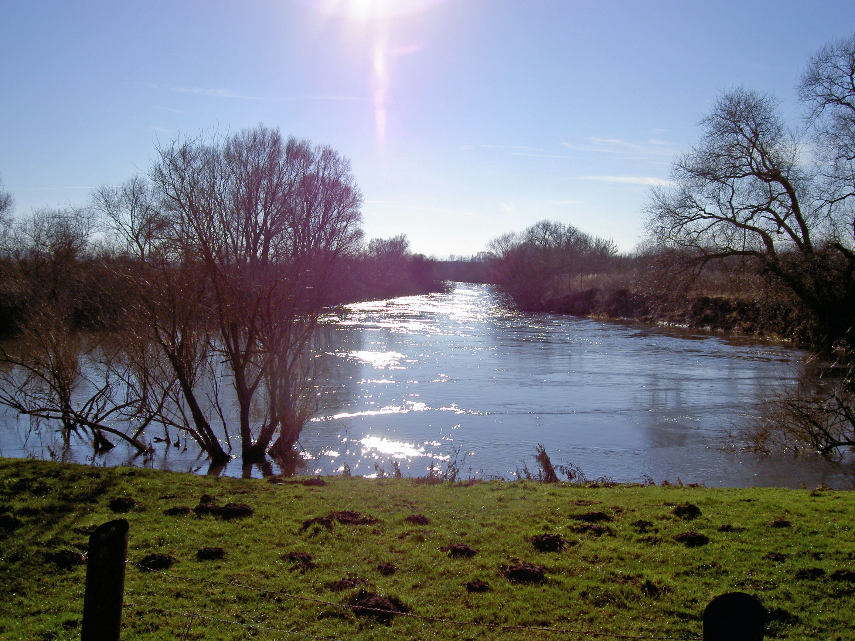
A wide view of the Leine river on a clear, sunny winter day with leafless trees standing along the bank and sunlight reflecting on the water.
The Leine river flowing through the nature reserve near Ruthe during winter.

Leineaue zwischen Hannover und Ruthe history and protected-area timeline

The protected landscape of Leineaue zwischen Hannover und Ruthe emerged from a layered process of European, regional, and national designation. In January 2005 the area was proposed as a candidate Fauna-Flora-Habitat site under the European Union's Habitats Directive, and in November 2007 this designation was formally confirmed, assigning the site the Natura 2000 code DE3624-331.

Before the European designation, parts of the same floodplain had already been recognised at the regional level. The site overlaps almost entirely with the older nature reserve Leineaue zwischen Ruthe und Koldingen, catalogued as NSG HA 203, as well as with the nature reserve Alte Leine (NSG HA 191), and shares perimeter with sections of the landscape protection area Obere Leine. These predecessors established early years of formal protection along the same stretch of river course.

On 29 April 2021, the FFH area was elevated to a national Naturschutzgebiet under the name Leineaue zwischen Hannover und Ruthe. This step consolidated the overlapping European and regional designations into a single, nationally enforceable protection regime, providing the legal backbone for habitat management across the full mosaic of alluvial forest, spring, meadow, and standing-water communities described in the FFH documentation.

Leineaue zwischen Hannover und Ruthe landscape and geographic character

The defining landscape feature of Leineaue zwischen Hannover und Ruthe is the floodplain corridor of the Leine river as it approaches the North German plain. The active river channel winds through the reserve alongside older, partially re-naturalised stretches of the Alte Leine, creating a dual-thread river system with contrasting flow regimes. Between these channels sit flat alluvial surfaces shaped by repeated flooding, occasionally interrupted by low terraces marking older floodplain levels.

Along the higher terrace edges emerge a series of calcareous tufa springs, a relatively unusual feature in this part of Lower Saxony. The carbonate-rich groundwater that surfaces here deposits tufa and supports specialised spring vegetation, lending parts of the floodplain a calcareous character unusual for the broader region. Together with riverbanks and former extraction sites, these springs punctuate the otherwise alluvial setting.

In the southern portions of the reserve, the terrain rises gently onto more stable ground where oak-hornbeam and beech woodland have developed on mesic soils. This vertical layering, from active river and tufa spring through alluvial forest to higher deciduous woodland, gives the site a clearly readable topographic and hydrological gradient within a relatively compact area.

Leineaue zwischen Hannover und Ruthe ecosystems, habitats, and plant life

Ecologically, Leineaue zwischen Hannover und Ruthe is defined less by any single habitat than by the close coexistence of several normally separated habitat types. Fragmentary softwood and hardwood alluvial forests remain along the active floodplain, while tall-herb communities line the riverbanks. The Alte Leine adds a more slowly flowing, vegetation-rich channel in which the river itself is a habitat rather than just a setting.

Still waters created by historic mineral extraction contribute a second ecological axis. These standing-water bodies have developed diverse aquatic vegetation including pondweed and frogbit communities, and they increase habitat diversity in what would otherwise be a purely riverine landscape. On the slightly higher terraces, drier woodland types including oak-hornbeam and beech forest extend the habitat spectrum further.

The overall vegetation mosaic thus spans open species-rich lowland meadows, floodplain meadows, tall-herb riverside vegetation, several alluvial forest types, wet and mesic woodland, karstic calcareous springs, flowing waters with submerged aquatic plants, and nutrient-rich still waters. This breadth of habitat types within a relatively small floodplain area is one of the site's defining ecological characteristics.

Leineaue zwischen Hannover und Ruthe wildlife and species highlights

The protected area supports a mammal, bat, and amphibian community that reflects both the diversity of habitats and the riverine character of the floodplain. The European beaver (Castor fiber) is present along the Leine and Alte Leine, where the combination of woody banks and quiet water provides typical beaver habitat. The Eurasian otter (Lutra lutra) is also recorded, indicating that the aquatic continuum through the protected area remains functional as a movement and hunting corridor.

The greater mouse-eared bat (Myotis myotis) is the third headline mammal of the reserve. Part of the protected perimeter overlaps with water-supply grounds and other open terrain that function as foraging habitat for the maternity colonies of this species near the village of Rössing and around Hildesheim. The inclusion of these areas within the reserve connects roosting sites in surrounding settlements with a high-quality foraging landscape.

Among amphibians, the northern crested newt (Triturus cristatus) is recorded as a species of conservation interest, reflecting the value of the standing waters created by former extraction for amphibian breeding. Together, these species give the floodplain a mammal- and amphibian-focused wildlife profile that complements its strictly botanical and habitat-level designations.

Leineaue zwischen Hannover und Ruthe conservation status and protection priorities

From a conservation perspective, the site matters primarily because it consolidates an unusually rich floodplain habitat complex under a single formal designation, spanning European, regional, and national levels. As an FFH area, it contributes directly to the European Natura 2000 network and supports habitat types and species listed under the EU Habitats Directive. Its national nature reserve status, granted in April 2021, layers stricter national protection on top of the European framework.

Conservation value arises from the convergence of several habitat types that would normally occur in separate sites: alluvial forest fragments of both softwood and hardwood types, calcareous tufa springs, standing waters with well-developed aquatic vegetation, species-rich lowland meadows, and tall-herb riverside communities. Each of these is in decline across much of central Europe due to floodplain drainage, river straightening, agricultural intensification, and groundwater abstraction, making their joint survival in one floodplain site regionally significant.

The site's role in mammal conservation is similarly meaningful. Beaver, otter, greater mouse-eared bat, and northern crested newt are all species for which the Leine valley forms an important refugium. By protecting both their aquatic and terrestrial habitats, including the bat foraging grounds around Rössing and Hildesheim, the reserve helps maintain breeding populations and movement corridors in the densely populated Hannover-Hildesheim corridor.

Leineaue zwischen Hannover und Ruthe cultural meaning and human context

The cultural context of the reserve is closely tied to the long human shaping of the Leine valley. The floodplain has long been used for agriculture, and the open meadows and arable land still embedded in the landscape reflect centuries of grassland management and floodplain farming. The historic straightening and re-meandering of the Leine channel and its older counterpart, the Alte Leine, also bear the imprint of water-management history typical of densely settled lowland Germany.

The former mineral extraction sites now absorbed into the protected area introduce a more recent layer of cultural landscape, where industrial land use has been succeeded by ecological regeneration. In addition, the presence of water-supply infrastructure serving the wider Hannover region illustrates how the floodplain continues to function as a working landscape for drinking-water production alongside its conservation role, requiring an integrated management approach between utility providers and nature conservation authorities.

Top sights and standout views in Leineaue zwischen Hannover und Ruthe

Among the site's most notable features are its dual-channel river structure of Leine and Alte Leine, the rare calcareous tufa springs along terrace edges, and the standing waters created by former mineral extraction that now support diverse aquatic vegetation. The combination of softwood and hardwood alluvial forest fragments, oak-hornbeam and beech woodland on the terraces, and species-rich lowland meadows gives the floodplain a habitat density rarely found in such proximity to a major German metropolitan region.

Best time to visit Leineaue zwischen Hannover und Ruthe

The Leine floodplain between Hannover and Ruthe is best appreciated in the warmer months when meadow vegetation is at its richest and wildflowers in the species-rich lowland meadows and riverside tall-herb communities are in bloom. Late spring and early summer typically offer the clearest contrast between actively flowing river reaches, more vegetated stretches of the Alte Leine, and reed-fringed standing waters. Winter and early spring reveal the open structure of the floodplain and are well suited to observing waterbirds and any surface activity along the still waters, though aquatic vegetation retreats and many meadows lie dormant in this season.

Monthly climate preview

Long-term representative temperature and precipitation patterns across the conservation landscape

Leineaue zwischen Hannover und Ruthe Climate Normals and Weather by Month

Historical climate data for Leineaue zwischen Hannover und Ruthe reveals measured monthly averages spanning sub-zero winter lows to warm summer maximums alongside consistent daily precipitation rates. Examining the full twelve-month profile provides deeper analytical context for long-term regional weather patterns at the representative coordinate.
Annual mean9 °C
0 °C19 °C
Jan
Feb
Mar
Apr
May13°
Jun16°
Jul19°
Aug18°
Sep14°
Oct
Nov
Dec
Warmest month
July

18.5 °C

Coolest month
January

0.4 °C

Wettest month
July

2.5 mm/day

Driest month
April

1.4 mm/day

Park location guide

Geography guide, regional context, and park location map for Leineaue zwischen Hannover und Ruthe

Leineaue zwischen Hannover und Ruthe park geography, regions, and map view in Germany

Understand where Leineaue zwischen Hannover und Ruthe sits in Germany through a broader geographic reading of the surrounding landscape, nearby location context, and its mapped position within the national park landscape.

How Leineaue zwischen Hannover und Ruthe fits into Germany

Germany is a federal republic in Western and Central Europe with a population of over 83 million across sixteen constituent states. It is Europe's largest economy by nominal GDP and a major global exporter and importer. The capital is Berlin, and the country borders Denmark, Poland, Czech Republic, Austria, Switzerland, France, Luxembourg, Belgium, and the Netherlands.

Wider geography shaping Leineaue zwischen Hannover und Ruthe in Germany

Germany is located in Western and Central Europe, spanning 357,022 km². It borders Denmark to the north, Poland and the Czech Republic to the east, Austria and Switzerland to the south, and France, Luxembourg, Belgium, and the Netherlands to the west. The country has coastlines on the Baltic Sea and North Sea to the north, with the Alps located in the southern region.

Map view of Leineaue zwischen Hannover und Ruthe

Use this park location map to pinpoint Leineaue zwischen Hannover und Ruthe in Germany, understand its exact geographic position, and read its mapped placement within the surrounding landscape more clearly.

Pigeon | © OpenStreetMap contributors

Location context for Leineaue zwischen Hannover und Ruthe

Landkreis HildesheimRegion Hannover

Visualizing the floodplain corridors, tufa springs, and alluvial habitats of Lower Saxony

Leineaue zwischen Hannover und Ruthe Photos and Protected Landscape Scenery

Visual records reveal the complex river channels, alluvial woodlands, and calcareous spring formations defining the protected reserve. Examining these landscape photographs helps interpret the hydrological gradients and habitat diversity preserved across the lower Leine valley.

A wide view of the Leine river on a clear, sunny winter day with leafless trees standing along the bank and sunlight reflecting on the water.

Park atlas

Compare surrounding regional reserves and protected river landscapes

Explore Parks Near Leineaue zwischen Hannover und Ruthe

Discover protected areas and riverine reserves adjacent to Leineaue zwischen Hannover und Ruthe in Lower Saxony. Comparing these neighboring habitats reveals broader regional conservation patterns across the surrounding floodplain corridors.
Nature reserveRegion Hannover
About 1.7 km away#1 closest

Northwest

Sundern Nature Reserve and Floodplain Forest Landscapes of Region Hannover

Historic river meander and alluvial habitat preservation

Sundern represents a critical fragment of the historic Leine river floodplain in the Region Hannover. This nature reserve features a complex mosaic of moist backwaters and dry deciduous woodlands, including old-growth oak-hornbeam stands. The area is defined by its glacial valley setting, where centuries of sediment accumulation have shaped a distinct, slightly elevated landscape mosaic that remains vital for regional conservation.

Area
0.504 km²
Established
1931
IUCN
IV
Relief
Lowland
A minimalist watercolor painting featuring soft green, yellow, and purple tones depicting a rolling hill landscape with trees and distant hills.
Nature reserveNiedersachsen
7.1 km away#2 closest

Southeast

Haseder Busch, Giesener Berge, Gallberg, Finkenberg Protected Landscape and Map Data

A diverse hill and floodplain ecosystem in Niedersachsen, Germany.

Trace the ecological boundaries and terrain of this expansive nature reserve. The site features a rare convergence of Triassic sedimentary landscapes, including the northernmost calcareous semi-dry grasslands and beech forests in the region, alongside historic floodplain meadows shaped by the Innerste river.

Area
7.42 km²
Established
2019
Watercolor illustration depicting a landscape with soft green hills, forest edges, and distant purple-hued mountains.
Protected areaRegion Hannover
7.7 km away#3 closest

West

Binnensalzstelle am Kaliwerk Ronnenberg: Mapped Protected Area and Industrial Landscape Context

A rare inland saline ecosystem in Region Hannover

Investigate the Binnensalzstelle am Kaliwerk Ronnenberg, a protected area in Region Hannover defined by its unusual saline conditions. This site presents a concentrated intersection of industrial history and ecological rarity, showcasing how potash mine tailings foster salt-dependent habitats in a inland landscape.

Area
0.017 km²
Established
2004
Relief
Lowland
Climate
Temperate
Nature reserveHildesheim District
About 9.6 km away#4 closest

East

Wätzumer Tonkuhle Nature Reserve: Geography and Protected Boundaries in Hildesheim District

A restored wetland refuge in the Lower Saxony agricultural landscape

Wätzumer Tonkuhle offers a rare glimpse into secondary wetland succession within the Hildesheim District. This nature reserve features two primary ponds and an extensive fallow corridor along the Alpebach, serving as a critical sanctuary amidst the surrounding intensive farmland of Northern Germany.

Area
0.105 km²
Established
1986
IUCN
IV
Nature reserveLower Saxony
About 11 km away#5 closest

Southwest

Zigeunerwäldchen Nature Reserve: A Detailed Geographic Atlas of the Haller River Floodplain

Protected riparian forest boundaries in Lower Saxony

Zigeunerwäldchen is a protected nature reserve in Lower Saxony that preserves a vital fragment of the Haller river floodplain. The landscape is defined by willow-dominated alluvial forest, marshy clearings, and thick stands of sedge. By maintaining these natural water-influenced terrains, the reserve provides a rare glimpse into the historical floodplain architecture of the Calenberger Land region.

Area
0.15 km²
Established
1986
Natural monumentRheinland-Pfalz
About 18 km away#6 closest

Southwest

Steinbruch Holzmühle Natural Monument: Protected Limestone Landscapes and Geological Map

Mapping the geological strata and amphibian habitats of the Osterwald hills.

Investigate the geological significance and managed ecological profile of Steinbruch Holzmühle. This site features preserved Kimmeridgian limestone formations and restored habitats that provide a unique case study in post-industrial conservation within the local regional hill network.

Protected areaRegion Hannover
20 km away#7 closest

West

Mausohr-Wochenstube bei Barsinghausen: Protected Habitat and Regional Landscape Context

A vital Natura 2000 maternity site in Region Hannover

Examine the geography of Mausohr-Wochenstube bei Barsinghausen, an essential protected area for greater mouse-eared bats. This site showcases the intersection of architectural heritage and natural conservation, relying on the adjacent river corridors and agricultural landscapes of the Region Hannover to sustain its vital ecological function within Lower Saxony.

Area
0.001 km²
Established
2004
Relief
Lowland
Climate
Temperate
Nature reserveLower Saxony
22 km away#8 closest

Southeast

Steinberg bei Wesseln Nature Reserve: A Protected Limestone Slope in Lower Saxony

Geographic focus on calcareous grassland and ridge topography

Explore the geography of Steinberg bei Wesseln, a nature reserve in the Hildesheim district of Lower Saxony. This protected area features a steep, south-facing Muschelkalk ridge that supports a rich mosaic of semi-dry grassland and scrub. Its unique microclimate makes it a significant site for understanding habitat conservation within the broader landscape of the German hill country.

Area
0.16 km²
Established
2007
IUCN
IV

Common questions about visiting, size, designation, and location context for Leineaue zwischen Hannover und Ruthe

Leineaue zwischen Hannover und Ruthe FAQs for park facts, access, geography, and protected area context

Find quick answers about Leineaue zwischen Hannover und Ruthe, including protected-area facts, park geography, trail and visitor context, and how the park fits into its surrounding country and regional landscape.
MoriAtlas Explorer

Continue Your Protected Areas Search Across the Global Atlas

Deepen your exploration by continuing the structured search for national parks and protected areas worldwide. Utilize the comprehensive filtering capabilities to compare different conservation landscapes and refine your understanding of global park geography. Discover more about the distribution and characteristics of protected natural areas.

Global natural geography