Mori Atlas logo
Nature reserveSundern

Mapping the historic alluvial forests and former river meanders of the glacial valley landscape

Sundern Nature Reserve and the Protected Leine River Floodplain Landscapes of Region Hannover

(Naturschutzgebiet Sundern)

The Sundern nature reserve protects a silted former meander of the Leine river, serving as an ecologically significant fragment of floodplain forest within the broad glacial valley south of Hannover. This protected landscape preserves a rare mosaic of moist alluvial woodlands and mature oak-hornbeam forests that have evolved since the area was first designated in 1931. Visitors and researchers can utilize map-based atlas data to trace the subtle relief of the terrain and the distinct boundaries of these historical deciduous forest stands.

floodplain forestalluvial forestnature reserveLower SaxonyHannover Regionformer river meander

Sundern

Nature reserve

Park overview

Structured park overview, official facts, and landscape profile for Sundern Nature Reserve

Sundern Nature Reserve park facts, protected area profile, and essential visitor context

Review the core facts for Sundern Nature Reserve, including designation, size, terrain, visitor scale, habitats, and operating context in one park-focused overview.

About Sundern Nature Reserve

Sundern is a compact nature reserve in the Hannover Region of Lower Saxony that safeguards a former meander of the Leine, a river whose glacial valley once shaped the broad lowlands south of Hannover. Over time, the river loop cut off from the active channel gradually silted up, leaving behind a wet, low-lying landscape of marshes, damp woodlands, and relict floodplain forest. Today, the protected area covers approximately 50 hectares of this transitional terrain, defined by alluvial forest remnants and drier mixed woodland islands within a working agricultural landscape.

The reserve lies between the settlements of Hemmingen and Arnum, just south of Hannover and west of Laatzen, placing it close to one of Lower Saxony's major urban areas while still retaining a distinctly rural character. Although small, Sundern is ecologically significant as one of the older protected natural areas in the Hannover Region, offering a representative sample of the regional floodplain and mixed-deciduous forest types. The surrounding fields are still farmed, creating a patchwork of woodland and open agricultural land that reflects the broader character of the historic Leine lowlands.

Protection and active management focus on preserving near-natural floodplain forest and maintaining continuity of mature trees. A particular concern in a wetland forest of this kind is gradual ecological degradation from groundwater lowering, which can shift species composition and dry out sensitive habitats. The reserve therefore serves both as a refuge for characteristic floodplain woodland and as a small-scale example of long-term floodplain conservation in a heavily used lowland setting.

Quick facts and research context for Sundern Nature Reserve

Sundern is a nature reserve (Naturschutzgebiet) located in Hemmingen in the Hannover Region of Lower Saxony, just south of Hannover. Its official identifier is NSG HA 004, and it appears in the World Database on Protected Areas under WDPA ID 82677. The reserve covers about 50 hectares at elevations between roughly 55 and 63 meters above sea level.

It was designated a protected area on 5 April 1931, making it one of the long-standing protected landscapes administered in the region. The responsible authority is the Region Hannover, with overall management oversight by the Lower Saxony State Agency for Water Management, Coastal Protection and Nature Conservation (NLWKN).

Protection and recognition

Terrestrial conservation framework and official Natura 2000 records

Sundern Protection Status and Documented International Recognition

Terrestrial conservation records for Sundern document established protection status and management scope. Official recognition sources include Natura 2000 listings within the global protected area registry.

International recognition

Protection details

Protection scope
Terrestrial
Transboundary protection
No
WDPA ID
82677
Park context

Deeper park guide and search-rich context for Sundern Nature Reserve

Sundern Nature Reserve history, landscape, wildlife, and travel context

Explore Sundern Nature Reserve through its history, landscape character, ecosystems, wildlife, conservation priorities, cultural context, and seasonal travel timing in a structured park guide built for atlas discovery and search intent.

Why Sundern Nature Reserve stands out

Sundern is best known for protecting a silted-up former river loop of the Leine, preserving a small but ecologically meaningful fragment of alluvial forest (Auwald) within the wider glacial valley plain south of Hannover. The reserve is also notable for its mature oak-hornbeam and oak-beech mixed woodland stands with a high proportion of old trees.
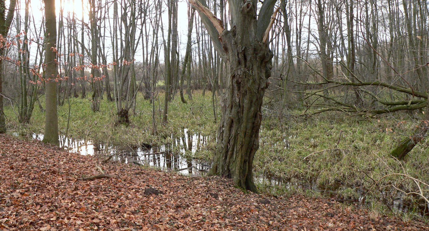
A view of an alluvial forest featuring bare trees, a swampy ground with patches of standing water, and ground covered in fallen brown leaves.
Riparian alluvial forest landscape within the Sundern nature reserve.

Sundern Nature Reserve history and protected-area timeline

Sundern was formally placed under nature protection on 5 April 1931, giving it a protection history that stretches back more than 90 years and places it among the earlier designated nature reserves in what is now the Hannover Region. The underlying motivation for protection was the site's character as a silted-up former loop of the Leine, a river whose glacial valley had long shaped the landscape south of Hannover.

Over the decades, the principal concern for the reserve shifted from outright protection of what remained of the floodplain forest to active management aimed at restoring near-natural conditions. Conservation objectives include converting arable land to extensively managed grassland and rebuilding genuine alluvial forest with a high share of old-growth trees in place of non-native hybrid poplar and conifer stands that had previously been established on the site. Continuous concern has been raised about the slow loss of natural habitat quality in the wetland forest caused by long-term lowering of the groundwater table.

Within the protected area stands the ruin of the Mausoleum of Count Carl von Alten, a memorial built in 1842 for the Hanoverian-British general and statesman Carl von Alten. Designed by the royal Hanoverian court architect Georg Ludwig Friedrich Laves and completed by Conrad Wilhelm Hase, the mausoleum is regarded as the first neo-Gothic brick building in northern Germany. After long falling into ruin, a preservation association was founded in 1987 to save the structure.

Sundern Nature Reserve landscape and geographic character

The landscape of Sundern is defined by its setting within the broad glacial valley of the Leine river (the Leine-Urstromtal), a low-lying corridor of relatively flat terrain south of Hannover. Within this plain, the reserve occupies a former meander that has become detached from the active river channel and slowly filled in with sediment. The result is a slightly elevated, dry mound surrounded by lower, wetter ground, producing a subtle but distinct local relief across an otherwise nearly level landscape.

Surface elevations within the reserve range only from about 55.5 to 63 meters above sea level, reflecting the gentle, lowland character of the site. Parts of the abandoned meander retain the moist, peaty conditions typical of floodplain backwaters, while slightly higher and drier ground within the loop carries mixed deciduous forest. Between these wooded sections, open fields continue to be cultivated, creating a transitional mosaic of woodland, damp depressions, and farmland that visually echoes the historic river-landscape character of the Leine floodplain.

Sundern Nature Reserve ecosystems, habitats, and plant life

Ecologically, Sundern is shaped by the contrast between its wet floodplain soils and drier mineral soils of the old meander ridge. The wetter ground supports floodplain forest types dominated by tree species tolerant of periodic waterlogging, with relict patches of true alluvial forest (Auwald) that have survived in modified form. The slightly drier elevated soils within the meander host mixed deciduous communities, including oak-hornbeam woodland (Carpinion betuli association) and oak-beech mixed forest with a substantial share of old trees, an increasingly rare feature in lowland German landscapes.

These two forest types, the damp alluvial woodland and the drier oak-dominated mixed forest, share the reserve and give it a layered habitat structure. Historically, parts of the wetland forest were replaced by hybrid poplar plantations and conifer stands, which have since become a target for gradual restoration toward more natural floodplain woodland. The agricultural fields between the wooded zones add a further habitat dimension, and management aims to convert at least some of these areas into extensively managed grassland to reduce nutrient inputs and reconnect the woodland mosaic.

Sundern Nature Reserve wildlife and species highlights

The sources emphasize the habitat character of Sundern rather than recording detailed fauna inventories. As a floodplain forest fragment within an agricultural plain, the reserve provides resting, breeding, and feeding habitat for typical lowland forest and wet-woodland birdlife, including species associated with mature deciduous woodland and with damp, shrub-rich forest edges. The presence of old trees and standing deadwood creates nesting opportunities for cavity-nesting species, while the transition between damp woodland and open fields provides edge habitat for generalist farmland-edge fauna.

Wetland-dependent species are supported by the moister parts of the reserve, where the legacy of the original river loop still shapes soil moisture. At the same time, the drier oak-hornbeam and oak-beech stands host woodland species more typical of upland mixed forests. The combination of these habitat types within a small area gives Sundern an ecological richness disproportionate to its size, functioning as a local refuge for native forest wildlife amid a heavily farmed surrounding landscape.

Sundern Nature Reserve conservation status and protection priorities

Sundern's conservation significance rests on its role as one of the older protected natural areas in the Hannover Region and as a surviving example of floodplain forest along the historic Leine corridor. The reserve is classified as an IUCN Category IV area, designated for habitat and species management, meaning that active intervention is part of its conservation mandate rather than passive protection alone.

Key conservation goals include the gradual reestablishment of near-natural alluvial forest with abundant old trees, the removal of non-native and ecologically problematic tree stands such as hybrid poplar and conifer plantations, and the conversion of arable land to extensively managed grassland. A central concern is the gradual loss of natural character in the wetland forest caused by lowering of the groundwater table, which threatens the long-term viability of the moist woodland habitats the reserve was created to protect. The reserve is administered by the Region Hannover with broader oversight from the Lower Saxony State Agency for Water Management, Coastal Protection and Nature Conservation (NLWKN).

Sundern Nature Reserve cultural meaning and human context

The cultural dimension of Sundern is anchored in the mausoleum of Count Carl von Alten, a 19th-century memorial that links the reserve to the broader history of the Kingdom of Hanover and its ties to Britain. Carl von Alten was a Hanoverian-born general who also served the British crown, and the mausoleum was commissioned after his death and completed in 1842 near Wilkenburg, within what is today the protected area.

Designed by the royal Hanoverian court architect Georg Ludwig Friedrich Laves and completed by Conrad Wilhelm Hase, the mausoleum is regarded as the first neo-Gothic brick building in northern Germany, giving the site an early landmark of German neo-Gothic architecture amid a natural setting. After falling into ruin over the decades, the structure became the focus of a preservation association founded in 1987, illustrating how the natural reserve also carries a layer of regional architectural and memorial heritage.

Top sights and standout views in Sundern Nature Reserve

Sundern combines a long protection history, dating back to 1931, with active restoration of near-natural floodplain forest along a silted-up former Leine meander. Its compact mosaic of alluvial woodland remnants and oak-dominated mixed forest with old-growth trees makes it an unusually varied habitat site for its modest 50-hectare size. The reserve also contains the ruin of the Mausoleum of Count Carl von Alten, recognized as the first neo-Gothic brick building in northern Germany, linking natural protection with an early landmark of regional architectural history.

Best time to visit Sundern Nature Reserve

Sundern is best experienced in the milder seasons when the deciduous floodplain forest is in leaf or showing autumn color. Late spring brings fresh green foliage and active birdlife in the canopy and at woodland edges, while autumn highlights the oak-dominated mixed forest stands and the seasonal character of a lowland floodplain woodland. Winters tend to be quiet, with bare trees offering clearer views across the flat glacial valley landscape and toward the mausoleum ruin. Because the reserve is small and lies close to Hannover, visits can be paired easily with broader exploration of the region's protected areas, but accessibility within the reserve may be limited by wet ground and the absence of formal trail infrastructure.

Monthly climate preview

Measured monthly weather trends and precipitation rhythms for Sundern

Sundern Climate Normals and Long Term Temperature Patterns

Long term coordinate records show how mean temperatures and precipitation amounts shift across twelve distinct monthly intervals for Sundern. Reviewing complete annual climate normals provides a structured baseline for understanding regional atmospheric patterns at the representative park elevation.
Annual mean9 °C
0 °C19 °C
Jan
Feb
Mar
Apr
May13°
Jun16°
Jul19°
Aug18°
Sep14°
Oct
Nov
Dec
Warmest month
July

18.5 °C

Coolest month
January

0.4 °C

Wettest month
July

2.5 mm/day

Driest month
April

1.4 mm/day

Park location guide

Geography guide, regional context, and park location map for Sundern Nature Reserve

Sundern Nature Reserve park geography, regions, and map view in Germany

Understand where Sundern Nature Reserve sits in Germany through a broader geographic reading of the surrounding landscape, nearby location context, and its mapped position within the national park landscape.

How Sundern Nature Reserve fits into Germany

Germany is a federal republic in Western and Central Europe with a population of over 83 million across sixteen constituent states. It is Europe's largest economy by nominal GDP and a major global exporter and importer. The capital is Berlin, and the country borders Denmark, Poland, Czech Republic, Austria, Switzerland, France, Luxembourg, Belgium, and the Netherlands.

Wider geography shaping Sundern Nature Reserve in Germany

Germany is located in Western and Central Europe, spanning 357,022 km². It borders Denmark to the north, Poland and the Czech Republic to the east, Austria and Switzerland to the south, and France, Luxembourg, Belgium, and the Netherlands to the west. The country has coastlines on the Baltic Sea and North Sea to the north, with the Alps located in the southern region.

Map view of Sundern Nature Reserve

Use this park location map to pinpoint Sundern Nature Reserve in Germany, understand its exact geographic position, and read its mapped placement within the surrounding landscape more clearly.

Pigeon | © OpenStreetMap contributors

Location context for Sundern Nature Reserve

Region Hannover

Explore detailed imagery of alluvial woodland habitats and glacial valley terrain

Sundern Photos and Landscape Scenery: Visualizing the Protected Leine Floodplain

Visual records capture the distinctive topography, ancient deciduous stands, and wetland depressions that define the protected landscape of Sundern. Examining these field photographs reveals the subtle terrain variations and transitional forest mosaic unique to the former river meander.

A view of an alluvial forest featuring bare trees, a swampy ground with patches of standing water, and ground covered in fallen brown leaves.

Park atlas

Compare connected lowland reserves and floodplain habitats across the surrounding Hannover region

Parks Near Sundern, Exploring Nearby Protected Areas and Regional Landscapes

Browse nearby nature reserves and protected lowland forests situated across the broader Hannover region. Discover adjacent park geography to compare river valley ecosystems and regional conservation networks.
A soft watercolor illustration of a river winding through a green floodplain with rolling hills in the background.
Nature reserveRegion Hannover
About 1.7 km away#1 closest

Southeast

Leineaue zwischen Hannover und Ruthe: Protected Floodplain and River Geography

Nature reserve geography and alluvial habitat mapping.

Examine the topographic and hydrological features of the Leineaue zwischen Hannover und Ruthe nature reserve. This atlas entry provides insights into the site's dual-channel river structure, calcareous tufa springs, and fragmented alluvial woodlands that define this significant conservation area near Hannover.

Area
9.678 km²
Established
2007
Relief
Lowland
Scope
Terrestrial
Watercolor illustration depicting a landscape with soft green hills, forest edges, and distant purple-hued mountains.
Protected areaRegion Hannover
About 6 km away#2 closest

West

Binnensalzstelle am Kaliwerk Ronnenberg: Mapped Protected Area and Industrial Landscape Context

A rare inland saline ecosystem in Region Hannover

Investigate the Binnensalzstelle am Kaliwerk Ronnenberg, a protected area in Region Hannover defined by its unusual saline conditions. This site presents a concentrated intersection of industrial history and ecological rarity, showcasing how potash mine tailings foster salt-dependent habitats in a inland landscape.

Area
0.017 km²
Established
2004
Relief
Lowland
Climate
Temperate
Nature reserveLower Saxony
About 14 km away#3 closest

South

Zigeunerwäldchen Nature Reserve: A Detailed Geographic Atlas of the Haller River Floodplain

Protected riparian forest boundaries in Lower Saxony

Zigeunerwäldchen is a protected nature reserve in Lower Saxony that preserves a vital fragment of the Haller river floodplain. The landscape is defined by willow-dominated alluvial forest, marshy clearings, and thick stands of sedge. By maintaining these natural water-influenced terrains, the reserve provides a rare glimpse into the historical floodplain architecture of the Calenberger Land region.

Area
0.15 km²
Established
1986
A minimalist watercolor painting featuring soft green, yellow, and purple tones depicting a rolling hill landscape with trees and distant hills.
Nature reserveNiedersachsen
About 17 km away#4 closest

Southeast

Haseder Busch, Giesener Berge, Gallberg, Finkenberg Protected Landscape and Map Data

A diverse hill and floodplain ecosystem in Niedersachsen, Germany.

Trace the ecological boundaries and terrain of this expansive nature reserve. The site features a rare convergence of Triassic sedimentary landscapes, including the northernmost calcareous semi-dry grasslands and beech forests in the region, alongside historic floodplain meadows shaped by the Innerste river.

Area
7.42 km²
Established
2019
Nature reserveHildesheim District
About 17 km away#5 closest

East

Wätzumer Tonkuhle Nature Reserve: Geography and Protected Boundaries in Hildesheim District

A restored wetland refuge in the Lower Saxony agricultural landscape

Wätzumer Tonkuhle offers a rare glimpse into secondary wetland succession within the Hildesheim District. This nature reserve features two primary ponds and an extensive fallow corridor along the Alpebach, serving as a critical sanctuary amidst the surrounding intensive farmland of Northern Germany.

Area
0.105 km²
Established
1986
IUCN
IV
Protected areaRegion Hannover
About 19 km away#6 closest

West

Mausohr-Wochenstube bei Barsinghausen: Protected Habitat and Regional Landscape Context

A vital Natura 2000 maternity site in Region Hannover

Examine the geography of Mausohr-Wochenstube bei Barsinghausen, an essential protected area for greater mouse-eared bats. This site showcases the intersection of architectural heritage and natural conservation, relying on the adjacent river corridors and agricultural landscapes of the Region Hannover to sustain its vital ecological function within Lower Saxony.

Area
0.001 km²
Established
2004
Relief
Lowland
Climate
Temperate
Natural monumentRheinland-Pfalz
About 20 km away#7 closest

Southwest

Steinbruch Holzmühle Natural Monument: Protected Limestone Landscapes and Geological Map

Mapping the geological strata and amphibian habitats of the Osterwald hills.

Investigate the geological significance and managed ecological profile of Steinbruch Holzmühle. This site features preserved Kimmeridgian limestone formations and restored habitats that provide a unique case study in post-industrial conservation within the local regional hill network.

A wide panoramic watercolor illustration showing a winding river or stream flowing through a landscape of green pine trees and pink flowering bushes under a pale sky.
Nature reserveRegion Hannover
About 22 km away#8 closest

Northwest

Wadebruch Nature Reserve: Geographic Analysis of a Lower Leine Floodplain Protected Area

A dense mosaic of alder swamps, oxbow channels, and sandy terrace forest in Germany.

Wadebruch serves as a compact, ecologically rich example of a lower Leine floodplain environment. Located in the Hannover Region, this protected site preserves a historic river meander, including an aging oxbow and alder swamp forest, contrasted against steep sandy banks. The site provides essential insights into the natural river patterns that once characterized this part of Lower Saxony.

Area
0.16 km²
Established
1985
IUCN
IV
Relief
Lowland

Common questions about visiting, size, designation, and location context for Sundern Nature Reserve

Sundern Nature Reserve FAQs for park facts, access, geography, and protected area context

Find quick answers about Sundern Nature Reserve, including protected-area facts, park geography, trail and visitor context, and how the park fits into its surrounding country and regional landscape.
MoriAtlas Explorer

Continue Your Protected Areas Search Across the Global Atlas

Deepen your exploration by continuing the structured search for national parks and protected areas worldwide. Utilize the comprehensive filtering capabilities to compare different conservation landscapes and refine your understanding of global park geography. Discover more about the distribution and characteristics of protected natural areas.

Global natural geography