Mori Atlas logo
National parkBouddi National Park

Discover Australia's New South Wales protected national park with unique terrain and marine habitats.

Bouddi National Park: Protected Landscape Map, Rainforests & Coastal Geography

Bouddi National Park in New South Wales offers a distinctive protected landscape where rugged Hawkesbury sandstone terrain meets the Tasman Sea, encompassing rare temperate rainforests within Fletchers Glen and a vibrant marine protected area. This national park provides a unique opportunity to explore mapped coastal formations, including tessellated pavements and laterite plateaus, alongside rich oceanic biodiversity and significant indigenous heritage.

Coastal national parksTemperate rainforestsMarine protected areasNew South Wales parksSandstone landscapesWhale watching locations
Stylized illustration of a coastal landscape featuring rocky cliffs, sandy beach, turquoise water, and green forest under a sunset sky.

Bouddi National Park

National park

Park overview

Structured park overview, official facts, and landscape profile for Bouddi National Park

Bouddi National Park park facts, protected area profile, and essential visitor context
Review the core facts for Bouddi National Park, including designation, size, terrain, visitor scale, habitats, and operating context in one park-focused overview.

About Bouddi National Park

Bouddi National Park occupies a distinctive position as a coastal wilderness area within the Central Coast region of New South Wales, offering a remarkable diversity of habitats within a relatively compact area. The park's landscape transitions from elevated sandstone ridges covered in eucalyptus forest and heath communities down to rocky headlands and beaches that meet the waters of the Tasman Sea. A significant portion of the park's protected area extends beneath the sea surface, creating a fully protected marine zone that encompasses shore, reef, and open water habitats. This marine protection has proven remarkably effective, with documented increases in fish abundance and species diversity compared to adjacent waters. The park's terrestrial environments are equally significant, with the ancient rainforest of Fletchers Glen representing a relic of the wet forest ecosystems that once covered much of this coastal region before clearing for agriculture and development. The combination of coastal, forest, and marine environments within a single protected area makes Bouddi particularly valuable for conservation and provides visitors with an opportunity to experience multiple distinct ecosystems within a day's exploration.

Quick facts and research context for Bouddi National Park

Bouddi National Park spans 1,532 hectares along the Central Coast of New South Wales, situated approximately 93 kilometers northeast of Sydney. The park was originally established as Bouddi Natural Park in 1936 and formally dedicated as a national park in 1967, later receiving its current name in 1974. The park features Hawkesbury sandstone geology with notable tessellated pavements and laterite plateaus along the coastline. Vegetation includes heath communities, eucalyptus forests, and grassy woodland, with the rare Fletchers Glen temperate rainforest representing a significant ecological highlight. The marine extension into the Tasman Sea has contributed to substantially higher fish and species numbers compared to adjacent waters.

Park context

Deeper park guide and search-rich context for Bouddi National Park

Bouddi National Park history, landscape, wildlife, and travel context
Explore Bouddi National Park through its history, landscape character, ecosystems, wildlife, conservation priorities, cultural context, and seasonal travel timing in a structured park guide built for atlas discovery and search intent.

Why Bouddi National Park stands out

Bouddi National Park is best known for its exceptional combination of coastal and rainforest environments in close proximity. Fletchers Glen contains one of the last mature temperate rainforests on the Central Coast, a rare habitat type in this part of New South Wales. The park's marine protected area supports remarkable biodiversity, with surveys showing 70% more fish and 60% more species than nearby unprotected waters. The coastal landscape features dramatic Hawkesbury sandstone formations including tessellated pavements and laterite plateaus, while the marine environment regularly hosts humpback whales, southern right whales, dolphins, and occasional seals.

Ocean view with sandy beach, rocky coastline, forested hills, and waves crashing against shore
Scenic coastal view from Bullimah Outlook in Bouddi National Park

Bouddi National Park history and protected-area timeline

The establishment of Bouddi National Park reflects decades of community advocacy and evolving approaches to protected area management in New South Wales. The reserve was initially created in 1935 as the Bouddi Natural Park, with a trust formed to manage the area with representation from the NSW Federation of Bushwalking Clubs and Erina Shire Council. At the trust's second meeting in July 1936, the name Bouddi was selected from several candidates including Maitland Bay Park, Cape Three Points Reserve, and Gerrinbombi Park. The chosen name reflects the authenticated Aboriginal name for the most prominent natural feature of the district and appears on maps dating to 1828, with Bouddi translating to mean heart. In 1967, the park covering approximately 1,310 acres was formally dedicated as a national park under new state legislation and renamed Bouddi State Park, with management transferred to the NSW National Parks and Wildlife Service. The following year the trust was reconstituted as an advisory committee. On January 1, 1974, legislative changes eliminated the state park category and the area was renamed Bouddi National Park, its current designation.

Bouddi National Park landscape and geographic character

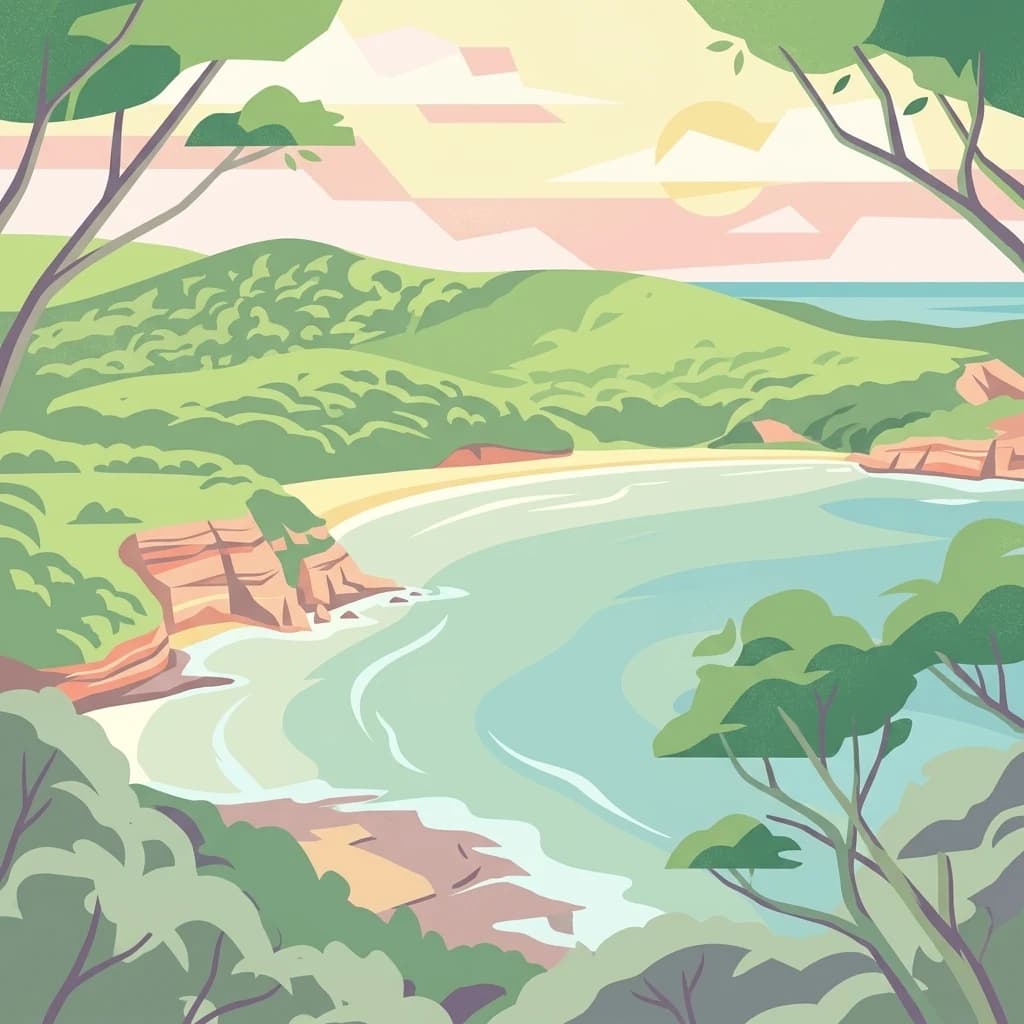
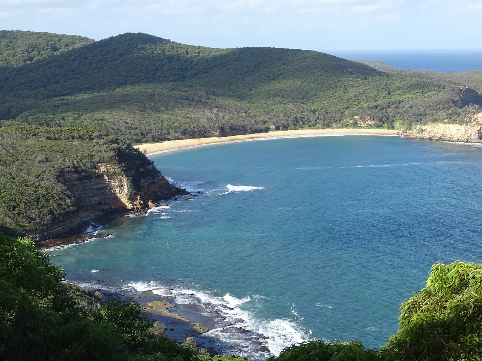
The physical landscape of Bouddi National Park is defined by Hawkesbury sandstone geology, the dominant rock formation of the Sydney region, which creates a distinctive terrain of ridges, cliffs, and rocky platforms. Along the coastal areas, the park contains exceptional examples of tessellated pavements, where erosion has produced a remarkable geometric pattern of angular stone blocks resembling a mosaic floor. Laterite plateaus also occur along the coast, representing weathered iron-rich soil layers that have hardened into resistant caps protecting the underlying sandstone. The park's terrain descends from elevated ridgelines through forest-covered slopes to rocky shoreline and beaches, with the marine portion extending into the Tasman Sea to create a comprehensive protected zone that includes both terrestrial and oceanic habitats.

Bouddi National Park ecosystems, habitats, and plant life

The ecological character of Bouddi National Park encompasses three principal vegetation communities: heath, eucalyptus forest, and grassy woodland, each supporting distinct assemblages of wildlife. The most ecologically significant terrestrial habitat is the temperate rainforest of Fletchers Glen, one of the last remaining mature rainforests on the Central Coast, representing a rare and diminishing ecosystem type in this region. This rainforest contains ancient trees, lush understory, and species adapted to the cool, moist conditions created by the canopy closure. The surrounding eucalyptus forests and heath communities provide additional habitat diversity, supporting different animal species across the park's elevational gradient. The marine environment within the park's protected zone supports exceptional biodiversity, with the fully protected status contributing to significantly higher fish and invertebrate populations than comparable unprotected waters nearby.

Bouddi National Park wildlife and species highlights

Bouddi National Park supports remarkable animal diversity across both terrestrial and marine environments. The terrestrial fauna includes several mammal species such as microbats, greater gliders, and various marsupials that use the forest and woodland habitats. Reptiles are well represented, with species including lace monitors, green tree snakes, and Australian water dragons occurring throughout the park. Over 150 bird species have been documented in the area, reflecting the diversity of habitats from heathland to rainforest canopy. The marine component hosts an impressive array of large mammals, with humpback whales and southern right whales regularly passing through the protected waters, alongside common and bottlenose dolphins. Leopard seals and fur seals are occasionally observed on the coastal rock platforms. Fish surveys have demonstrated the effectiveness of marine protection, showing substantially greater abundance and species richness compared to adjacent waters outside the protected zone.

Bouddi National Park conservation status and protection priorities

Bouddi National Park represents significant conservation value within the Central Coast region through its combination of terrestrial and marine protected habitats. The fully protected marine zone has proven ecologically successful, with research demonstrating dramatic increases in fish populations and species diversity compared to unprotected adjacent waters. The preservation of Fletchers Glen rainforest is particularly important as one of the last remaining mature temperate rainforests in the area, representing a relic of the extensive forest cover that once existed across this coastal region before European settlement and subsequent land clearing. The park protects representative examples of Hawkesbury sandstone landscapes, including rare tessellated pavement formations and laterite plateaus, ensuring these geological features remain intact for scientific study and public appreciation.

Bouddi National Park cultural meaning and human context

The name Bouddi carries deep cultural significance, derived from an indigenous Australian word meaning heart, which was applied to the most conspicuous natural feature of the district. The word appears on maps dating to 1828, demonstrating the longstanding indigenous connection to this landscape and the importance of the area in traditional knowledge systems. The park's establishment in the 1930s followed a period when community organizations, particularly the bushwalking community, recognized the need to protect remaining natural areas from development pressures. The early involvement of the NSW Federation of Bushwalking Clubs and Erina Shire Council in creating the original trust reflects a tradition of community stewardship that continues through contemporary park management.

Top sights and standout views in Bouddi National Park

The distinctive combination of coastal headlands, ancient rainforest, and protected marine waters makes Bouddi a unique conservation area within the Sydney region. The tessellated pavement formations along the coast represent a geological marvel rarely found elsewhere in New South Wales. The marine protected area's documented effectiveness in supporting fish populations and attracting large marine mammals including whales and dolphins demonstrates the value of comprehensive coastal protection. Fletchers Glen rainforest provides visitors with an opportunity to experience an increasingly rare temperate rainforest environment within easy reach of Sydney's metropolitan area.

Best time to visit Bouddi National Park

Bouddi National Park can be visited throughout the year, with each season offering different experiences. Winter and early spring often provide comfortable conditions for bushwalking and wildlife observation, while the cooler months may coincide with whale migration as humpback and southern right whales travel past the coast. Summer visits offer opportunities for beach activities and marine swimming, though the protected marine waters remain a draw in all seasons for snorkeling and diving. The rainforest of Fletchers Glen is particularly appealing in moist conditions when the understory is lush and the environment feels particularly cool and verdant relative to the surrounding dryer landscapes.

Park location guide

Geography guide, regional context, and park location map for Bouddi National Park

Bouddi National Park park geography, regions, and map view in Australia
Understand where Bouddi National Park sits in Australia through a broader geographic reading of the surrounding landscape, nearby location context, and its mapped position within the national park landscape.

How Bouddi National Park fits into Australia

Australia is a constitutional monarchy and federal parliamentary democracy comprising six states and ten territories. With a population of nearly 28 million, it is one of the world's most urbanised countries, with most people concentrated on the eastern seaboard. The country has a high Human Development Index and is known for its cultural diversity, ancient Aboriginal heritage, and unique wildlife.

Wider geography shaping Bouddi National Park in Australia

Australia occupies the entire Australian continent, the island of Tasmania, and numerous smaller islands. It is the world's flattest and driest inhabited continent, featuring vast deserts in the interior (the Outback), tropical rainforests along the eastern coast, and a coastline bordering the Indian and Pacific Oceans.

Map view of Bouddi National Park

Use this park location map to pinpoint Bouddi National Park in Australia, understand its exact geographic position, and read its mapped placement within the surrounding landscape more clearly.

Pigeon | © OpenStreetMap contributors

Location context for Bouddi National Park

New South Wales

Explore the distinctive scenery of New South Wales, from dramatic sandstone coastlines to rare temperate rainforest environments.

Bouddi National Park Photos: Visualizing Coastal Landscapes, Rainforest Habitats, and Marine Views
Explore visual insights into Bouddi National Park's diverse landscapes, showcasing its iconic coastal terrain, rare temperate rainforests, and protected marine environment. These images provide a comprehensive understanding of the park's geological formations, unique habitats, and the distinct natural character of this significant New South Wales protected area.

Ocean view with sandy beach, rocky coastline, forested hills, and waves crashing against shore

Park atlas

Trace the regional spread of coastal protected areas, temperate rainforests, and sandstone landscapes beyond Bouddi National Park.

Discover Nearby National Parks and Protected Areas Beyond Bouddi National Park
Continue your park discovery by exploring other national parks and protected areas geographically connected to Bouddi National Park and its surrounding region. This enables a deeper atlas-style comparison of diverse coastal environments, ancient rainforests, and unique sandstone geology across New South Wales.
National parkNew South Wales

Brisbane Water National Park: A Protected Landscape in New South Wales' Sydney Basin Bioregion

Explore mapped terrain, endangered ecosystems, and coastal waterway geography.

Brisbane Water National Park, located in New South Wales, Australia, is a vital protected area safeguarding critical ecosystems within the Sydney Basin bioregion. This national park features a diverse landscape encompassing rugged escarpments, fertile valleys, and important coastal waterways. Its protected status makes it a crucial conservation refuge, offering insights into unique natural terrain and regional geography for those seeking detailed, map-centric exploration.

Area
115.06 km²
Established
1959
IUCN
II
Relief
Mixed relief
National parkNew South Wales

Wyrrabalong National Park National Park: Protected Littoral Rainforest and Coastal Geography

Explore mapped terrain and vital bird habitats in New South Wales.

Wyrrabalong National Park on New South Wales' Central Coast is an essential protected landscape, noted for safeguarding the last significant coastal littoral rainforest of its kind. This park entry details the mapped geography across its peninsula, island, and beachfront sections, revealing a compact yet ecologically rich environment. It highlights the park's importance as part of an Important Bird Area, supporting significant waterbird and woodland bird populations within its protected boundaries, offering a unique glimpse into a vanishing coastal ecosystem.

Area
6.2 km²
Established
1991
IUCN
II
Relief
Lowland
National parkSydney

Marramarra National Park: Sydney's Protected Landscape and National Park Atlas

Explore mapped boundaries and regional geography near Sydney.

Marramarra National Park stands as a key protected natural landscape near Sydney, Australia. This entry facilitates detailed atlas exploration, focusing on its geographic setting and identity as a national park. Understand the park's mapped borders, its regional context within the Sydney area, and the unique natural landscape it preserves. MoriAtlas provides structured data to comprehend Marramarra National Park's place in the Australian protected areas network and its distinct geographic characteristics.

Area
117.85 km²
Established
1979
IUCN
II
Relief
Upland
National parkNew South Wales

Sydney Harbour National Park: A Distinctive Coastal Protected Landscape in New South Wales

Explore its mapped geography and unique heritage sites.

Sydney Harbour National Park represents an extraordinary protected area in New South Wales, Australia, celebrated for its integration of natural coastal terrain with significant historical sites. This national park offers a unique opportunity for atlas-based exploration of its mapped boundaries, dramatic sandstone headlands, and sheltered harbour locations. Discover the distinctive blend of natural landscape and heritage fortifications that define this metropolitan park, providing a rich geographic context for understanding urban protected areas.

Area
3.92 km²
Established
1975
IUCN
II
Relief
Upland
National parkNew South Wales

Berowra Valley National Park: A National Park in New South Wales with Detailed Geographic Mapping

Explore its mapped boundaries and regional landscape context.

Delve into Berowra Valley National Park, a protected area situated in New South Wales, Australia. This entry provides essential geographic context, focusing on its mapped boundaries and the specific natural landscape it encompasses. It serves as a key resource for understanding the park's role within the broader regional atlas and its distinct protected terrain.

Area
38.84 km²
Established
2012
IUCN
II
Relief
Upland
National parkAustralia

Cattai National Park: Australia's Premier Colonial Heritage Protected Landscape

Mapped riverfront geography and historical Australian park context.

Cattai National Park represents a vital entry in Australia's atlas of protected areas, offering unparalleled insight into the nation's early colonial history alongside its natural riverine landscapes. The park's designation as a national park highlights its importance in preserving not only the unique geography of the Hawkesbury River floodplain but also significant historical sites like the Hope Farm Mill, Australia's oldest industrial site. Exploring Cattai National Park allows for a deep dive into mapped protected boundaries and the layered cultural and natural terrain of the Sydney region.

Area
4.24 km²
Established
1992
IUCN
II
Access
Easy access
National parkAustralia

Scheyville National Park: An Australian National Park's Mapped Protected Landscape and Regional Geography

Explore the protected boundaries and natural terrain of this park.

Scheyville National Park represents a vital protected area within Australia, offering a unique lens for geographic exploration. As a national park, its boundaries and landscape characteristics are essential for understanding its place in the regional geography. This content facilitates structured discovery of its natural terrain and mapped extent, providing foundational context for atlas-based learning about Australia's protected lands.

Area
9.2 km²
Established
1996
IUCN
V
Relief
Upland
National parkNew South Wales

Watagans National Park: National Park Protected Landscape in New South Wales

Explore its mapped boundaries and regional geography.

Watagans National Park stands as a key protected area within New South Wales, Australia. This detail page focuses on its specific role as a national park, offering insights into its mapped geographic boundaries and its place within the regional landscape. Understand the protected natural identity of Watagans National Park through a structured, atlas-informed lens.

Area
77.51 km²
Established
1999
IUCN
II
Climate
Temperate

Common questions about visiting, size, designation, and location context for Bouddi National Park

Bouddi National Park FAQs for park facts, access, geography, and protected area context
Find quick answers about Bouddi National Park, including protected-area facts, park geography, trail and visitor context, and how the park fits into its surrounding country and regional landscape.
MoriAtlas Explorer

Continue Your Protected Areas Search Across the Global Atlas

Deepen your exploration by continuing the structured search for national parks and protected areas worldwide. Utilize the comprehensive filtering capabilities to compare different conservation landscapes and refine your understanding of global park geography. Discover more about the distribution and characteristics of protected natural areas.

Global natural geography