

Mori Atlas logo
Protected areaCape Blanche Conservation Park

Ecological mapping of shoreline habitats, raptor nesting grounds, and limestone terrain

Cape Blanche Conservation Park: A Protected Coastal Landscape on the Western Eyre Peninsula

Cape Blanche Conservation Park represents a significant protected coastal stretch along the western Eyre Peninsula in South Australia. This reserve secures essential nesting habitats for eastern osprey and white-bellied sea-eagle populations while preserving fragile shoreline ecosystems. The landscape is defined by its exposed limestone cliffs, wind-swept dunes, and coastal scrub that serve as a refuge for threatened and migratory shorebirds.

coastal reserveeyre peninsulasouth australiaraptor breeding habitatshorebird habitatmigratory birds

Cape Blanche Conservation Park

Protected area

Park overview

Structured park overview, official facts, and landscape profile for Cape Blanche Conservation Park

Cape Blanche Conservation Park park facts, protected area profile, and essential visitor context

Review the core facts for Cape Blanche Conservation Park, including designation, size, terrain, visitor scale, habitats, and operating context in one park-focused overview.

About Cape Blanche Conservation Park

Cape Blanche Conservation Park is a state-level conservation reserve on the western coast of the Eyre Peninsula in South Australia. It occupies a stretch of comparatively remote coastline south of the small coastal town of Streaky Bay, an area characterised by low population density, pastoral land use, and long, uninterrupted shorelines that face the Southern Ocean. The park was proclaimed in February 2012, making it a relatively recent addition to South Australia's network of protected areas and reflecting modern conservation priorities rather than older 20th-century reserve design.

The reserve covers a substantial area of coastal land, including the headland from which it takes its name and the surrounding littoral environments. Its physical character is defined by the interface between land and sea: cliffed and rocky shores, sandy beaches, dunes, exposed limestone or calcarenite formations typical of the western Eyre Peninsula, and patches of coastal scrub and heath that thrive in the wind-swept, salt-influenced conditions along this part of the South Australian coast.

What distinguishes Cape Blanche from many other South Australian coastal reserves is the specific purpose for which it was gazetted. Rather than being a general-purpose national park focused on broad scenic or wilderness values, Cape Blanche was created with clearly articulated, ecologically driven objectives. These include the protection of breeding habitat for large fish-eating raptors, the conservation of a diverse range of coastal flora including regionally significant species such as the West Coast mintbush, and the safeguarding of habitat for shorebirds of conservation concern.

Framing the reserve as an IUCN Category III natural monument or feature underscores that its significance lies in specific natural values rather than in large-scale landscape representation. The park's role within the broader Eyre Peninsula conservation context is complementary: it adds targeted protection for raptor nesting habitat, specialised coastal plants, and beach-nesting or migratory shorebirds in a section of coastline that remains lightly settled and relatively undisturbed.

Quick facts and research context for Cape Blanche Conservation Park

Cape Blanche Conservation Park lies on the west coast of the Eyre Peninsula in South Australia, in the broad region between Streaky Bay and the more southerly stretches of the peninsula's western shoreline. It is a state conservation park proclaimed on 9 February 2012 under the National Parks and Wildlife Act 1972, and it is managed by the South Australian Department for Environment and Water.

The park was created with explicit objectives, including the protection of breeding habitat for the eastern osprey and the white-bellied sea-eagle, the conservation of diverse coastal flora such as the West Coast mintbush, and the safeguarding of habitat for threatened and migratory shorebirds including the hooded plover, sooty oystercatcher, and sanderling. Internationally, the reserve is classified as an IUCN Category III protected area, recognising it as a natural feature or monument of conservation significance.

Protection and recognition

Review documented protected area records and international recognition data.

Cape Blanche Conservation Park Protection Status and Designated Terrestrial Scope

Terrestrial protection records outline the formal administrative scope and conservation status established for Cape Blanche Conservation Park. Verified management data provides essential context for tracking protected area designations and geographic governance.

Protection details

Protection scope
Terrestrial
Transboundary protection
No
Park context

Deeper park guide and search-rich context for Cape Blanche Conservation Park

Cape Blanche Conservation Park history, landscape, wildlife, and travel context

Explore Cape Blanche Conservation Park through its history, landscape character, ecosystems, wildlife, conservation priorities, cultural context, and seasonal travel timing in a structured park guide built for atlas discovery and search intent.

Why Cape Blanche Conservation Park stands out

Cape Blanche Conservation Park is best known for its role as a stronghold of breeding habitat for two large coastal raptors, the eastern osprey and the white-bellied sea-eagle. These fish-eating birds rely on undisturbed cliffs, headlands, and shoreline trees along the Eyre Peninsula's western coast, and the park was gazetted specifically to secure a representative stretch of such habitat within the South Australian reserve system. Beyond its raptor significance, the reserve is also valued for the persistence of specialised coastal flora, including the West Coast mintbush, and for the integrity of shoreline environments that continue to support threatened and migratory shorebirds such as the hooded plover, sooty oystercatcher, and sanderling. Together, these qualities define the park as a coastal, species-focused conservation reserve rather than a landscape-scale wilderness park.

Cape Blanche Conservation Park history and protected-area timeline

Cape Blanche Conservation Park is a relatively young protected area in the South Australian reserve system. It was proclaimed on 9 February 2012 under the National Parks and Wildlife Act 1972, the principal legislation governing the establishment and management of protected areas in South Australia.

The park's establishment was driven by conservation concerns specific to the western Eyre Peninsula. Proclamation documents of the time articulated explicit objectives: the protection of important breeding habitat for the eastern osprey and the white-bellied sea-eagle, the conservation of a diverse range of flora including the West Coast mintbush, and the safeguarding of habitat for threatened and migratory shorebirds such as the hooded plover, sooty oystercatcher, and sanderling.

Its inclusion in the international IUCN framework as a Category III protected area signals that, from inception, the reserve was conceived as a site of specific natural feature value rather than as a broad multipurpose landscape park. Management responsibility has rested with the South Australian Department for Environment and Water, the state agency responsible for biodiversity and protected-area stewardship.

Cape Blanche Conservation Park landscape and geographic character

Cape Blanche Conservation Park occupies a section of the western Eyre Peninsula coastline, a region shaped by long exposure to Southern Ocean weather systems and by the calcarenite and limestone geology that characterises much of this part of South Australia. The result is a coastline of alternating cliffed headlands, low rocky shores, sandy bays, and dune-backed beaches, often interspersed with flats of coastal scrub.

The terrain is generally low-lying in elevation terms, but visually expressive through its continuous interplay of landform and sea. Exposed rock platforms, weathered limestone outcrops, and wind-shaped coastal vegetation give the shoreline a rugged, undisturbed character. Inland of the immediate coast, the landscape transitions into more typical Eyre Peninsula vegetation patterns, including chenopod shrublands, low heath, and scattered patches of taller coastal scrub that provide structural diversity.

The cape itself, from which the park takes its name, forms a prominent coastal promontory within this otherwise long, linear stretch of shoreline. The surrounding seascape is open and wave-exposed, with no significant sheltering landforms between the park's coast and the open ocean, which contributes to the persistent maritime influence on the park's climate, vegetation, and wildlife.

Cape Blanche Conservation Park ecosystems, habitats, and plant life

The ecological identity of Cape Blanche Conservation Park is fundamentally coastal. Its habitats fall within the broader suite of Eyre Peninsula littoral environments, including cliff and headland vegetation, dune systems, samphire and succulent flats on saline or seasonally wet substrates, and patches of woody coastal scrub. These habitats support a flora that has evolved under salt spray, wind exposure, and nutrient-limited calcareous soils.

The park was specifically gazetted to protect a diverse range of flora, and the West Coast mintbush, Prostanthera calycina, is highlighted as a particular conservation focus. This species exemplifies the kind of regionally restricted coastal plant for which the western Eyre Peninsula is notable, and its presence reinforces the botanical significance of the habitats contained within the reserve.

Marine-adjacent habitats also play a key ecological role. Supratidal and intertidal zones provide feeding areas for shorebirds, while near-shore waters are used by fish-eating birds. The combination of undisturbed shoreline structure, varied coastal vegetation, and intact inshore marine conditions defines the reserve's ecological character.

Cape Blanche Conservation Park wildlife and species highlights

Wildlife is the central feature of Cape Blanche Conservation Park, and the species flagged at its proclamation remain the park's most prominent faunal attributes. The eastern osprey and the white-bellied sea-eagle, both large fish-eating raptors, are the species for whose breeding habitat the park was specifically protected. Both nest along the Eyre Peninsula coast, often utilising cliff ledges, headland trees, or elevated structures, and the park's protected status helps secure a continuity of undisturbed breeding sites.

Shorebird diversity is another key element of the reserve's wildlife profile. Hooded plover, a species of conservation concern in southern Australia due to its reliance on undisturbed ocean beaches for nesting, is among the threatened shorebirds highlighted in the proclamation. The sooty oystercatcher, a rocky-shore specialist, and the sanderling, a small migratory shorebird that uses broad sandy beaches, are similarly listed. Their inclusion underscores the importance of the park's beaches, rocky platforms, and tidal flats as functional habitat.

Beyond these flagged species, the park's mosaic of coastal habitats can be expected to support typical western Eyre Peninsula fauna, including small reptiles adapted to coastal heath, occasional land-based mammals, and a wider community of seabirds and migratory waders that use the South Australian coast as part of broader flyways.

Cape Blanche Conservation Park conservation status and protection priorities

Cape Blanche Conservation Park is a tightly purpose-built conservation reserve. Its proclamation under the National Parks and Wildlife Act 1972 is unusual in the precision of its stated objectives: rather than a general mandate to protect natural or scenic values, the park was specifically created to secure breeding habitat for two raptor species, conserve a defined suite of coastal flora, and protect habitat for threatened and migratory shorebirds.

This species-and-habitat focus aligns the park closely with modern conservation planning practice, where individual reserves are designed to fill identified gaps in habitat protection for particular taxa. The inclusion of a regionally significant plant species such as the West Coast mintbush reflects the recognition that the western Eyre Peninsula supports narrowly distributed coastal flora requiring explicit protection.

The park's international classification as an IUCN Category III protected area (natural monument or feature) further reinforces its conservation framing. This category is applied to areas containing specific natural features of outstanding or distinctive value, which in Cape Blanche's case corresponds to the combination of raptor breeding habitat, specialised coastal flora, and shorebird refuge along a relatively undisturbed stretch of South Australian coastline. Management by the Department for Environment and Water ensures that the reserve sits within the institutional framework of South Australian biodiversity policy.

Top sights and standout views in Cape Blanche Conservation Park

The defining highlights of Cape Blanche Conservation Park are concentrated along its coastline. The park contains breeding habitat for eastern osprey and white-bellied sea-eagle, two of the most conspicuous and ecologically significant raptor species of the southern Australian coast. The shoreline also retains habitat for threatened and migratory shorebirds, including the hooded plover, sooty oystercatcher, and sanderling, making the reserve a year-round and seasonal refuge of considerable conservation value.

Botanically, the park is notable for supporting a diverse range of coastal flora, with the West Coast mintbush standing out as a regionally significant species whose protection was highlighted at the time of proclamation. Combined with the relatively undisturbed condition of the park's cliffs, dunes, scrub, and inshore waters, these features make Cape Blanche a compact but ecologically rich addition to the Eyre Peninsula's protected-area network.

Best time to visit Cape Blanche Conservation Park

Cape Blanche Conservation Park's coastal setting means that visitation is shaped primarily by the maritime climate of the western Eyre Peninsula, which is characterised by mild, often windy conditions and relatively low rainfall. Spring and early summer typically bring more stable weather, active shorebird and raptor presence along the coastline, and flowering periods for many coastal plants, offering the most rewarding conditions for observing the park's ecological values.

Autumn can also provide good conditions, with cooler temperatures, continuing shorebird activity, and reduced summer wind intensity. Winter brings cooler temperatures and stronger frontal weather, but also a peak season for many migratory shorebirds returning to or passing along the southern Australian coast, which can be a meaningful period for shorebird observation. Visitors should generally expect that conditions along this exposed coastline can change quickly, and that the park's appeal lies in quiet natural observation rather than in developed visitor infrastructure.
Monthly climate preview

Long-term representative temperature ranges and precipitation patterns across the year

Cape Blanche Conservation Park Climate Normals and Monthly Weather Records

Measured coordinates for Cape Blanche Conservation Park show annual temperature variations alongside monthly precipitation averages from long-term NASA data. Reviewing the complete twelve-month profile provides deeper context for examining regional climate behavior across the protected area.
Annual mean17 °C
13 °C22 °C
Jan22°
Feb22°
Mar20°
Apr18°
May16°
Jun14°
Jul13°
Aug13°
Sep15°
Oct17°
Nov19°
Dec20°
Warmest month
February

21.9 °C

Coolest month
July

12.7 °C

Wettest month
July

1.5 mm/day

Driest month
January

0.4 mm/day

Park location guide

Geography guide, regional context, and park location map for Cape Blanche Conservation Park

Cape Blanche Conservation Park park geography, regions, and map view in Australia

Understand where Cape Blanche Conservation Park sits in Australia through a broader geographic reading of the surrounding landscape, nearby location context, and its mapped position within the national park landscape.

How Cape Blanche Conservation Park fits into Australia

Australia is a constitutional monarchy and federal parliamentary democracy comprising six states and ten territories. With a population of nearly 28 million, it is one of the world's most urbanised countries, with most people concentrated on the eastern seaboard. The country has a high Human Development Index and is known for its cultural diversity, ancient Aboriginal heritage, and unique wildlife.

Wider geography shaping Cape Blanche Conservation Park in Australia

Australia occupies the entire Australian continent, the island of Tasmania, and numerous smaller islands. It is the world's flattest and driest inhabited continent, featuring vast deserts in the interior (the Outback), tropical rainforests along the eastern coast, and a coastline bordering the Indian and Pacific Oceans.

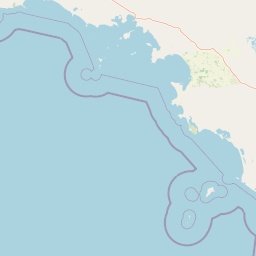
Map view of Cape Blanche Conservation Park

Use this park location map to pinpoint Cape Blanche Conservation Park in Australia, understand its exact geographic position, and read its mapped placement within the surrounding landscape more clearly.

Pigeon | © OpenStreetMap contributors

Location context for Cape Blanche Conservation Park

Eyre PeninsulaSouth Australia
Natural feature types

Navigate the Natural Features of Cape Blanche Conservation Park

Access the comprehensive MoriAtlas collection to browse the specific landforms and shoreline environments that define Cape Blanche Conservation Park. Utilize this atlas to understand the complex geographic relationships between the peninsula's limestone geology and the protected habitats found throughout the coastal zone.
Park atlas

Compare regional protected areas and connected coastal landscapes across South Australia.

Explore Other Parks Near Cape Blanche Conservation Park and Surrounding Coastal Reserves

Continue browsing adjacent protected areas and shoreline reserves located throughout the wider Eyre Peninsula region. Comparing these nearby coastal habitats provides broader regional context for South Australian conservation landscapes.
Nature reserveSouth Australia
About 15 km away#1 closest

East

Calpatanna Waterhole Conservation Park: Protected Geography and Coastal Reserve Mapping

Nature reserve landscape within the South Australian Eyre Peninsula

Calpatanna Waterhole Conservation Park represents a specialized protected environment within South Australia. Centred on its namesake waterhole, the area preserves a distinctive mosaic of seasonal saline lagoons and hardy mallee eucalyptus scrub. This reserve highlights the ecological and geographic character of the Eyre Peninsula, where low undulating terrain supports unique, salt-adapted vegetation communities.

Area
36.44 km²
Established
1974
IUCN
Ia
Relief
Lowland
Nature reserveSouth Australia
38 km away#2 closest

North

Eba Island Conservation Park: Coastal Landforms and Nature Reserve Geography in South Australia

A protected offshore sanctuary within Streaky Bay's coastal landscape.

Eba Island Conservation Park represents a key protected area within the coastal geography of South Australia. Composed primarily of calcarenite and limestone, the reserve features a diverse range of coastal landforms, including rugged jagged ridges, active blowholes, and sheltered coves, providing an essential habitat for seabird colonies.

Area
1.34 km²
Established
1966
IUCN
Ia
Relief
Lowland
Wildlife reserveSouth Australia
89 km away#3 closest

Northeast

Gawler Ranges Conservation Park: Mallee Landscapes and Regional Protected Areas

Semi-arid habitat and rocky terrain of South Australia

Gawler Ranges Conservation Park protects a core area of tree mallee woodland and rocky rises near the southern fringe of the Gawler Ranges. This wildlife reserve serves as an essential anchor for regional biodiversity on the Eyre Peninsula, offering a look at the arid-adapted vegetation and weathered geological structures that define this remote section of South Australia.

Area
154.8 km²
Established
1993
IUCN
VI
Relief
Upland
Wildlife reserveSouth Australia
About 102 km away#4 closest

East

Cocata Conservation Park: Eyre Peninsula Protected Wildlife Reserve and Landscape Map

Geographic overview of South Australian conservation lands.

Cocata Conservation Park encompasses a vast semi-arid expanse on the Eyre Peninsula, characterized by gently undulating plains, calcrete-capped terrain, and open salt flats. Gain insights into the physical geography and habitat distribution of this important South Australian wildlife reserve through detailed regional mapping.

Area
167.62 km²
Established
1993
IUCN
VI
Scope
Terrestrial
National parkSouth Australia
105 km away#5 closest

Northeast

Gawler Ranges National Park: South Australia's Mapped Protected National Landscape

Explore the geography and protected area context of this national park.

Gawler Ranges National Park stands as a significant protected area within the geographic expanse of South Australia. Designated as a national park, it offers valuable insights into Australia's conservation landscapes and regional geography. Users can explore its mapped boundaries and understand its unique role within the national park system, making it a key point for structured geographic study and atlas-based discovery of protected lands.

Area
1,628.75 km²
Established
2002
IUCN
VI
Relief
Mountain
Wildlife reserveSouth Australia
About 114 km away#6 closest

East

Dakalanta Sanctuary: A Private Wildlife Reserve on the Northern Eyre Peninsula

Mapped regional geography and conservation habitat profiles

Dakalanta Sanctuary provides a significant example of private land conservation in South Australia. Covering 130 square kilometres of low hills and stabilized dunes, this reserve focuses on restoring native vegetation after past pastoral use. The area is vital for safeguarding semi-arid habitats like mallee woodlands, playing an active role in regional biodiversity protection and habitat connectivity.

Area
130 km²
Established
2002
Relief
Upland
Access
Access unknown
Marine protected areaSouth Australia
About 131 km away#7 closest

South

Western Eyre Marine Park: Geography and Marine Protected Area Atlas of South Australia

Explore offshore continental shelf zones and vast ocean boundaries

Western Eyre Marine Park represents a major commitment to marine conservation in the Great Australian Bight. This detailed atlas entry outlines the park's expansive management zones and its role within the broader South-West Marine Park Network. Observe the offshore terrain of the southern Australian continental shelf and the structural importance of this remote, cool-water oceanic reserve.

Area
57,946 km²
Established
2012
Relief
Lowland
Climate
Temperate
Nature reserveSouth Australia
About 132 km away#8 closest

Southeast

Cap Island Conservation Park: Nature Reserve and Offshore Marine Habitat in South Australia

Coastal granite island and protected seabird breeding landscape.

Situated off the coast of the Eyre Peninsula, Cap Island Conservation Park is a protected nature reserve serving as a critical sanctuary for pinnipeds and nesting seabirds. Its unique geological profile, featuring a granite base and calcarenite cap, creates a rugged offshore environment shaped by marine erosion and salt-tolerant vegetation. The reserve highlights the significance of isolated island ecosystems within the broader geography of South Australia.

Area
0.09 km²
Established
1967
IUCN
Ia
Relief
Lowland

Common questions about visiting, size, designation, and location context for Cape Blanche Conservation Park

Cape Blanche Conservation Park FAQs for park facts, access, geography, and protected area context

Find quick answers about Cape Blanche Conservation Park, including protected-area facts, park geography, trail and visitor context, and how the park fits into its surrounding country and regional landscape.
MoriAtlas Explorer

Continue Your Protected Areas Search Across the Global Atlas

Deepen your exploration by continuing the structured search for national parks and protected areas worldwide. Utilize the comprehensive filtering capabilities to compare different conservation landscapes and refine your understanding of global park geography. Discover more about the distribution and characteristics of protected natural areas.

Global natural geography