

Mori Atlas logo
Wildlife reserveGawler Ranges Conservation Park

Mapping the semi-arid mallee woodlands and rocky terrain of the Eyre Peninsula

Gawler Ranges Conservation Park: A Protected Wildlife Reserve in South Australia

Gawler Ranges Conservation Park preserves a significant expanse of tree mallee habitat on the Eyre Peninsula in South Australia. This protected area showcases a distinct semi-arid landscape characterized by rocky ridges, shallow valleys, and dense woodland corridors of red mallee and yorrell. As an important component of the regional conservation network, the terrain reflects the ancient geological history of the Gawler Craton, providing a window into the natural environment of the western Eyre Peninsula.

mallee woodlandEyre Peninsulasemi-arid landscapeconservation parkSouth Australiatree mallee

Gawler Ranges Conservation Park

Wildlife reserve

Park overview

Structured park overview, official facts, and landscape profile for Gawler Ranges Conservation Park

Gawler Ranges Conservation Park park facts, protected area profile, and essential visitor context

Review the core facts for Gawler Ranges Conservation Park, including designation, size, terrain, visitor scale, habitats, and operating context in one park-focused overview.

About Gawler Ranges Conservation Park

Gawler Ranges Conservation Park occupies a stretch of semi-arid country on the western Eyre Peninsula, positioned to the south-west of the broader Gawler Ranges land system. Although modest in size, the protected area carries real ecological significance because it preserves a representative sample of the mallee-dominated landscapes that once extended across much of this part of South Australia, before large areas were cleared for agriculture and grazing.

The park sits within remote and lightly settled pastoral country, with the closest community of any size being Poochera, a small town on the Eyre Peninsula roughly 28 kilometres to the south-east. The conservation area straddles the gazetted locality of Bockelberg, with a smaller southern section falling within Minnipa. Its position relative to the Gawler Ranges, including the larger Gawler Ranges National Park further to the north-east, gives it an important complementary role in the region's broader network of reserves.

Vegetation across the park is dominated by multi-stemmed tree mallee eucalypts, low in stature but dense in cover, that are well adapted to the region's dry climate and rocky soils. The understorey, the substrate, and the rolling rocky relief together produce a landscape that feels distinctly Australian in character: open, sun-bleached, and shaped by long periods of heat and limited rainfall. Together, these qualities make the conservation park a focused refuge for mallee ecology rather than a destination of dramatic scenery, and they explain why the South Australian government has formally protected it as part of the state's conservation estate.

Quick facts and research context for Gawler Ranges Conservation Park

Gawler Ranges Conservation Park is an IUCN Category VI protected area managed by South Australia's Department for Environment and Water. It occupies approximately 155 square kilometres of semi-arid country on the Eyre Peninsula and was gazetted in 1993 under the state's Crown Lands Act before being redesignated as a conservation park in 2012.

Protection and recognition

Documented terrestrial protection scope and historical designation data

Gawler Ranges Conservation Park Protection Status and Designation History

Gawler Ranges Conservation Park maintains a documented terrestrial protection status established in two thousand twelve. Structured facts outline the official designation history and management scope without imported international recognition sources.

Protection details

Protection scope
Terrestrial
Designated year
2012
Transboundary protection
No
Park context

Deeper park guide and search-rich context for Gawler Ranges Conservation Park

Gawler Ranges Conservation Park history, landscape, wildlife, and travel context

Explore Gawler Ranges Conservation Park through its history, landscape character, ecosystems, wildlife, conservation priorities, cultural context, and seasonal travel timing in a structured park guide built for atlas discovery and search intent.

Why Gawler Ranges Conservation Park stands out

The conservation park is best known for its extensive stands of tree mallee woodland, particularly red mallee, gilja, and scattered yorrell, set against the rocky terrain at the southern fringe of the Gawler Ranges. It represents one of the more accessible examples of Eyre Peninsula mallee habitat preserved under formal conservation protection.

Gawler Ranges Conservation Park history and protected-area timeline

The protected area that is today known as Gawler Ranges Conservation Park went through a notably tangled administrative history before arriving at its current form. The Geographical Names Board originally approved the name Bockelberg Conservation Park for the site, reflecting its location within the Bockelberg locality. Due to legal processes, however, the area was not constituted under the National Parks and Wildlife Act 1972 as originally intended.

Instead, on 11 November 1993, it was declared under the state's Crown Lands Act 1929 as the Gawler Ranges Conservation Reserve, with its name chosen because of its proximity to the better-known Gawler Ranges. By 2006, it was the stated intention that this conservation reserve would be incorporated into the adjoining Gawler Ranges National Park, signalling that the reserve was always regarded as part of a larger conservation picture for the region.

The reserve was eventually redesignated as Gawler Ranges Conservation Park on 6 September 2012, bringing it formally under the national parks and wildlife framework as a conservation park. Today it is managed by the South Australian Department for Environment and Water and recognised as an IUCN Category VI protected area, sealing its place within the state's modern system of conservation reserves.

Gawler Ranges Conservation Park landscape and geographic character

The landscape of Gawler Ranges Conservation Park is shaped by the semi-arid character of the western Eyre Peninsula and by its position at the southern fringe of the Gawler Ranges volcanic province. The terrain tends to be gently undulating, with rocky rises, shallow valleys, and exposures of harder basement rock typical of the older Gawler Craton country that underlies much of this part of South Australia.

Soils are generally shallow and infertile by agricultural standards, and the climate is hot and dry, with low and unreliable rainfall that supports hardy, drought-adapted vegetation rather than dense forest. The visual impression is one of wide horizons, low tree cover, and a colour palette dominated by the muted greens, greys, and ochres of mallee leaves, weathered rock, and dusty ground.

Rather than presenting dramatic peaks or deeply carved gorges, the conservation park offers a quiet, textured landscape: rocky ridges broken by corridors of mallee, open swales between the rises, and a horizon line that always carries the sense of being on the edge of a much larger, sparsely settled country.

Gawler Ranges Conservation Park ecosystems, habitats, and plant life

Ecologically, Gawler Ranges Conservation Park sits firmly within the mallee zone of southern Australia. Although small in absolute size, it preserves a coherent example of mallee woodland on Eyre Peninsula soils and geology, and so it has outsize importance for representing this habitat type within the regional conservation network.

The vegetation is dominated by tree mallee eucalypts, low-growing trees that characteristically form multiple slender stems from a swollen lignotuber near the ground. The most extensively recorded species in this mix are red mallee, gilja, and yorrell, with scattered patches of yorrell providing variation across the otherwise broad stands of red mallee and gilja. The result is a vegetation mosaic that, while broadly uniform at a glance, contains subtle differences in species composition and density across the park.

Because the surrounding Eyre Peninsula has seen significant land-clearing for cropping and grazing, the conservation value of the park rests substantially on its preservation of relatively intact mallee habitat with its full complement of soil crusts, leaf litter, and associated understorey plants. The protected area thus contributes to the long-term conservation of mallee ecosystem processes on a peninsula where such unbroken examples are increasingly rare.

Gawler Ranges Conservation Park wildlife and species highlights

Detailed species-level information about Gawler Ranges Conservation Park is limited in the available sources, and the park's wildlife profile is best understood as a function of its mallee habitat rather than as a list of individually documented species. As with other semi-arid mallee reserves on the Eyre Peninsula, it provides cover and forage for typical inhabitants of this vegetation type, including a range of small ground-dwelling mammals, reptiles, and birds adapted to dry conditions and dense low woodland.

Its position adjacent to much larger tracts of natural habitat, including the Gawler Ranges National Park, also gives the conservation park a role as part of a broader landscape through which wildlife can move between protected areas. Because the source material does not provide reliable species accounts, any stronger statements about named species or population figures should be avoided.

Gawler Ranges Conservation Park conservation status and protection priorities

Conservation significance for Gawler Ranges Conservation Park lies less in spectacular or iconic species and more in the preservation of a representative block of Eyre Peninsula mallee habitat at a time when much of the surrounding countryside has been converted to farmland. By securing a sizeable tract of intact mallee vegetation under formal protection, the park helps maintain habitat continuity and ecological processes that would otherwise be reduced to fragments on this part of the peninsula.

Its IUCN Category VI status reflects a conservation designation that allows for sustainable use of natural resources alongside protection of ecosystems, aligning it with a model of conservation that retains the landscape's working pastoral character rather than locking it away entirely. The formal redesignation of the area from conservation reserve to conservation park in 2012 also represents an administrative strengthening of its protection, drawing it more fully into the South Australian national parks and wildlife framework.

Together, these factors make the conservation park a meaningful contributor to habitat protection on the Eyre Peninsula, even though it occupies a relatively small share of the regional land area.

Top sights and standout views in Gawler Ranges Conservation Park

The conservation park stands out for the unbroken character of its mallee woodland, the contrast between its rocky rises and softer swales, and its quiet, semi-arid atmosphere typical of the far west of the Eyre Peninsula. Its redesignation in 2012 marked a clearer place for it within the state's conservation system, complementing the nearby Gawler Ranges National Park and reinforcing the protection of habitat in a region long shaped by pastoral use.

Best time to visit Gawler Ranges Conservation Park

Seasonal conditions on the Eyre Peninsula are strongly shaped by a hot, dry climate with cool, sometimes wetter winters. Cooler months generally offer more comfortable conditions for exploring mallee country, when temperatures are lower and, in good seasons, the vegetation and soils respond to winter rainfall. By contrast, the warmer months are typically hot and dry, which can make outdoor exploration less pleasant but produces the classic bleached, sunlit appearance of mallee in late summer and autumn. Visitors should plan around personal tolerance for heat and remoteness rather than around any single dramatic seasonal event.
Monthly climate preview

Long term monthly temperature and precipitation averages for South Australia

Gawler Ranges Conservation Park Climate Normals and Temperature Rhythms

Gawler Ranges Conservation Park displays measured long term temperature variations alongside consistent low precipitation patterns across the representative coordinate. Analyzing the complete monthly climate profile provides detailed historical temperature ranges and precipitation averages for ongoing geographical research.
Annual mean18 °C
11 °C25 °C
Jan25°
Feb25°
Mar22°
Apr19°
May15°
Jun12°
Jul11°
Aug12°
Sep15°
Oct18°
Nov21°
Dec23°
Warmest month
January

25.5 °C

Coolest month
July

11 °C

Wettest month
June

1.1 mm/day

Driest month
January

0.4 mm/day

Park location guide

Geography guide, regional context, and park location map for Gawler Ranges Conservation Park

Gawler Ranges Conservation Park park geography, regions, and map view in Australia

Understand where Gawler Ranges Conservation Park sits in Australia through a broader geographic reading of the surrounding landscape, nearby location context, and its mapped position within the national park landscape.

How Gawler Ranges Conservation Park fits into Australia

Australia is a constitutional monarchy and federal parliamentary democracy comprising six states and ten territories. With a population of nearly 28 million, it is one of the world's most urbanised countries, with most people concentrated on the eastern seaboard. The country has a high Human Development Index and is known for its cultural diversity, ancient Aboriginal heritage, and unique wildlife.

Wider geography shaping Gawler Ranges Conservation Park in Australia

Australia occupies the entire Australian continent, the island of Tasmania, and numerous smaller islands. It is the world's flattest and driest inhabited continent, featuring vast deserts in the interior (the Outback), tropical rainforests along the eastern coast, and a coastline bordering the Indian and Pacific Oceans.

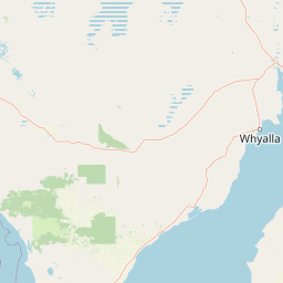
Map view of Gawler Ranges Conservation Park

Use this park location map to pinpoint Gawler Ranges Conservation Park in Australia, understand its exact geographic position, and read its mapped placement within the surrounding landscape more clearly.

Pigeon | © OpenStreetMap contributors

Location context for Gawler Ranges Conservation Park

South Australia
Park atlas

Compare regional mallee reserves and connected wilderness areas across the Eyre Peninsula

Explore Parks Near Gawler Ranges Conservation Park and Surrounding Protected Landscapes

Visitors exploring Gawler Ranges Conservation Park can continue browsing adjacent reserves to evaluate similar semi-arid habitats and rocky terrain. Examining connected protected areas across the surrounding region reveals the broader geographic spread of South Australian conservation networks.
National parkSouth Australia
5.3 km away#1 closest

East

Gawler Ranges National Park: South Australia's Mapped Protected National Landscape

Explore the geography and protected area context of this national park.

Gawler Ranges National Park stands as a significant protected area within the geographic expanse of South Australia. Designated as a national park, it offers valuable insights into Australia's conservation landscapes and regional geography. Users can explore its mapped boundaries and understand its unique role within the national park system, making it a key point for structured geographic study and atlas-based discovery of protected lands.

Area
1,628.75 km²
Established
2002
IUCN
VI
Relief
Mountain
Nature reserveSouth Australia
66 km away#2 closest

West

Eba Island Conservation Park: Coastal Landforms and Nature Reserve Geography in South Australia

A protected offshore sanctuary within Streaky Bay's coastal landscape.

Eba Island Conservation Park represents a key protected area within the coastal geography of South Australia. Composed primarily of calcarenite and limestone, the reserve features a diverse range of coastal landforms, including rugged jagged ridges, active blowholes, and sheltered coves, providing an essential habitat for seabird colonies.

Area
1.34 km²
Established
1966
IUCN
Ia
Relief
Lowland
State or regional parkSouth Australia
About 68 km away#3 closest

Southeast

Corrobinnie Hill Conservation Park: Mapped Protected Landscapes and Geological Features

A remote conservation site on the Eyre Peninsula

Corrobinnie Hill Conservation Park protects an exceptional granite outcrop that stands as a natural monument within the South Australian landscape. The site is characterized by its weathered rock formations and its geographic connection to the broader Pinkawillinie conservation estate, offering insight into the geological diversity of remote Eyre Peninsula pastoral country.

Area
2.08 km²
Established
1983
IUCN
III
Relief
Upland
Wildlife reserveSouth Australia
About 72 km away#4 closest

South

Cocata Conservation Park: Eyre Peninsula Protected Wildlife Reserve and Landscape Map

Geographic overview of South Australian conservation lands.

Cocata Conservation Park encompasses a vast semi-arid expanse on the Eyre Peninsula, characterized by gently undulating plains, calcrete-capped terrain, and open salt flats. Gain insights into the physical geography and habitat distribution of this important South Australian wildlife reserve through detailed regional mapping.

Area
167.62 km²
Established
1993
IUCN
VI
Scope
Terrestrial
National parkSouth Australia
73 km away#5 closest

Northeast

Lake Gairdner National Park: National Park with Unique South Australian Geography and Mapped Boundaries

South Australian protected area with distinct landscape characteristics.

Lake Gairdner National Park serves as a key protected area within the geographic expanse of South Australia. This national park offers a unique focus for atlas exploration, highlighting its specific landscape features and mapped boundaries. Users can delve into the park's protected status and its contribution to the regional geography, providing valuable context for understanding Australia's diverse natural protected lands and their cartographic representation.

Area
5,531.77 km²
Established
1991
IUCN
VI
Relief
Lowland
Nature reserveSouth Australia
About 74 km away#6 closest

Southwest

Calpatanna Waterhole Conservation Park: Protected Geography and Coastal Reserve Mapping

Nature reserve landscape within the South Australian Eyre Peninsula

Calpatanna Waterhole Conservation Park represents a specialized protected environment within South Australia. Centred on its namesake waterhole, the area preserves a distinctive mosaic of seasonal saline lagoons and hardy mallee eucalyptus scrub. This reserve highlights the ecological and geographic character of the Eyre Peninsula, where low undulating terrain supports unique, salt-adapted vegetation communities.

Area
36.44 km²
Established
1974
IUCN
Ia
Relief
Lowland
Wildlife reserveSouth Australia
About 87 km away#7 closest

South

Dakalanta Sanctuary: A Private Wildlife Reserve on the Northern Eyre Peninsula

Mapped regional geography and conservation habitat profiles

Dakalanta Sanctuary provides a significant example of private land conservation in South Australia. Covering 130 square kilometres of low hills and stabilized dunes, this reserve focuses on restoring native vegetation after past pastoral use. The area is vital for safeguarding semi-arid habitats like mallee woodlands, playing an active role in regional biodiversity protection and habitat connectivity.

Area
130 km²
Established
2002
Relief
Upland
Access
Access unknown
Protected areaSouth Australia
89 km away#8 closest

Southwest

Cape Blanche Conservation Park: Eyre Peninsula Coastal Protected Landscape Map

Regional geography and conservation coastal terrain

Located on the remote western coast of the Eyre Peninsula, Cape Blanche Conservation Park serves as a dedicated sanctuary for coastal raptors and migratory birds. This protected area features a rugged intersection of limestone cliffs, sandy bays, and native coastal flora, providing an essential ecological corridor within the South Australian reserve system.

Area
810 km²
Established
2012
IUCN
III
Scope
Terrestrial

Common questions about visiting, size, designation, and location context for Gawler Ranges Conservation Park

Gawler Ranges Conservation Park FAQs for park facts, access, geography, and protected area context

Find quick answers about Gawler Ranges Conservation Park, including protected-area facts, park geography, trail and visitor context, and how the park fits into its surrounding country and regional landscape.
MoriAtlas Explorer

Continue Your Protected Areas Search Across the Global Atlas

Deepen your exploration by continuing the structured search for national parks and protected areas worldwide. Utilize the comprehensive filtering capabilities to compare different conservation landscapes and refine your understanding of global park geography. Discover more about the distribution and characteristics of protected natural areas.

Global natural geography