

Mori Atlas logo
National parkLake Gairdner National Park

Explore the unique geographical features and protected park boundaries of this South Australian national park.

Lake Gairdner National Park: Mapped Protected Landscape and Regional Geography in South Australia

Lake Gairdner National Park represents a significant protected landscape within South Australia, offering a distinct geographic profile for atlas exploration. This page provides detailed context on its mapped boundaries and its role as a national park, facilitating a structured understanding of its natural terrain and regional setting. Discover the geographical significance and protected natural features that define this area for users focused on geographic discovery and landscape context.

Salt LakesArid LandscapesWetland EcosystemsBirdwatchingOutback WildernessSouth Australia

Lake Gairdner National Park

National park

Park overview

Structured park overview, official facts, and landscape profile for Lake Gairdner National Park

Lake Gairdner National Park park facts, protected area profile, and essential visitor context

Review the core facts for Lake Gairdner National Park, including designation, size, terrain, visitor scale, habitats, and operating context in one park-focused overview.

About Lake Gairdner National Park

Lake Gairdner National Park protects an extraordinary salt lake system in one of Australia's most arid regions. The park's landscape is dominated by the shallow, saline basins of Lake Gairdner, Lake Harris, and Lake Everard, which together form a chain of interconnected depressions in the earth's surface. Under normal dry conditions, these lake beds present as vast expanses of white salt crust, creating an almost surreal environment reminiscent of a frozen sea.

The ecological significance of this landscape becomes apparent only after rainfall events. When sufficient moisture accumulates, the salt lakes transform into shallow wetlands that provide crucial habitat for a diversity of bird species. The spring months, when rainfall typically coincides with warming temperatures, represent the period of maximum ecological activity. Waterfowl, shorebirds, and migratory species congregate in these temporary wetlands, creating scenes of remarkable biodiversity in what is otherwise an extremely harsh environment.

The surrounding arid country supports specialized plant communities adapted to drought, high soil salinity, and temperature extremes. These vegetation communities, though sparse, play important roles in stabilizing the desert soils and providing shelter for small desert fauna. The park's isolation and limited public access have helped preserve its natural values, though this remoteness also means few visitors experience this remote wilderness.

Quick facts and research context for Lake Gairdner National Park

Lake Gairdner National Park covers an area of 5,531.77 square kilometers across South Australia's arid Gawler region. The park was formally established on December 19, 1991, and is managed by South Australia's Department for Environment and Water. The protected area encompasses three interconnected salt lakes oriented from east to west: Lake Gairdner, Lake Harris, and Lake Everard. The region is characterized by extreme aridity, with no surface water or groundwater available under normal conditions and summer temperatures that can become extremely hot. The park sits adjacent to the Woomera Prohibited Area, a former missile testing range that influences the surrounding land use patterns.

Protection and recognition

Tracking terrestrial protection status and official conservation framing of the salt lake landscape.

Lake Gairdner National Park Official Protected Area Designation and Scope

Lake Gairdner National Park is classified under a terrestrial protection scope to preserve its unique arid salt flats and surrounding wilderness. Verifying documented designation facts and management frameworks provides critical context for understanding global arid land conservation efforts.

Protection details

Protection scope
Terrestrial
Transboundary protection
No
Park context

Deeper park guide and search-rich context for Lake Gairdner National Park

Lake Gairdner National Park history, landscape, wildlife, and travel context

Explore Lake Gairdner National Park through its history, landscape character, ecosystems, wildlife, conservation priorities, cultural context, and seasonal travel timing in a structured park guide built for atlas discovery and search intent.

Why Lake Gairdner National Park stands out

Lake Gairdner National Park is best known for its dramatic transformation from an arid salt-crusted basin to a vibrant wetland ecosystem following seasonal rainfall. The park's three interconnected salt lakes create one of South Australia's most distinctive ephemeral wetland systems, attracting significant populations of waterbirds and migratory species when water conditions allow. The stark contrast between the gleaming white salt flats and the surrounding red outback landscape makes this park visually striking. Additionally, the park contains the Glenloth Gold Battery Site, a historic mining heritage place listed on the South Australian Heritage Register, adding archaeological and historical dimension to the natural landscape.

Lake Gairdner National Park history and protected-area timeline

Lake Gairdner National Park was officially established on December 19, 1991, formalizing protection for this distinctive salt lake system in South Australia's outback. The park's creation reflected growing recognition of the ecological significance of Australia's arid zone wetlands and the need to protect representative examples of these unique ecosystems.

Prior to national park designation, the land supported pastoral activities, and the broader region has a history of mining exploration. The Glenloth Gold Battery Site, located at the western end of the park on the shore of Lake Harris, represents the historical mining activity in the area. This site is listed on the South Australian Heritage Register as a place of archaeological significance, representing early twentieth-century gold processing operations in the region.

The establishment of the park also recognized the ongoing cultural significance of the landscape to the Kokatha people, whose traditional country encompasses this area. The national park designation provides protection for sacred sites that continue to be visited for ceremonial purposes, preserving the connection between Aboriginal people and their ancestral lands.

Lake Gairdner National Park landscape and geographic character

The landscape of Lake Gairdner National Park presents one of South Australia's most visually striking environments. Three parallel salt lakes—Lake Gairdner, Lake Harris, and Lake Everard—stretch across the park from east to west, their white salt-crusted surfaces creating a stark contrast against the surrounding red-earth outback. The salt crusts form when water evaporates, leaving behind mineral deposits that create a smooth, almost glassy surface spanning many square kilometers.

The terrain surrounding the lakes consists of arid plains with sparse vegetation adapted to extreme conditions. Low rises and undulating terrain define the lake margins, where salt-tolerant plants struggle to survive in soils with high mineral content. The horizon stretches endlessly in this remote part of South Australia, with the landscape exhibiting the quintessential character of the Australian outback—vast, empty, and powerfully atmospheric.

When water fills the lakes after rainfall, the landscape transforms dramatically. Shallow freshwater spreads across the salt crust, creating mirror-like surfaces that reflect the sky and surrounding terrain. These ephemeral wetland conditions attract wildlife and temporarily alter the visual character of the park from a stark mineral desert to a thriving ecosystem.

Lake Gairdner National Park ecosystems, habitats, and plant life

The nature of Lake Gairdner National Park is defined by the dramatic ecological dichotomy between extreme aridity and seasonal abundance. Under normal conditions, the park experiences true desert conditions with no available surface water and an environment that supports only the most specialized desert organisms. However, following sufficient rainfall, the salt lake system becomes a productive wetland ecosystem that supports remarkable biodiversity.

The salt lakes represent a rare habitat type in South Australia's protected area network. These ephemeral wetlands function as critical feeding and breeding grounds for waterbird populations across the region. When conditions are favorable, the shallow waters support abundant aquatic invertebrates and vegetation that sustain large populations of ducks, swans, grebes, and various shorebird species. The seasonal nature of these wetland conditions makes the park's ecological value highly dynamic and tied to climatic patterns.

The surrounding arid lands support desert-adapted flora including salt-tolerant shrubs, drought-resistant grasses, and small perennial plants that survive by exploiting moisture from rare rainfall events. These vegetation communities, though sparse, form the base of a food web supporting desert invertebrates, reptiles, and small mammals that have evolved remarkable adaptations to survive in this challenging environment.

Lake Gairdner National Park wildlife and species highlights

Lake Gairdner National Park's wildlife value becomes most apparent during periods when rainfall creates wetland conditions across the salt lake system. The shallow waters that form after rainfall events support diverse waterbird communities, making the park particularly significant for birdwatchers who visit during the spring months when both rainfall and bird activity typically peak.

The temporary wetlands attract numerous duck species, including black duck and teal varieties, along with black swans, pelicans, and various grebe species. Shorebirds frequent the muddy margins as water levels recede, probing the exposed sediments for invertebrate prey. The abundance of aquatic food resources during wet periods supports breeding activity among many waterbird species, making the park ecologically important for reproductive success in the regional bird population.

The surrounding arid terrain supports a more limited but specialized fauna adapted to desert conditions. Reptiles including dragons and skinks occur in low numbers, utilizing shaded microhabitats and sheltering in soil crevices during the hottest periods. Small marsupials and rodents survive by being nocturnal, avoiding the extreme daytime temperatures that characterize this region for much of the year.

Lake Gairdner National Park conservation status and protection priorities

Lake Gairdner National Park represents important conservation values for South Australia's arid zone. The park is classified as an IUCN Category VI protected area, reflecting its role in allowing sustainable use of natural resources while maintaining biodiversity conservation values. This designation recognizes that the park protects a representative example of Australia's salt lake ecosystems while allowing for compatible traditional and contemporary land uses.

The park's conservation significance is tied to its role as a seasonal refuge for waterbird populations across the Eyre Peninsula region. The ephemeral wetland habitats provided by the salt lakes support bird populations that would otherwise have limited feeding opportunities in this arid landscape. Protecting these habitats ensures that migratory and resident waterbird species have access to productive feeding and breeding grounds during favorable conditions.

Additionally, the park protects an extensive example of arid outback landscape that would otherwise be vulnerable to incompatible development. The surrounding pastoral leases and the Woomera Prohibited Area create a context where the national park provides critical environmental protection for a landscape that might otherwise receive limited formal conservation attention.

Lake Gairdner National Park cultural meaning and human context

Lake Gairdner National Park lies within the traditional country of the Kokatha people, an Aboriginal group with deep historical and cultural connections to this landscape. The Kokatha Mula, as they are known in their language, have occupied and managed this country for thousands of years, maintaining spiritual connections to the land that continue into the present day.

Within the national park boundaries, sacred sites of significance to the Kokatha people remain, and these locations continue to be visited for ceremonial purposes. The Aboriginal heritage values of the park add depth to its significance beyond the ecological considerations that typically drive national park establishment. Respecting these cultural connections is an important aspect of the park's ongoing management and visitor engagement.

The park also contains the Glenloth Gold Battery Site, a heritage place of archaeological significance located on the shore of Lake Harris at the western end of the park. This site represents early twentieth-century gold mining activity in the region and demonstrates the human history of resource extraction that has occurred in this otherwise seemingly inhospitable landscape.

Top sights and standout views in Lake Gairdner National Park

Lake Gairdner National Park offers a distinctive outback experience characterized by vast salt lakes, dramatic seasonal transformations, and remarkable birdlife. The ephemeral nature of the wetland ecosystem means that visiting during favorable conditions can reward observers with extraordinary wildlife displays. The stark white salt flats against the red outback create photographic opportunities unique to Australia's arid interior. The park's cultural heritage, including Kokatha ceremonial sites and historic gold mining remnants, provides additional dimensions of interest. The remote location and limited access contribute to a wilderness experience far removed from more developed national parks.

Best time to visit Lake Gairdner National Park

The optimal time to visit Lake Gairdner National Park is during the spring months, typically from September to November, when rainfall events are more likely to create wetland conditions across the salt lakes. This period coincides with warming temperatures that stimulate biological activity, resulting in the highest likelihood of observing the park's wildlife spectacle. Birdwatchers and naturalists find spring particularly rewarding as waterbird populations congregate at the wetland areas.

Summer months should be approached with caution, as temperatures can become extremely hot and the landscape is typically at its most arid. During this period, access may be restricted and wildlife activity minimal. Winter months offer mild daytime temperatures but generally dry conditions with limited wildlife viewing opportunities. Visitors should be aware that the park's remote location and limited facilities require careful preparation, and that even during favorable seasons, conditions can change rapidly based on rainfall patterns.
Monthly climate preview

Long term temperature and precipitation cycles in the South Australian arid interior

Climate Profile and Monthly Weather Averages for Lake Gairdner National Park

Representative data from a baseline elevation of 139 meters shows an arid environment where monthly mean temperatures range from over 27 degrees Celsius down to 11 degrees Celsius. Exploring the complete twelve month climate profile reveals detailed daily precipitation averages alongside historical maximum and minimum temperature trends.
Annual mean19 °C
11 °C27 °C
Jan27°
Feb27°
Mar23°
Apr19°
May15°
Jun12°
Jul11°
Aug13°
Sep16°
Oct19°
Nov23°
Dec25°
Warmest month
January

27.4 °C

Coolest month
July

11 °C

Wettest month
February

0.8 mm/day

Driest month
March

0.4 mm/day

Park location guide

Geography guide, regional context, and park location map for Lake Gairdner National Park

Lake Gairdner National Park park geography, regions, and map view in Australia

Understand where Lake Gairdner National Park sits in Australia through a broader geographic reading of the surrounding landscape, nearby location context, and its mapped position within the national park landscape.

How Lake Gairdner National Park fits into Australia

Australia is a constitutional monarchy and federal parliamentary democracy comprising six states and ten territories. With a population of nearly 28 million, it is one of the world's most urbanised countries, with most people concentrated on the eastern seaboard. The country has a high Human Development Index and is known for its cultural diversity, ancient Aboriginal heritage, and unique wildlife.

Wider geography shaping Lake Gairdner National Park in Australia

Australia occupies the entire Australian continent, the island of Tasmania, and numerous smaller islands. It is the world's flattest and driest inhabited continent, featuring vast deserts in the interior (the Outback), tropical rainforests along the eastern coast, and a coastline bordering the Indian and Pacific Oceans.

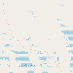
Map view of Lake Gairdner National Park

Use this park location map to pinpoint Lake Gairdner National Park in Australia, understand its exact geographic position, and read its mapped placement within the surrounding landscape more clearly.

Pigeon | © OpenStreetMap contributors

Location context for Lake Gairdner National Park

South Australia
Natural feature types

Examine the Natural Feature Dataset for Lake Gairdner National Park

View the geographic collection of named features within Lake Gairdner National Park to understand the park's physical composition. MoriAtlas provides this structured landscape index to help users trace the distribution of salt lakes and arid plains across this protected South Australian territory.
Park atlas

Trace the arid interior's mapped geography, comparing surrounding salt lake systems and diverse conservation landscapes across South Australia.

Discover Other National Parks and Protected Areas Near Lake Gairdner National Park, South Australia

Continue your exploration beyond Lake Gairdner National Park by browsing other protected areas, including additional salt lakes and arid landscapes within South Australia's vast interior. Compare geographic features, ecological profiles, and conservation statuses to gain a broader understanding of the region's unique protected landscapes and their interconnectedness.
National parkSouth Australia
29 km away#1 closest

South

Gawler Ranges National Park: South Australia's Mapped Protected National Landscape

Explore the geography and protected area context of this national park.

Gawler Ranges National Park stands as a significant protected area within the geographic expanse of South Australia. Designated as a national park, it offers valuable insights into Australia's conservation landscapes and regional geography. Users can explore its mapped boundaries and understand its unique role within the national park system, making it a key point for structured geographic study and atlas-based discovery of protected lands.

Area
1,628.75 km²
Established
2002
IUCN
VI
Relief
Mountain
Nature reserveSouth Australia
About 55 km away#2 closest

North

Bon Bon Reserve: Geographic Profile of a South Australian Nature Reserve

Arid outback landscapes and protected habitat connectivity

Spanning over 2,164 square kilometres, Bon Bon Reserve is a significant nature reserve in the arid South Australian interior. This mapped landscape features a diverse mosaic of mulga woodlands, bluebush plains, and ephemeral salt lake systems that provide a vital refuge for threatened species and secure ecological connectivity across the outback.

Area
2,164.53 km²
Established
2008
IUCN
II
Relief
Lowland
State or regional parkSouth Australia
About 71 km away#3 closest

South

Corrobinnie Hill Conservation Park: Mapped Protected Landscapes and Geological Features

A remote conservation site on the Eyre Peninsula

Corrobinnie Hill Conservation Park protects an exceptional granite outcrop that stands as a natural monument within the South Australian landscape. The site is characterized by its weathered rock formations and its geographic connection to the broader Pinkawillinie conservation estate, offering insight into the geological diversity of remote Eyre Peninsula pastoral country.

Area
2.08 km²
Established
1983
IUCN
III
Relief
Upland
Wildlife reserveSouth Australia
73 km away#4 closest

Southwest

Gawler Ranges Conservation Park: Mallee Landscapes and Regional Protected Areas

Semi-arid habitat and rocky terrain of South Australia

Gawler Ranges Conservation Park protects a core area of tree mallee woodland and rocky rises near the southern fringe of the Gawler Ranges. This wildlife reserve serves as an essential anchor for regional biodiversity on the Eyre Peninsula, offering a look at the arid-adapted vegetation and weathered geological structures that define this remote section of South Australia.

Area
154.8 km²
Established
1993
IUCN
VI
Relief
Upland
Nature reserveSouth Australia
97 km away#5 closest

South

Caralue Bluff Conservation Park: A Protected Nature Reserve on the Eyre Peninsula

Mapping regional landscape integrity in South Australia

Caralue Bluff Conservation Park encompasses a 21.5 square kilometre tract of land in South Australia, acting as a crucial element of the Eyre Peninsula landscape. Named for the nearby Caralue Bluff landform, this nature reserve safeguards essential bushland habitats within a highly developed rural setting. Analyze the park boundaries and terrain characteristics to better appreciate its function as a conserved natural refuge.

Area
21.57 km²
Established
1993
IUCN
VI
Scope
Terrestrial
National parkSouth Australia
113 km away#6 closest

East

Lake Torrens National Park: Explore South Australia's Remarkable Inland Salt Lake Geography

A unique protected landscape of arid plains and expansive salt flats.

Lake Torrens National Park offers an unparalleled exploration of Australia's remote outback, centered around a vast, ancient salt lake basin. This national park in South Australia provides a canvas of stark, minimalist terrain, featuring shimmering saltpans, arid gibber plains, and rocky outcrops. Understand the park's unique geographic identity, its ecological significance as a temporary wetland habitat, and its dramatic visual appeal for landscape photography and geological interest. It is a key protected area showcasing the extreme environment of Australia's interior.

Area
5,676.68 km²
Established
1991
IUCN
VI
Relief
Lowland
Wildlife reserveSouth Australia
119 km away#7 closest

South

Darke Range Conservation Park: A Protected Woodland Sanctuary in South Australia

Geographic landscape and regional habitat exploration

Located near Darke Peak, this wildlife reserve safeguards threatened native peppermint gum woodland. The park functions as an ecologically significant pocket of intact vegetation, providing a window into the natural ridge terrain of the Eyre Peninsula that remains distinct from the surrounding rural land.

Area
6.93 km²
Established
1985
IUCN
VI
Relief
Mountain
Nature reserveSouth Australia
About 120 km away#8 closest

South

Carappee Hill Conservation Park: Atlas and Geographic Protected Area Profile

Nature reserve geography and Eyre Peninsula landscape context

Carappee Hill Conservation Park covers 8.5 square kilometres of rocky, elevated terrain in the locality of Darke Peak. As a designated conservation area and IUCN Category III site, it serves as a critical refuge for native vegetation, providing a clear map of protected landform heritage in central South Australia.

Area
8.5 km²
Established
1973
IUCN
III
Relief
Upland

Common questions about visiting, size, designation, and location context for Lake Gairdner National Park

Lake Gairdner National Park FAQs for park facts, access, geography, and protected area context

Find quick answers about Lake Gairdner National Park, including protected-area facts, park geography, trail and visitor context, and how the park fits into its surrounding country and regional landscape.
MoriAtlas Explorer

Continue Your Protected Areas Search Across the Global Atlas

Deepen your exploration by continuing the structured search for national parks and protected areas worldwide. Utilize the comprehensive filtering capabilities to compare different conservation landscapes and refine your understanding of global park geography. Discover more about the distribution and characteristics of protected natural areas.

Global natural geography