

Mori Atlas logo
National parkCapoompeta National Park

Discover the geographic context and mapped boundaries of this New South Wales national park.

Capoompeta National Park: A Protected Landscape within New South Wales

Capoompeta National Park stands as a protected natural area within the expansive geography of New South Wales, Australia. This page offers an atlas-driven exploration of its designated national park status, focusing on its unique landscape characteristics and its place within the broader regional context. Understand the mapped boundaries and protected lands that define Capoompeta National Park, providing essential geographic insight for discovery and reference.

National ParkNew South WalesDry ForestRainforestMountain LandscapeFern Basins

Capoompeta National Park

National park

Park overview

Structured park overview, official facts, and landscape profile for Capoompeta National Park

Capoompeta National Park park facts, protected area profile, and essential visitor context

Review the core facts for Capoompeta National Park, including designation, size, terrain, visitor scale, habitats, and operating context in one park-focused overview.

About Capoompeta National Park

Capoompeta National Park sits within the northern highlands of New South Wales, preserving a mountain landscape of considerable ecological significance despite its modest area. The park's position on the New England tableland creates a transition zone between different forest types, with dry eucalypt forests dominating the exposed ridges and more humid rainforest communities occupying the sheltered gullies and fern-rich basins. This topographic variation supports a mosaic of habitats that supports diverse plant and animal communities. The park's relative youth, established in 1999, means it represents a more recent addition to New South Wales's protected area network, designated to preserve the outstanding natural values of this mountainous terrain. Unlike many other national parks in the state, Capoompeta remains essentially undeveloped, with no visitor facilities, picnic areas, or camping grounds provided. This lack of infrastructure preserves the park's wild character and makes it suitable primarily for self-sufficient visitors comfortable with dispersed outdoor exploration.

Quick facts and research context for Capoompeta National Park

Capoompeta National Park covers approximately 39 square kilometres of mountainous terrain in the New England region of New South Wales. The park was officially established in 1999 under the management of the NSW National Parks and Wildlife Service. The landscape features a distinctive mix of dry forests, closed rainforests, and unique fern basins that create microhabitats throughout the area. The park is accessible via scenic roads connecting to nearby towns including Glen Innes, Deepwater, and Tenterfield, though visitors should note that no formal facilities or services are provided within the park boundaries.

Protection and recognition

Documenting official terrestrial boundaries and conservation timelines in the regional system.

Capoompeta National Park Protection Status and Designation History

Geographic records outline the terrestrial protection status of Capoompeta National Park, established in 1999 to secure its regional landscape. Accessing official boundary designations helps researchers and conservation explorers track the formal management scope of individual reserves.

Protection details

Protection scope
Terrestrial
Designated year
1999
Transboundary protection
No
Park context

Deeper park guide and search-rich context for Capoompeta National Park

Capoompeta National Park history, landscape, wildlife, and travel context

Explore Capoompeta National Park through its history, landscape character, ecosystems, wildlife, conservation priorities, cultural context, and seasonal travel timing in a structured park guide built for atlas discovery and search intent.

Why Capoompeta National Park stands out

Capoompeta National Park is best known for its remarkable ecological diversity within a relatively compact mountain landscape. The park protects significant areas of both dry sclerophyll forest and subtropical rainforest, creating a mosaic of habitats unusual in the New England tableland. The fern basins scattered throughout the park represent a particularly distinctive landscape feature, supporting specialised plant communities in the moist valley floors. These diverse habitats make the park particularly important for wildlife conservation in the region.
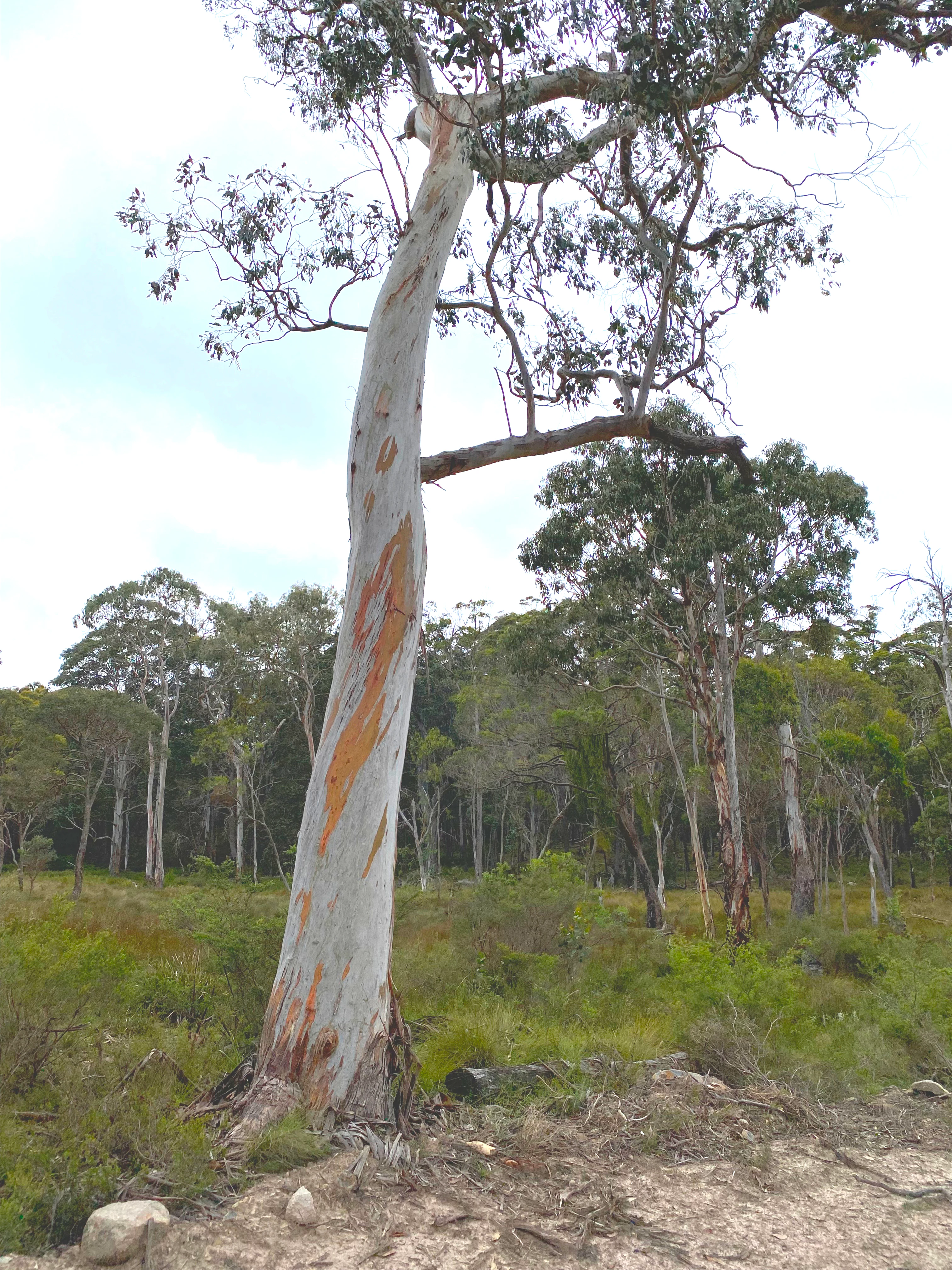
Tall eucalyptus tree with white and orange bark standing in a forested area with green undergrowth
Tall eucalyptus tree with peeling bark in Capoompeta National Park forest

Capoompeta National Park history and protected-area timeline

Capoompeta National Park was established in 1999 when it was formally declared as a protected area under the National Parks and Wildlife Act. The creation of the park reflected growing recognition during the 1990s of the ecological significance of the New England tableland's mountain forests and the need to protect the unique fern basin communities found in the region. The park was assigned IUCN Category II status, reflecting its primary purpose of ecosystem conservation and natural landscape preservation. Management of the park falls to the NSW National Parks and Wildlife Service, which continues to oversee protection of the area's natural values while allowing public access for nature-based recreation.

Capoompeta National Park landscape and geographic character

The terrain of Capoompeta National Park is defined by its mountainous character, with elevations varying across the park's 39 square kilometre extent. The landscape features a series of ridges and valleys that create diverse microclimates and forest communities. The fern basins represent a particularly distinctive landscape feature, these are moist, sheltered depressions where ferns and moisture-loving plants thrive in contrast to the surrounding dry forest landscapes. Dry sclerophyll forest predominates on the steeper slopes and ridgelines, while the more protected valleys and lower areas support closed rainforest communities. The park's position away from major population centres has helped preserve its natural landscape character since European settlement.

Capoompeta National Park ecosystems, habitats, and plant life

The ecological character of Capoompeta National Park is defined by the mixing of dry forest and rainforest communities across the mountainous terrain. This diversity of forest types within a relatively small area creates important habitat heterogeneity that supports a range of plant species. The fern basins represent specialised wetland-like environments that support plant communities adapted to constant moisture and shade. These unique microhabitats contribute significantly to the park's overall biodiversity value, creating refuge areas for species that require humid conditions. The transition between dry and wet forest types across the park's topography reflects the influence of aspect, elevation, and soil moisture on vegetation patterns in this part of New South Wales.

Capoompeta National Park wildlife and species highlights

The diverse forest habitats within Capoompeta National Park provide important environments for native wildlife species adapted to the New England region's conditions. The mix of dry forest and rainforest communities supports different assemblages of animals throughout the park, with species moving between habitat types according to season and resource availability. The protected status of the area ensures that these wildlife communities have access to relatively intact habitats, away from the heavy development pressures that have affected much of the surrounding agricultural landscape. While specific species details are limited in available sources, the park's conservation significance derives from its role in protecting connected habitats across the New England tableland.

Capoompeta National Park conservation status and protection priorities

The establishment of Capoompeta National Park in 1999 represented a significant contribution to conservation of the New England region's biodiversity. The park protects a representative sample of the mountain forest ecosystems that characterise this part of northern New South Wales, including both the widespread dry sclerophyll forests and the more restricted rainforest communities found in the sheltered valleys. The IUCN Category II designation reflects the park's primary function as a protected area for ecosystem conservation rather than recreational use. The fern basins within the park represent particularly sensitive environments that benefit from formal protection, as these moist microhabitats could easily be degraded by inappropriate activities or development. By preserving this mountainous landscape in a relatively undeveloped state, the park helps maintain ecological connectivity across the New England tableland.

Capoompeta National Park cultural meaning and human context

The Capoompeta area lies within the traditional country of Aboriginal peoples who have long inhabited the New England region of New South Wales. The mountain landscapes and diverse forest environments of this area would have provided resources for Indigenous communities over many thousands of years, though detailed historical documentation of traditional Aboriginal use of the specific park area is limited in readily available sources. The landscape's modern management under the NSW National Parks and Wildlife Service represents a continuation of protective stewardship over these lands, though the park does not carry specific indigenous heritage designations in the available source material.

Top sights and standout views in Capoompeta National Park

The standout features of Capoompeta National Park include its remarkable forest diversity within a compact mountain landscape, the distinctive fern basins that create unique ecological pockets throughout the terrain, and its wild undeveloped character that offers a remote wilderness experience. The park's location near several regional towns including Glen Innes, Deepwater and Tenterfield makes it accessible for day visits, while the absence of facilities ensures that those who venture here experience a genuine backcountry environment. The scenic drives leading to the park from these towns themselves offer attractive forest and highland scenery.

Best time to visit Capoompeta National Park

The best time to visit Capoompeta National Park would be during the cooler months of autumn and winter when the weather is more comfortable for bushwalking and forest exploration. The New England region's climate means that summer can be hot and dry, potentially making extended outdoor activity less comfortable. Winter temperatures in the highlands can be cold, particularly at night, but the clear skies and reduced humidity often provide pleasant daytime conditions for walking. Visitors should be self-sufficient as no facilities exist within the park, and those planning to explore the fern basins or longer trails should ensure they have appropriate navigation equipment and supplies.

Monthly climate preview

Tracing long term monthly temperature ranges and precipitation averages for the protected forest.

Annual Climate Patterns and Weather by Month in Capoompeta National Park

Long term climatology at the representative elevation of 889 meters reveals notable thermal variations, with average minimums below freezing during cooler months and maximums exceeding 34 degrees Celsius. Accessing the complete twelve month profile provides detailed insights into monthly climate normals and average precipitation cycles.
Annual mean15 °C
8 °C21 °C
Jan21°
Feb20°
Mar18°
Apr15°
May12°
Jun
Jul
Aug
Sep13°
Oct16°
Nov18°
Dec20°
Warmest month
January

21.2 °C

Coolest month
July

7.8 °C

Wettest month
January

3.7 mm/day

Driest month
July

1.1 mm/day

Park location guide

Geography guide, regional context, and park location map for Capoompeta National Park

Capoompeta National Park park geography, regions, and map view in Australia

Understand where Capoompeta National Park sits in Australia through a broader geographic reading of the surrounding landscape, nearby location context, and its mapped position within the national park landscape.

How Capoompeta National Park fits into Australia

Australia is a constitutional monarchy and federal parliamentary democracy comprising six states and ten territories. With a population of nearly 28 million, it is one of the world's most urbanised countries, with most people concentrated on the eastern seaboard. The country has a high Human Development Index and is known for its cultural diversity, ancient Aboriginal heritage, and unique wildlife.

Wider geography shaping Capoompeta National Park in Australia

Australia occupies the entire Australian continent, the island of Tasmania, and numerous smaller islands. It is the world's flattest and driest inhabited continent, featuring vast deserts in the interior (the Outback), tropical rainforests along the eastern coast, and a coastline bordering the Indian and Pacific Oceans.

Map view of Capoompeta National Park

Use this park location map to pinpoint Capoompeta National Park in Australia, understand its exact geographic position, and read its mapped placement within the surrounding landscape more clearly.

Pigeon | © OpenStreetMap contributors

Location context for Capoompeta National Park

New South Wales
Recorded earthquake history

Explore the Historical Earthquake Catalogue for Capoompeta National Park

Access historical seismic records associated with the geography of Capoompeta National Park. Use this curated catalogue to review past earthquake events, including magnitude and epicentre distance, as part of the broader MoriAtlas geographic and environmental collection.

Capoompeta National Park Earthquake History

Catalogued events

1 event

Strongest magnitude

Magnitude 3.3

Most recent event

Oct 11, 1981

This history includes earthquakes recorded inside the park or within 50 km of its borders

Visual Atlas of Capoompeta's Unique Protected Habitats and New England Tableland Environments

Capoompeta National Park Photos: Explore Mountainous Landscapes, Diverse Forests, and Wilderness Scenery

Explore visual imagery of Capoompeta National Park, featuring its mountainous terrain, diverse forest types including dry sclerophyll and rainforests, and distinctive fern basins. These photographs provide essential insights into the park's unique landscapes and protected environments across the New England tableland region.

Tall eucalyptus tree with white and orange bark standing in a forested area with green undergrowth

Park atlas

Explore surrounding protected landscapes and compare adjacent wilderness areas across the New England tableland region.

Discover Other National Parks and Protected Areas Near Capoompeta National Park in New South Wales

Browse a curated list of national parks and other protected areas situated near Capoompeta National Park, encompassing the diverse mountain landscapes and unique forest types of northern New South Wales. This geographic overview helps compare conservation efforts and understand the regional spread of protected habitats, offering deeper context for Australia's New England tableland.
National parkNew South Wales
1.6 km away#1 closest

East

Washpool National Park National Park: Protected Area Atlas and New South Wales Geography

Explore the mapped boundaries and natural landscape context.

Washpool National Park represents a significant protected area within the geographic landscape of New South Wales. This entry provides a structured exploration of its identity as a national park, focusing on its mapped boundaries, regional distribution, and the natural terrain it encompasses. Understand its role within a broader atlas of protected lands and its unique geographic characteristics.

Area
587 km²
Established
1983
IUCN
II
Relief
Mountain
National parkNew South Wales
6.8 km away#2 closest

South

Butterleaf National Park: National Park Protected Landscape with Regional Geographic Context

Mapped boundaries and terrain within New South Wales.

Butterleaf National Park represents a distinct national park entity within the geographic landscape of New South Wales. This resource provides a focused atlas view, detailing the park's protected boundaries and its specific contribution to the regional terrain. Users can explore the mapped geography and understand the park's identity as a significant protected natural area, offering foundational data for landscape context and conservation analysis.

Area
30 km²
Established
1999
IUCN
II
Scope
Terrestrial
National parkNew South Wales
21 km away#3 closest

Southeast

Gibraltar Range National Park: New South Wales Protected Landscape Explorer

Mapped park boundaries and regional geography of a key national park.

Delve into the protected landscape identity of Gibraltar Range National Park, a significant national park situated in New South Wales. This page offers detailed insights into its mapped boundaries and its place within the broader regional geography. Understanding Gibraltar Range National Park provides essential context for exploring Australia's network of protected areas and appreciating the diverse natural terrain it safeguards.

Area
253 km²
Established
1987
IUCN
Ib
Relief
Mountain
National parkNew South Wales
25 km away#4 closest

Southeast

Barool National Park: National Park Discovery and Geographic Context

Mapped protected area within New South Wales.

Barool National Park is identified as a protected national park, contributing to the rich tapestry of natural landscapes across New South Wales. Understanding its specific location and mapped boundaries is essential for appreciating its role within the regional geography of Australia. This entry provides a factual basis for exploring the park's identity as a defined protected area, offering a unique point of reference for geographic discovery.

Area
112.44 km²
Established
1999
IUCN
II
Climate
Temperate
National parkNew South Wales
25 km away#5 closest

Southeast

Nymboida National Park: A Protected National Park in New South Wales with Mapped Geographic Context

Explore its protected landscape and regional park geography

Nymboida National Park is a key protected area within the state of New South Wales, Australia. This page provides essential details for atlas exploration, focusing on its mapped boundaries and the geographic context it occupies. Understand the park's identity as a national park and its contribution to the protected landscape of the region, offering insights into its natural terrain and regional distribution.

Area
316 km²
Established
1980
IUCN
Ib
Relief
Mountain
Nature reserveNew South Wales
About 32 km away#6 closest

South

Mann River Nature Reserve: Geography and Protected Forest Terrain in New South Wales

Highland river valleys and Great Dividing Range landscapes

Spanning over 7,000 hectares of rugged highland terrain, Mann River Nature Reserve provides a vital protected habitat within the Northern Tablelands. The landscape is defined by the incision of the Mann River through deep, forested gorges and sharp mountain ridges, creating a distinct physical setting that serves as a sanctuary for native Australian wildlife.

Area
71.28 km²
Established
1985
IUCN
II
Relief
Mountain
National parkNew South Wales
37 km away#7 closest

North

Bald Rock National Park: Detailed National Park Atlas and Protected Landscape Context

Explore its mapped boundaries and natural terrain within New South Wales.

Bald Rock National Park serves as a key protected area for understanding regional geography and mapped landscapes in New South Wales. This page offers an atlas-centric view of the park, detailing its protected boundaries and providing context for its natural terrain. It is designed for users seeking structured information about national parks and their geographic significance, contributing to a comprehensive understanding of Australia's conservation lands.

Area
88.83 km²
Established
1971
IUCN
II
Relief
Mountain
National parkNew South Wales
40 km away#8 closest

North

Basket Swamp National Park: New South Wales National Park and Protected Landscape Mapping

Geographic context and mapped boundaries within Australia.

Basket Swamp National Park represents a significant protected area within New South Wales, Australia. This page offers a geographic exploration of its specific location, mapped boundaries, and its role as a national park. Delve into the landscape context and atlas-level understanding of this natural reserve, distinct within the broader regional geography.

Area
28.2 km²
Established
1999
IUCN
II
Relief
Lowland

Common questions about visiting, size, designation, and location context for Capoompeta National Park

Capoompeta National Park FAQs for park facts, access, geography, and protected area context

Find quick answers about Capoompeta National Park, including protected-area facts, park geography, trail and visitor context, and how the park fits into its surrounding country and regional landscape.
MoriAtlas Explorer

Continue Your Protected Areas Search Across the Global Atlas

Deepen your exploration by continuing the structured search for national parks and protected areas worldwide. Utilize the comprehensive filtering capabilities to compare different conservation landscapes and refine your understanding of global park geography. Discover more about the distribution and characteristics of protected natural areas.

Global natural geography