Mori Atlas logo
National parkCerro El Copey National Park

Discover the protected landscape of Cerro El Copey National Park in Nueva Esparta.

Cerro El Copey National Park: National Park Geography and Mapped Protected Area Boundaries

(Cerro El Copey-Jóvito Villalba National Park)

Cerro El Copey National Park stands as a significant protected national park within the region of Nueva Esparta. This detail page provides an in-depth atlas perspective, focusing on the park's geographic setting and the extent of its protected land boundaries. Users can explore the mapped terrain and understand the unique protected landscape that defines Cerro El Copey National Park, offering a factual foundation for geographic discovery.

National ParkMontane ForestIsland EcosystemImportant Bird AreaEndemic SpeciesCaribbean

Cerro El Copey National Park

National park

Park overview

Structured park overview, official facts, and landscape profile for Cerro El Copey National Park

Cerro El Copey National Park park facts, protected area profile, and essential visitor context
Review the core facts for Cerro El Copey National Park, including designation, size, terrain, visitor scale, habitats, and operating context in one park-focused overview.

About Cerro El Copey National Park

Cerro El Copey National Park sits in the eastern portion of Margarita Island, which lies off the northern coast of Venezuela in the Caribbean Sea. The park occupies the island's highest mountainous region within Nueva Esparta State, created specifically in 1974 to protect an outstanding physiographic feature and the ecosystems it supports. The mountain rises approximately 960 meters above sea level, a height sufficient to intercept moisture-bearing trade winds and create a fundamentally different environment from the arid plains that dominate most of Margarita Island. This elevation generates a cool, humid microclimate that sustains green forests and montane grasslands in what would otherwise be a desert landscape. The park contains several distinct plant formations adapted to these unique conditions and supports remarkably high levels of endemism, with many species found nowhere else on Earth. The permanent water sources found within the park represent a critical resource for the island, as they provide the only reliable freshwater supply in an otherwise water-scarce environment. Despite its protected status, the park faces challenges from surrounding villages and plantations, some of which have expanded into park grounds in recent years, creating ongoing management concerns for conservation authorities.

Quick facts and research context for Cerro El Copey National Park

Cerro El Copey National Park occupies the highest mountainous region of Margarita Island in Nueva Esparta State, Venezuela. The park covers 71 square kilometers and was established on February 27, 1974, designated under IUCN Category II as a national park. The peak reaches approximately 960 meters above sea level, creating a cool, humid microclimate amid the otherwise arid island landscape. This elevation allows the park to capture moisture from trade winds, supporting green forests and montane grasslands that contrast sharply with the desert plains surrounding the protected area. The park has been recognized as an Important Bird Area by BirdLife International due to its significance for multiple bird species.

Park context

Deeper park guide and search-rich context for Cerro El Copey National Park

Cerro El Copey National Park history, landscape, wildlife, and travel context
Explore Cerro El Copey National Park through its history, landscape character, ecosystems, wildlife, conservation priorities, cultural context, and seasonal travel timing in a structured park guide built for atlas discovery and search intent.

Why Cerro El Copey National Park stands out

Cerro El Copey National Park is best known for containing the only permanent water sources on Margarita Island, a function that makes it ecologically vital for the entire island. The park preserves a rare montane forest ecosystem that exists in stark contrast to the desert environment surrounding it, with forests and grasslands fed by humidity from northeast trade winds. It supports high levels of plant endemism and has been designated an Important Bird Area due to significant populations of several bird species. The park's position as the highest point on Margarita Island provides it with a distinctive landscape character within the Venezuelan Caribbean.

Cerro El Copey National Park history and protected-area timeline

Cerro El Copey National Park was established on February 27, 1974, with the specific purpose of protecting the outstanding natural features of Margarita Island's highest mountain. The creation of the park reflected growing recognition in Venezuela during the 1970s of the need to preserve unique island ecosystems and critical water resources. The park was later officially named Cerro El Copey-Jóvito Villalba National Park, honoring a notable Venezuelan figure while maintaining the original descriptive name. In recognition of its ecological significance, BirdLife International designated the park as an Important Bird Area, acknowledging its role in supporting significant populations of bird species. The park's establishment also aimed to preserve the island's only permanent water sources, a function that gives the protected area importance far beyond its relatively small size. The history of human settlement around the park's boundaries has created ongoing challenges, as agricultural expansion and residential development have increasingly pressed against park borders.

Cerro El Copey National Park landscape and geographic character

The landscape of Cerro El Copey National Park is defined by its dramatic elevation relative to the surrounding terrain. The mountain rises abruptly from the desert plains of Margarita Island, creating a striking visual contrast between the green montane forests of the park and the arid lowlands that surround it. The park encompasses the highest peaks of the island, with the summit at approximately 960 meters providing sweeping views across the Caribbean. The terrain includes forested slopes, montane grasslands, and the valleys that contain the island's permanent water sources. The trade winds that sweep across the Caribbean from the northeast are captured by the mountain's height, depositing moisture that sustains the forest ecosystem. In the lower areas of the park, dry and semi-deciduous forests predominate, while higher elevations support more humid forest types and grassland meadows. This vertical zonation of vegetation creates a diverse landscape within the relatively small area of the park.

Cerro El Copey National Park ecosystems, habitats, and plant life

The nature of Cerro El Copey National Park centers on a unique montane forest ecosystem that exists in remarkable isolation within the Caribbean island environment. The park contains several distinct plant formations adapted to the moisture gradients created by elevation and wind exposure. The montane forests receive humidity from the trade winds, creating conditions that support plant species more typical of mainland mountain environments than typical Caribbean island flora. High levels of endemism characterize the park's botanical diversity, with numerous species found only within this protected area and not elsewhere in the world. The permanent water sources represent a fundamental ecological feature, supporting riparian vegetation and providing critical habitat for various species. The contrast between the park's humid interior and the surrounding desert plains creates a biodiversity island within an island, with species adapted to these unique conditions facing significant conservation pressure.

Cerro El Copey National Park wildlife and species highlights

Cerro El Copey National Park has been recognized as an Important Bird Area by BirdLife International due to its significance for bird populations. The park supports significant populations of several bird species that depend on the montane forest habitat. The unique ecological conditions created by the mountain's elevation and moisture patterns support bird communities that differ from those found in the surrounding lowland areas. While the source material does not provide detailed species lists, the IBA designation indicates that the park contains bird species of conservation concern requiring protection. The forest and grassland habitats provide diverse foraging and nesting opportunities, while the permanent water sources attract species that depend on reliable freshwater access. The park's isolation on Margarita Island and its unique plant communities create conditions that support specialized bird species adapted to this particular environment.

Cerro El Copey National Park conservation status and protection priorities

Cerro El Copey National Park holds significant conservation importance for multiple reasons. The park preserves the only permanent water sources on Margarita Island, a resource of immense practical value for the island's human population and ecological systems. The high levels of endemism found within the park mean that many species exist nowhere else, making protection of this area essential for global biodiversity conservation. The montane forest ecosystem represents a rare habitat type in the Caribbean, existing in only a few isolated locations. The Important Bird Area designation by BirdLife International acknowledges the park's role in protecting significant bird populations. However, the park faces ongoing conservation challenges from surrounding agricultural and residential development, with plantation expansion and village growth encroaching on park boundaries. These pressures highlight the difficulty of protecting isolated mountain ecosystems within heavily populated island environments.

Cerro El Copey National Park cultural meaning and human context

Cerro El Copey National Park is situated on Margarita Island, one of the Venezuelan Caribbean islands with a long history of human settlement and economic activity. The park's boundaries sit amid a landscape that includes both traditional villages and agricultural plantations. The relationship between the local communities and the mountain has historically centered on the water resources it provides, as the permanent springs have been essential for island survival in an otherwise water-scarce environment. The park was named Cerro El Copey-Jóvito Villalba National Park, attaching local historical significance to the protected area. The surrounding agricultural landscape includes plantations that have in recent years expanded into park grounds, creating tension between traditional land use patterns and conservation objectives. This context reflects the broader challenge of balancing human community needs with environmental protection on Caribbean islands.

Top sights and standout views in Cerro El Copey National Park

The standout features of Cerro El Copey National Park include its role as the highest point on Margarita Island, the island's only permanent water sources, and a montane forest ecosystem that contrasts dramatically with the surrounding desert landscape. The park preserves exceptional plant endemism within a Caribbean island context and has been recognized internationally as an Important Bird Area. The combination of elevation, moisture from trade winds, and protected status creates a unique ecological island within the arid Venezuelan Caribbean environment. The park provides critical ecosystem services through its water resources while serving as a refuge for species adapted to conditions found nowhere else.

Best time to visit Cerro El Copey National Park

The park can be visited throughout the year, though the character of the experience varies with seasonal weather patterns. The montane environment remains cooler than the surrounding lowlands due to its elevation, providing relief from the intense Caribbean heat. The trade winds that supply moisture to the forest are most consistent during the typical trade wind season, contributing to the steady humidity that sustains the ecosystem. Visitors interested in bird observation should consider that different species may be more active during different seasons, though the park's IBA status ensures year-round significance for avian diversity. The dry and semi-deciduous forests in lower elevations may show seasonal changes in appearance, with deciduous species losing leaves during drier periods.
Park location guide

Geography guide, regional context, and park location map for Cerro El Copey National Park

Cerro El Copey National Park park geography, regions, and map view in Venezuela
Understand where Cerro El Copey National Park sits in Venezuela through a broader geographic reading of the surrounding landscape, nearby location context, and its mapped position within the national park landscape.

How Cerro El Copey National Park fits into Venezuela

Venezuela is a country in northern South America with coastline along the Caribbean Sea and Atlantic Ocean. It borders Colombia, Brazil, Guyana, and Trinidad and Tobago. The country has an area of approximately 916,445 km² and a population of about 31.8 million. Caracas is the capital and largest city. Venezuela consists of 23 states and the Capital District.

Wider geography shaping Cerro El Copey National Park in Venezuela

Venezuela is located on the northern coast of South America. The continental territory is bordered by the Caribbean Sea and Atlantic Ocean to the north, Colombia to the west, Brazil to the south, and Guyana to the east. Trinidad and Tobago lies to the northeast. The country includes various islands and islets in the Caribbean Sea known as the Federal Dependencies.

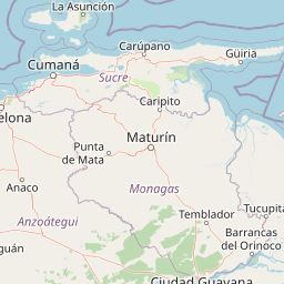
Map view of Cerro El Copey National Park

Use this park location map to pinpoint Cerro El Copey National Park in Venezuela, understand its exact geographic position, and read its mapped placement within the surrounding landscape more clearly.

Pigeon | © OpenStreetMap contributors

Location context for Cerro El Copey National Park

Nueva Esparta
Park atlas

Trace the regional geography and protected-area spread across the Venezuelan Caribbean, comparing landscapes near Cerro El Copey.

Explore Nearby National Parks and Protected Areas Around Cerro El Copey National Park
After exploring Cerro El Copey National Park, discover additional national parks and protected areas across Margarita Island and the broader Venezuelan Caribbean. Compare diverse montane, coastal, and island ecosystems, tracing the geographic context and conservation efforts within this unique regional atlas.
National parkSucre State

Turuépano National Park: National Park Protected Landscape and Geographic Context

Explore the mapped boundaries and natural terrain of Sucre State's national park.

Investigate Turuépano National Park, a protected national park situated within Sucre State, Venezuela. This entry provides detailed geographic context and information on its mapped protected-area boundaries, essential for understanding its role in the region's natural landscape atlas. Explore the specific terrain and protected land features that define this significant Venezuelan park.

Area
726 km²
Established
1991
IUCN
II
Relief
Lowland
National parkMonagas

Cueva del Guácharo National Park: Venezuela's Protected Natural Landscape

Mapping protected areas and natural terrain in Monagas.

Cueva del Guácharo National Park represents a distinct protected landscape within Venezuela's Monagas region. This entry provides essential context for understanding the park's geographic scope, mapped boundaries, and role as a national park. It is designed to facilitate detailed atlas exploration of protected natural areas and their regional landscape context, offering a foundation for understanding Venezuela's conservation geography.

Area
627 km²
Established
1975
IUCN
II
Relief
Mountain
National parkSucre

Península de Paria National Park: Venezuela's Protected Landscape Geography and Atlas Context

Explore mapped park boundaries and regional geographic setting.

Discover Península de Paria National Park, a vital protected area within the Sucre region of Venezuela. This page offers a detailed look at the park's geographic identity, focusing on its mapped boundaries and its significance as a national park for atlas-based exploration. Understand its landscape context and its contribution to Venezuela's network of protected lands, providing a clear geographic overview for researchers and explorers.

Area
375 km²
Established
1978
IUCN
II
Relief
Mountain
Watercolor painting of a lagoon surrounded by green vegetation and mountains in the background
National parkMiranda State

Laguna de Tacarigua National Park: Protected Area and Miranda State Geography

Mapped natural landscape and park boundaries in Venezuela.

Laguna de Tacarigua National Park is a designated national park offering critical protected landscape features within Miranda State. This park provides essential context for understanding Venezuela's protected areas, with a focus on its mapped boundaries and regional geographic setting. Dive into the atlas-style details to comprehend its place in the natural landscape.

Area
391 km²
Established
1974
IUCN
II
Relief
Lowland
National parkMiranda

Guatopo National Park: Venezuela's National Park Mapped Landscape Context

Discover Guatopo National Park's protected area geography.

Guatopo National Park represents a key protected natural landscape in Venezuela's Miranda region. This entry offers detailed geographic context, focusing on the park's mapped boundaries and its status as a national park. It is designed for users seeking structured information about protected areas, enabling a deeper understanding of natural landscapes and their regional distribution within an atlas framework. Explore the park's distinct protected-area identity and its place in the national geography.

Area
1,224.64 km²
Established
1958
IUCN
II
Relief
Mixed relief
Watercolor painting showing a winding river flowing through a landscape with rolling hills in the background
National parkVenezuela

El Ávila National Park: Venezuela's Premier Coastal Mountain National Park Exploration

Discover diverse terrain, mapped boundaries, and unique geographic context.

El Ávila National Park offers an exceptional gateway into Venezuela's mountainous protected landscapes. This national park features a dramatic rise from the Caribbean coast into varied terrain, including unique cloud forest and alpine zones. Its mapped geography showcases steep slopes, deep ravines, and remarkable elevation changes, providing a significant atlas-style study of coastal mountain environments. Exploring El Ávila National Park reveals a vital natural barrier and a rich ecosystem supporting diverse flora and fauna, making it a key destination for understanding regional protected areas.

Area
819 km²
Established
1958
IUCN
II
Relief
Mountain
National parkVenezuela

Macarao National Park: Venezuela's National Park with Mapped Boundaries and Regional Atlas Context

Explore its protected landscape and geographic setting within South America.

Delve into Macarao National Park, a significant national park situated in Venezuela. This page offers an atlas-centric view of the park, detailing its mapped boundaries and highlighting its importance within the regional geography of northern South America. Understand how Macarao National Park contributes to the country's network of protected landscapes and provides foundational geographic context for explorers and researchers.

Area
150 km²
Established
1973
IUCN
II
Relief
Mountain
National parkVenezuela

Caura National Park: Venezuela's Largest Protected Area in the Guianan Highlands

Mapped boundaries of an immense tropical rainforest basin.

Caura National Park represents Venezuela's most extensive protected territory, established in 2017 to encompass the vast Caura River basin. This national park preserves a critical tropical rainforest ecosystem within the Guianan Highlands, contributing significantly to the Orinoco River's watershed. Its creation is the result of long-standing conservation efforts aimed at protecting millions of hectares of biodiverse landscape, offering a unique opportunity for understanding the geographic scope and ecological importance of large-scale protected areas.

Area
75,340 km²
Established
2017
IUCN
II
Climate
Tropical

Common questions about visiting, size, designation, and location context for Cerro El Copey National Park

Cerro El Copey National Park FAQs for park facts, access, geography, and protected area context
Find quick answers about Cerro El Copey National Park, including protected-area facts, park geography, trail and visitor context, and how the park fits into its surrounding country and regional landscape.
MoriAtlas Explorer

Continue Your Protected Areas Search Across the Global Atlas

Deepen your exploration by continuing the structured search for national parks and protected areas worldwide. Utilize the comprehensive filtering capabilities to compare different conservation landscapes and refine your understanding of global park geography. Discover more about the distribution and characteristics of protected natural areas.

Global natural geography