Mori Atlas logo
National parkGuatopo National Park

Discover the protected landscape boundaries and regional geography of Guatopo National Park.

Guatopo National Park: Venezuela National Park Atlas and Protected Area Exploration

(Parque Nacional Guatopo)

Guatopo National Park stands as a significant protected natural area within Venezuela's Miranda region. This page offers a detailed look at its mapped boundaries and its context within the broader national park system. Users can explore the park's unique protected landscape identity and understand its place in regional geography through an atlas-oriented lens, providing a factual basis for understanding natural areas. This provides essential data for geographic discovery and landscape context.

National ParkProtected AreaVenezuelaCordillera de la CostaForest ProtectionWatershed Conservation

Guatopo National Park

National park

Park overview

Structured park overview, official facts, and landscape profile for Guatopo National Park

Guatopo National Park park facts, protected area profile, and essential visitor context
Review the core facts for Guatopo National Park, including designation, size, terrain, visitor scale, habitats, and operating context in one park-focused overview.

About Guatopo National Park

Guatopo National Park occupies a distinctive position in Venezuela's protected area system, established in 1958 to preserve the ecological integrity of the coastal mountain region between Miranda and Guárico states. The park's territory spans the transition zone between the Cordillera de la Costa mountain range and the piedemonte llanero foothills, creating a landscape of considerable topographic and ecological diversity. The protected area was created following the identification of these lands as possessing significant natural value, with formal declaration occurring in 1958 and subsequent governmental expropriation completed by 1960. The park serves multiple conservation functions, including watershed protection for the Tuy River Valley regions, forest preservation within the coastal mountain system, and habitat conservation for the biodiversity that inhabits this transitional ecological zone.

Quick facts and research context for Guatopo National Park

Guatopo National Park is situated in northern Venezuela between Miranda and Guárico states, approximately at coordinates 10°04′N 66°25′W. The park was established in 1958 through Presidential Decree No. 257, with formal expropriation of lands completed by 1960. The landscape transitions from coastal mountain forests in the north to foothill environments in the south, encompassing the Serranía del Interior mountain extension. The protected area covers 1,224.64 square kilometers of diverse terrain.

Park context

Deeper park guide and search-rich context for Guatopo National Park

Guatopo National Park history, landscape, wildlife, and travel context
Explore Guatopo National Park through its history, landscape character, ecosystems, wildlife, conservation priorities, cultural context, and seasonal travel timing in a structured park guide built for atlas discovery and search intent.

Why Guatopo National Park stands out

Guatopo National Park is best known for its location within the Cordillera de la Costa ecosystem, representing a protected corridor between coastal mountain forests and foothill environments. The park protects important watershed areas that serve the Valleys of the Tuy region and surrounding agricultural lands. Its position along the geographic transition between the Barlovento Plain and the Serranía del Interior gives it ecological significance as a bridging habitat between distinct environmental zones.

Guatopo National Park history and protected-area timeline

The lands comprising Guatopo National Park have a documented colonial-era ownership history. The territory was originally owned by Don Pedro de Ponte Andrade Jaspe and Montenegro, and was formally registered after being purchased in 1687 by Don Francisco Araujo de Figueroa and Don Diego Fenandez de la Mota. The property later came under the ownership of Don Pedro de Ponte Andrade Jaspe and Montenegro in 1701, acquired from Maria Araujo of Figueroa, heiress of Captain Diego Fernandez de la Mota. These lands remained in private hands until the Venezuelan government recognized their ecological significance, declaring the area a national park in 1958. The formal expropriation proceeded under Presidential Decree No. 257 of April 8, 1960, published in Official Gazette No. 26230 on April 11, 1960, establishing the legal framework for the park's creation and subsequent management as a protected area.

Guatopo National Park landscape and geographic character

The physical landscape of Guatopo National Park is characterized by its position within the Venezuelan coastal mountain system. The park is bounded to the north by the Cordillera de la Costa and the Barlovento Plain, while the southern boundary meets the piedemonte llanero foothills. To the east and west, the park borders extensions of the Serranía del Interior mountain range, with the Valleys of the Tuy lying to the west. This positioning creates a landscape of considerable topographic variation, transitioning from mountain environments to foothill systems. The park encompasses watersheds that flow toward the Tuy River system, with seasonal variations in water availability influencing the broader landscape character.

Guatopo National Park ecosystems, habitats, and plant life

The ecological character of Guatopo National Park reflects its position within the Cordillera de la Costa biodiversity hotspot. As a protected area spanning the transition between coastal mountain forests and foothill environments, the park encompasses habitats associated with the Serranía del Interior extension. The vegetation patterns include forest types characteristic of the coastal mountain system, with seasonal changes influenced by regional climate patterns. The park's watershed function is particularly significant, supporting hydrological systems that serve agricultural and municipal water needs in the surrounding Tuy Valley regions.

Guatopo National Park wildlife and species highlights

The wildlife of Guatopo National Park is associated with the coastal mountain forest ecosystems of northern Venezuela. While the source material provides limited specific detail on fauna, the park's position within the Cordillera de la Costa ecosystem suggests the presence of species adapted to forest and foothill environments typical of this geographic region. The protected status of the area provides conservation benefit for wildlife populations within this transitional habitat zone.

Guatopo National Park conservation status and protection priorities

Guatopo National Park represents an important conservation designation within Venezuela's protected areas system, established in 1958 as one of the country's earlier national parks. The park's conservation significance derives from its role in protecting coastal mountain forest ecosystems, maintaining watershed functions for the Tuy Valley region, and preserving the ecological transition between the Cordillera de la Costa and piedemonte llanero environments. The IUCN designation as Category II reflects the park's primary function as a national park focused on ecosystem protection and preservation.

Guatopo National Park cultural meaning and human context

The cultural context of Guatopo National Park includes the documented colonial-era land ownership history of the territory. The land was associated with historical figures including Don Pedro de Ponte Andrade Jaspe and Montenegro, with formal property registrations dating to the late 17th century. This historical land tenure context precedes the establishment of the protected area and reflects the long human presence in this region of Venezuela.

Top sights and standout views in Guatopo National Park

The primary highlights of Guatopo National Park include its position within the Cordillera de la Costa mountain system, its role as a watershed protection area for the Tuy Valley, and its representation of the ecological transition between coastal mountains and foothill environments. The park's establishment in 1958 makes it one of Venezuela's older national parks, reflecting early recognition of the region's ecological value. The landscape features waterfalls, diverse vegetation, and seasonal environmental variations that characterize the coastal mountain environment.

Best time to visit Guatopo National Park

The best time to visit Guatopo National Park would typically align with the dry season period in Venezuela, which generally occurs from December through April. During this period, visitor access to park trail systems is more reliable and wildlife viewing opportunities may be more predictable. The wet season, from May to November, brings increased rainfall that can affect trail conditions and accessibility within the park's mountainous terrain. The dry season months offer more stable conditions for exploration of the park's landscapes and waterfalls.

Park location guide

Geography guide, regional context, and park location map for Guatopo National Park

Guatopo National Park park geography, regions, and map view in Venezuela
Understand where Guatopo National Park sits in Venezuela through a broader geographic reading of the surrounding landscape, nearby location context, and its mapped position within the national park landscape.

How Guatopo National Park fits into Venezuela

Venezuela is a country in northern South America with coastline along the Caribbean Sea and Atlantic Ocean. It borders Colombia, Brazil, Guyana, and Trinidad and Tobago. The country has an area of approximately 916,445 km² and a population of about 31.8 million. Caracas is the capital and largest city. Venezuela consists of 23 states and the Capital District.

Wider geography shaping Guatopo National Park in Venezuela

Venezuela is located on the northern coast of South America. The continental territory is bordered by the Caribbean Sea and Atlantic Ocean to the north, Colombia to the west, Brazil to the south, and Guyana to the east. Trinidad and Tobago lies to the northeast. The country includes various islands and islets in the Caribbean Sea known as the Federal Dependencies.

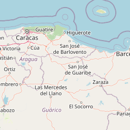
Map view of Guatopo National Park

Use this park location map to pinpoint Guatopo National Park in Venezuela, understand its exact geographic position, and read its mapped placement within the surrounding landscape more clearly.

Pigeon | © OpenStreetMap contributors

Location context for Guatopo National Park

GuáricoMiranda
Park atlas

Map surrounding protected landscapes and compare regional park geography across Venezuela's diverse coastal mountain system.

Explore Nearby National Parks and Protected Areas Connected to Guatopo National Park Geography
After exploring Guatopo National Park, trace the geographic spread of other national parks and protected areas within Venezuela's Cordillera de la Costa mountain system and its adjacent foothill environments. Compare diverse conservation landscapes, understand regional ecological connections, and find new protected areas based on their proximity and shared geographic features.
Watercolor painting of a lagoon surrounded by green vegetation and mountains in the background
National parkMiranda State

Laguna de Tacarigua National Park: Protected Area and Miranda State Geography

Mapped natural landscape and park boundaries in Venezuela.

Laguna de Tacarigua National Park is a designated national park offering critical protected landscape features within Miranda State. This park provides essential context for understanding Venezuela's protected areas, with a focus on its mapped boundaries and regional geographic setting. Dive into the atlas-style details to comprehend its place in the natural landscape.

Area
391 km²
Established
1974
IUCN
II
Relief
Lowland
Watercolor painting showing a winding river flowing through a landscape with rolling hills in the background
National parkVenezuela

El Ávila National Park: Venezuela's Premier Coastal Mountain National Park Exploration

Discover diverse terrain, mapped boundaries, and unique geographic context.

El Ávila National Park offers an exceptional gateway into Venezuela's mountainous protected landscapes. This national park features a dramatic rise from the Caribbean coast into varied terrain, including unique cloud forest and alpine zones. Its mapped geography showcases steep slopes, deep ravines, and remarkable elevation changes, providing a significant atlas-style study of coastal mountain environments. Exploring El Ávila National Park reveals a vital natural barrier and a rich ecosystem supporting diverse flora and fauna, making it a key destination for understanding regional protected areas.

Area
819 km²
Established
1958
IUCN
II
Relief
Mountain
National parkVenezuela

Macarao National Park: Venezuela's National Park with Mapped Boundaries and Regional Atlas Context

Explore its protected landscape and geographic setting within South America.

Delve into Macarao National Park, a significant national park situated in Venezuela. This page offers an atlas-centric view of the park, detailing its mapped boundaries and highlighting its importance within the regional geography of northern South America. Understand how Macarao National Park contributes to the country's network of protected landscapes and provides foundational geographic context for explorers and researchers.

Area
150 km²
Established
1973
IUCN
II
Relief
Mountain
Watercolor painting depicting mountains, a lake, and green vegetation
National parkVenezuela

Henri Pittier National Park: Venezuela's Oldest National Park, Coastal Range Geography

Explore protected landscapes, cloud forests, and birdwatching geography.

Henri Pittier National Park is Venezuela's foundational protected area, established in 1937 and spanning over 107,800 hectares within the Venezuelan Coastal Range. This national park is renowned for its exceptional biodiversity, particularly its over 500 bird species and its distinctive cloud forest ecosystems, which include the iconic Gyranthera caribensis tree. The park's geography extends from rugged mountain terrain to coastal bays and beaches, with the Paso de Portachuelo serving as a significant migratory bird corridor. Its mapped boundaries enclose a rich mosaic of natural landscapes vital for understanding regional conservation and protected area geography in northern South America.

Area
1,078 km²
Established
1937
IUCN
II
Relief
Mountain
National parkCarabobo

San Esteban National Park: Discover Carabobo's Protected Caribbean Forest Landscape

Mapped protected area and natural terrain in Venezuela.

San Esteban National Park represents a significant protected area within Venezuela's Carabobo region, offering a unique exploration of Caribbean forest ecosystems and historical cultural sites. Covering approximately 445 square kilometers, the park's terrain spans coastal areas to mountainous interiors, presenting a diverse natural landscape shaped by its position in the coastal mountain ranges. This national park is notable for its archaeological petroglyphs, colonial roads, and fortifications, providing a rich cultural heritage context alongside its natural ecosystems. Its status as a protected national park makes it a key destination for understanding the intersection of natural conservation and historical geography in Venezuela.

Area
445 km²
Established
1987
IUCN
II
Relief
Mixed relief
National parkGuárico

Aguaro-Guariquito National Park: Protected Landscape and Geographic Mapping

Explore its Guárico regional setting and mapped park boundaries.

Aguaro-Guariquito National Park stands as a vital protected natural area within the Guárico region of Venezuela. This entry offers an atlas-centric view, focusing on the park's mapped boundaries and its role as a national park. Delve into its geographic identity and the context it provides for understanding protected landscapes in the area.

Area
5,857 km²
Established
1974
IUCN
II
Relief
Lowland
National parkVenezuela

Morrocoy National Park: Venezuela's Coastal National Park with Distinct Protected Geography

Explore the mapped protected landscape and regional context.

Morrocoy National Park stands as a key protected area within Venezuela, offering a distinct focus for geographic exploration. As a national park, its mapped boundaries delineate a significant natural landscape critical for understanding regional conservation and the country's broader atlas of protected lands. Discover the unique geographic characteristics and the atlas-driven context of this important Venezuelan protected area.

Area
320.9 km²
Established
1974
IUCN
II
Relief
Mixed relief
National parkVenezuela

Yurubí National Park: A National Park in Venezuela for Protected Landscape Exploration

Explore mapped boundaries and regional geography.

Yurubí National Park represents a distinct protected area within Venezuela, offering valuable data for geographic exploration and atlas-based understanding. This national park's identity is defined by its mapped boundaries and its role in the regional landscape context of northern South America. Delve into its protected territory to gain insights into Venezuela's natural geography and conservation landscapes.

Area
236.7 km²
Established
1960
IUCN
II
Relief
Mountain

Common questions about visiting, size, designation, and location context for Guatopo National Park

Guatopo National Park FAQs for park facts, access, geography, and protected area context
Find quick answers about Guatopo National Park, including protected-area facts, park geography, trail and visitor context, and how the park fits into its surrounding country and regional landscape.
MoriAtlas Explorer

Continue Your Protected Areas Search Across the Global Atlas

Deepen your exploration by continuing the structured search for national parks and protected areas worldwide. Utilize the comprehensive filtering capabilities to compare different conservation landscapes and refine your understanding of global park geography. Discover more about the distribution and characteristics of protected natural areas.

Global natural geography