Why Macarao National Park stands out
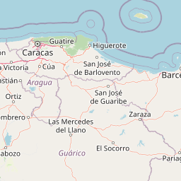
Macarao National Park is best known for its role as a watershed protection area serving Caracas water needs and its mountainous landscape within the Cordillera de la Costa. The park protects the headwaters of several rivers that flow into the capital region, making it environmentally significant beyond its recreational value. Its proximity to Caracas also makes it one of the most accessible national parks for day visitors from the capital.
Macarao National Park history and protected-area timeline
Macarao National Park was established on December 5, 1973, through official decree that designated the territory as a national park with the primary purpose of protecting the hydrographic resources of the Macarao, San Pedro, and Jarillo river basins. The creation of the park reflected Venezuela's growing commitment to environmental protection during the 1970s, a period when the country established several new protected areas. The park's establishment recognized that the watersheds feeding into the Caracas metropolitan area required formal protection to ensure sustainable water supply for the capital's growing population. The selection of this particular area for protection also acknowledged the ecological importance of the Cordillera de la Costa ecosystem, which supports distinctive biodiversity adapted to the humid subtropical conditions of Venezuela's northern mountain ranges.
Macarao National Park landscape and geographic character
The terrain of Macarao National Park is defined by its position within the Cordillera de la Costa, a mountain range that runs parallel to Venezuela's Caribbean coast. The landscape features steep mountainous slopes, ridgelines, and deep valleys carved by the rivers that flow from the higher elevations toward the lowlands. The park's highest point, Alto de Ño León, rises prominently within this terrain and offers scenic views across the surrounding coastal range. The vegetation cover varies with elevation, transitioning from lower slopes covered in humid forest to higher areas with more open vegetation patterns. River corridors dissect the mountainous terrain, creating riparian zones that contrast with the surrounding slopes. The combination of forest-covered mountains and clear watercourses creates a landscape of considerable scenic value despite its proximity to a major urban center.
Macarao National Park ecosystems, habitats, and plant life
The ecological character of Macarao National Park reflects its location in the premontane to montane zone of Venezuela's coastal mountain range. The protected area supports forest ecosystems that have adapted to the humid conditions created by moisture-laden winds from the Caribbean. These forests contain a mix of tree species typical of Central American and northern South American mountain environments. The watershed protection function of the park has helped preserve the natural vegetation cover in the upper catchment areas, which in turn maintains water quality in the rivers that flow toward Caracas. The riparian corridors along the Macarao, San Pedro, and Jarillo rivers provide habitat for aquatic species and create biodiversity corridors through the mountainous terrain. While detailed species inventories are not prominently featured in available sources, the park's protected status has preserved habitat that would otherwise face pressure from urban expansion and agricultural development in the Caracas metropolitan region.
Macarao National Park wildlife and species highlights
The wildlife of Macarao National Park is characteristic of the humid forest environments found in Venezuela's coastal mountain ranges. The park's protected status has helped maintain habitat for various bird species that inhabit the forest canopy and river margins. The riparian environments along the park's rivers support aquatic wildlife and provide foraging areas for birds that move between different elevations. The forest interior offers habitat for small mammals and other terrestrial species adapted to the premontane environment. While comprehensive species lists are not available in the source material, the park's conservation of forest habitat within the Cordillera de la Costa creates conditions suitable for maintaining biodiversity in an area increasingly influenced by nearby urban development.
Macarao National Park conservation status and protection priorities
Macarao National Park serves a critical conservation function as a protected watershed for Caracas, one of South America's largest cities. The park's designation as a national park in 1973 reflected Venezuela's recognition that protecting water catchment areas was essential for urban water security. The protection of the Macarao, San Pedro, and Jarillo river basins helps ensure sustainable flow and quality of water that contributes to the capital's drinking water supply. Beyond its watershed function, the park preserves representative examples of the Cordillera de la Costa ecosystem, which faces pressure from urban expansion and infrastructure development. The national park status provides legal protection against industrial activities, mining, and unchecked development that might otherwise degrade the mountain environment. This dual focus on water resource protection and ecosystem preservation makes the park environmentally significant beyond its value as a recreation area.
Macarao National Park cultural meaning and human context
Macarao National Park exists within a landscape that has historical connections to the areas surrounding Caracas, though detailed cultural heritage information is not prominently featured in available sources. The park's territory falls within regions that have experienced human presence as part of the broader Caracas metropolitan area's development. The park's establishment reflects modern conservation priorities that recognize the importance of protecting natural areas adjacent to major urban centers. The local communities in Miranda State and the Capital District have access to this protected natural space, which provides opportunities for environmental education and outdoor recreation. The name Macarao reflects the local toponymy of the area, and the park serves as a green buffer between the densely populated Caracas valley and the more remote mountain terrain of the coastal range.
Top sights and standout views in Macarao National Park
The standout features of Macarao National Park include its critical role in protecting water resources for Caracas, its location within the scenic Cordillera de la Costa, and its accessibility from the Venezuelan capital. The park's highest point at Alto de Ño León offers panoramic views across the coastal mountain landscape. Protected river valleys provide scenic and ecological value, while the forest-covered slopes represent preserved examples of premontane vegetation in an otherwise developing region. The park provides facilities for visitors interested in hiking, scientific excursions, and environmental education, making it a destination where recreational use and conservation coexist.
Best time to visit Macarao National Park
Macarao National Park can be visited throughout the year given its proximity to Caracas and the consistent subtropical climate of the coastal mountain range. The period from December through April typically offers drier conditions, which may be more comfortable for hiking and outdoor activities. The wet season from May to November brings higher rainfall to the mountain environment, which sustains the forest vegetation and keeps the rivers flowing but may limit some trail activities. Year-round visitation is possible, though visitors should be prepared for the humid conditions typical of this tropical mountain environment.