

Mori Atlas logo
National parkYurubí National Park

Trace the mapped boundaries and regional context of this national park in northern South America.

Yurubí National Park: Venezuela's Protected Landscape for Geographic Discovery

Yurubí National Park stands as a key protected area within Venezuela, offering critical insights into the country's natural landscapes and regional geography. As a designated national park, its mapped boundaries define a significant natural territory ideal for atlas-driven exploration. Understand how this park contributes to the broader protected land mosaic of northern South America, providing a focal point for geographic discovery and landscape context.

cloud forestsprotected watershedVenezuelan national parksSierra de Aroamontane foreststropical biodiversity

Yurubí National Park

National park

Park overview

Structured park overview, official facts, and landscape profile for Yurubí National Park

Yurubí National Park park facts, protected area profile, and essential visitor context
Review the core facts for Yurubí National Park, including designation, size, terrain, visitor scale, habitats, and operating context in one park-focused overview.

About Yurubí National Park

Yurubí National Park occupies a strategic position in the mountainous interior of Yaracuy State in northern Venezuela, within the Sierra de Aroa range that forms part of the coastal Venezuelan highlands. The park was formally established on March 18, 1960, making it one of the earlier protected areas in Venezuela's national park system. The primary conservation rationale for the park's creation was the protection of the Yurubí river basin, which provides essential freshwater supply to San Felipe, the principal city of Yaracuy. The park's elevation gradient, ranging from lower montane slopes up into higher cloud forest zones, captures moisture from Atlantic trade winds, creating the humid conditions that sustain the park's forest ecosystems. Unlike many Venezuelan protected areas that contain rural communities, Yurubí was designated as an uninhabited park, with former settlers relocated many years ago to remove human pressure from the watershed area. The surrounding landscape is dominated by agricultural cultivation, making the park's intact forest patches increasingly important for regional ecological connectivity and water regulation. Current visitor infrastructure is minimal, with informal trails used primarily by researchers studying the poorly documented biodiversity and occasionally by small numbers of adventurous visitors.

Quick facts and research context for Yurubí National Park

Yurubí National Park covers 236.7 square kilometers in the Sierra de Aroa mountains of Yaracuy State, Venezuela. Established on March 18, 1960, it was created specifically to protect the Yurubí river basin, which serves as the primary water source for San Felipe, the state capital. The park features cloud forest and low montane forest habitats at elevations that capture moisture from trade winds, creating the characteristic mist-filled canopy. Currently, the park has no permanent residents following the relocation of former inhabitants, and visitor access remains limited with only informal trails used occasionally by researchers and a small number of visitors.

Park context

Deeper park guide and search-rich context for Yurubí National Park

Yurubí National Park history, landscape, wildlife, and travel context
Explore Yurubí National Park through its history, landscape character, ecosystems, wildlife, conservation priorities, cultural context, and seasonal travel timing in a structured park guide built for atlas discovery and search intent.

Why Yurubí National Park stands out

Yurubí National Park is best known for its role as a protected cloud forest watershed serving the city of San Felipe. The park occupies the highlands of the Sierra de Aroa, where moist Atlantic trade winds create persistent cloud cover that sustains the montane forest ecosystem. While comprehensive biodiversity surveys are lacking, preliminary surveys have documented over 68 bird species, 64 bat species, 13 carnivore species, and notable primate populations, suggesting the park harbors significant Neotropical fauna. The protected area represents one of the few intact forest remnants in a region otherwise dominated by agricultural cultivation, making it ecologically important for watershed protection and biodiversity conservation in northern Venezuela.

Yurubí National Park history and protected-area timeline

Yurubí National Park was established on March 18, 1960, during a period when Venezuela was developing its national park system to protect representative samples of the country's diverse ecosystems. The park's creation was driven by the practical need to protect the Yurubí river watershed that supplies San Felipe, the capital of Yaracuy State, with fresh water. This water security motivation reflects an early understanding among Venezuelan conservation planners that forest protection could serve direct human infrastructure needs. Unlike many parks that were created around existing protected forest reserves or former hacienda lands, Yurubí was established as a new protected area with the explicit intention of removing human settlement from the watershed. The relocation of former inhabitants to surrounding areas represented a significant management decision that distinguished Yurubí from many other Venezuelan protected areas that still contain communities. Since establishment, the park has remained relatively understudied, with limited scientific research conducted within its boundaries despite its ecological potential.

Yurubí National Park landscape and geographic character

The landscape of Yurubí National Park is defined by its position in the Sierra de Aroa, a mountain range in northern Venezuela that rises from the surrounding coastal lowlands. The terrain consists of steep forested slopes and ridges characteristic of low to mid-elevation tropical mountains. The park occupies elevations where cloud formation is common, as moisture-laden trade winds from the Atlantic are forced upward along the mountain slopes, creating persistent cloud cover at the canopy level. This orographic effect is the key driver of the cloud forest ecosystem that characterizes the park. The Yurubí river and its tributaries originate within the park boundaries, descending through the mountain valleys to eventually reach the lowerlands and supply San Felipe. The forest cover, though surrounded by agricultural lands, remains relatively intact within the park's core areas, providing a contrasting green landscape to the cleared farmlands in the surrounding Yaracuy lowlands.

Yurubí National Park ecosystems, habitats, and plant life

Yurubí National Park protects cloud forest and low montane forest ecosystems that are characteristic of northern Venezuelan highlands but increasingly rare in the region. The cloud forest habitat forms at elevations where atmospheric moisture condenses on vegetation, creating conditions that support specialized plant communities adapted to persistent wetness and reduced direct sunlight. These forests typically feature dense canopy cover, abundant epiphytes including bromeliads and orchids, and high humidity throughout the year. The low montane forests occupy the transition zone below the cloud forest proper. Although comprehensive ecological surveys have not been conducted, the park's location at a biogeographic crossroads suggests it contains significant plant diversity. The protected status of the Yurubí watershed also means the park serves critical ecosystem services by regulating water flow and preventing erosion in the catchment area that supplies San Felipe.

Yurubí National Park wildlife and species highlights

While scientific documentation of Yurubí's wildlife remains limited, available surveys indicate notable biodiversity within the park. Ornithological work has recorded at least 68 bird species, representing the diverse avifauna that inhabits the cloud forest canopy and edges. The bat fauna is particularly well-documented with 64 species recorded, reflecting the importance of forest habitats for Neotropical bats that depend on diverse food resources and roosting sites. Carnivore diversity includes at least 13 species, suggesting a functional predator community. Small mammal diversity encompasses 9 rodent species and 5 marsupial species, while primate populations of 2 species have been documented. This preliminary species tally, while incomplete, suggests that Yurubí supports significant mammalian diversity despite the lack of comprehensive surveys. The combination of forest habitats, water resources, and relatively low human disturbance within the park creates conditions favorable for wildlife persistence.

Yurubí National Park conservation status and protection priorities

Yurubí National Park represents an important conservation designation in northern Venezuela, protecting what remains of the forest cover in the Sierra de Aroa region. The park's dual purpose of biodiversity conservation and watershed protection reflects an integrated approach to ecosystem management that recognizes the connections between forest health and human water security. With surrounding lands heavily converted to agriculture, the park functions as a critical refuge for forest-dependent species and as a living filter for the water supply serving San Felipe. The lack of permanent human settlement within the park boundaries reduces direct pressures such as hunting and habitat clearing that affect many other Venezuelan protected areas. However, the limited research conducted in the park means that many conservation questions about species populations, habitat threats, and management needs remain unanswered, suggesting that future conservation work would benefit from increased scientific attention.

Top sights and standout views in Yurubí National Park

Yurubí National Park offers visitors the opportunity to experience relatively pristine cloud forest in a region where such habitats are increasingly rare. The park's mountain trails provide access to scenic viewpoints and forest environments that differ dramatically from the agricultural lowlands surrounding the protected area. The diversity of documented wildlife, particularly bats and birds, makes the park potentially interesting for wildlife observation despite limited visitor infrastructure. The historical significance of the park as one of Venezuela's older protected areas, established in 1960, adds institutional context to the natural landscape. The absence of resident communities within the park means visitors experience a wilderness setting rather than the cultural landscapes found in many other Venezuelan national parks.
Park location guide

Geography guide, regional context, and park location map for Yurubí National Park

Yurubí National Park park geography, regions, and map view in Venezuela
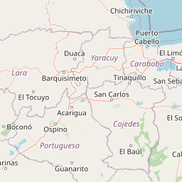
Understand where Yurubí National Park sits in Venezuela through a broader geographic reading of the surrounding landscape, nearby location context, and its mapped position within the national park landscape.

How Yurubí National Park fits into Venezuela

Venezuela is a country in northern South America with coastline along the Caribbean Sea and Atlantic Ocean. It borders Colombia, Brazil, Guyana, and Trinidad and Tobago. The country has an area of approximately 916,445 km² and a population of about 31.8 million. Caracas is the capital and largest city. Venezuela consists of 23 states and the Capital District.

Wider geography shaping Yurubí National Park in Venezuela

Venezuela is located on the northern coast of South America. The continental territory is bordered by the Caribbean Sea and Atlantic Ocean to the north, Colombia to the west, Brazil to the south, and Guyana to the east. Trinidad and Tobago lies to the northeast. The country includes various islands and islets in the Caribbean Sea known as the Federal Dependencies.

Map view of Yurubí National Park

Use this park location map to pinpoint Yurubí National Park in Venezuela, understand its exact geographic position, and read its mapped placement within the surrounding landscape more clearly.

Pigeon | © OpenStreetMap contributors

Location context for Yurubí National Park

Yaracuy State
Park atlas

Browse more cloud forests and montane protected landscapes across the Sierra de Aroa region.

Explore Other National Parks and Protected Areas Near Yurubí National Park in Northern Venezuela
Explore additional national parks and protected areas near Yurubí National Park, mapping the regional context of cloud forests and vital watersheds across northern Venezuela. Compare diverse protected landscapes and understand how conservation efforts extend beyond individual park boundaries, offering a broader geographic perspective on the region's natural heritage.
National parkVenezuela

Morrocoy National Park: Venezuela's Coastal National Park with Distinct Protected Geography

Explore the mapped protected landscape and regional context.

Morrocoy National Park stands as a key protected area within Venezuela, offering a distinct focus for geographic exploration. As a national park, its mapped boundaries delineate a significant natural landscape critical for understanding regional conservation and the country's broader atlas of protected lands. Discover the unique geographic characteristics and the atlas-driven context of this important Venezuelan protected area.

Area
320.9 km²
Established
1974
IUCN
II
Relief
Mixed relief
National parkCarabobo

San Esteban National Park: Discover Carabobo's Protected Caribbean Forest Landscape

Mapped protected area and natural terrain in Venezuela.

San Esteban National Park represents a significant protected area within Venezuela's Carabobo region, offering a unique exploration of Caribbean forest ecosystems and historical cultural sites. Covering approximately 445 square kilometers, the park's terrain spans coastal areas to mountainous interiors, presenting a diverse natural landscape shaped by its position in the coastal mountain ranges. This national park is notable for its archaeological petroglyphs, colonial roads, and fortifications, providing a rich cultural heritage context alongside its natural ecosystems. Its status as a protected national park makes it a key destination for understanding the intersection of natural conservation and historical geography in Venezuela.

Area
445 km²
Established
1987
IUCN
II
Relief
Mixed relief
National parkVenezuela

Terepaima National Park: Venezuela's National Park Protected Landscape

Mapped Boundaries and Regional Geography

Terepaima National Park is a designated national park within Venezuela, offering a clear focus for atlas-driven exploration of protected natural areas. This entry highlights the park's significance as a mapped protected landscape, providing essential geographic context and detail for understanding its boundaries and regional setting. It is an integral component for any structured discovery of Venezuela's conservation network.

Area
186.5 km²
Established
1976
IUCN
II
Relief
Mountain
National parkLara State

Cerro Saroche National Park: A National Park within Lara State's Geography

Explore the protected landscape and mapped boundaries.

Cerro Saroche National Park in Lara State, Venezuela, is a distinct protected area offering a valuable perspective for geographic and atlas exploration. This page provides essential details about its identity as a national park, highlighting its place within the regional landscape. Understanding Cerro Saroche National Park helps in appreciating the distribution of protected lands and their geographical significance across Venezuela.

Area
322.94 km²
Established
1989
IUCN
II
Relief
Mountain
Watercolor painting depicting mountains, a lake, and green vegetation
National parkVenezuela

Henri Pittier National Park: Venezuela's Oldest National Park, Coastal Range Geography

Explore protected landscapes, cloud forests, and birdwatching geography.

Henri Pittier National Park is Venezuela's foundational protected area, established in 1937 and spanning over 107,800 hectares within the Venezuelan Coastal Range. This national park is renowned for its exceptional biodiversity, particularly its over 500 bird species and its distinctive cloud forest ecosystems, which include the iconic Gyranthera caribensis tree. The park's geography extends from rugged mountain terrain to coastal bays and beaches, with the Paso de Portachuelo serving as a significant migratory bird corridor. Its mapped boundaries enclose a rich mosaic of natural landscapes vital for understanding regional conservation and protected area geography in northern South America.

Area
1,078 km²
Established
1937
IUCN
II
Relief
Mountain
National parkVenezuela

El Guache National Park: Venezuela's Protected Andean Foothill National Park

Map exploration of vital river basins and natural landscapes.

El Guache National Park is a protected national park in Venezuela, safeguarding the headwaters of five key rivers. Its landscape comprises mountainous terrain within the Andean foothills, crucial for watershed protection and regional biodiversity. This entry provides detailed geographic context, allowing for an atlas-style exploration of the park's mapped boundaries and its role as a vital protected area.

Area
122 km²
Established
1992
IUCN
II
Relief
Mountain
National parkLara State

Yacambú National Park National Park: Protected Cloud Forest Landscape in Lara State

Mapped terrain and significant orchid diversity in Venezuela's Andean foothills.

Yacambú National Park is a significant national park in Venezuela's Lara State, protecting crucial humid cloud forest ecosystems in the Andean foothills. The park's terrain is defined by the mountainous topography of the Portuguesa Mountain Range, supporting a rich diversity of flora, including numerous orchid species. Its role in watershed protection for nearby regions underscores its importance as a conserved natural landscape with vital ecological functions.

Area
146 km²
Established
1962
IUCN
II
Relief
Mountain
National parkFalcón State

Médanos de Coro National Park: Venezuela's Unique Arid Landscape and Protected Dune System

Explore the mapped geography of this coastal desert in Falcón State.

Médanos de Coro National Park represents a remarkable protected area within Venezuela's Falcón State, renowned for its spectacular and active sand dune systems. This national park encompasses approximately 91 square kilometers of unique terrain, including large sand formations, salt marshes, and mangrove swamps, contributing to its designation as a key conservation site for arid coastal ecosystems. Users can explore the park's distinctive landscape, understand its geographic context, and discover the patterns of wind-sculpted dunes that define this Venezuelan national park.

Area
91 km²
Established
1974
IUCN
II
Relief
Lowland

Common questions about visiting, size, designation, and location context for Yurubí National Park

Yurubí National Park FAQs for park facts, access, geography, and protected area context
Find quick answers about Yurubí National Park, including protected-area facts, park geography, trail and visitor context, and how the park fits into its surrounding country and regional landscape.
MoriAtlas Explorer

Continue Your Protected Areas Search Across the Global Atlas

Deepen your exploration by continuing the structured search for national parks and protected areas worldwide. Utilize the comprehensive filtering capabilities to compare different conservation landscapes and refine your understanding of global park geography. Discover more about the distribution and characteristics of protected natural areas.

Global natural geography