

Mori Atlas logo
National parkCerro Saroche National Park

Discover the geographic boundaries and protected area atlas context for this national park.

Cerro Saroche National Park: Venezuela's Mapped Protected Landscape in Lara State

Cerro Saroche National Park represents a significant protected landscape within Lara State, Venezuela. As a designated national park, it offers users a unique entry point for understanding its geographic position and protected area characteristics through detailed mapping and atlas exploration. This page serves as the primary detail entry for Cerro Saroche National Park, providing foundational information on its identity as a protected natural area within the broader context of Venezuela's geography.

semi-arid ecosystemsmountain parksdryland conservationAndean foothillsVenezuelan national parks Lara State

Cerro Saroche National Park

National park

Park overview

Structured park overview, official facts, and landscape profile for Cerro Saroche National Park

Cerro Saroche National Park park facts, protected area profile, and essential visitor context
Review the core facts for Cerro Saroche National Park, including designation, size, terrain, visitor scale, habitats, and operating context in one park-focused overview.

About Cerro Saroche National Park

Cerro Saroche National Park occupies a strategic position in the foothills of the Venezuelan Andes, protecting a landscape of considerable ecological and geographic significance. The park's location in the Carora Depression places it within a broad semi-arid region that contrasts sharply with the more tropical ecosystems found in much of lowland Venezuela. This transitional environment, sitting between coastal Caribbean landscapes and higher Andean terrain, supports a distinctive assemblage of species adapted to seasonal drought and variable precipitation patterns.

The terrain within the park varies from relatively flat plains to more rugged mountainous areas, creating a diversity of microhabitats within a relatively compact area. Elevations ranging from 300 to 1,300 meters produce noticeable temperature gradients and moisture differences across the landscape. The two annual rainy seasons, with the primary wet period occurring between October and December, drive the ecological character of the park and shape the patterns of vegetation growth and wildlife activity throughout the year.

As a protected area under the administration of INPARQUES, the National Park serves as a living laboratory for understanding semi-arid tropical ecosystems and the conservation challenges they face. The park provides ecosystem services including watershed protection and soil conservation for the surrounding agricultural landscape, while offering opportunities for environmental education and scientific research into dryland ecology.

Quick facts and research context for Cerro Saroche National Park

Cerro Saroche National Park spans 32,294 hectares in Lara State, Venezuela, protecting semi-arid landscapes in the Carora Depression. The park was established in 1989 and is administered by INPARQUES. Elevations range from 300 to 1,300 meters, with mean temperatures of 27°C and annual rainfall between 300 and 600mm. The park features characteristic rolling hills, plains, and mountain terrain.

Park context

Deeper park guide and search-rich context for Cerro Saroche National Park

Cerro Saroche National Park history, landscape, wildlife, and travel context
Explore Cerro Saroche National Park through its history, landscape character, ecosystems, wildlife, conservation priorities, cultural context, and seasonal travel timing in a structured park guide built for atlas discovery and search intent.

Why Cerro Saroche National Park stands out

Cerro Saroche is best known for protecting one of Venezuela's significant semi-arid highland ecosystems within the Carora Depression. The park preserves specialized dryland habitats that are otherwise poorly represented in Venezuela's protected area network. Notable for the orchid Schoromburquia humboldtiana, a characteristic species of the higher humid regions within the park, the area also faces conservation challenges from invasive exotic plants including Kalanchoe daigremontana and Stapelia gigantea, which threaten native plant recruitment.

Cerro Saroche National Park history and protected-area timeline

Cerro Saroche National Park was formally established on December 7, 1989, making it one of the more recent additions to Venezuela's national park system. The creation of the park reflected growing recognition of the ecological importance of preserving semi-arid habitats in the Venezuelan interior, an ecosystem type that had received limited protection through earlier conservation designations. The park was established under the governance of the Instituto Nacional de Parques (INPARQUES), the federal agency responsible for managing Venezuela's protected areas.

The establishment came during a period when Venezuela was expanding its protected area network to better represent the country's diverse ecological regions. Prior to national park status, the area likely functioned as general countryside with mixed agricultural use and grazing pressure. The formal protection designation aimed to conserve the distinctive dryland ecosystems while also providing a framework for sustainable use and environmental education.

Cerro Saroche National Park landscape and geographic character

The physical landscape of Cerro Saroche National Park is defined by its position within the Carora Depression, a broad valley surrounded by higher terrain in northwestern Venezuela. The terrain features rolling hills that transition into more defined mountain ranges, creating a visually varied topography across the park's 91 square kilometers. Elevations range from approximately 300 meters in the lower lying areas to around 1,300 meters in the higher peaks and ridgelines.

The park's semi-arid character is expressed in its generally open landscapes, where vegetation cover is more sparse than in wetter tropical regions. Plains and lower slopes support herbaceous vegetation adapted to seasonal drought, while the higher elevations and more protected valleys retain greater moisture and support more dense plant communities. The absence of permanent rivers or significant waterways on the surface reflects the limited precipitation and the semi-arid climate regime that characterizes the region.

Cerro Saroche National Park ecosystems, habitats, and plant life

The ecological character of Cerro Saroche is defined by its semi-arid tropical conditions and the specialized species that have evolved to thrive in this environment. Mean annual temperatures of 27°C combined with annual precipitation between 300 and 600 millimeters create conditions favoring drought-tolerant vegetation. The dual rainy seasons, with the more intense period occurring in the final months of the year, concentrate moisture availability into distinct periods that shape plant phenology and wildlife activity.

The park's botanical identity includes notable endemism in the higher, more humid zones where the orchid Schoromburquia humboldtiana serves as an indicator species for these specialized microhabitats. These humid pockets within the broader semi-arid matrix support plant communities distinct from the surrounding dryland flora, creating ecological mosaics that increase the park's overall biodiversity value. The transition between dry and more humid zones within the park illustrates the ecological complexity present in this transitional landscape.

Cerro Saroche National Park wildlife and species highlights

The wildlife of Cerro Saroche National Park reflects the adaptations required to survive in semi-arid conditions. The park's fauna has evolved behaviors and physiological adaptations to cope with seasonal water scarcity and high temperatures. While the Wikipedia source does not provide detailed species inventories, the presence of the orchid Schoromburquia humboldtiana indicates the presence of specialized pollinator relationships and ecological interactions that support the park's biodiversity.

The park's position in the Carora Depression places it along potential migratory pathways and within a regional context that includes both lowland and highland species. The varied terrain, from plains to mountain slopes, creates multiple habitat types that support different wildlife communities. Conservation of this area is important for maintaining habitat connectivity in a landscape where natural areas are otherwise limited.

Cerro Saroche National Park conservation status and protection priorities

Cerro Saroche National Park faces significant conservation challenges from invasive plant species that have colonized portions of the protected area. The exotic plants Kalanchoe daigremontana and Stapelia gigantea have invaded parts of the park and pose a threat to native plant communities by influencing the recruitment of indigenous species. This invasive pressure represents one of the primary management concerns for the park's ecological integrity.

The conservation value of the park stems from its role as a protected representative of semi-arid ecosystems that are underrepresented in Venezuela's protected area network. Maintaining the ecological character of this landscape requires active management to control invasive species and prevent further degradation of native habitats. The park also provides important ecosystem services to the surrounding agricultural landscape in the Carora region, including watershed protection and soil conservation.

Top sights and standout views in Cerro Saroche National Park

Cerro Saroche National Park stands out as a protected area preserving Venezuela's semi-arid highland ecosystems in the Carora Depression. The park's elevation range from 300 to 1,300 meters creates diverse terrain of rolling hills, plains, and mountains within a relatively compact area. The higher humid zones support the distinctive orchid Schoromburquia humboldtiana, a characteristic plant species of these microhabitats. Conservation challenges include management of invasive exotic plants that threaten native species recruitment. The park provides important ecological services to the surrounding region while serving as a refuge for dryland biodiversity.

Best time to visit Cerro Saroche National Park

The best time to visit Cerro Saroche National Park is influenced by its dual rainy seasons, with the primary wet period occurring from October through December when precipitation is most intense. Visitors during these months can expect greener landscapes but should be prepared for occasional access restrictions or muddy trail conditions. The secondary rainy season between May and June offers a shorter period of increased moisture. The drier months between these periods may offer more consistent access but feature more arid landscape conditions. The hot climate with mean temperatures around 27°C means visitors should plan for warm conditions year-round.
Park location guide

Geography guide, regional context, and park location map for Cerro Saroche National Park

Cerro Saroche National Park park geography, regions, and map view in Venezuela
Understand where Cerro Saroche National Park sits in Venezuela through a broader geographic reading of the surrounding landscape, nearby location context, and its mapped position within the national park landscape.

How Cerro Saroche National Park fits into Venezuela

Venezuela is a country in northern South America with coastline along the Caribbean Sea and Atlantic Ocean. It borders Colombia, Brazil, Guyana, and Trinidad and Tobago. The country has an area of approximately 916,445 km² and a population of about 31.8 million. Caracas is the capital and largest city. Venezuela consists of 23 states and the Capital District.

Wider geography shaping Cerro Saroche National Park in Venezuela

Venezuela is located on the northern coast of South America. The continental territory is bordered by the Caribbean Sea and Atlantic Ocean to the north, Colombia to the west, Brazil to the south, and Guyana to the east. Trinidad and Tobago lies to the northeast. The country includes various islands and islets in the Caribbean Sea known as the Federal Dependencies.

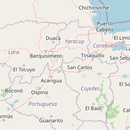
Map view of Cerro Saroche National Park

Use this park location map to pinpoint Cerro Saroche National Park in Venezuela, understand its exact geographic position, and read its mapped placement within the surrounding landscape more clearly.

Pigeon | © OpenStreetMap contributors

Location context for Cerro Saroche National Park

Lara State
Park atlas

Trace the regional spread of protected landscapes and semi-arid ecosystems across nearby Venezuelan geography.

Explore Related National Parks and Protected Areas Around Cerro Saroche National Park in Venezuela's Carora Depression
After exploring Cerro Saroche National Park's unique semi-arid ecosystems, browse other national parks and protected areas that share similar dryland landscapes in Venezuela. This regional park view enables geographic comparison, helping users understand the distribution of protected landscapes and their ecological context within the Carora Depression and broader Andean foothills.
National parkVenezuela

Terepaima National Park: Venezuela's National Park Protected Landscape

Mapped Boundaries and Regional Geography

Terepaima National Park is a designated national park within Venezuela, offering a clear focus for atlas-driven exploration of protected natural areas. This entry highlights the park's significance as a mapped protected landscape, providing essential geographic context and detail for understanding its boundaries and regional setting. It is an integral component for any structured discovery of Venezuela's conservation network.

Area
186.5 km²
Established
1976
IUCN
II
Relief
Mountain
National parkLara State

Yacambú National Park National Park: Protected Cloud Forest Landscape in Lara State

Mapped terrain and significant orchid diversity in Venezuela's Andean foothills.

Yacambú National Park is a significant national park in Venezuela's Lara State, protecting crucial humid cloud forest ecosystems in the Andean foothills. The park's terrain is defined by the mountainous topography of the Portuguesa Mountain Range, supporting a rich diversity of flora, including numerous orchid species. Its role in watershed protection for nearby regions underscores its importance as a conserved natural landscape with vital ecological functions.

Area
146 km²
Established
1962
IUCN
II
Relief
Mountain
National parkVenezuela

El Guache National Park: Venezuela's Protected Andean Foothill National Park

Map exploration of vital river basins and natural landscapes.

El Guache National Park is a protected national park in Venezuela, safeguarding the headwaters of five key rivers. Its landscape comprises mountainous terrain within the Andean foothills, crucial for watershed protection and regional biodiversity. This entry provides detailed geographic context, allowing for an atlas-style exploration of the park's mapped boundaries and its role as a vital protected area.

Area
122 km²
Established
1992
IUCN
II
Relief
Mountain
National parkVenezuela

Yurubí National Park: A National Park in Venezuela for Protected Landscape Exploration

Explore mapped boundaries and regional geography.

Yurubí National Park represents a distinct protected area within Venezuela, offering valuable data for geographic exploration and atlas-based understanding. This national park's identity is defined by its mapped boundaries and its role in the regional landscape context of northern South America. Delve into its protected territory to gain insights into Venezuela's natural geography and conservation landscapes.

Area
236.7 km²
Established
1960
IUCN
II
Relief
Mountain
National parkVenezuela

Dinira National Park: Protected Watershed and Andean Mountain Landscape

Explore its rugged terrain and páramo ecosystem.

Dinira National Park is a significant protected area in Venezuela, covering rugged Andean terrain vital for watershed protection. This national park features dramatic mountain landscapes, including the Humocaro Mountains and the Los Nepes páramo zone, supporting diverse cloud forest and high-altitude ecosystems. Understanding Dinira National Park offers insight into the geographic context of the Cordillera de Mérida and its hydrological importance.

Area
453.28 km²
Established
1988
IUCN
II
Relief
Mountain
National parkVenezuela

Morrocoy National Park: Venezuela's Coastal National Park with Distinct Protected Geography

Explore the mapped protected landscape and regional context.

Morrocoy National Park stands as a key protected area within Venezuela, offering a distinct focus for geographic exploration. As a national park, its mapped boundaries delineate a significant natural landscape critical for understanding regional conservation and the country's broader atlas of protected lands. Discover the unique geographic characteristics and the atlas-driven context of this important Venezuelan protected area.

Area
320.9 km²
Established
1974
IUCN
II
Relief
Mixed relief
National parkFalcón State

Médanos de Coro National Park: Venezuela's Unique Arid Landscape and Protected Dune System

Explore the mapped geography of this coastal desert in Falcón State.

Médanos de Coro National Park represents a remarkable protected area within Venezuela's Falcón State, renowned for its spectacular and active sand dune systems. This national park encompasses approximately 91 square kilometers of unique terrain, including large sand formations, salt marshes, and mangrove swamps, contributing to its designation as a key conservation site for arid coastal ecosystems. Users can explore the park's distinctive landscape, understand its geographic context, and discover the patterns of wind-sculpted dunes that define this Venezuelan national park.

Area
91 km²
Established
1974
IUCN
II
Relief
Lowland
National parkCarabobo

San Esteban National Park: Discover Carabobo's Protected Caribbean Forest Landscape

Mapped protected area and natural terrain in Venezuela.

San Esteban National Park represents a significant protected area within Venezuela's Carabobo region, offering a unique exploration of Caribbean forest ecosystems and historical cultural sites. Covering approximately 445 square kilometers, the park's terrain spans coastal areas to mountainous interiors, presenting a diverse natural landscape shaped by its position in the coastal mountain ranges. This national park is notable for its archaeological petroglyphs, colonial roads, and fortifications, providing a rich cultural heritage context alongside its natural ecosystems. Its status as a protected national park makes it a key destination for understanding the intersection of natural conservation and historical geography in Venezuela.

Area
445 km²
Established
1987
IUCN
II
Relief
Mixed relief

Common questions about visiting, size, designation, and location context for Cerro Saroche National Park

Cerro Saroche National Park FAQs for park facts, access, geography, and protected area context
Find quick answers about Cerro Saroche National Park, including protected-area facts, park geography, trail and visitor context, and how the park fits into its surrounding country and regional landscape.
MoriAtlas Explorer

Continue Your Protected Areas Search Across the Global Atlas

Deepen your exploration by continuing the structured search for national parks and protected areas worldwide. Utilize the comprehensive filtering capabilities to compare different conservation landscapes and refine your understanding of global park geography. Discover more about the distribution and characteristics of protected natural areas.

Global natural geography