

Mori Atlas logo
National parkChebera Churchura National Park

Discover the mapped boundaries and regional setting of Chebera Churchura National Park.

Chebera Churchura National Park: National Park Protected Landscape and Geographic Atlas

Chebera Churchura National Park stands as a significant national park within the South West Ethiopia Peoples' Region, offering a focal point for understanding Ethiopia's protected lands. This detailed page serves as an atlas entry, highlighting the park's geographic scope, its role as a protected landscape, and its mapped context within regional geography. Explore the identity of Chebera Churchura National Park as a key natural area for structured discovery.

National ParkElephant HabitatBirdwatchingCrater LakesRiver SystemsMontane Forest

Chebera Churchura National Park

National park

Park overview

Structured park overview, official facts, and landscape profile for Chebera Churchura National Park

Chebera Churchura National Park park facts, protected area profile, and essential visitor context
Review the core facts for Chebera Churchura National Park, including designation, size, terrain, visitor scale, habitats, and operating context in one park-focused overview.

About Chebera Churchura National Park

Chebera Churchura National Park represents one of Ethiopia's significant protected areas, established in 2006 in the South West Ethiopia Peoples' Region. The park occupies a strategic position in the Omo Gibe basin, spanning diverse terrain between the Dawro and Konta zones. The landscape features remarkable geological variety, with four small crater lakes scattered throughout the park and an extensive network of 49 perennial rivers that drain into the Omo River system. The Zinga River rises from the northeastern highlands and crosses the central part of the park, while the Shoshuma River flows from the northwestern highlands before joining the Zinga within the park boundaries. Natural caves, hot and cold springs such as Toshima and Nechwuha, and the Barbo waterfall add further ecological and scenic diversity to this protected area. The surrounding highlands contribute to the park's ecological significance by feeding its river systems and creating varied microclimates across the elevation gradient.

Quick facts and research context for Chebera Churchura National Park

Chebera Churchura National Park occupies 1250 square kilometers in the South West Ethiopia Peoples' Region of Ethiopia, positioned in the central Omo Gibe basin between the Dawro and Konta zones. The park was established in 2006, upgrading from its former status as the Kulo-Konta controlled hunting area. Elevation ranges from 500 to 2000 meters, creating diverse ecological zones. Annual rainfall between 1200 and 2300 millimeters supports rich vegetation, while temperatures range from 10 to 29 degrees Celsius. The wet season extends from March to September, with the dry season from December to February. Four crater lakes including Keriballa, Koka, and Shasho dot the landscape, along with 49 perennial rivers including the Zinga and Shoshuma, which drain into the Omo River.

Park context

Deeper park guide and search-rich context for Chebera Churchura National Park

Chebera Churchura National Park history, landscape, wildlife, and travel context
Explore Chebera Churchura National Park through its history, landscape character, ecosystems, wildlife, conservation priorities, cultural context, and seasonal travel timing in a structured park guide built for atlas discovery and search intent.

Why Chebera Churchura National Park stands out

Chebera Churchura National Park is best known for its substantial African elephant population, with over 500 individuals roaming the park in different herds, making it one of the most significant elephant habitats in Ethiopia. The park also stands out for its exceptional bird diversity, with 237 recorded species including five that are endemic to Ethiopia: the white-winged cliff chat, banded barbet, wattled ibis, Ethiopian oriole, and thick-billed raven. The combination of crater lakes, river systems, waterfalls, and hot and cold springs creates a visually diverse landscape that supports remarkable biodiversity across multiple habitat types.

Chebera Churchura National Park history and protected-area timeline

The area that now comprises Chebera Churchura National Park was originally designated as the Kulo-Konta controlled hunting area, primarily used for elephant hunting before its elevation to national park status. In 2005, the regional government of what was then the Southern Nations, Nationalities, and Peoples' Region upgraded the protected area to national park status, with formal establishment following in 2006. The transformation from a hunting area to a fully protected national park reflected growing recognition of the region's ecological significance and the need to preserve its wildlife populations, particularly the elephant herds that had historically been targeted by hunting activities. The Office of Culture Sport and Tourism now manages the park, continuing efforts to balance conservation with sustainable regional development.

Chebera Churchura National Park landscape and geographic character

The park's physical landscape encompasses a remarkable range of elevations from 500 to 2000 meters above sea level, creating distinct ecological zones across its 1250 square kilometer extent. Four crater lakes, namely Keriballa, Koka, and Shasho, punctuate the terrain, each contributing to the park's visual and ecological diversity. The extensive river network of 49 perennial streams includes the Zinga and Shoshuma, which flow through the park and connect to the broader Omo River system. Natural caves add geological interest to the landscape, while hot and cold springs such as Toshima and Nechwuha emerge at various points. The Barbo waterfall provides a striking natural feature within the park. This combination of crater lakes, river valleys, waterfalls, caves, and springs creates a varied topography that supports the diverse habitats found within the protected area.

Chebera Churchura National Park ecosystems, habitats, and plant life

Chebera Churchura National Park supports four primary habitat types that together create a rich ecological mosaic. Wooded grassland dominates approximately 62 percent of the park, characterized by extensive elephant grass savanna. Montane woodland covers about 29 percent of the area, while woodland and riparian forest comprise the remaining habitat. Palm trees represent a particularly diverse element of the park's flora, while dominant woody species include Ficus, Combretum, Ehretia, and Albizia. The park harbors significant non-timber forest products including Enset, Coffee, Coriander, and various Piper species that support local economies. Of the 106 woody plant species identified in the park, six are endemic to Ethiopia, highlighting the region's botanical significance. The annual rainfall of 1200 to 2300 millimeters, concentrated during the wet season from March to September, sustains these diverse vegetation communities across the elevation gradient.

Chebera Churchura National Park wildlife and species highlights

The park supports impressive wildlife diversity with 37 species of large mammals recorded within its boundaries. The African elephant population numbers over 500 individuals that move through the park in different herds, representing one of the most significant elephant populations in Ethiopian protected areas. Carnivores present include lions, leopards, and servals, while the park also supports populations of greater kudus, colobus monkeys, vervet monkeys, hippopotamuses, defassa waterbucks, warthogs, and Cape buffalos. The avian fauna is exceptionally diverse with 237 bird species documented. Of particular conservation significance, five bird species endemic to Ethiopia occur here: the white-winged cliff chat, banded barbet, wattled ibis, Ethiopian oriole, and thick-billed raven. This combination of large mammals and diverse birdlife makes Chebera Churchura one of Ethiopia's most biodiversity-rich protected areas.

Chebera Churchura National Park conservation status and protection priorities

Chebera Churchura National Park plays a crucial conservation role in Ethiopia as a protected area supporting substantial populations of threatened species, particularly the African elephant. The park's designation as IUCN Category II reflects its primary function as a national park dedicated to ecosystem conservation and protection. The presence of over 500 elephants within the park makes it strategically important for elephant conservation in Ethiopia, as the species faces pressure from habitat loss and human-wildlife conflict in many parts of its range. The protection of endemic bird species including five Ethiopian endemics adds further conservation significance, while the diverse habitats from lowland grasslands to montane forest create a conservation mosaic that supports multiple species assemblages. The network of rivers draining to the Omo River system also positions the park as important for broader watershed conservation in the region.

Chebera Churchura National Park cultural meaning and human context

The park lies within the territory of the Dawro and Konta peoples in the South West Ethiopia Peoples' Region, areas known for their rich cultural traditions and agricultural practices. The local communities have historically interacted with the landscape that now falls within the park boundaries, with the area originally designated for controlled hunting before its protection as a national park. The park's infrastructure including the Chebera Safari Lodge indicates the integration of conservation with regional tourism development, supporting local economies while preserving the natural environment.

Top sights and standout views in Chebera Churchura National Park

Chebera Churchura National Park offers distinctive features that set it apart among Ethiopian protected areas. The over 500 African elephants represent one of the strongest elephant populations in the country, visible across the park's grasslands and woodlands. The crater lakes including Keriballa, Koka, and Shasho provide scenic beauty and ecological diversity, while the Barbo waterfall offers a dramatic natural spectacle. The extensive river network of 49 perennial streams creates varied habitats throughout the park, with the Zinga and Shoshuma rivers offering scenic value and supporting riparian ecosystems. Five endemic Ethiopian bird species add particular ornithological significance, making the park a destination of interest for birdwatchers. The combination of hot and cold springs, natural caves, and varied elevation from 500 to 2000 meters creates a landscape of considerable geographical interest.

Best time to visit Chebera Churchura National Park

The optimal time to visit Chebera Churchura National Park coincides with the dry season from December to February, when reduced vegetation density improves wildlife visibility and access to water sources concentrates animals near rivers and lakes. The cooler temperatures during these months, particularly in the higher elevations, make for more comfortable exploration. However, the wet season from March to September brings lush green landscapes and flowing waterfalls, with the park's vegetation at its most verdant. The annual rainfall ranging from 1200 to 2300 millimeters substantially affects the park's appearance and accessibility, with some roads becoming difficult during peak rainy months. Visitors interested in birdwatching may find the wet season rewarding as migratory species arrive and resident birds are active.
Park location guide

Geography guide, regional context, and park location map for Chebera Churchura National Park

Chebera Churchura National Park park geography, regions, and map view in Ethiopia
Understand where Chebera Churchura National Park sits in Ethiopia through a broader geographic reading of the surrounding landscape, nearby location context, and its mapped position within the national park landscape.

How Chebera Churchura National Park fits into Ethiopia

Ethiopia is a landlocked federal parliamentary republic located in the Horn of Africa. With a population of approximately 135 million people, it is the 14th-most populous country in the world and the most populous landlocked country. The country is known for its ancient history, diverse ethnic groups, and the capital Addis Ababa, which lies near the East African Rift.

Wider geography shaping Chebera Churchura National Park in Ethiopia

Ethiopia is located in the Horn of Africa, bordered by Eritrea to the north, Djibouti to the northeast, Somalia to the east, Kenya to the south, South Sudan to the west, and Sudan to the northwest. The country sits on the African and Somali tectonic plates, with the East African Rift running through it. The terrain includes highlands, valleys, and lowlands.

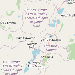
Map view of Chebera Churchura National Park

Use this park location map to pinpoint Chebera Churchura National Park in Ethiopia, understand its exact geographic position, and read its mapped placement within the surrounding landscape more clearly.

Pigeon | © OpenStreetMap contributors

Location context for Chebera Churchura National Park

South West Ethiopia Peoples' Region
Park atlas

Compare similar protected landscapes and their geographic spread across the surrounding region of Ethiopia.

Explore Related Protected Areas and National Parks Near Chebera Churchura National Park
Explore national parks and protected areas near Chebera Churchura National Park, identifying their unique landscapes and conservation features. This view provides essential regional context, allowing users to compare diverse protected geographies and their unique conservation values within Ethiopia.
National parkEthiopia

Maze National Park: Ethiopia's Essential National Park for Swayne's Hartebeest and Geothermal Wonders

Discover mapped savanna ecosystems and unique montane geography within this protected Ethiopian landscape.

Maze National Park represents a significant protected area within Ethiopia, vital for the conservation of the endangered Swayne's hartebeest. Its diverse terrain includes savanna grasslands and unique geothermal features such as active geysers, all set against a distinctive montane backdrop. This national park offers a deep dive into Ethiopia's natural heritage, providing a clear geographic identity and valuable context for landscape exploration.

Area
210 km²
Established
2005
IUCN
II
Relief
Mixed relief
National parkEthiopia

Omo National Park: Ethiopia's Remote Protected Landscape with Rich Wildlife Spectacles

Mapped boundaries, savannah plains, and Maji Mountains terrain.

Omo National Park is a remote protected area in Ethiopia renowned for its expansive savannah, riverine woodlands, and remarkable wildlife concentrations. Covering over 4,000 square kilometers, this national park presents a landscape of sweeping plains, the vital Omo River corridor, and the dramatic Maji Mountains. The park's protected status safeguards exceptional populations of large mammals, offering a glimpse into an untamed African wilderness. Explore the mapped geography and the unique ecological zones that contribute to its significant conservation value.

Area
4,068 km²
Established
1980
IUCN
II
Relief
Mixed relief
National parkSouth Ethiopia Regional State

Nechisar National Park: Protected Natural Landscape in South Ethiopia Regional State

Explore the mapped geography and protected area context of this Ethiopian park.

Nechisar National Park is designated as a national park, serving as a critical protected natural area within the South Ethiopia Regional State. This MoriAtlas entry provides detailed geographic context, focusing on the park's mapped boundaries and its place within the regional landscape. Users can explore the park's identity as a protected territory, offering a foundation for understanding Ethiopia's natural protected areas through a geographic lens.

Area
1,030 km²
Established
1974
IUCN
II
Relief
Mixed relief
National parkSouth Ethiopia Regional State

Mago National Park: Protected Savanna and Riverine Ecosystems in South Ethiopia

Discover the unique landscapes and wildlife habitats mapped within this national park.

Mago National Park stands as a critical protected landscape within the South Ethiopia Regional State, characterized by its significant riverine forests, acacia savanna, and wetland environments along the Mago and Omo rivers. This national park is integral for understanding the distribution of wildlife and the geographic context of Ethiopia's natural heritage. Its mapped terrain offers insights into a landscape that supports both diverse ecosystems and unique cultural traditions, making it a vital component of the country's conservation network.

Area
2,220 km²
Established
1979
IUCN
II
Relief
Mixed relief
National parkEthiopia

Didessa National Park: Protected River Valley Landscape in Ethiopia's Western Highlands

Discover dramatic escarpments, forested terrain, and waterfalls.

Explore Didessa National Park, a protected area in western Ethiopia notable for its dramatic topographical features. This national park showcases a striking landscape of steep escarpments flanking the Didessa River valley, supporting lush forest ecosystems. Key features include numerous waterfalls that contribute to the park's distinctive terrain and ecological significance. Understanding Didessa National Park offers insight into Ethiopia's protected lands and their unique geographic attributes.

Area
1,300 km²
Established
2017
IUCN
II
Relief
Lowland
National parkOromia Region

Abijatta-Shalla National Park: Protected National Park within Oromia Region

Mapped landscape and regional geographic context.

Delve into the protected landscape identity of Abijatta-Shalla National Park, a designated national park situated within the Oromia Region. This dedicated detail page offers an atlas-driven perspective, focusing on the park's geographic scope, mapped terrain, and its significance as a protected natural area. Understand its role in the broader context of Ethiopian protected lands and regional geography.

Area
887 km²
Established
1974
IUCN
II
Relief
Mountain
National parkArsi Zone

Arsi Mountains National Park: Protected Ethiopian Highlands Landscape & Geography

Mapped protected terrain and endemic species habitat within the Arsi Zone.

Arsi Mountains National Park is a vast protected area celebrated for its significant biodiversity and distinctive Afro-alpine ecosystems. Situated in the Arsi Zone, this national park encompasses a dramatic mountain landscape central to the Ethiopian Highlands. It serves as a crucial refuge for endangered endemic species, including the mountain nyala and Ethiopian wolf, within its varied ecological zones and protected park boundaries, offering rich context for geographic exploration.

Area
10,876 km²
Established
2011
IUCN
II
Relief
Mountain
National parkSouth Sudan

Boma National Park: Protected Landscape in South Sudan's East African Geography

Explore mapped boundaries and regional terrain context.

Boma National Park represents a vital protected landscape within South Sudan. As a national park, it contributes significantly to the geographic understanding of conservation areas in East Africa. Its distinct location and mapped outlines provide essential context for those exploring the regional atlas, highlighting its importance in understanding South Sudan's natural terrain and protected area network.

Area
22,800 km²
Established
1977
IUCN
II
Relief
Lowland

Common questions about visiting, size, designation, and location context for Chebera Churchura National Park

Chebera Churchura National Park FAQs for park facts, access, geography, and protected area context
Find quick answers about Chebera Churchura National Park, including protected-area facts, park geography, trail and visitor context, and how the park fits into its surrounding country and regional landscape.
MoriAtlas Explorer

Continue Your Protected Areas Search Across the Global Atlas

Deepen your exploration by continuing the structured search for national parks and protected areas worldwide. Utilize the comprehensive filtering capabilities to compare different conservation landscapes and refine your understanding of global park geography. Discover more about the distribution and characteristics of protected natural areas.

Global natural geography