

Mori Atlas logo
National parkAbijatta-Shalla National Park

Explore the mapped boundaries and regional context of this national park in Oromia.

Abijatta-Shalla National Park: Protected Landscape and Geographic Atlas

Abijatta-Shalla National Park stands as a significant protected area within the Oromia Region of Ethiopia, offering a distinct chapter in geographic discovery. This entry provides a focused view of its mapped boundaries and landscape context, essential for understanding its place within the broader atlas of protected lands. Dive into the details that define Abijatta-Shalla National Park as a key natural landscape, contributing to the regional geography.

Rift Valley lakesFlamingo habitatAlkaline lakesHot springsEthiopian HighlandsBirdwatching

Abijatta-Shalla National Park

National park

Park overview

Structured park overview, official facts, and landscape profile for Abijatta-Shalla National Park

Abijatta-Shalla National Park park facts, protected area profile, and essential visitor context
Review the core facts for Abijatta-Shalla National Park, including designation, size, terrain, visitor scale, habitats, and operating context in one park-focused overview.

About Abijatta-Shalla National Park

Abijatta-Shalla National Park represents one of Ethiopia's notable protected areas, established to conserve the unique Rift Valley lake ecosystem and surrounding landscapes in the central Ethiopian highlands. The park's defining feature is the pair of alkaline lakes, Abijatta and Shalla, which sit within a volcanic landscape shaped by the O'a Caldera and associated tectonic activity. These lakes differ substantially in character: Lake Abijatta features a thin crust of dried mud that can pose risks to unwary visitors, while Lake Shalla supports rich hot springs along its southwestern and eastern shores.

The park lies approximately 200 kilometers south of Addis Ababa, accessible via the highway connecting Batu and Shashamane. This positioning places it within the broader Rift Valley lakes region, an area of significant ecological and geological importance in East Africa. The park's altitudinal range, from 1540 to 2075 meters, creates diverse microclimates and habitat conditions that support the mix of highland and lowland species found within its boundaries.

Visitor attractions within the park include viewpoints overlooking the lakes, bird-watching opportunities, and photography. The landscape offers trekking possibilities, particularly around Mount Fike where visitors can gain elevated perspectives across the lake system. However, the park faces substantial conservation challenges, with habitat degradation from human settlement and charcoal production reducing the quality of available wildlife habitat.

Quick facts and research context for Abijatta-Shalla National Park

Abijatta-Shalla National Park spans 887 square kilometers in the Ethiopian Rift Valley, protecting a dual-lake ecosystem centered on Lake Abijatta and Lake Shalla. The park sits at elevations between 1540 and 2075 meters, with Mount Fike as the highest point. Established in 1974 and managed by the Ethiopian Wildlife Conservation Authority, the park lies 200 kilometers south of Addis Ababa near the town of Shashamane. The two lakes are separated by three kilometers of hilly terrain and were formed through volcanic activity associated with the O'a Caldera. The park features hot springs on the northeastern shore of Lake Abijatta and along the southwestern and eastern shores of Lake Shalla.

Park context

Deeper park guide and search-rich context for Abijatta-Shalla National Park

Abijatta-Shalla National Park history, landscape, wildlife, and travel context
Explore Abijatta-Shalla National Park through its history, landscape character, ecosystems, wildlife, conservation priorities, cultural context, and seasonal travel timing in a structured park guide built for atlas discovery and search intent.

Why Abijatta-Shalla National Park stands out

Abijatta-Shalla National Park is best known for its spectacular flamingo populations that congregate on the alkaline waters of Lake Abijatta and Lake Shalla. The park's two major lakes are among the most significant saline lake ecosystems in the Ethiopian Rift Valley, supporting dense populations of both greater and lesser flamingos that feed on the blue-green algae abundant in these nutrient-rich waters. The presence of hot springs, particularly on the northeastern corner of Lake Abijatta and along Shalla's shores, adds another distinctive feature to the park's landscape. Mount Fike, rising between the two lakes, provides a notable viewpoint offering perspectives across the dual-lake system and the broader Rift Valley environment.

Abijatta-Shalla National Park history and protected-area timeline

Abijatta-Shalla National Park was established in 1974 as part of Ethiopia's broader effort to designate protected areas that conserve the country's diverse ecosystems and wildlife populations. The park was created with the intention of protecting the significant bird populations associated with the Rift Valley lakes and preserving the surrounding woodland and grassland habitats.

Following its establishment, the park experienced significant pressures during the final period of the Derg regime and the subsequent political instability in Ethiopia. During this tumultuous phase, central authority weakened considerably, and large numbers of nomads moved into the park area with their livestock, establishing residence within what had been designated protected habitat. This influx of pastoralists and their animals placed substantial pressure on the park's ecological integrity.

Rehabilitation efforts were initiated in 1996, with plans announced for actively integrating local communities in the future planning and development of the park. These efforts aimed to address both the conservation deficits that had developed and the human dimensions of park management. Despite these initiatives, challenges related to habitat degradation and human-wildlife conflict have continued to affect the park's ecological condition.

Abijatta-Shalla National Park landscape and geographic character

The landscape of Abijatta-Shalla National Park is defined by its two central alkaline lakes set within a volcanic terrain of the Ethiopian Rift Valley. Lake Abijatta and Lake Shalla lie approximately three kilometers apart, separated by a corridor of hilly land. Both lakes owe their existence to the volcanic processes associated with the O'a Caldera, which created the basin-like depressions that now hold these saline waters.

Mount Fike, the park's highest peak at 2075 meters, rises between the two lakes and provides an anchoring topographic feature for the landscape. The terrain surrounding the lakes includes hilly ground that breaks the otherwise relatively flat lake margins, creating opportunities for elevated viewpoints. The elevation range across the park spans from 1540 meters at the lake surfaces to 2075 meters at Mount Fike's summit.

Hot springs represent an important landscape feature, particularly along the northeastern corner of Lake Abijatta and on the southwestern and eastern shores of Lake Shalla. These geothermal features contribute to the lakes' alkaline chemistry and provide unique habitats within the broader park ecosystem. Lake Chitu, a smaller saline lake situated south of Lake Shalla, adds another water body to the park's landscape mosaic.

Abijatta-Shalla National Park ecosystems, habitats, and plant life

The ecological character of Abijatta-Shalla encompasses a complex of habitats tied to the Rift Valley lake environment and surrounding highlands. The park contains open grasslands, dry savannas, arid shrublands, and deciduous woodland, creating a mosaic of vegetation types that support diverse wildlife communities. The savanna woodlands are dominated by acacia species, including umbrella thorn acacia, red acacia, and gum acacia, alongside Egyptian balsam and sycamore figs.

The alkaline lake environment represents the park's most distinctive ecological zone. These shallow, saline waters support abundant growth of blue-green algae that form the base of the food chain for the park's renowned flamingo populations. The lakes function as critical habitat for both greater and lesser flamingos, providing feeding grounds and breeding areas. Lake Shalla additionally serves as a breeding site for great white pelicans and various stork, heron, egret, and cormorant species.

The surrounding terrestrial habitats support mammals adapted to semi-arid conditions, while the broader region's position along the Rift Valley flyway makes it significant for migratory bird species. The park's elevation gradient and varied topography create environmental heterogeneity that supports both highland and lowland species assemblages.

Abijatta-Shalla National Park wildlife and species highlights

Abijatta-Shalla National Park supports remarkable faunal diversity, with 76 mammal species and over 300 bird species recorded within its boundaries. The mammal community includes Grant's gazelles, bohor reedbucks, oribis, common warthogs, greater kudus, caracals, honey badgers, colobus monkeys, aardvarks, spotted hyenas, klipspringers, porcupines, olive baboons, and black-backed jackals. Several species endemic to the Ethiopian highlands occur within the park, including Scott's hairy bat, white-toothed shrew, Mahomet mouse, Ethiopian white-footed mouse, Abyssinian grass rat, and Harrington's rat.

The avifauna represents one of the park's most significant wildlife assets. Both greater and lesser flamingos occur in substantial numbers on Lake Abijatta, Lake Shalla, and the smaller Lake Chitu, using these alkaline waters for feeding and breeding. Great white pelicans nest on Lake Shalla, while the surrounding wetlands support diverse assemblages of storks, herons, egrets, plovers, and cormorants. Endemic Ethiopian species such as wattled ibis and yellow-fronted parrot occur within the park, alongside near-endemic species including black-winged lovebird, white-winged cliff chat, and white-billed starling.

However, the park has experienced significant wildlife population declines. Species once abundant including lions, giraffes, waterbucks, buffalos, and Swayne's hartebeests have been locally extirpated, likely due to hunting pressure and habitat loss. Current observations suggest that while viable populations of greater kudu, Grant's gazelle, black-backed jackal, and spotted hyena may persist, evidence of these populations is limited. Introduced livestock now substantially outnumber native wildlife in many areas.

Abijatta-Shalla National Park conservation status and protection priorities

Abijatta-Shalla National Park faces significant conservation challenges that have substantially diminished its wildlife populations from historical levels. The park was established with the explicit goal of protecting wildlife, yet the reality of conservation on the ground has proven difficult. During the instability surrounding the fall of the Derg regime, nomads exploited weakened central authority to move into the park with their livestock, establishing permanent settlement within protected lands.

The woodland surrounding Lake Abijatta has suffered extensive degradation through charcoal production, with large areas of acacia forest cleared for fuel. Beyond tree removal, some local communities have extracted salty soil from the lake shoreline for commercial sale, further altering the lake margin habitat. The continued presence of pastoralists and their cattle within the park has created conditions where livestock outnumber native wildlife, and the thin crust of dried mud on Lake Abijatta's surface poses physical hazards.

Despite these challenges, the park retains substantial conservation value. Over 300 bird species have been recorded in the area, and the alkaline lake ecosystem continues to support significant flamingo populations. Rehabilitation efforts initiated in 1996 have sought to address these issues, with community integration identified as a key strategy for sustainable park management. The park's location within the Rift Valley system and its representation of highland lake ecosystems remain important for regional biodiversity conservation.

Abijatta-Shalla National Park cultural meaning and human context

Abijatta-Shalla National Park does not have extensive documented cultural context in available sources. The park's landscape has been shaped by geological processes rather than long-term human settlement, and the alkaline lake environment was not conducive to traditional agriculture. The primary human interaction with the area historically involved pastoralist communities utilizing the surrounding lands for grazing.

The establishment of the park in 1974 created formal protected status that conflicted with existing pastoral land use patterns. The period of political instability during the late Derg era saw increased nomad settlement within park boundaries, reflecting broader patterns of displacement and migration in the Ethiopian highlands. Current conservation planning emphasizes community integration, acknowledging that sustainable park management must address the human populations whose livelihoods intersect with protected lands.

Top sights and standout views in Abijatta-Shalla National Park

Abijatta-Shalla National Park offers visitors the opportunity to experience one of Ethiopia's most significant Rift Valley lake ecosystems. The sight of hundreds of greater and lesser flamingos wading in the alkaline waters of Lake Abijatta and Lake Shalla represents the park's most iconic wildlife spectacle. Hot springs along the lake margins create unique atmospheric conditions and provide interesting landscape features. Mount Fike offers trekking opportunities with panoramic views spanning both major lakes and extending to Lake Langano in the distance.

The park provides important bird-watching opportunities, with over 300 species recorded including endemic and near-endemic Ethiopian species. The dual-lake system, with its contrasting characters and the hilly terrain between them, creates a varied landscape for exploration. Despite conservation challenges, the park retains meaningful wildlife populations and continues to function as a protected area within Ethiopia's national park system.

Best time to visit Abijatta-Shalla National Park

The best time to visit Abijatta-Shalla National Park generally corresponds to the dry season months from October through March, when conditions are most favorable for wildlife viewing and outdoor exploration. During this period, reduced rainfall creates clearer visibility across the landscape and makes roads more accessible. The dry season also concentrates wildlife around remaining water sources, potentially facilitating observations.

The park can be visited year-round, though the short rainy season from June to September brings increased vegetation and higher humidity that may affect visibility and comfort. Bird activity remains substantial throughout the year, with flamingos present on the lakes consistently. Visitors should exercise caution around Lake Abijatta's shoreline due to the unstable nature of the dried mud crust.
Park location guide

Geography guide, regional context, and park location map for Abijatta-Shalla National Park

Abijatta-Shalla National Park park geography, regions, and map view in Ethiopia
Understand where Abijatta-Shalla National Park sits in Ethiopia through a broader geographic reading of the surrounding landscape, nearby location context, and its mapped position within the national park landscape.

How Abijatta-Shalla National Park fits into Ethiopia

Ethiopia is a landlocked federal parliamentary republic located in the Horn of Africa. With a population of approximately 135 million people, it is the 14th-most populous country in the world and the most populous landlocked country. The country is known for its ancient history, diverse ethnic groups, and the capital Addis Ababa, which lies near the East African Rift.

Wider geography shaping Abijatta-Shalla National Park in Ethiopia

Ethiopia is located in the Horn of Africa, bordered by Eritrea to the north, Djibouti to the northeast, Somalia to the east, Kenya to the south, South Sudan to the west, and Sudan to the northwest. The country sits on the African and Somali tectonic plates, with the East African Rift running through it. The terrain includes highlands, valleys, and lowlands.

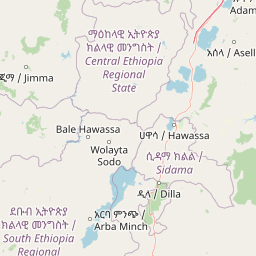
Map view of Abijatta-Shalla National Park

Use this park location map to pinpoint Abijatta-Shalla National Park in Ethiopia, understand its exact geographic position, and read its mapped placement within the surrounding landscape more clearly.

Pigeon | © OpenStreetMap contributors

Location context for Abijatta-Shalla National Park

Oromia Region
Park atlas

Compare the volcanic Rift Valley landscapes and diverse protected areas across Ethiopia, mapping regional park geography.

Explore Nearby National Parks and Protected Areas Beyond Abijatta-Shalla National Park
Browse national parks and protected areas near Abijatta-Shalla National Park, exploring other Rift Valley ecosystems and diverse Ethiopian landscapes. Comparing these adjacent conservation sites offers valuable geographic context, revealing the broader spread of protected-area types and regional terrain.
National parkArsi Zone

Arsi Mountains National Park: Protected Ethiopian Highlands Landscape & Geography

Mapped protected terrain and endemic species habitat within the Arsi Zone.

Arsi Mountains National Park is a vast protected area celebrated for its significant biodiversity and distinctive Afro-alpine ecosystems. Situated in the Arsi Zone, this national park encompasses a dramatic mountain landscape central to the Ethiopian Highlands. It serves as a crucial refuge for endangered endemic species, including the mountain nyala and Ethiopian wolf, within its varied ecological zones and protected park boundaries, offering rich context for geographic exploration.

Area
10,876 km²
Established
2011
IUCN
II
Relief
Mountain
National parkBale Zone

Bale Mountains National Park National Park: Explore Protected Landscape and Regional Geography

Mapped boundaries and natural terrain context for this Ethiopian park.

Delve into Bale Mountains National Park, a designated national park in Ethiopia's Bale Zone, focusing on its role as a vital protected landscape. This page offers detailed insights into the park's mapped boundaries and its contribution to the regional geography, providing a foundation for structured atlas exploration of protected areas and natural terrain. Understand the geographic significance and landscape identity of this key conservation entity within the broader context of Ethiopia's natural heritage.

Area
2,220 km²
Established
1970
IUCN
II
Relief
Mountain
National parkEthiopia

Maze National Park: Ethiopia's Essential National Park for Swayne's Hartebeest and Geothermal Wonders

Discover mapped savanna ecosystems and unique montane geography within this protected Ethiopian landscape.

Maze National Park represents a significant protected area within Ethiopia, vital for the conservation of the endangered Swayne's hartebeest. Its diverse terrain includes savanna grasslands and unique geothermal features such as active geysers, all set against a distinctive montane backdrop. This national park offers a deep dive into Ethiopia's natural heritage, providing a clear geographic identity and valuable context for landscape exploration.

Area
210 km²
Established
2005
IUCN
II
Relief
Mixed relief
National parkSouth Ethiopia Regional State

Nechisar National Park: Protected Natural Landscape in South Ethiopia Regional State

Explore the mapped geography and protected area context of this Ethiopian park.

Nechisar National Park is designated as a national park, serving as a critical protected natural area within the South Ethiopia Regional State. This MoriAtlas entry provides detailed geographic context, focusing on the park's mapped boundaries and its place within the regional landscape. Users can explore the park's identity as a protected territory, offering a foundation for understanding Ethiopia's natural protected areas through a geographic lens.

Area
1,030 km²
Established
1974
IUCN
II
Relief
Mixed relief
National parkSouth West Ethiopia Peoples' Region

Chebera Churchura National Park: Ethiopia's National Park Protected Landscape Explorer

Mapping the protected area and regional geography of Chebera Churchura.

Chebera Churchura National Park is a key protected landscape in the South West Ethiopia Peoples' Region, designated as a national park. This page provides detailed geographic context and atlas-level information about the park's boundaries and its place within the regional terrain. Engage with the structured data that defines Chebera Churchura National Park's identity as a significant natural area for map-based discovery.

Area
1,250 km²
Established
2006
IUCN
II
Climate
Tropical
National parkEthiopia

Awash National Park: Mapped Protected Boundaries and Ethiopian Regional Geography

Discover the protected landscape of this Ethiopian National Park.

Awash National Park represents a significant protected area within Ethiopia, offering a rich focus for geographic discovery. This page illuminates the park's specific mapped boundaries and its positioning within the surrounding regional geography. It serves as a detailed entry point for understanding the park's landscape character and its role as a national park in East Africa.

Area
850 km²
Established
1966
IUCN
II
Relief
Mixed relief
National parkEthiopia

Didessa National Park: Protected River Valley Landscape in Ethiopia's Western Highlands

Discover dramatic escarpments, forested terrain, and waterfalls.

Explore Didessa National Park, a protected area in western Ethiopia notable for its dramatic topographical features. This national park showcases a striking landscape of steep escarpments flanking the Didessa River valley, supporting lush forest ecosystems. Key features include numerous waterfalls that contribute to the park's distinctive terrain and ecological significance. Understanding Didessa National Park offers insight into Ethiopia's protected lands and their unique geographic attributes.

Area
1,300 km²
Established
2017
IUCN
II
Relief
Lowland
National parkSouth Ethiopia Regional State

Mago National Park: Protected Savanna and Riverine Ecosystems in South Ethiopia

Discover the unique landscapes and wildlife habitats mapped within this national park.

Mago National Park stands as a critical protected landscape within the South Ethiopia Regional State, characterized by its significant riverine forests, acacia savanna, and wetland environments along the Mago and Omo rivers. This national park is integral for understanding the distribution of wildlife and the geographic context of Ethiopia's natural heritage. Its mapped terrain offers insights into a landscape that supports both diverse ecosystems and unique cultural traditions, making it a vital component of the country's conservation network.

Area
2,220 km²
Established
1979
IUCN
II
Relief
Mixed relief

Common questions about visiting, size, designation, and location context for Abijatta-Shalla National Park

Abijatta-Shalla National Park FAQs for park facts, access, geography, and protected area context
Find quick answers about Abijatta-Shalla National Park, including protected-area facts, park geography, trail and visitor context, and how the park fits into its surrounding country and regional landscape.
MoriAtlas Explorer

Continue Your Protected Areas Search Across the Global Atlas

Deepen your exploration by continuing the structured search for national parks and protected areas worldwide. Utilize the comprehensive filtering capabilities to compare different conservation landscapes and refine your understanding of global park geography. Discover more about the distribution and characteristics of protected natural areas.

Global natural geography