Why Chipping Norton Islands stands out
The Chipping Norton Islands are best known for being a man-made lake island system that has become an unexpected haven for native birdlife and woodland habitats in heavily urbanized western Sydney. Their most distinctive feature is the way four small islets, originally part of the Georges River floodplain, now function as a refuge where over fifty species of birds can feed, roost, and breed amid remnant native vegetation. The islands are also notable for their layered heritage, including their connection to early colonial land grants, their name drawn from the Darug people of the Sydney region, and the Bulba-Gong name derived from the Eora language. The combination of engineered lake creation and surviving floodplain woodland gives the area an unusual mixture of cultural, ecological, and geological significance.
Chipping Norton Islands history and protected-area timeline
The land that now forms the Chipping Norton Islands was once part of a continuous strip of country on the right bank of the Georges River in what is now western Sydney. During the early colonial period, grants of land in this stretch of the river were made to figures including Thomas Rowley and George Johnston, both of them associated with the early British presence in New South Wales. Further upstream, Thomas Moore, an early settler and carpenter for the colony, established farmland along the river, shaping the early European land use of the district.
In the late 1970s, the character of the area changed significantly. A working sand mine in what is now Chipping Norton Lake was deliberately flooded, and the rising water submerged the surrounding lowlands. Because the four islands stood slightly higher than the rest of the terrain, they remained above water as isolated islets, creating the present-day lake-and-island landscape. Although the lake is therefore a relatively recent feature, the islands themselves carry older layers of place naming and local Aboriginal heritage, including references to the Darug people and the Eora language.
Chipping Norton Islands landscape and geographic character
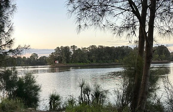
The Chipping Norton Islands sit within Chipping Norton Lake, a broad sheet of water that occupies what was once a sand quarry in the floodplain of the Georges River. The surrounding terrain is low-lying and typical of western Sydney's riverine flats, with the highest point on the islands reaching only about thirteen metres above sea level. The lake is bordered by the suburbs of Chipping Norton, Lansvale, and Cabramatta, giving it an unusually suburban setting.
The islands themselves are small and varied in shape. Bass Island lies toward the western end of the lake near Cabramatta. Bulba-Gong, the largest of the four, is found in the eastern part of the lake within Chipping Norton. Crescent Island is a narrow, strip-shaped islet in the northwest, while Daruk Island lies near the centre of the lake and is the most distant from the shore, although still within the bounds of Chipping Norton. Together they form a compact, low-relief archipelago that contrasts sharply with the dense urban development that surrounds the lake.
Chipping Norton Islands ecosystems, habitats, and plant life
The islands and the surrounding lake make up one of the more ecologically meaningful patches of habitat in inner western Sydney. The woodland fringes of the lake include sedgelands, reed beds, and mangrove communities, backed by native trees such as swamp oak, forest red gum, blue box, grey box, bangalay, and rough-barked apple. These vegetation types reflect the natural patterns of the Georges River floodplain and give the islands a character that is quite different from the surrounding suburbs.
A particular feature of the site is its alluvial woodland vegetation, which is recognised as an endangered ecological community. The survival of these floodplain woodland elements within a man-made lake is striking and gives the islands considerable conservation value. Open water, wet margins, reed beds, and woodland patches interact across a small area, producing a varied mosaic that supports a wide range of bird species and other wildlife.
Chipping Norton Islands wildlife and species highlights
The Chipping Norton Islands are most notable for the richness of birdlife that uses the lake, the islands, and their fringing habitats. More than fifty different kinds of birds have been recorded in the area, either visiting or settling on the islands themselves. Species observed include Australian pelicans, Australasian swamphens, egrets, maned ducks, Pacific black ducks, sacred ibis, and pardalote, among many others. The combination of open water, reeds, mangroves, and woodland produces habitat conditions that can support both waterbirds and woodland birds in close proximity.
The wider waters around the islands also harbour more mobile marine life. Dolphins and sharks are reported in the surrounding waters of the lake and the connected reaches of the Georges River. Because the islands are unpopulated and largely closed to casual visitors, they function as a relatively undisturbed refuge, allowing wildlife to roost, feed, and breed with less pressure than in most other parts of western Sydney.
Chipping Norton Islands conservation status and protection priorities
The Chipping Norton Islands carry conservation significance well beyond their small physical footprint. Their presence within an artificial lake in the middle of a heavily urbanized region gives them an outsized ecological role. They function as a refuge for native birdlife and as a refuge for floodplain vegetation that is otherwise under threat across the wider Sydney region.
A key element of this conservation value is the alluvial woodland community that survives around the lake, which is officially recognised as an endangered ecological community. The mix of sedgelands, reeds, mangroves, and native trees such as swamp oak and forest red gum reflects the original character of the Georges River floodplain and is therefore of considerable interest for habitat preservation. The islands' protected status, their prohibition on casual visitor access, and the absence of permanent human settlement help preserve these qualities in an otherwise densely developed part of Sydney.
Chipping Norton Islands cultural meaning and human context
The names of the islands connect the site to two different layers of cultural heritage. Daruk Island takes its name from the Darug people, an Aboriginal group native to the Sydney region, recognising the enduring presence of Aboriginal identity in a landscape that has otherwise been heavily reshaped by European settlement. The name Bulba-Gong, used for the largest island, comes from the Eora language, where the words mean 'island' and 'bird' respectively, embedding local Aboriginal language into the geography of the lake.
The broader district around the lake has its own colonial history. Grants of land along the Georges River were made to figures including Thomas Rowley and George Johnston, while Thomas Moore, an early settler and carpenter for the colony, established farmland in the upstream area. The transformation of the site from farmland to sand mine to artificial lake in the late 1970s adds a more recent layer of cultural and industrial history on top of these older associations.
Top sights and standout views in Chipping Norton Islands
The Chipping Norton Islands offer a compact but ecologically rich experience within an urban setting. Four named islets form a small archipelago in the middle of Chipping Norton Lake, each with its own character: the wildlife reserve island Bulba-Gong, the western Bass Island, the strip-shaped Crescent Island, and the more remote central Daruk Island.
The wildlife observation opportunities are striking for a location so close to central Sydney, with over fifty recorded bird species, dolphins and sharks in surrounding waters, and fringing habitats of mangroves, reed beds, sedgelands, and endangered alluvial woodland. The combination of man-made lake, surviving floodplain vegetation, and layered place naming drawn from both Aboriginal and colonial history makes the islands a distinctive geographic feature of western Sydney.
Best time to visit Chipping Norton Islands
The Chipping Norton Islands sit within a relatively mild Sydney climate, and the lake and its wildlife can be observed across much of the year. Spring and early summer tend to bring the highest levels of bird activity, as breeding cycles for many waterbirds and woodland species peak, while autumn offers stable weather and clear views across the lake. Winter generally remains mild, but bird gatherings on the lake and islands often increase as seasonal visitors arrive.
Because visitor access to the islands themselves is prohibited and the sites can mainly be appreciated from the surrounding lake shore, conditions that improve visibility and outdoor comfort, such as calm, dry days, are generally the most rewarding. Heavy rain or strong winds can make viewing less productive, while settled weather tends to bring the best chances of observing pelicans, ducks, ibis, and the broader mix of birdlife that the lake supports.