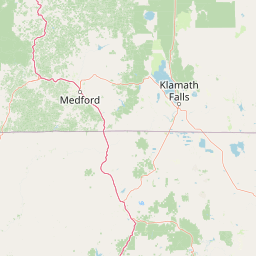
Bays
Fumarole Bay
1,885 m

Detailed analysis of volcanic terrain, mountain relief, and protected land coordinates
Crater Lake National Park encompasses 741.48 square kilometers of high-elevation mountain terrain within Oregon. This geographic profile details the park boundaries, elevation extremes spanning 1883 to 2722 meters, and core landscape features including volcanoes, cliffs, and temperate coniferous forests.
Related tags
Deepest lake in the United States filling a volcanic caldera in southern Oregon
Crater Lake National Park preserves the deep blue waters of Crater Lake, a stunning volcanic caldera formed by the collapse of Mount Mazama approximately 7,700 years ago. Located in southern Oregon, the park encompasses 183,224 acres of mountainous terrain, dense forests, and the remarkable crater lake that has no streams flowing into or out of it. The lake reaches a depth of 1,949 feet, making it the deepest lake in the United States and the second-deepest in North America. This national park, established in 1902 as the fifth-oldest in the United States, represents a rare natural phenomenon where a massive volcanic eruption left behind a nearly symmetrical caldera that gradually filled with precipitation over centuries. The park's setting at the crest of the Cascade Range provides dramatic scenery with the lake's vivid blue color contrasting against surrounding cliffs and forested slopes.
National and regional positioning within the United States
Visualizing the 741.48 square kilometer area and geographic footprint
Mountain relief range and recorded physical features within the park
Bays
1,885 m
Streams
Natural springs
Streams
Ridges
Streams
Analysis of stored landscape features, habitat types, and climate zones
Mountains · Lakes · Cliffs · Forest · Volcano · Cave · Karst
Temperate coniferous forest · Montane forest · Alpine meadow · Riverine habitat · Wetland
Browse the unique protected landscapes and regional geography surrounding Crater Lake, tracing the Cascade Range's volcanic and forest heritage.

Southwest

Tracing volcanic peaks and river-carved mountain terrain in Oregon
Spanning nearly 7,300 square kilometers, the Rogue River, Siskiyou National Forest acts as a crucial ecological anchor in the Pacific Northwest. This overview details its unique mountain geography, the extensive wilderness tracts within its boundaries, and the river systems that define its mountainous character.
North
Southern Cascade Range mountain and forest geography
Mount Thielsen Wilderness offers a compact yet dramatic study of southern Cascade topography. Dominated by its signature lightning-struck volcanic peak, the area encompasses a complex network of glacial cirques, deep valleys, and high-altitude forest zones. This map-rich entry point provides a closer look at the protected boundaries and natural geological features that define this significant segment of Oregon wilderness.
Northwest
High-country wilderness area in southwestern Oregon
Rogue-Umpqua Divide Wilderness preserves a dense, high-elevation ridge environment that separates the Rogue and Umpqua river drainages. Featuring a complex mix of volcanic and sedimentary rock outcrops within a continuous conifer canopy, the area offers a unique look at forest ecology in the Klamath Mountains. The geography provides extensive views across both watersheds and stands as a primary example of protected montane forest terrain within the Oregon landscape.
North
A regional geography of the southern Cascade Range
Umpqua National Forest protects a critical expanse of southern Oregon, rising from river-carved timbered valleys to the high volcanic peaks of the Cascade Range. This atlas record details the forest's significant volcanic geology, sprawling old-growth habitats, and the Wild and Scenic North Umpqua River system. Explore the intricate boundaries of its wilderness areas and its relationship to the surrounding regional terrain through detailed geographic mapping and landscape analysis.
North
Mapped terrain, old-growth forests, and protected wilderness boundaries.
Explore the expansive territory of Willamette National Forest, a primary protected area extending over 100 miles along Oregon's Cascade Range. This region features volcanic peaks exceeding 10,000 feet, extensive old-growth Douglas-fir stands, and a dense network of Wild and Scenic rivers, providing a detailed look at the geographic character and ecological heritage of the Pacific Northwest.
South
Mapping the volcanic cirques and square boundaries of the southern Cascades.
Mountain Lakes Wilderness serves as a primary geographic anchor in the southern Cascades, where shield volcanoes meet glacially carved basins. This protected area contains over twenty lakes situated in high-altitude cirques near the summits of volcanic peaks like Aspen Butte. The area is defined by its distinctive square survey-township boundary, providing a clear footprint of wilderness conservation within the larger Fremont-Winema National Forest terrain.
South
High-desert sagebrush steppe in Northern California
Butte Valley National Grassland is a singular protected landscape in northern California, known for its expansive sagebrush steppe and dry lakebed terrain. Centered in the Klamath River basin, the grassland provides an essential high-desert habitat framed by the dramatic volcanic presence of the Cascade Range and Mount Shasta. This atlas entry details the geography, soil composition, and mountain-framed boundaries of this unique protected area.
East
High elevation terrain in the Fremont Winema National Forest
Spanning the border between Lake and Klamath counties, Gearhart Mountain Wilderness stands as a testament to the diverse mountain geography of south-central Oregon. The area features a complex mosaic of white fir, ponderosa pine, and pure lodgepole stands, set within a glacially sculpted landscape of cirques and ridges. This protected refuge serves as a key headwater source and mountain sanctuary, offering expansive vistas that span from the southern Cascades to the far horizon of the Oregon desert landscape.
Deepen your understanding of Crater Lake National Park's protected landscape by examining its precise geographic setting and mapped boundaries. This national park offers a compelling case study in volcanic geology and caldera formation, vital for any atlas-driven exploration of natural terrains. Continue to discover the distinct regional geography and the unique natural features that define this significant area within Oregon's Cascade Range.