
Streams
Park geography
A comprehensive analysis of land dimensions, regional geography, and environmental features.
Cuyahoga Valley National Park Geographic Profile, Mapped Boundaries, and Natural Terrain
Review the detailed geographic composition of Cuyahoga Valley National Park situated within the state of Ohio. This profile provides structured insights into the recorded 132.7 square kilometer area, boundary-derived span, and key natural features including riverine systems, forested valleys, and identified waterfalls. Explore the physical geography and environmental context defining this protected landscape.
Related tags
National ParkOhioWaterfallsHistoric CanalUrban-Proximate Park
Ohio's only national park, protecting a river valley of forests, waterfalls, and canal history between Cleveland and Akron
Cuyahoga Valley National Park
Cuyahoga Valley National Park is a unique American national park that preserves the natural and cultural landscape along the Cuyahoga River in Northeast Ohio. Established in 2000 as the state's only national park, it encompasses over 32,000 acres of forests, wetlands, rolling hills, and more than 100 waterfalls situated between the metropolitan areas of Cleveland and Akron. The park is distinctive for its extraordinary integration of protected natural areas alongside working farms, small communities, and historic transportation infrastructure. Originally designated as a National Recreation Area in 1974, it became the twelfth most-visited national park in the United States in 2023, drawing nearly 2.9 million visitors who come to explore its trail systems, waterfalls, and well-preserved Ohio and Erie Canal heritage. The park represents a remarkable example of urban-proximate conservation, demonstrating how protected green space can coexist with significant human settlement and activity.
- Location
- United States of America
- Park type
- National park
- Established
- 2000
- Area
- 132.7 km²
Location overview
Administrative placement across Ohio state and county borders
Cuyahoga Valley National Park Regional Geography and Location
Cuyahoga Valley National Park lies within the United States of America, situated in Ohio across Cuyahoga and Summit counties. Official records map out local county jurisdictions and state boundaries.
- Countries
- United States of America
- Regions
- Cuyahoga County, Ohio, Summit County
- Primary location
- Ohio
Boundary and coordinates
Spatial extent and coordinate limits of the 132.7 square kilometer park
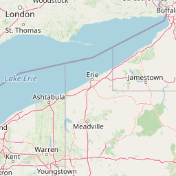
Map and Geographic Boundaries of Cuyahoga Valley National Park
Interactive spatial boundaries trace the physical shape of Cuyahoga Valley National Park to provide clear geographic context. Accompanying geometric facts cover total land area, center coordinates, and spatial spans derived from mapping datasets.
- Boundary area
- 132.4 km²
- Boundary perimeter
- 216.4 km
- Northernmost point
- 41.4205° N
- Southernmost point
- 41.0897° N
- Easternmost point
- 81.4911° W
- Westernmost point
- 81.6483° W
- Geographic centre
- 41.2592° N, 81.571° W
- North–south span
- 36.7 km
- East–west span
- 13.2 km
Terrain and natural features
Explore recorded streams, waterfalls, and viewpoints within the landscape.
Cuyahoga Valley National Park Terrain and Named Natural Features
Recorded natural features within Cuyahoga Valley National Park include rivers, streams, ponds, waterfalls, and scenic overlooks. Linked feature cards supply names, types, and spatial relationships for each recorded entry.
Selected named natural features
Ponds
Garrett Pond
Streams
Rock Creek
Ponds
Whirligig Pond
Viewpoints
Tinker's Creek Gorge Scenic Overlook
Rivers
Chippewa Creek
Environmental setting
Temperate climate zones, mixed relief, and broadleaf forest coverage profiles.
Cuyahoga Valley National Park Environmental Settings and Landscape Classifications
Recorded habitat types and landscape features serve as complementary lenses for interpreting physical terrain profiles across the region. Linked classification records connect specific environmental categories directly to corresponding atlas destinations.
- Relief
- Mixed relief
- Climate
- Temperate
- Water
- Major water bodies
- Forest cover
- Partial forest
- Seasonality
- Seasonal
Landscape features
Forest · Hills · Valleys · Wetland · Rivers · Waterfalls · Cliffs · Cave · Glacier
Habitat types
Temperate broadleaf forest · Grassland · Wetland · Riverine habitat
Park atlas
Trace the regional geography of parks, forests, and other conservation landscapes.
Compare National Parks and Protected Areas Surrounding Cuyahoga Valley National Park, Ohio
Explore additional national parks and protected areas near Cuyahoga Valley National Park, mapping their geographic spread across the surrounding Ohio region and adjacent states. Broaden your understanding of regional conservation landscapes and compare diverse protected terrains, from urban-proximate green spaces to wider natural environments.
Nature reserveOhio
About 72 km away#1 closest
West

Old Woman Creek National Estuarine Research Reserve: Protected Lake Erie Estuary
Northern Ohio coastal wetland and research landscape.
Old Woman Creek National Estuarine Research Reserve represents a vital freshwater estuary on the Lake Erie shore. This reserve protects a unique combination of marsh, swamp forest, and barrier beach, providing significant insight into the natural function of Great Lakes coastal systems in northern Ohio.
- Area
- 2.32 km²
- Established
- 1980
- Relief
- Lowland
- Climate
- Temperate
National parkOntario
89 km away#2 closest
Northwest

Point Pelee National Park: Ontario's National Park Atlas and Protected Landscape Explorer
Mapped geography and protected area context within Ontario.
Point Pelee National Park is a designated national park in Ontario, Canada, offering a unique focus for geographic discovery. This entry details its protected landscape and mapped boundaries, essential for understanding its place within regional park atlases. Explore the core geographic identity of Point Pelee National Park and its significance as a protected natural area.
- Area
- 15 km²
- Established
- 1918
- IUCN
- II
- Visitors
- 491.1K annual
Protected landscapePennsylvania
172 km away#3 closest
East
Allegheny National Forest: Geographic Analysis and Protected Landscape Mapping in Pennsylvania
Rolling plateau topography and expansive hardwood forest conservation zones.
Covering over half a million acres in northwestern Pennsylvania, Allegheny National Forest represents a pivotal protected landscape east of the Mississippi. This overview focuses on the intersection of even-aged timber management, old-growth hemlock stands, and the hydrology of the Allegheny Reservoir. Examine the forest's varied terrain, from ridgelines to riverine islands, through a lens of regional conservation and mapped environmental data.
- Area
- 2,076.75 km²
- Established
- 1923
- Relief
- Upland
- Climate
- Temperate

Protected landscapeOhio
About 181 km away#4 closest
South
Wayne National Forest: Appalachian Protected Landscape and Geographic Atlas
An expansive forest territory within the Unglaciated Allegheny Plateau of Ohio.
Spanning diverse units across southeastern Ohio, Wayne National Forest preserves a rugged mosaic of second-growth forests and historic mining reclamation sites. This protected landscape provides a window into the geology of the Appalachian region, characterized by its distinctive sandstone formations, forested ravines, and extensive long-distance trail connections.
- Area
- 971.65 km²
- Established
- 1992
- Relief
- Upland
- Climate
- Temperate
Protected areaPennsylvania
About 211 km away#5 closest
East
Allegheny National Recreation Area: Protected Geography and Highland Landscapes
Northwestern Pennsylvania plateau and river corridor mapping
Spanning the broad swells of the Allegheny Plateau, this protected area features extensive hardwood forests and the significant reservoir systems of northwestern Pennsylvania. The terrain is characterized by its deep valleys and long-distance trails, providing a comprehensive look at the highland geography preserved within the Allegheny National Forest administrative framework.
- Area
- 81.55 km²
- Established
- 1984
- Relief
- Upland
- Climate
- Temperate

Protected landscapeWest Virginia
255 km away#6 closest
Southeast
Monongahela National Forest: Protected Appalachian Landscapes and Regional Geography
Mapping West Virginia wilderness and mountain terrain
Monongahela National Forest protects nearly one million acres of the central Appalachian Mountains. This massive federally managed landscape is defined by the Allegheny Front, the highest peak in the Allegheny range at Spruce Knob, and iconic geological formations like Seneca Rocks. The region represents a vital intersection of climate, hydrology, and biodiversity in the eastern United States, housing eight distinct wilderness areas and complex high-altitude ecosystems.
- Area
- 3,727.8 km²
- Established
- 1920
- Visitors
- 3M annual
- Relief
- Mountain
Wildlife reserveWest Virginia
290 km away#7 closest
Southeast
Dolly Sods Wilderness: Geography and Protected Landscape Analysis for West Virginia
High-altitude plateaus and sub-arctic Appalachian terrain.
Trace the boundaries and protected landscape of Dolly Sods Wilderness, a 17,000-acre wildlife reserve in West Virginia. This atlas-focused look highlights the area's geological elevation near 4,000 feet, its unique plant communities including sphagnum bogs, and the distinct role of its recovering ecosystems within the larger Monongahela National Forest.
- Area
- 71.94 km²
- Established
- 1975
- IUCN
- Ib
- Visitors
- 7.5K annual
Wildlife reserveWest Virginia
295 km away#8 closest
Southeast
Roaring Plains West Wilderness: Geographic Overview and Protected Plateau Mapping
High-altitude wilderness and Appalachian watershed geography
Roaring Plains West Wilderness encompasses one of the largest high-elevation plateaus in the eastern United States. This protected area within West Virginia hosts dramatic rim-rock vistas and extensive sphagnum bogs, standing as a primary ecological feature along the Eastern Continental Divide. Examine the mapped terrain and environmental boundaries of this significant Allegheny Mountain preserve.
- Area
- 27.6 km²
- Established
- 2009
- IUCN
- Ib
- Relief
- Highland
MoriAtlas Explorer
Continue Exploring Cuyahoga Valley National Park's Geographic and Landscape Identity
Deepen your understanding of Cuyahoga Valley National Park's protected area status and its place within Ohio's geography. This resource offers specific insights into its mapped boundaries and natural terrain, providing a foundation for comprehensive atlas-driven exploration of protected landscapes across the United States.
Browse next
Global natural geography
Explore related park routes
Explore MoriAtlas Global ParksBrowse All MoriAtlas ParksGlobal Park Map DiscoveryMoriAtlas: Browse All CountriesBrowse All MoriAtlas ContinentsNational Park Environment AtlasGrand Canyon National Park AtlasYellowstone National Park AtlasYosemite National Park Atlas and GeographySerengeti National Park AtlasGalápagos National Park Protected LandscapeBanff National Park Geography and AtlasKruger National Park Atlas EntryUluṟu-Kata Tjuṯa National Park AtlasExplore Uluru-Kata Tjuta National Park GeographyPlitvice Lakes National Park AtlasFiordland National Park Protected LandscapeGreat Smoky Mountains National Park AtlasAfghanistan National Parks and Protected AreasAlbania National Parks and Protected AreasAlgeria National Parks and Protected AreasAmerican Samoa National Parks and Protected AreasAndorra National Parks and Protected AreasAngola National Parks and Protected AreasAntarctica National Parks and Protected AreasAntigua and Barbuda Park List