
Mori Atlas logo
Protected landscapePark Krajobrazowy Cysterskie Kompozycje Krajobrazowe Rud Wielkich

A historic forest and wetland network spanning the Silesian Voivodeship and Upper Oder basin

Mapping the Protected Landscape of Park Krajobrazowy Cysterskie Kompozycje Krajobrazowe Rud Wielkich

(Park Krajobrazowy „Cysterskie Kompozycje Krajobrazowe Rud Wielkich”)

Park Krajobrazowy Cysterskie Kompozycje Krajobrazowe Rud Wielkich represents a vast, integrated protected area in southern Poland, defined by its blend of Cistercian cultural heritage and rich riverine ecology. This landscape preserves extensive floodplain and oak-hornbeam forests, alongside historic pond complexes that sustain vital bird habitats. Centered in the Silesian Voivodeship, the terrain demonstrates a legacy of centuries-old land stewardship through water management and sustainable forestry.

landscape parkUpper Oder valleyfloodplain forestoak-hornbeam forestfishpondswetlands
A stylized digital illustration of a mountainous landscape with a river flowing from the center into the foreground, surrounded by coniferous trees and grassy slopes under a pale yellow sun.

Park Krajobrazowy Cysterskie Kompozycje Krajobrazowe Rud Wielkich

Protected landscape

Park overview

Structured park overview, official facts, and landscape profile for Cysterskie Kompozycje Krajobrazowe Rud Wielkich Landscape Park

Cysterskie Kompozycje Krajobrazowe Rud Wielkich Landscape Park park facts, protected area profile, and essential visitor context

Review the core facts for Cysterskie Kompozycje Krajobrazowe Rud Wielkich Landscape Park, including designation, size, terrain, visitor scale, habitats, and operating context in one park-focused overview.

About Cysterskie Kompozycje Krajobrazowe Rud Wielkich Landscape Park

Cysterskie Kompozycje Krajobrazowe Rud Wielkich is a protected landscape area in the western part of Silesian Voivodeship, in the historical Raciborsko-Rybnicka region of southern Poland. It surrounds and overlaps parts of several towns and rural municipalities, including Racibórz, Rybnik, Czerwionka-Leszczyny, Gaszowice, Jejkowice, Knurów, Kornowac, Kuźnia Raciborska, Lyski, Nędza, Orzesze, Pilchowice, Rydułtowy, Sośnicowice, Suszec, and Żory. With a core area of about 493 square kilometers, the park stands among the largest landscape parks in Poland, and its buffer zone adds another roughly 140 square kilometers in five non-contiguous sections.

The park's defining characteristic is the way Cistercian land management has been integrated into a framework of nature protection. When Cistercian monks arrived in Rudy from France in 1258, they introduced a systematic approach to agriculture, forestry, and water management that left durable marks on the terrain. Over the centuries, this monastic landscape evolved into a working cultural landscape of forests, fields, villages, and especially a network of fishponds, of which the Łężczok complex is the most important surviving example.

In addition to its cultural dimension, the park protects significant natural features of the Upper Oder river basin. Forests cover nearly three-fifths of its surface, providing a continuous ecological backdrop across the protected area. The rivers and ponds create habitats for waterbirds and aquatic vegetation, while the floodplains along the Ruda and Oder preserve remnants of riparian and deciduous forest communities that are increasingly rare in the Polish lowlands. The park also preserves elements of the region's industrial past, including remnants of an 18th-century copper forge at Ruda Kozielska, historic iron ore mines at Trachy, ironworks from the 16th to 19th centuries, and post-mining spoil heaps.

Today, the park functions both as a conservation area and as a recreational and educational landscape. Educational centers operate in Rudy, supporting public engagement with the area's natural and cultural heritage, while a network of cultural routes such as the Wooden Architecture Trail of Silesian Voivodeship and the Silesian Technical Monuments Trail highlights the diversity of monuments scattered across the park.

Quick facts and research context for Cysterskie Kompozycje Krajobrazowe Rud Wielkich Landscape Park

Cysterskie Kompozycje Krajobrazowe Rud Wielkich is a landscape park (park krajobrazowy) located in the western part of Silesian Voivodeship, Poland. It was established on 23 November 1993 by regulation of the voivode of Katowice and has been part of the Silesian Voivodeship Landscape Parks Complex since 2000.

The park covers an area of about 49,387 hectares plus a fragmented buffer zone of around 14,010 hectares. Forests dominate the land use, with smaller shares of farmland, water bodies, and built-up areas. Within the park lies the Łężczok nature reserve, created in 1957, and several important Cistercian-era heritage sites.

Protection and recognition

Documented terrestrial protection scope, establishment year, and international recognition details

Park Krajobrazowy Cysterskie Kompozycje Krajobrazowe Rud Wielkich Protection Status and Designation History

Park Krajobrazowy Cysterskie Kompozycje Krajobrazowe Rud Wielkich maintains a documented terrestrial protection status established in 1993. Structured designation history details provide clear insight into the official conservation framework governing this landscape.

Protection details

Protection scope
Terrestrial
Designated year
1993
Transboundary protection
No
Buffer area
140.1 km²
Park context

Deeper park guide and search-rich context for Cysterskie Kompozycje Krajobrazowe Rud Wielkich Landscape Park

Cysterskie Kompozycje Krajobrazowe Rud Wielkich Landscape Park history, landscape, wildlife, and travel context

Explore Cysterskie Kompozycje Krajobrazowe Rud Wielkich Landscape Park through its history, landscape character, ecosystems, wildlife, conservation priorities, cultural context, and seasonal travel timing in a structured park guide built for atlas discovery and search intent.

Why Cysterskie Kompozycje Krajobrazowe Rud Wielkich Landscape Park stands out

The park is best known for being one of the largest landscape parks in Poland and for its strong cultural-ecological identity rooted in the historical Cistercian landscape. Much of its scenery, from the patterns of forests, fields, and fishponds to the surviving monastery-palace complex at Rudy and its English-style park, is directly shaped by centuries of monastic stewardship that began in 1258. It is also distinguished by the Upper Oder valley's natural habitats, especially the floodplain and oak-hornbeam forests that line the rivers and the historic pond network of Łężczok. The combination of extensive woodland, working agricultural land, waterbird-rich wetlands, and industrial-era heritage such as 18th-century copper forges and ironworks creates a layered protected landscape that mixes natural value with deep human history.
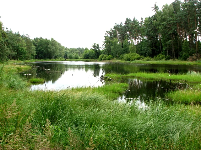
A calm, dark pond surrounded by dense green forest and tall marshy grass in the foreground.
The Chain Pond, known as Staw Lancuchowy, situated within the Cysterskie Kompozycje Krajobrazowe Rud Wielkich Landscape Park.

Cysterskie Kompozycje Krajobrazowe Rud Wielkich Landscape Park history and protected-area timeline

The landscape protection status of Cysterskie Kompozycje Krajobrazowe Rud Wielkich is rooted in a much longer history of human shaping of the terrain. The arrival of Cistercian monks in Rudy in 1258, coming from France, marked the beginning of organized land use in the area. Known for their diligence and good husbandry, the monks introduced systematic agriculture, forestry, and water management, gradually transforming the forested and marshy terrain into a productive and well-ordered cultural landscape.

Over the following centuries, these monastic foundations supported new economic activities. By the 18th century, the area included a copper forge at Ruda Kozielska, while iron ore was mined at Trachy and processed in ironworks that operated from the 16th century through the 19th century. These activities left a layered industrial heritage, from surviving structures to post-exploitation heaps, that is now recognized as part of the park's cultural value.

The formal protection of this combined natural and cultural landscape came relatively late. On 23 November 1993, Regulation No. 181/93 of the Voivode of Katowice established Park Krajobrazowy Cysterskie Kompozycje Krajobrazowe Rud Wielkich. The purpose was to safeguard the natural, cultural, and scenic qualities of the Raciborsko-Rybnicka land. Since 2000, the park has been managed as part of the broader Zespół Parków Krajobrazowych Województwa Śląskiego, the Silesian Voivodeship Landscape Parks Complex, which coordinates management across multiple protected landscapes in the region.

Within the park, the Łężczok nature reserve was created earlier, in 1957, preserving one of the most important fishpond and wetland complexes along the Upper Oder. Its pre-park establishment reflects the long-standing recognition of this area's ecological importance.

Cysterskie Kompozycje Krajobrazowe Rud Wielkich Landscape Park landscape and geographic character

The landscape of Cysterskie Kompozycje Krajobrazowe Rud Wielkich is shaped by the transitional geography of the Upper Oder basin, where river valleys meet the lowlands and uplands of western Silesia. Forests stretch across the majority of the protected area, providing a continuous green backdrop that wraps around agricultural land, villages, and the lattice of ponds and rivers. About 58 percent of the park's surface is forested, while nearly 34 percent remains in agricultural use, giving the area a balanced rural character rather than a purely wild one.

Rivers, especially the Ruda, and the historic fishpond complexes are among the most visually distinctive elements of the landscape. The pond chains, including the celebrated Staw Łańcuchowy (chain pond) and Staw Gichta, create open water surfaces framed by forest, reeds, and meadows. These water features are not only scenic but also ecological keystones, supporting waterbirds and aquatic vegetation throughout the seasons.

Along the rivers, the terrain preserves examples of floodplain morphology typical of the Upper Oder valley. Flat alluvial sections alternate with slightly elevated terraces, and the surviving patches of riparian woodland reflect a historic valley forest pattern that has largely disappeared elsewhere in the region. Around Racibórz, the park extends into the eastern edge of the city, taking in the floodplain of the Kanał Ulga and including the Arboretum Bramy Morawskiej, while in the north it follows the wooded surroundings of Rybnik. The overall impression is of a wide, working landscape where forests, fields, ponds, and small industrial-era villages remain visually integrated.
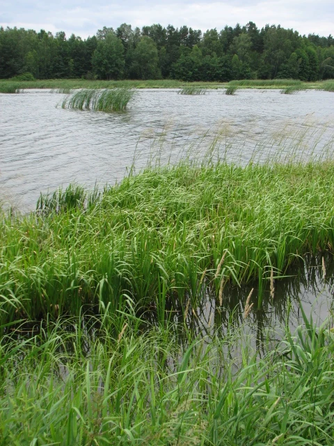
A view of the Gichta pond with tall green grasses in the foreground and a dense forest line in the background under an overcast sky.
Gichta Pond in the Cysterskie Kompozycje Krajobrazowe Rud Wielkich Landscape Park.

Cysterskie Kompozycje Krajobrazowe Rud Wielkich Landscape Park ecosystems, habitats, and plant life

The ecological character of Cysterskie Kompozycje Krajobrazowe Rud Wielkich is defined by the interplay between extensive forest cover, agricultural land, and a network of rivers, ponds, and wetland habitats. Forests dominate the park, and among the most valued components are remnants of natural floodplain forests (lasy łęgowe) and oak-hornbeam forests (grądy) that are characteristic of the Upper Oder valley. These habitats represent a natural forest type that has become rare across the Polish lowlands and gives the park significant conservation relevance beyond its sheer size.

Water is the second pillar of the park's ecological identity. The pond systems, especially within the Łężczok reserve, host breeding waterbirds and provide habitat for rare aquatic and marsh vegetation, including species such as yellow sedge (cibora żółta) and water chestnut (kotewka orzech wodny). These wetland features create diverse microhabitats across the protected area, from open water to reedbeds and seasonally flooded meadows.

The park also contains monuments of animate and inanimate nature, including a notable glacial erratic boulder northeast of Rybnik-Paruszowiec. Together, the surviving floodplain forests, oak-hornbeam woodlands, pond networks, and associated wetland communities form a coherent Upper Oder ecosystem that the park's protection strategy aims to keep ecologically functional while accommodating the long-standing human use of the land.
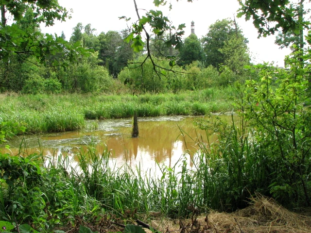
A small, calm pond surrounded by tall grasses, shrubs, and dense forest trees in an outdoor park setting.
A small pond nestled within the greenery of the Cistercian Landscape Compositions in Belk.

Cysterskie Kompozycje Krajobrazowe Rud Wielkich Landscape Park wildlife and species highlights

Wildlife in Cysterskie Kompozycje Krajobrazowe Rud Wielkich is strongly shaped by the abundance of water habitats set within a forested matrix. The fishpond complexes of Łężczok and the broader park function as key breeding, feeding, and resting grounds for waterbirds, making the area regionally important for ornithology within the Upper Oder basin. The combination of open water, reedbeds, meadows, and adjacent woodland supports both water-dependent and forest-interior species across seasons.

The floodplain and oak-hornbeam forests along the rivers provide habitat for forest fauna typical of mixed deciduous woodlands of the region. While many specific species are not detailed in the available source material, the preservation of these forest communities is the principal mechanism by which the park sustains typical lowland forest fauna in the context of a region dominated by agriculture and industry.

The wetland vegetation communities that underpin the park's wildlife value, such as those featuring yellow sedge and water chestnut, indicate sensitive aquatic ecosystems that in turn support invertebrates, amphibians, and fish populations. The Łężczok reserve, as the single formally designated nature reserve within the park, anchors this wildlife profile and provides the core area for conservation-oriented wildlife management.

Cysterskie Kompozycje Krajobrazowe Rud Wielkich Landscape Park conservation status and protection priorities

Cysterskie Kompozycje Krajobrazowe Rud Wielkich plays an important conservation role because of its size and ecological composition in a region heavily shaped by human activity. As one of the largest landscape parks in Poland, it maintains a substantial continuous block of forest, farmland, and wetland that functions as a refugium for Upper Oder natural habitats in an otherwise heavily transformed landscape.

The formal protection framework rests on several layers. The park itself was created in 1993 to safeguard natural, cultural, and scenic values, while the earlier Łężczok nature reserve (1957) provides strict protection for the core pond and wetland complex. Additional protection is afforded to natural monuments, including the glacial erratic northeast of Rybnik-Paruszowiec. The buffer zone around the park, although fragmented into five separate sections, extends the overall protection footprint to roughly 140 square kilometers.

From a habitat perspective, the priority of conservation is the preservation of floodplain and oak-hornbeam forest remnants that are typical of the Upper Oder valley and increasingly rare elsewhere. The protection of pond ecosystems and their associated waterbirds and aquatic flora adds a wetland conservation dimension. By maintaining these habitats within a working cultural landscape and integrating protection with education, including an educational center at Rudy, the park contributes to long-term regional biodiversity conservation rather than serving purely as a strict reserve.

Cysterskie Kompozycje Krajobrazowe Rud Wielkich Landscape Park cultural meaning and human context

The cultural dimension of Cysterskie Kompozycje Krajobrazowe Rud Wielkich is central to its identity and is inseparable from its ecological value. The name itself refers to the Cistercian Landscape Compositions of the Great Rudy, recognizing the monastic origins of much of the present-day scenery. The Cistercians arrived in Rudy from France in 1258 and, through generations of careful agricultural, forestry, and water management, imprinted a distinctive, enduring pattern on the land.

Surviving monastic heritage includes the former Cistercian monastery and palace complex at Rudy, with its church and one of the largest English-style landscape parks in Poland. The preserved fishpond systems, including the Łężczok ponds, represent a continuing Cistercian tradition of managed water landscapes. Remnants of early industrial activity, such as the 18th-century copper forge at Ruda Kozielska, the iron ore mines at Trachy, and ironworks from the 16th to 19th centuries, add a later industrial layer to the cultural story.

The wider cultural landscape also includes wooden churches at Wilcza, Bełk, and Rybnik-Wielopole along the Wooden Architecture Trail of Silesian Voivodeship, as well as manor houses, granaries, forester's lodges, hunting lodges, and a narrow-gauge railway of the Bytom Karb to Markowice Raciborskie line, part of the Silesian Technical Monuments Trail. Together these elements frame the park as a cultural landscape in which monastic, rural, religious, and industrial heritage coexist with natural habitat protection.

Top sights and standout views in Cysterskie Kompozycje Krajobrazowe Rud Wielkich Landscape Park

The highlights of Cysterskie Kompozycje Krajobrazowe Rud Wielkich include its exceptional size among Polish landscape parks and the rarity of its surviving Upper Oder floodplain and oak-hornbeam forests. The Łężczok nature reserve stands out as the keystone wetland, combining historic fishponds with important waterbird breeding habitats and rare aquatic vegetation such as yellow sedge and water chestnut.

Equally important are the layers of human heritage that the park integrates into its protected status: the Cistercian monastery and palace complex at Rudy with its English-style park, the oldest continuously shaped part of the landscape dating back to 1258, and the industrial remnants of 18th-century copper forging and iron ore mining. The narrow-gauge railway, wooden churches on the regional Wooden Architecture Trail, and the network of manor houses and forester's lodges together create a dense cultural tapestry across the protected area.

Best time to visit Cysterskie Kompozycje Krajobrazowe Rud Wielkich Landscape Park

The park's character shifts with the seasons in ways typical of a Central European mid-latitude landscape combining forests, rivers, ponds, and agricultural land. Spring is generally productive for observing revived waterbird activity on the Łężczok ponds and early flowering of wetland vegetation, as well as fresh foliage across the deciduous forest patches. Summer brings dense green forest cover and full agricultural activity across the open fields that make up roughly a third of the park.

Autumn is often visually striking, as the oak-hornbeam and floodplain forests along the Ruda and Oder show strong color change, and the pond landscapes are framed by surrounding autumn-toned woodland. Winter can highlight the broader patchwork of the park, when bare deciduous stands reveal the underlying pattern of fields, villages, and water surfaces. Because much of the park's appeal lies in extended outdoor exploration across forests, ponds, and heritage sites, weather-adapted seasonal visits tend to offer the richest experience, while specific waterbird observation is generally best tied to migration and breeding seasons on the Łężczok ponds.

Monthly climate preview

Long-term monthly temperature and precipitation rhythm for Park Krajobrazowy Cysterskie Kompozycje Krajobrazowe Rud Wielkich

Park Krajobrazowy Cysterskie Kompozycje Krajobrazowe Rud Wielkich Climate and Temperature Normals

Park Krajobrazowy Cysterskie Kompozycje Krajobrazowe Rud Wielkich exhibits measured long-term temperature swings alongside steady daily precipitation averages across twelve distinct periods. Examining the complete monthly climate profile reveals finer shifts in thermal ranges and precipitation totals for this protected landscape.
Annual mean8 °C
-3 °C20 °C
Jan-3°
Feb-2°
Mar
Apr
May14°
Jun18°
Jul20°
Aug20°
Sep14°
Oct
Nov
Dec-2°
Warmest month
July

19.7 °C

Coolest month
January

-3.3 °C

Wettest month
July

3.4 mm/day

Driest month
January

1.6 mm/day

Park location guide

Geography guide, regional context, and park location map for Cysterskie Kompozycje Krajobrazowe Rud Wielkich Landscape Park

Cysterskie Kompozycje Krajobrazowe Rud Wielkich Landscape Park park geography, regions, and map view in Poland

Understand where Cysterskie Kompozycje Krajobrazowe Rud Wielkich Landscape Park sits in Poland through a broader geographic reading of the surrounding landscape, nearby location context, and its mapped position within the national park landscape.

How Cysterskie Kompozycje Krajobrazowe Rud Wielkich Landscape Park fits into Poland

Poland, officially the Republic of Poland, is a Central European country spanning from the Baltic Sea in the north to the Carpathian Mountains in the south. It borders Germany, Czech Republic, Slovakia, Ukraine, Belarus, Lithuania, and Kaliningrad Oblast. The country has a temperate climate, diverse landscapes, and is known for its rich history, cultural heritage, and strong economic position within the EU.

Wider geography shaping Cysterskie Kompozycje Krajobrazowe Rud Wielkich Landscape Park in Poland

Poland occupies 312,696 km2 in Central Europe, extending from the Baltic Sea coast in the north to the Sudetes and Carpathian Mountains in the south. It borders Germany to the west, Czech Republic and Slovakia to the south, Ukraine and Belarus to the east, and Lithuania and Kaliningrad Oblast to the northeast. The landscape includes lowland plains, uplands, and mountain ranges.

Map view of Cysterskie Kompozycje Krajobrazowe Rud Wielkich Landscape Park

Use this park location map to pinpoint Cysterskie Kompozycje Krajobrazowe Rud Wielkich Landscape Park in Poland, understand its exact geographic position, and read its mapped placement within the surrounding landscape more clearly.

Pigeon | © OpenStreetMap contributors

Location context for Cysterskie Kompozycje Krajobrazowe Rud Wielkich Landscape Park

Silesian Voivodeship
Natural feature types

Explore the Natural Landscapes of Park Krajobrazowy Cysterskie Kompozycje Krajobrazowe Rud Wielkich

Examine the specific landforms, water networks, and forest types that populate this protected area. Through MoriAtlas, trace the geographic distribution of these features across the Upper Oder valley to understand the complex environmental patterns shaped by centuries of historical land use.
Recorded earthquake history

Explore Seismic Records for Park Krajobrazowy Cysterskie Kompozycje Krajobrazowe Rud Wielkich

Review the documented history of seismic events associated by proximity with this protected area. MoriAtlas offers a transparent, filterable catalogue of historical records, providing data on epicentre location and magnitude to support deeper geographic understanding of the Upper Oder region.

Park Krajobrazowy Cysterskie Kompozycje Krajobrazowe Rud Wielkich Earthquake History

Catalogued events

465 events

Strongest magnitude

Magnitude 5.1

Most recent event

Jan 27, 2025

This history includes earthquakes recorded inside the park or within 50 km of its borders

Visual exploration of Upper Oder valley forests, historic fishponds, and protected habitats

Park Krajobrazowy Cysterskie Kompozycje Krajobrazowe Rud Wielkich Landscape and Scenery Photos

Photographic records reveal the extensive oak-hornbeam woodlands, floodplain morphology, and historic fishpond networks defining the protected environment of Park Krajobrazowy Cysterskie Kompozycje Krajobrazowe Rud Wielkich. Visual documentation clarifies the layered terrain and cultural scenery shaped across centuries of monastic stewardship in southern Poland.

A calm, dark pond surrounded by dense green forest and tall marshy grass in the foreground.

A calm, slow-moving river flows through a dense forest with overhanging deciduous trees and green banks.

A view of the Gichta pond with tall green grasses in the foreground and a dense forest line in the background under an overcast sky.

A small, calm pond surrounded by tall grasses, shrubs, and dense forest trees in an outdoor park setting.

Park atlas

Explore protected areas, river valleys, and regional landscapes nearby

Parks Near Park Krajobrazowy Cysterskie Kompozycje Krajobrazowe Rud Wielkich

Compare protected areas surrounding Park Krajobrazowy Cysterskie Kompozycje Krajobrazowe Rud Wielkich across the Upper Oder basin. Broaden your geographic exploration by examining adjacent valley terrain, woodland reserves, and regional conservation spaces.
Natural monumentMoravskoslezský kraj
About 18 km away#1 closest

South

Věřňovice Natural Monument: Mapping Protected Floodplain Woodlands in the Moravian-Silesian Region

Geographic overview of the Olše river terrace habitat.

Located near the Czech-Polish border, Věřňovice serves as a vital protected natural monument featuring well-preserved floodplain forest communities. This compact site offers deep insights into river terrace geomorphology and local woodland distribution, characterized by a diverse mosaic of elm and oak-hornbeam stands that support distinct ecological communities.

Area
0.046 km²
Established
1989
IUCN
III
Relief
Lowland
A soft, light-toned watercolor painting of a meandering river through a gentle, rolling landscape with trees and soft hills in the distance.
Protected landscapeSilesian Voivodeship
About 22 km away#2 closest

Northeast

Miechowicka Ostoja Leśna Protected Landscape and Silesian Upland Forest Geography

An industrial-era woodland refuge and arboretum.

Located in the Silesian Voivodeship, this protected landscape preserves a rare blend of native broadleaf forest and exotic arboretum plantings. The area stands as a testament to regional forest recovery, where historic mining heaps and sunken shafts have been integrated into a mosaic of ponds, clearings, and dendrological trails.

Area
3.056 km²
Established
2012
Relief
Lowland
Scope
Terrestrial
Protected areaPoland
23 km away#3 closest

Northeast

Podziemia Tarnogórsko-Bytomskie: Industrial Mining Heritage and Protected Subterranean Landscapes

Historic silver mining tunnels in Upper Silesia, Poland

Explore the geography of Podziemia Tarnogórsko-Bytomskie, a massive subterranean network of shafts, galleries, and adits beneath the Polish countryside. This protected landscape documents centuries of silver and lead extraction while serving as a essential refuge for diverse bat species within the region.

Area
34.908 km²
Established
1955
Access
Easy access
Scope
Terrestrial
Nature reserveSilesian Voivodeship
About 28 km away#4 closest

Southeast

Morzyk Nature Reserve: A Protected Forest Landscape in the Silesian Foothills of Southern Poland

Mapping forest communities and ravine terrain within the Silesian Voivodeship.

Morzyk Nature Reserve protects a rich mosaic of deciduous woodlands and beech-dominated stands in southern Poland. This compact forest reserve offers deep insight into the ecological character of the Silesian Foothills, featuring well-preserved ravines and old-growth trees that anchor the regional geography.

Area
0.103 km²
Established
1996
Relief
Upland
Climate
Temperate
A horizontal watercolor painting depicting soft, layered green hills and purple-toned mountain ridges in the distance, with a foreground of stylized evergreen trees.
Protected landscapeSilesian Voivodeship
30 km away#5 closest

Southeast

Park Krajobrazowy Beskidu Śląskiego: Geographic Atlas of Protected Silesian Beskid Landscapes

Mapped mountain ridges, river headwaters, and protected forest reserves.

Gain insight into the ecological and structural character of Park Krajobrazowy Beskidu Śląskiego. This resource documents the park's flysch geological formations, rare cave systems, and the hydrological significance of the Vistula River headwaters within the Silesian Beskids.

Area
386.2 km²
Established
1998
Relief
Mountain
Climate
Alpine
Nature reservePoland
31 km away#6 closest

Southeast

Kościół w Górkach Wielkich: Nature Reserve and Protected Habitat in Silesian Voivodeship

Mapping cultural heritage and ecological sanctuary boundaries

Explore the geography of Kościół w Górkach Wielkich, a specialized Natura 2000 protected site situated within the Brenna commune. This entry provides context on the church architecture and the local protected terrain that creates a essential roost for regional bat populations in the Silesian Beskids foothills.

Relief
Lowland
Scope
Terrestrial
Water
Minor water
A soft watercolor illustration depicting a green, open floodplain with rows of trees under a pale, gentle sky.
Nature reserveMoravskoslezský kraj
About 33 km away#7 closest

Southwest

Polanský les Nature Reserve: Mapped Protected Landscape and Floodplain Geography

A preserved hardwood forest relic in the Ostrava region

Polanský les maintains a critical status as a protected nature reserve, safeguarding a relic hardwood floodplain forest along the Oder River. This area is characterized by its significant botanical diversity, including established snowdrop populations and mature broadleaf woodland. Its location within the Moravskoslezský kraj highlights its role as a dense ecological fragment at the geological boundary between the Bohemian Massif and the Outer Western Carpathians.

Area
0.598 km²
Established
1970
IUCN
IV
Relief
Lowland
A horizontal watercolor painting depicting a soft green landscape with rolling hills, distant light purple mountain ridges, and a central water feature, rendered in a light, atmospheric style.
Protected landscapeSilesian Voivodeship
About 35 km away#8 closest

Southeast

Dolina Wapienicy: Protected Landscape and Carpathian Mountain Valley in Silesian Voivodeship

Mapped terrain, forest ecosystems, and ridge geography

Dolina Wapienicy acts as a protected landscape complex within the urban-adjacent geography of the northern Silesian Beskids. The area encompasses mature Carpathian beech forests and rare upper montane spruce stands, organized around the Wapienica River and the Mościcki Dam reservoir. It remains a focal point for understanding how mountain valley systems maintain biodiversity and near-natural wilderness characteristics in close proximity to major urban settlements.

Area
15.19 km²
Established
1993
Relief
Mountain
Climate
Temperate

Common questions about visiting, size, designation, and location context for Cysterskie Kompozycje Krajobrazowe Rud Wielkich Landscape Park

Cysterskie Kompozycje Krajobrazowe Rud Wielkich Landscape Park FAQs for park facts, access, geography, and protected area context

Find quick answers about Cysterskie Kompozycje Krajobrazowe Rud Wielkich Landscape Park, including protected-area facts, park geography, trail and visitor context, and how the park fits into its surrounding country and regional landscape.
MoriAtlas Explorer

Continue Your Protected Areas Search Across the Global Atlas

Deepen your exploration by continuing the structured search for national parks and protected areas worldwide. Utilize the comprehensive filtering capabilities to compare different conservation landscapes and refine your understanding of global park geography. Discover more about the distribution and characteristics of protected natural areas.

Global natural geography