Mori Atlas logo
Biosphere reserveDyfi Biosphere

Explore the geographic mosaic of salt marshes, Atlantic woodlands, and active mire habitats in western Britain

Dyfi Biosphere: A Protected Landscape of Estuarine Wetlands, Raised Mires, and Coastal Dunes in Wales

The Dyfi Biosphere represents a unique convergence of protected land in south-central Wales, where the River Dyfi estuary meets the waters of Cardigan Bay. This landscape features a classic bar-built estuarine system, extensive salt marshes, and the primary raised mire of Cors Fochno, one of the most intact peatlands in the United Kingdom. Inland, the catchment area transitions from damp sessile oak woodlands through rolling valley slopes into upland acid grassland and heath, creating a complex, integrated terrain of significant ecological importance.

biosphere reserveestuarysalt marshraised mirepeatlandsand dunes

Dyfi Biosphere

Biosphere reserve

Park overview

Structured park overview, official facts, and landscape profile for Dyfi Biosphere

Dyfi Biosphere park facts, protected area profile, and essential visitor context

Review the core facts for Dyfi Biosphere, including designation, size, terrain, visitor scale, habitats, and operating context in one park-focused overview.

About Dyfi Biosphere

The Dyfi Biosphere occupies a distinctive position on the Welsh coast, where a relatively short river system delivers freshwater and sediments into a wide, shallow bay. The combination of a low-gradient catchment, strong tidal influence, and an offshore sand bar has shaped an estuary that is sandy, nutrient-poor, and ecologically rich. The biosphere's boundaries extend beyond the shoreline to include the inland valleys that drain into the Dyfi, giving the reserve a structure that links upland, woodland, mire, and coast in a single landscape unit.

Within this broader setting, several core areas stand out. Cors Fochno, a primary raised mire inland from the estuary, preserves centuries of peat accumulation in conditions close to those that once dominated much of lowland Britain. Its invertebrate fauna includes species of national and international importance, and its undisturbed hydrology makes it a key reference site for understanding peatland behavior in a changing climate. At the coast itself, the Ynyslas dune system forms an accreting sand spit that supports successive stages of dune community development, including foredunes dominated by marram grass and more humid slack habitats behind them.

The inland component of the biosphere is equally varied. The Dyfi is a post-glacial catchment where thin, acidic soils developed on lower Palaeozoic sedimentary rocks give rise to a mix of broadleaf woodland, conifer plantation, acid grassland, blanket bog, and dwarf shrub heath. Native oak and ash woodland survives along the valley slopes and in tributary valleys, and these damp, shaded woods are particularly notable for their bryophyte, lichen, and fern communities, with a strong representation of Atlantic bryophyte species. Above the valley, upland moorland continues into the larger surrounding hill masses that provide habitat for important populations of breeding and wintering birds.

At the seaward edge, the estuary is fringed by extensive salt marshes, including stands of Atlantic salt meadow vegetation. The combination of salt marsh, mudflat, and open water provides feeding and roosting habitat for migratory fish, wintering wildfowl, waders, and otters. This ecological diversity, along with the biosphere's long history of active management, makes Dyfi an unusually complete example of the British west-coast estuarine landscape.

Quick facts and research context for Dyfi Biosphere

The Dyfi Biosphere lies along the coast of south-central Wales, in the estuary of the River Dyfi. It was designated in 1977 and covers a core protected area on the order of 1,500 hectares. It functions as a UNESCO biosphere reserve representative of salt marshes and estuarine systems in western Britain and includes Ramsar-recognized wetland habitat.

The reserve pairs a coastal bar-built estuary with an inland raised mire system at Cors Fochno and Ynyslas dune spit, supplemented by broadleaf woodlands along the valley slopes and acid moorland on the surrounding hills. Its combined ecological, educational, and cultural roles make it one of the most recognizable biosphere designations in Wales.

Protection and recognition

Examine the documented protection scope and management background for Dyfi Biosphere.

Dyfi Biosphere Protection Status and Conservation Recognition Facts

Analysis of Dyfi Biosphere reveals a mixed protection scope outlining regional management boundaries and administrative frameworks. Reviewing these verified records provides clear insight into the conservation status governing this protected landscape.

Protection details

Protection scope
Mixed
Transboundary protection
No
Park context

Deeper park guide and search-rich context for Dyfi Biosphere

Dyfi Biosphere history, landscape, wildlife, and travel context

Explore Dyfi Biosphere through its history, landscape character, ecosystems, wildlife, conservation priorities, cultural context, and seasonal travel timing in a structured park guide built for atlas discovery and search intent.

Why Dyfi Biosphere stands out

The biosphere is best known for its pairing of a classic sand-dominated Welsh estuary with one of the country's largest surviving raised mires. Cors Fochno is widely regarded as a benchmark example of an actively growing peatland, valuable both for its invertebrate diversity and its role in climate-related research, while the adjacent Ynyslas dunes illustrate a clear sequence of dune succession from marram foredunes through to humid dune slacks. It is also highly regarded as a wintering and passage site for waterbirds. The estuary ranks among the foremost wildfowl and shorebird centers in Wales and forms part of the wider network of internationally important wetlands recognized through its Ramsar listing. Together, these features give the biosphere a strong identity as a meeting place of mosses, dunes, salt marsh, and migratory birds.
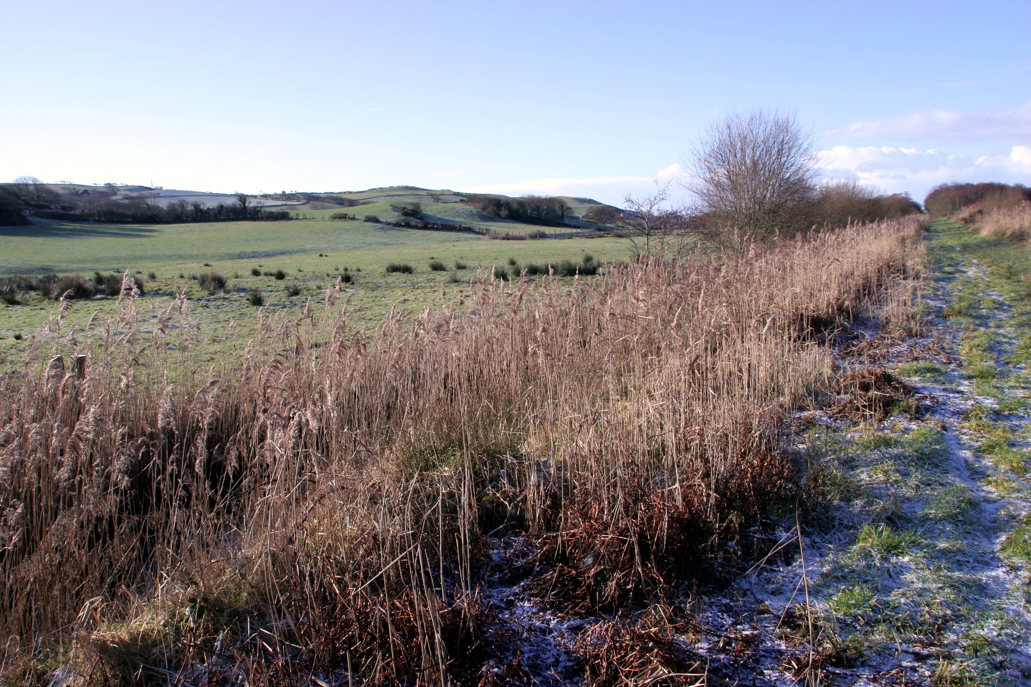
A dirt path runs alongside a patch of tall, dry, brown marsh grasses under a clear blue sky, with frosty green fields and rolling hills in the distance.
A frost-covered trail bordering the marshy landscape of Cors Fochno.

Dyfi Biosphere history and protected-area timeline

The Dyfi Biosphere was formally designated in 1977, joining the early cohort of UNESCO Man and the Biosphere reserves recognized in the United Kingdom. Its designation reflected both the regional importance of the estuary as a waterbird habitat and the wider significance of Cors Fochno as one of the country's most intact primary raised mires. The international standing of its wetland habitats was later reinforced through Ramsar recognition.

Over the following decades, the biosphere evolved from a primarily conservation-focused designation into a broader landscape-scale initiative. Activities within the reserve expanded to include pastoral farming and forestry, sustainable living initiatives, technology development, environmental education, resource monitoring, and cultural programming, in keeping with the biosphere reserve concept of integrating conservation with sustainable human use. The site also took on a growing role in climate-related research, given the value of its active raised mire as a long-term ecological reference.

National designations, including National Nature Reserve and Site of Special Scientific Interest status, overlay parts of the area, reinforcing protection at the domestic level alongside the biosphere's international framework. This layered system of recognition has helped shape decades of monitoring, restoration, and research effort in the estuary and its surrounding catchments.

Dyfi Biosphere landscape and geographic character

The Dyfi Biosphere sits within a post-glacial landscape shaped by relatively soft Palaeozoic rocks and thin, acidic soils. Inland, the catchment is composed of rolling hill land that dips toward the estuary, with the valley slopes carrying native broadleaf woodland and the higher ground giving way to acid grassland, blanket bog, and dwarf shrub heath. These upland surfaces often flow into larger surrounding moorland masses, producing wide, open skylines above the wooded valleys.

The valley woodlands themselves contrast sharply with the open upland. Sessile oak and ash dominate the steeper slopes and tributary valleys, while conifer plantations occupy some of the broader, flatter slopes. The ground beneath these woods is damp and shaded, allowing an unusually rich cover of bryophytes, lichens, and ferns, including many Atlantic species that depend on the mild, humid conditions of western Britain.

The coastal landscape is defined by the bar-built estuary itself. A wide, shallow, sandy inlet receives freshwater from the Dyfi and sediments from the surrounding shorelines, while an offshore sand bar shelters the inner bay from the open sea. Within the estuary, broad mudflats give way to fringing salt marsh communities, notably Atlantic salt meadow. At the mouth of the system, the Ynyslas dune spit extends as an actively accreting sand formation, showing clear successional zones from open foredunes dominated by marram grass through more established dune communities and into humid dune slacks. Behind the spit lies Cors Fochno, a flat expanse of raised mire that contrasts markedly with the surrounding dunes and estuary.

Dyfi Biosphere ecosystems, habitats, and plant life

The ecology of the Dyfi Biosphere is built around the interaction between an acidic, upland-and-valley catchment and a sandy, tidal estuary. Inland, native broadleaf woodland dominated by sessile oak and ash on the valley slopes supports populations of typical woodland birds and a rich assemblage of lower plants, including an unusually high representation of Atlantic bryophytes, lichens, and ferns. Above the woodland, mixtures of acid grassland, blanket bog, and dwarf shrub heath on the uplands extend into larger surrounding moorland, creating continuous habitat for ground-nesting birds and other moorland species.

The wetland habitats are particularly important. The estuary and its associated salt marshes support extensive populations of invertebrates and provide feeding grounds for migratory fish. Cors Fochno, in the freshwater zone behind the dunes, is one of the largest and best preserved active raised bogs in the United Kingdom, with peat-forming vegetation, bog pools, and conditions favorable to a wide range of specialist invertebrates. The Ynyslas dune system, with its gradient from active foredunes through more stable dunes to humid slack communities, supports a structured dune flora and associated fauna.

Together, these habitats represent an unusually complete sequence of British west-coast environments at a relatively compact scale. The combination of brackish, freshwater, dune, bog, woodland, and moorland gives the biosphere a layered ecological identity in which coastal and inland processes continually interact.

Dyfi Biosphere wildlife and species highlights

The Dyfi Biosphere is internationally recognized as a key site for waterbirds, with the estuary functioning as one of the foremost wildfowl and shorebird centers in Wales. The mudflats and salt marshes regularly support large wintering populations of waders and wildfowl, while the open water and fringing habitats attract passage species moving along the Welsh coast. The combination of estuarine feeding areas and nearby raised bog, dune, and woodland habitats means that a wide range of birdlife can be present within the biosphere at different times of year.

The river corridor and estuary also support important populations of migratory fish and otters, both of which depend on the continuity of habitat between freshwater and tidal reaches. Inland, the mix of broadleaf woodland, conifer plantation, acid grassland, and moorland supports characteristic woodland and upland bird communities, including species typical of Welsh hill country and Atlantic woodland.

Cors Fochno's invertebrate fauna is of particular note. The undisturbed, waterlogged peat and associated bog vegetation provide conditions for populations of invertebrates of national and international importance, including groups that have become scarce elsewhere in lowland Britain. The dune system at Ynyslas adds its own invertebrate and small vertebrate interest, while the salt marshes and estuarine flats support rich communities of estuarine invertebrates that, in turn, underpin the food chains relied on by the bird populations.

Dyfi Biosphere conservation status and protection priorities

From a conservation perspective, the Dyfi Biosphere protects a nationally and internationally significant mosaic of coastal and inland habitats. Its Ramsar designation recognizes the estuary and associated wetlands as wetland of international importance, particularly for their role in supporting migratory and wintering waterbirds. Cors Fochno's status as one of the largest intact active raised mires in the United Kingdom gives it particular scientific value, as such sites are increasingly rare and provide long-term records of peat accumulation and carbon storage.

The site also functions as a key reference for climate-related research. Active raised mires like Cors Fochno, along with the broader catchment's blanket bogs and upland habitats, offer valuable baseline data on how British wetland systems respond to changing climate and land use. The dune and woodland systems, including the Atlantic bryophyte-rich damp woods, add complementary dimensions to this monitoring role.

Within the United Kingdom, parts of the biosphere are protected as a National Nature Reserve and as Sites of Special Scientific Interest, adding domestic regulatory protection to the international UNESCO biosphere framework. This layered status has supported sustained management effort aimed at balancing habitat protection, scientific monitoring, ecological restoration, and the sustainable human activities that are central to the biosphere concept.

Dyfi Biosphere cultural meaning and human context

The Dyfi Biosphere reflects a long history of human interaction with the landscape of mid Wales. Pastoral farming and forestry have shaped much of the valley and upland character for generations, while fishing and navigation along the estuary are part of the longer coastal heritage of the region. Today, these traditional land uses operate alongside environmental education, sustainable living initiatives, and cultural programming that are integral to the biosphere reserve concept.

The bilingual Welsh-English cultural context is part of the biosphere's identity, with the reserve known in Welsh as Biosffer Dyfi. Cultural activities within the reserve, including interpretation and community engagement, reflect the broader Welsh tradition of linking rural livelihoods, language, and landscape.

Top sights and standout views in Dyfi Biosphere

The biosphere's most distinctive strengths are the combination of an internationally important bar-built estuary with the nearby primary raised mire of Cors Fochno, and the active dune succession of the Ynyslas spit. Together these sites provide a rare, compact example of linked salt marsh, dune, bog, woodland, and moorland habitats within a single protected landscape.

Equally notable is the biosphere's layered protection, from UNESCO biosphere reserve and Ramsar status down to national designations, and its strong identity as a working landscape where pastoral farming, forestry, education, monitoring, and sustainable living continue alongside conservation.

Best time to visit Dyfi Biosphere

The Dyfi Biosphere presents a substantially different character across the seasons, and the timing of a visit often depends on what a visitor hopes to see. Winter brings the largest concentrations of migratory and wintering wildfowl and waders to the estuary, when the mudflats and salt marshes can be particularly active with feeding and roosting flocks. At the same time, cooler, wetter conditions can emphasize the saturated, moss-dominated character of Cors Fochno and the damp Atlantic woodlands of the valley slopes.

Spring and summer shift the focus inland and to the dune system. The dune slacks and salt marshes come into flower, woodland bird activity increases, and the estuary continues to host breeding and passage species. Upland moorland and blanket bog remain accessible, though weather conditions in the hills can be changeable. Autumn marks the early return of overwintering birds to the estuary, gradually building toward the winter peak.
Monthly climate preview

Long-term representative point measurements tracking monthly weather patterns across the landscape

Dyfi Biosphere Climate Normals, Annual Temperature and Precipitation Rhythm

Temperature and precipitation data for Dyfi Biosphere trace a measured annual cycle from winter lows to midyear warmth based on NASA observations between 1991 and 2020. Reviewing the complete twelve-month climatology profile reveals precise monthly averages for sustainable environmental analysis.
Annual mean9 °C
4 °C15 °C
Jan
Feb
Mar
Apr
May10°
Jun13°
Jul15°
Aug14°
Sep12°
Oct
Nov
Dec
Warmest month
July

14.6 °C

Coolest month
January

3.5 °C

Wettest month
December

4.6 mm/day

Driest month
April

2.6 mm/day

Park location guide

Geography guide, regional context, and park location map for Dyfi Biosphere

Dyfi Biosphere park geography, regions, and map view in United Kingdom

Understand where Dyfi Biosphere sits in United Kingdom through a broader geographic reading of the surrounding landscape, nearby location context, and its mapped position within the national park landscape.

How Dyfi Biosphere fits into United Kingdom

The United Kingdom is a parliamentary constitutional monarchy located in northwestern Europe, consisting of four constituent countries: England, Scotland, Wales, and Northern Ireland. As a major global power with over 69 million residents, it maintains significant international influence in politics, economics, and culture.

Wider geography shaping Dyfi Biosphere in United Kingdom

The United Kingdom is an island nation located in northwestern Europe, surrounded by the Atlantic Ocean, North Sea, English Channel, Celtic Sea, and Irish Sea. It shares a land border with the Republic of Ireland to the west. The territory includes the island of Great Britain, the northeastern portion of Ireland, and most of the smaller British Isles islands.

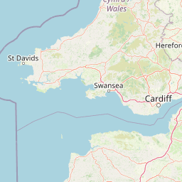
Map view of Dyfi Biosphere

Use this park location map to pinpoint Dyfi Biosphere in United Kingdom, understand its exact geographic position, and read its mapped placement within the surrounding landscape more clearly.

Pigeon | © OpenStreetMap contributors

Location context for Dyfi Biosphere

Wales

Explore protected area photography capturing estuarine salt marshes, active sand dunes, and raised mires.

Dyfi Biosphere Photos and Landscapes: Visualizing the Estuary and Protected Terrain

Visual documentation reveals the distinct topography and linked habitats that define Dyfi Biosphere across its coastal and inland zones. Photographic records provide clear visual context for understanding estuarine ecosystems, dune succession, and protected Welsh landscapes.

A dirt path runs alongside a patch of tall, dry, brown marsh grasses under a clear blue sky, with frosty green fields and rolling hills in the distance.

Park atlas

Compare regional geography and surrounding coastal reserves.

Parks Near Dyfi Biosphere And Connected Protected Landscapes

Browsing other protected areas near Dyfi Biosphere reveals broader ecological patterns across the surrounding region. Regional park comparison provides deeper context for estuarine habitats, raised mires, and coastal dunes.
Watercolor illustration of rolling mountains and green valleys with distant peaks
National parkWales
About 24 km away#1 closest

North

Snowdonia National Park: Protected Landscape and Map Exploration in North Wales

Mountain terrain, glacial lakes, and regional geography.

Snowdonia National Park offers a profound exploration of mountainous protected landscapes in North Wales. This page details the park's mapped boundaries, revealing a terrain shaped by glaciation, featuring dramatic peaks like Snowdon, steep valleys, and pristine glacial lakes. Understand its geographic identity within the United Kingdom and how its protected status contributes to the regional landscape context, providing a unique focus for atlas-based discovery.

Area
2,142 km²
Established
1951
IUCN
V
Relief
Mountain
Watercolor illustration of a mountainous landscape with lakes and greenery
National parkWales
About 39 km away#2 closest

Southeast

Brecon Beacons National Park: Explore Wales' Iconic Protected Mountain Landscape

Discover mapped terrain, park boundaries, and regional geography.

Brecon Beacons National Park, officially Bannau Brycheiniog, stands as a premier protected area within Wales, covering over 1,344 square kilometers of striking mountainous terrain. This national park is defined by its dramatic Old Red Sandstone ranges, including Pen y Fan, South Wales' highest peak, and features diverse landscapes from heather moorland to extensive river valleys. Its mapped boundaries encompass unique geological features, significant historical sites, and provide context for regional geographic exploration, making it a key destination for understanding protected lands in the UK.

Area
1,344 km²
Established
1957
IUCN
V
Visitors
4.4M annual
National parkPembrokeshire
About 53 km away#3 closest

Southwest

Pembrokeshire Coast National Park: Mapped Coastal Boundaries and Protected Landscape Atlas

Explore unique seaside terrain and regional geography.

Delve into the Pembrokeshire Coast National Park, a premier protected landscape recognized for its extraordinary coastal formations and diverse natural terrain. This atlas entry details the park's distinct mapped boundaries, from its iconic limestone cliffs and sea stacks to its sheltered estuaries and inland Preseli Hills. Understand how this significant national park contributes to the protected area map of Pembrokeshire and offers unparalleled opportunities for geographic discovery along the Welsh coast.

Area
629 km²
Established
1952
IUCN
V
Relief
Mixed relief
Watercolor painting depicting a landscape with rolling hills, a winding road, and distant mountains
National parkUnited Kingdom
About 120 km away#4 closest

South

Exmoor National Park: A Premier Protected Landscape in South West England for Atlas Exploration

Mapped terrain, moorland, and dramatic coastal geography.

Discover Exmoor National Park, a vast protected area in South West England celebrated for its sweeping heather moorland, dramatic coastline with the highest sea cliffs on mainland Britain, and deep, ancient wooded valleys. This national park offers a unique landscape for atlas-based exploration, revealing its distinct geography, mapped boundaries, and rich terrain shaped by centuries of natural processes and human activity.

Area
692 km²
Established
1954
IUCN
V
Visitors
1.4M annual
A soft watercolor illustration featuring rolling hills in the background, a tree line in the midground, and a winding waterway in the foreground.
Biosphere reserveDevon
About 140 km away#5 closest

South

North Devon's Biosphere Reserve: Protected Landscapes and Geographic Map Exploration

Coastal dunes, estuaries, and marine habitats in North Devon

An extensive overview of North Devon's Biosphere Reserve, highlighting its role as a protected landscape in South West England. Analyze the distribution of its diverse terrain, including Britain's largest sand dune system, river catchments, and offshore coral reefs, through detailed geographic and habitat mapping.

Area
5,262 km²
Established
1976
Visitors
4M annual
Relief
Lowland
Watercolor painting of a wetland landscape featuring a winding river, rolling green hills, and soft-focus trees under a light sky.
Protected landscapeSomerset
About 146 km away#6 closest

Southeast

Somerset Levels Protected Landscape: Geographic Mapping and Wetland Terrain Analysis

A low-lying coastal plain and historic wetland basin in Somerset

Examine the distinct topography of the Somerset Levels, where flat horizons, pollarded willows, and ancient drainage channels create a unique English landscape. This protected area offers deep insight into prehistoric archaeology, including preserved Neolithic trackways, alongside modern wetland conservation of international significance within a rural basin.

Area
650 km²
Established
1997
Relief
Lowland
Climate
Temperate
National parkUnited Kingdom
About 160 km away#7 closest

Northeast

Peak District National Park: Explore Protected Landscape and Regional Geography

Mapped boundaries and natural terrain context for this UK national park.

Investigate the Peak District National Park, a cornerstone of the United Kingdom's protected natural areas. This MoriAtlas entry provides essential details on its geographic scope, mapped boundaries, and landscape characteristics. Engage with structured data to understand how this national park fits into the atlas of the United Kingdom, supporting detailed geographic and protected-area discovery for researchers and explorers.

Area
1,440 km²
Established
1951
IUCN
V
Visitors
13M annual
Watercolor illustration of a landscape with mountains, a lake, and trees
National parkCounty Wicklow
About 172 km away#8 closest

Northwest

Wicklow Mountains National Park: Protected Landscape and Geographic Atlas Mapping

Explore County Wicklow's mapped natural terrain and park boundaries.

Understand the geographic scope and protected landscape identity of Wicklow Mountains National Park. This page offers detailed information on its mapped boundaries and its context within County Wicklow, providing a foundation for atlas-based discovery of Ireland's natural areas. Explore how this national park contributes to the region's mapped geography and conservation landscapes.

Area
205 km²
Established
1991
IUCN
II
Relief
Mountain

Common questions about visiting, size, designation, and location context for Dyfi Biosphere

Dyfi Biosphere FAQs for park facts, access, geography, and protected area context

Find quick answers about Dyfi Biosphere, including protected-area facts, park geography, trail and visitor context, and how the park fits into its surrounding country and regional landscape.
MoriAtlas Explorer

Continue Your Protected Areas Search Across the Global Atlas

Deepen your exploration by continuing the structured search for national parks and protected areas worldwide. Utilize the comprehensive filtering capabilities to compare different conservation landscapes and refine your understanding of global park geography. Discover more about the distribution and characteristics of protected natural areas.

Global natural geography