

Mori Atlas logo
Marine protected areaEast Gippsland Commonwealth Marine Reserve

Analyzing the oceanographic dynamics and seafloor geography off the Victorian coastline.

East Gippsland Commonwealth Marine Reserve: A Regional Mapping of Marine Protected Landscapes

The East Gippsland Commonwealth Marine Reserve preserves over four thousand square kilometers of the Tasman Sea, forming a critical component of the South-east Commonwealth Marine Reserve Network. This protected area represents an oceanographic crossroads where the warm East Australian Current meets cooler southern waters, driving complex eddy formation and high phytoplankton productivity near Cape Howe. Our atlas data maps these fluid boundaries to illustrate how this marine protected area maintains its ecological function as a Multiple Use zone.

marine protected areaTasman Seasouth-eastern AustraliaIUCN Category VIMultiple Use zonewarm-temperate waters

East Gippsland Commonwealth Marine Reserve

Marine protected area

Park overview

Structured park overview, official facts, and landscape profile for East Gippsland Commonwealth Marine Reserve

East Gippsland Commonwealth Marine Reserve park facts, protected area profile, and essential visitor context

Review the core facts for East Gippsland Commonwealth Marine Reserve, including designation, size, terrain, visitor scale, habitats, and operating context in one park-focused overview.

About East Gippsland Commonwealth Marine Reserve

East Gippsland Commonwealth Marine Reserve is an Australian federal marine protected area covering a substantial section of the Tasman Sea along the country's south-eastern coastline. Its waters lie off the region where the state of New South Wales meets the coast of Victoria, framing the marine park as an ecological bridge between two distinct climatic and oceanic zones.

The reserve was created in 2007 as part of the wider South-east Commonwealth Marine Reserve Network, an initiative that grouped several Australian Commonwealth marine reserves into a single coordinated conservation framework. This institutional context places the East Gippsland reserve within a broader national effort to manage ocean ecosystems at the federal level.

Oceanographically, the reserve occupies a transitional zone. Warmer subtropical waters travel southward along the coast via the East Australian Current, while cooler temperate waters dominate further offshore and to the south. Where these systems meet, particularly in the vicinity of Cape Howe, large eddies form, stirring nutrients and supporting rich phytoplankton blooms. The result is a productive marine environment capable of sustaining varied marine life across a comparatively large area of open ocean.

Management of the reserve follows a Multiple Use approach, meaning the area is not closed to all human activity but is instead regulated to balance conservation goals with compatible uses. Parks Australia administers the reserve on behalf of the Commonwealth, overseeing the permitted activities and the protections that keep this dynamic marine environment intact for the long term.

Quick facts and research context for East Gippsland Commonwealth Marine Reserve

East Gippsland Commonwealth Marine Reserve lies in the Tasman Sea off the coast of Australia's south-eastern corner, near the New South Wales and Victoria border. It covers roughly 4,137 square kilometres of ocean and was established on 31 August 2007. The reserve is managed by Parks Australia under the Commonwealth of Australia as part of the South-east Commonwealth Marine Reserve Network.

The reserve is classified as IUCN Category VI and is entirely zoned as Multiple Use. Recreational fishing is permitted throughout, while commercial fishing and mining may occur only with approval. The nearest onshore town is Mallacoota, Victoria.

Protection and recognition

Documented marine protection status, management scope, and international recognition facts

East Gippsland Commonwealth Marine Reserve Protection Status and Recognition

Marine protection status and management scope for East Gippsland Commonwealth Marine Reserve compile official records into a clear baseline. Documented designations provide essential context for understanding the conservation framework governing this marine reserve.

Protection details

Protection scope
Marine
Transboundary protection
No
Park context

Deeper park guide and search-rich context for East Gippsland Commonwealth Marine Reserve

East Gippsland Commonwealth Marine Reserve history, landscape, wildlife, and travel context

Explore East Gippsland Commonwealth Marine Reserve through its history, landscape character, ecosystems, wildlife, conservation priorities, cultural context, and seasonal travel timing in a structured park guide built for atlas discovery and search intent.

Why East Gippsland Commonwealth Marine Reserve stands out

East Gippsland Commonwealth Marine Reserve is best known for the convergence of warm and temperate ocean waters off Cape Howe. The east-flowing East Australian Current carries subtropical water southward, producing large eddies where it meets cooler southern waters. This oceanographic mixing supports strong phytoplankton productivity and underpins the marine life the reserve is designed to protect. The reserve is also recognised as part of a coordinated national approach to marine conservation, sitting within the South-east Commonwealth Marine Reserve Network alongside other federal marine reserves in the region.

East Gippsland Commonwealth Marine Reserve history and protected-area timeline

The East Gippsland Commonwealth Marine Reserve was officially established on 31 August 2007, marking a deliberate step in Australia's development of a national system of Commonwealth marine reserves.

Its creation positioned it as part of the South-east Commonwealth Marine Reserve Network, a coordinated grouping of federal marine reserves along Australia's south-eastern seaboard. This reflects a broader shift in Australian marine governance during the 2000s, when the Commonwealth assumed an increasingly structured role in offshore habitat protection.

The reserve's Multiple Use zoning reflected an approach that combined conservation objectives with regulated ongoing uses, setting the framework that continues to define how the area is administered by Parks Australia under Commonwealth oversight.

East Gippsland Commonwealth Marine Reserve landscape and geographic character

Although the East Gippsland Commonwealth Marine Reserve is an offshore, open-ocean reserve rather than a terrestrial park, its physical character is defined by ocean dynamics and seafloor features rather than mountains, forests, or coastlines in the conventional sense.

The dominant landscape element is water, covering approximately 4,137 square kilometres of the Tasman Sea. The reserve's seafloor and surrounding waters lie in a region known for variable depths and complex current patterns, particularly where the southward-flowing East Australian Current interacts with cooler southern waters.

Cape Howe, located near the New South Wales and Victoria border, plays a pivotal role in shaping the reserve's marine landscape. The cape's geography influences how warm eddies form and dissipate in the surrounding waters, creating shifting zones of mixing that change seasonally. The combination of these currents, the open ocean expanse, and the proximity to the south-eastern Australian coastline defines the physical environment that the reserve is built to protect.

East Gippsland Commonwealth Marine Reserve ecosystems, habitats, and plant life

The reserve's marine environment is shaped by a productive mix of warm and cool waters, which together create productive conditions across a large offshore area.

The East Australian Current brings subtropical water southward, and where this warmer flow meets cooler southern waters, large eddies form, especially around Cape Howe. These eddies help distribute heat, salt, and nutrients through the water column, fuelling highly productive phytoplankton growth. Phytoplankton, in turn, anchor a marine food web that extends from microscopic zooplankton to larger marine fauna.

Because the reserve spans a wide area across this warm-temperate transition zone, it supports a diverse range of habitats rather than a single uniform environment. Seasonal shifts in current strength and direction further shape how these habitats vary through the year, contributing to the ecological richness of the region.

East Gippsland Commonwealth Marine Reserve wildlife and species highlights

The reserve's marine wildlife is closely tied to its productive ocean conditions, where phytoplankton blooms support a broad food web across the Tasman Sea.

While the area covers thousands of square kilometres of open water, its ecological significance lies in the abundance that the warm-temperate mixing supports. Such productive systems are typically important for species ranging from small pelagic fish and invertebrates to larger predators that move through the region, as well as for seabirds that rely on the surrounding marine environment for feeding.

The diversity of conditions created by the seasonal and oceanographic variability of the East Australian Current means that different parts of the reserve may support different communities of marine animals at different times of the year, reinforcing the reserve's ecological importance across a wide spatial scale.

East Gippsland Commonwealth Marine Reserve conservation status and protection priorities

East Gippsland Commonwealth Marine Reserve represents a significant Australian federal effort to protect marine ecosystems along one of the country's most oceanographically dynamic coastlines. By placing thousands of square kilometres of Tasman Sea waters under formal protection, the reserve safeguards a large-scale transition zone where warm and temperate waters meet.

Its classification as IUCN Category VI and its zoning as Multiple Use reflect a conservation approach that prioritises long-term ecosystem health while still allowing regulated human activities. Recreational fishing is permitted, while commercial fishing and mining require approval, allowing the reserve to function both as a protected habitat and as a working marine space.

The reserve's role within the South-east Commonwealth Marine Reserve Network further amplifies its conservation value, contributing to a coordinated national strategy for protecting Australia's marine biodiversity and ensuring that key oceanographic habitats like the Cape Howe eddy system remain intact into the future.

Top sights and standout views in East Gippsland Commonwealth Marine Reserve

The reserve's standout features are its sheer oceanic scale and its location at a climatic and oceanographic crossroads along Australia's south-eastern coast. Covering roughly 4,137 square kilometres of Tasman Sea waters, it preserves a vast open-ocean environment where subtropical and temperate marine conditions interact.

The most distinctive element of the reserve is the influence of the East Australian Current and the eddies it forms near Cape Howe, which drive a productive phytoplankton-based ecosystem. Its place within the South-east Commonwealth Marine Reserve Network and its Multiple Use zoning under IUCN Category VI round out its identity as both a conservation asset and a regulated working marine area.
Monthly climate preview

Long-term monthly temperature and precipitation patterns from representative coordinates

East Gippsland Commonwealth Marine Reserve Climate Normals and Temperature Rhythms

Measured coordinates for East Gippsland Commonwealth Marine Reserve record stable long-term monthly temperature ranges alongside steady precipitation averages throughout the year. Reviewing the complete twelve-month profile provides detailed meteorological context for studying regional marine conservation boundaries.
Annual mean17 °C
14 °C20 °C
Jan20°
Feb20°
Mar20°
Apr18°
May17°
Jun15°
Jul14°
Aug14°
Sep15°
Oct15°
Nov16°
Dec18°
Warmest month
February

20.2 °C

Coolest month
August

14.1 °C

Wettest month
November

3 mm/day

Driest month
May

1.9 mm/day

Park location guide

Geography guide, regional context, and park location map for East Gippsland Commonwealth Marine Reserve

East Gippsland Commonwealth Marine Reserve park geography, regions, and map view in Australia

Understand where East Gippsland Commonwealth Marine Reserve sits in Australia through a broader geographic reading of the surrounding landscape, nearby location context, and its mapped position within the national park landscape.

How East Gippsland Commonwealth Marine Reserve fits into Australia

Australia is a constitutional monarchy and federal parliamentary democracy comprising six states and ten territories. With a population of nearly 28 million, it is one of the world's most urbanised countries, with most people concentrated on the eastern seaboard. The country has a high Human Development Index and is known for its cultural diversity, ancient Aboriginal heritage, and unique wildlife.

Wider geography shaping East Gippsland Commonwealth Marine Reserve in Australia

Australia occupies the entire Australian continent, the island of Tasmania, and numerous smaller islands. It is the world's flattest and driest inhabited continent, featuring vast deserts in the interior (the Outback), tropical rainforests along the eastern coast, and a coastline bordering the Indian and Pacific Oceans.

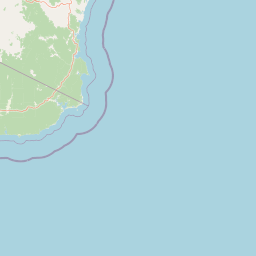
Map view of East Gippsland Commonwealth Marine Reserve

Use this park location map to pinpoint East Gippsland Commonwealth Marine Reserve in Australia, understand its exact geographic position, and read its mapped placement within the surrounding landscape more clearly.

Pigeon | © OpenStreetMap contributors

Location context for East Gippsland Commonwealth Marine Reserve

Victoria
Park atlas

Compare adjacent marine protected areas and regional conservation networks along the coast.

Exploring Parks Near East Gippsland Commonwealth Marine Reserve and Surrounding Waters

Continue browsing other protected areas linked to the regional marine network surrounding East Gippsland Commonwealth Marine Reserve. Compare adjacent oceanic zones and coastal reserves to evaluate broader conservation patterns across south-eastern Australia.
Marine protected areaAustralia
32 km away#1 closest

Northwest

Cape Howe Marine National Park: Victoria's Southeastern Marine Protected Landscape

Rugged coast, Southern Ocean influence, and marine conservation.

Cape Howe Marine National Park offers a protected marine environment at the remote eastern edge of Victoria, Australia. Defined by its dramatic coastal geography, the park features rocky headlands, exposed cliffs, and waters influenced by the powerful Southern Ocean. Established in 2002, this marine protected area contributes to a significant continuum of protected lands, adjacent to terrestrial national parks. Its landscape is shaped by powerful surf and coastal wilderness, providing a unique example of marine conservation where the Australian continent meets the open ocean.

Area
40.5 km²
Established
2002
IUCN
II
Climate
Temperate
National parkAustralia
37 km away#2 closest

Northwest

Croajingolong National Park: A UNESCO World Biosphere Reserve with Dramatic Coastal Geography

Explore Victoria's protected wilderness, mapped coastlines, and diverse ecosystems.

Croajingolong National Park is a key protected area in Victoria, Australia, recognized globally as a UNESCO World Biosphere Reserve. This vast national park offers a detailed look at coastal wilderness, characterized by its extensive sandy beaches, rugged rocky headlands, dynamic dunes, and rich heathland ecosystems. Its position along the Tasman Sea coastline provides significant geographic context, forming a vital part of southeastern Australia's protected landscapes and offering unique opportunities for atlas-driven exploration of its mapped terrain and biodiversity.

Area
883.55 km²
Established
1979
IUCN
II
Relief
Mixed relief
National parkNew South Wales
50 km away#3 closest

North

Beowa National Park: Protected Landscape and Coastal Geography in New South Wales

Mapped terrain and unique erosion sites within this national park.

Delve into the protected landscape of Beowa National Park, situated in the coastal region of New South Wales. This national park showcases a varied terrain, from heathland headlands to eucalypt woodlands, with the visually dramatic Pinnacles erosion gully as a key highlight. Its geographic setting within Twofold Bay provides a compelling focus for atlas exploration of Australia's protected natural areas.

Area
104.86 km²
Established
1971
IUCN
II
Relief
Lowland
Nature reserveNew South Wales
About 53 km away#4 closest

North

Nadgee Nature Reserve: Protected Wilderness and Coastal Geography in New South Wales

Coastal heath, eucalyptus forest, and regional bird habitat

Located at the southeastern edge of the Australian continent, Nadgee Nature Reserve offers a deep look at remote coastal landscapes. The area protects a mix of saltwater wetlands, dense eucalyptus forests, and significant Aboriginal cultural sites along the coast, creating a contiguous protected zone that stretches across state borders into Victorian territory.

Area
206.71 km²
Established
1957
IUCN
Ib
Relief
Lowland
National parkNew South Wales
73 km away#5 closest

Northwest

Mount Imlay National Park: Protected Land Geography and Mapped Boundaries in New South Wales

Explore the geographic context of this Australian national park.

Mount Imlay National Park serves as a significant protected area within New South Wales, providing a focal point for understanding regional geography and mapped natural landscapes. As a national park, its boundaries and terrain offer valuable insights for atlas-based discovery, highlighting Australia's commitment to conserving diverse geographic entities and showcasing its role in the broader national landscape context.

Area
48 km²
Established
1972
IUCN
II
Relief
Mountain
Nature reserveNew South Wales
About 74 km away#6 closest

North

Eagles Claw Nature Reserve: Mapping Coastal Protected Landscapes in New South Wales

Coastal terrain, sea gutters, and penguin nesting habitat

Eagles Claw Nature Reserve is a distinctive protected area on the NSW far south coast, known for its rugged shoreline of sea gutters and low cliffs. The site features dense coastal scrub dominated by bracelet honey myrtle, providing essential nesting shelter for little penguins. This atlas overview details the reserve's topography and its function as a vital coastal sanctuary.

Area
0.01 km²
Established
1986
IUCN
IV
Relief
Lowland
Marine protected areaAustralia
75 km away#7 closest

West

Point Hicks Marine National Park: Protected Marine Landscape and Geographic Context

Explore Victoria's unique transitional marine ecosystems and mapped underwater geography.

Point Hicks Marine National Park represents a crucial marine protected area within Victoria, Australia, safeguarding a unique ecological transition zone. The park's underwater geography features a dynamic interplay of rocky reefs and sandy bottoms, supporting a rich diversity of marine life where species from distinct biogeographic regions overlap. Understanding Point Hicks Marine National Park means exploring its protected marine identity, its mapped underwater landscapes, and its critical role in conserving Australia's warmer eastern marine environments.

Area
40 km²
Established
2002
IUCN
II
Relief
Lowland
National parkNew South Wales
76 km away#8 closest

Northwest

South East Forests National Park: New South Wales National Park Atlas Entry

Mapped landscape and protected area geography.

This canonical MoriAtlas entry for South East Forests National Park provides essential geographic context and details about its status as a national park. Understand the mapped boundaries of this protected landscape within New South Wales, supporting discovery through its regional setting and natural terrain. The focus remains on atlas-style exploration of its geographic identity and conservation significance, devoid of visitor logistics or travel advice.

Area
1,151.77 km²
Established
1997
IUCN
II
Relief
Highland

Common questions about visiting, size, designation, and location context for East Gippsland Commonwealth Marine Reserve

East Gippsland Commonwealth Marine Reserve FAQs for park facts, access, geography, and protected area context

Find quick answers about East Gippsland Commonwealth Marine Reserve, including protected-area facts, park geography, trail and visitor context, and how the park fits into its surrounding country and regional landscape.
MoriAtlas Explorer

Continue Your Protected Areas Search Across the Global Atlas

Deepen your exploration by continuing the structured search for national parks and protected areas worldwide. Utilize the comprehensive filtering capabilities to compare different conservation landscapes and refine your understanding of global park geography. Discover more about the distribution and characteristics of protected natural areas.

Global natural geography