Mori Atlas logo
National parkEl Imposible National Park

Mapping the protected boundaries and regional natural context of El Imposible National Park.

El Imposible National Park: National Park Protected Landscape and Ahuachapán Department Geography

Discover El Imposible National Park, a significant national park situated within El Salvador's Ahuachapán Department. This page serves as a detailed entry point for understanding the park's protected landscape identity, its mapped geographic scope, and its place within regional natural geography. Explore the structured data and atlas context that reveals the core attributes of this protected natural area, facilitating a deeper understanding of its conservation value and landscape significance.

Tropical ForestMountain RangeVolcanic LandscapeWildlife HabitatWatershed ProtectionBirdwatching
Stylized illustration of a mountain valley with waterfall, dense forest, and trees

El Imposible National Park

National park

Park overview

Structured park overview, official facts, and landscape profile for El Imposible National Park

El Imposible National Park park facts, protected area profile, and essential visitor context
Review the core facts for El Imposible National Park, including designation, size, terrain, visitor scale, habitats, and operating context in one park-focused overview.

About El Imposible National Park

El Imposible National Park occupies a critical position in El Salvador's protected area network as one of the few remaining extensive tropical forest preserves in the country. The park lies within the Apaneca Ilamatepec Mountain Range, a volcanic landscape that creates diverse microclimates and habitat conditions within a relatively compact area. The name El Imposible, meaning "The Impossible," refers to the historically dangerous passage through the deep gorge that connects the highland coffee-growing regions to the Pacific port, where the difficult terrain claimed the lives of farmers and their pack animals. Today, the protected forest covers the slopes and valleys that once posed such challenges, preserving the ecological character of this mountainous region. The park's eight rivers represent a vital hydrological system, carrying water from the upper catchments down to the Barra de Santiago estuary and the mangrove forests that line the Pacific coast. This watershed connection makes the park important for both terrestrial and coastal ecosystems. The elevation range from 250 to 1,425 meters supports distinct vegetation zones, from lower elevation tropical forest through to higher elevation cloud forest conditions in the upper reaches.

Quick facts and research context for El Imposible National Park

El Imposible National Park spans 38.20 square kilometers in the Ahuachapán Department of El Salvador, within the Apaneca Ilamatepec volcanic mountain range. The park was established in 1989 and protects tropical forest ecosystems at elevations between 250 and 1,425 meters. Its eight rivers form a critical watershed serving the Barra de Santiago estuary and adjacent coastal mangrove systems. The park was nominated for UNESCO World Heritage status in 1992 alongside the Cara Sucia archaeological site. Notable wildlife includes pumas, oncilla, wild boars, king hawks, and black-crested eagles.

Park context

Deeper park guide and search-rich context for El Imposible National Park

El Imposible National Park history, landscape, wildlife, and travel context
Explore El Imposible National Park through its history, landscape character, ecosystems, wildlife, conservation priorities, cultural context, and seasonal travel timing in a structured park guide built for atlas discovery and search intent.

Why El Imposible National Park stands out

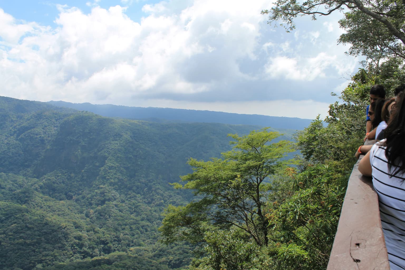
El Imposible National Park is best known for its preservation of pristine tropical forest within a rugged volcanic mountain landscape that was historically impassable for coffee traders. The park protects one of the most ecologically significant forest remnants in El Salvador, supporting populations of pumas, oncilla (a small spotted cat), and black-crested eagles. The dramatic terrain, with its steep gorges and eight river systems descending to the Pacific coast, creates a unique highland-to-coastal ecosystem. From elevated points within the forest, visitors can see the Pacific Ocean, adding to the park's scenic distinction.

Two people standing at a wooden railing overlooking a mountainous forest landscape with green hills and scattered clouds
View from a wooden railing at a lookout point overlooking forested mountains in El Imposible National Park

El Imposible National Park history and protected-area timeline

El Imposible National Park was established on 1 January 1989 as part of El Salvador's expanding protected area system during the late twentieth century. The park's creation reflected growing recognition of the ecological significance of the Apaneca Ilamatepec region's forests, which had been subject to agricultural expansion and coffee cultivation pressures throughout the previous century. The park was named for the historic El Imposible gorge, a notorious passage that farmers and muleteers used when transporting coffee from the highland farms to the Pacific coastal port. The route was considered impossible or extremely hazardous due to the steep terrain, fast-flowing rivers, and the physical dangers posed by the narrow canyon. In 1992, El Imposible was entered on the UNESCO World Heritage Tentative Lists, recognizing its potential global significance as a natural heritage site. This nomination was submitted jointly with the Cara Sucia archaeological site, highlighting the combined natural and cultural heritage value of the broader region.

El Imposible National Park landscape and geographic character

The landscape of El Imposible National Park is defined by the steep, rugged terrain of the Apaneca Ilamatepec volcanic mountain range. Deep valleys and dramatic gorges cut through the volcanic slopes, creating a landscape of considerable topographic complexity. The terrain rises from approximately 250 meters along the lower river corridors to peaks reaching around 1,425 meters above sea level. This substantial elevation range creates diverse environmental conditions across the park. Eight river systems originate in the highland catchment and flow through the park, descending through steep channels before exiting to the coastal plain. These rivers are critical to the hydrological function of the region, feeding the extensive mangrove ecosystem at Barra de Santiago where they meet the Pacific Ocean. From the higher points within the park, the flat expanse of the Pacific Ocean is visible on the horizon, providing a striking visual connection between the volcanic highlands and the coastal marine environment.

El Imposible National Park ecosystems, habitats, and plant life

El Imposible National Park protects one of the most ecologically important tropical forest areas in El Salvador and Central America. The park's position within the Apaneca Ilamatepec range creates a mosaic of habitats across its elevation gradient, supporting significant biodiversity. The tropical forest that covers the park's slopes represents a critical refuge for species in a region where extensive agricultural conversion has dramatically reduced natural forest cover. The watershed function of the eight rivers flowing through the park extends the ecological significance beyond the park boundaries, supporting the coastal mangrove forests and the Barra de Santiago estuary. These mangrove systems are themselves important for coastal protection, fish production, and migratory bird habitat. The combination of highland forest and coastal wetland creates an integrated ecosystem that supports complex ecological processes and species populations that depend on both habitats.

El Imposible National Park wildlife and species highlights

The wildlife community of El Imposible National Park includes several notable species that reflect the park's ecological significance. The park supports populations of pumas, the largest native cat in the region, which require extensive territories and intact forest habitat. The oncilla, a small spotted cat also known as the tigrillo, is present in the park and represents a species of conservation concern throughout its range. Wild boars are found throughout the forested areas, along with various smaller mammals that occupy the forest understory and ground layers. The bird community includes king hawks and black-crested eagles, the latter being a striking raptor that inhabits the forest canopy and open areas. The diverse habitat conditions created by the elevation gradient and the mix of forest types support varied bird communities, from tropical lowland species to higher elevation forest dwellers. The river systems also provide habitat for aquatic species and contribute to the overall biodiversity of the protected area.

El Imposible National Park conservation status and protection priorities

El Imposible National Park represents a key conservation priority for El Salvador and the broader Central American region. The park protects what remains of the extensive tropical forests that once covered the volcanic highlands of western El Salvador, a region that has experienced extensive deforestation for coffee cultivation and agricultural expansion. As an IUCN Category II protected area, the park is managed primarily for ecosystem conservation while allowing for sustainable recreational use. The inclusion of El Imposible on the UNESCO World Heritage Tentative Lists in 1992 reflected international recognition of the park's potential significance as a natural heritage site. The watershed function of the park's rivers, carrying water from the highlands to support coastal mangrove forests and the Barra de Santiago estuary, creates conservation value that extends well beyond the park's boundaries. These mangrove forests are themselves protected and represent important coastal ecosystems that depend on freshwater inputs from the highland catchments.

El Imposible National Park cultural meaning and human context

The cultural landscape of El Imposible National Park is deeply connected to the history of coffee cultivation in the Apaneca Ilamatepec region. The park's name derives from the El Imposible gorge, a passage that was famously dangerous and difficult for farmers transporting coffee beans from the highland fincas to the port facilities on the Pacific coast. The steep terrain and the risk of the route were such that both farmers and pack animals sometimes perished during the journey, creating a name that reflected the physical challenges of moving goods through this landscape. This historical context gives the park a cultural dimension beyond its ecological significance, preserving the memory of a traditional economic activity that shaped the region's development. The area surrounding the park continues to be characterized by coffee farming, and the park itself represents a preserved remnant of the original forest that would have covered the landscape before agricultural expansion.

Top sights and standout views in El Imposible National Park

El Imposible National Park offers visitors the opportunity to explore pristine tropical forest in one of El Salvador's most scenic mountain landscapes. The park's network of trails traverses the varied terrain, allowing hikers to experience the transition from lower elevation forest through to higher elevation vegetation zones. The viewpoints within the park provide sweeping views of the surrounding volcanic landscape and, on clear days, extend to the Pacific Ocean visible on the horizon. The wildlife opportunities, while requiring patience and luck to observe, include the possibility of sighting pumas, oncilla, and black-crested eagles in their natural habitat. The rivers that flow through the park create scenic cascades and pools that add to the landscape's appeal. The combination of forest preservation, watershed protection, and scenic beauty makes El Imposible one of El Salvador's most significant natural areas.

Best time to visit El Imposible National Park

El Imposible National Park can be visited throughout the year, though the optimal period generally falls during the dry season from November through April when precipitation is lower and trail conditions are more favorable for hiking. During the wet season from May to October, rainfall can be heavy and trails may become slippery and difficult to navigate. The park's tropical forest environment means that humidity is consistently high regardless of season. Visiting during the early morning hours offers the best opportunities for wildlife observation, as animals are more active during the cooler parts of the day. The landscape's appearance varies with the seasons, with the forest appearing lush and green during and immediately after the wet season, while the dry season may show more varied coloration as some trees lose leaves. The views toward the Pacific Ocean are clearest during the dry months when atmospheric haze is reduced.

Park location guide

Geography guide, regional context, and park location map for El Imposible National Park

El Imposible National Park park geography, regions, and map view in El Salvador
Understand where El Imposible National Park sits in El Salvador through a broader geographic reading of the surrounding landscape, nearby location context, and its mapped position within the national park landscape.

How El Imposible National Park fits into El Salvador

El Salvador is a presidential republic in Central America. It gained independence from Spain in 1821 and has since experienced periods of political instability, including a civil war from 1979 to 1992. The country uses the US dollar as its currency and is known for its Pacific coastline and volcanic terrain.

Wider geography shaping El Imposible National Park in El Salvador

El Salvador is located in Central America, bordered by Honduras to the northeast, Guatemala to the northwest, and the Pacific Ocean to the south. The country sits along the Pacific Ring of Fire and has volcanic terrain.

Map view of El Imposible National Park

Use this park location map to pinpoint El Imposible National Park in El Salvador, understand its exact geographic position, and read its mapped placement within the surrounding landscape more clearly.

Pigeon | © OpenStreetMap contributors

Location context for El Imposible National Park

Ahuachapán Department

Discover the distinctive habitats and dramatic volcanic terrain through comprehensive protected-area photography.

Exploring El Imposible National Park: Visual Guide to its Tropical Forest Landscapes and Rugged Mountain Scenery
Explore compelling El Imposible National Park photos to visually grasp its rugged volcanic landscapes and vital tropical forest habitats. Reviewing this imagery helps users understand the park's unique geographic character, diverse ecosystems, and the significant role it plays in Central American conservation.

Two people standing at a wooden railing overlooking a mountainous forest landscape with green hills and scattered clouds

Park atlas

Explore Surrounding Tropical Forest Reserves and Mountain Protected Landscapes for Regional Comparison

Discover Other Protected Areas Near El Imposible National Park, El Salvador
Continue your exploration from El Imposible National Park by browsing other national parks and protected areas in El Salvador, tracing the spread of tropical forest, volcanic terrain, and significant watershed regions. Compare conservation landscapes to gain deeper geographic context, expanding your understanding of Central American biodiversity and the unique protected areas beyond a single park.
National parkEl Salvador

El Boquerón National Park: National Park Atlas, Mapped Boundaries, and Regional Geography

Explore El Salvador's protected volcanic terrain and landscape.

Delve into the protected landscape of El Boquerón National Park, a significant national park in El Salvador. This resource provides detailed map context, focusing on the park's geographic boundaries and its position within the country's volcanic region. Understand the atlas-driven discovery value and unique regional setting of this protected area.

Area
2.05 km²
Established
2008
IUCN
II
Relief
Mountain
National parkEl Salvador

Montecristo National Park: El Salvador's Protected Landscape and Geographic Identity

Explore its mapped boundaries and regional terrain.

Montecristo National Park is a vital protected area that anchors a specific geographic identity within El Salvador. This MoriAtlas entry provides an atlas-driven view of the park, highlighting its mapped boundaries and the characteristics of its natural terrain. Understanding Montecristo National Park's protected status offers insight into the region's geography and its place within Central America's broader landscape.

Area
19.73 km²
Established
2008
IUCN
II
Relief
Mixed relief
National parkHonduras

Montecristo Trifinio National Park: Honduras National Park and Protected Landscape Atlas

Explore its mapped boundaries and regional geographic context.

Delve into the protected landscape of Montecristo Trifinio National Park, a designated national park within Honduras. This resource provides critical atlas-level information, detailing the park's geographic scope, mapped boundaries, and its significance as a protected natural area. Understand the terrain and landscape context to appreciate its unique role in the region's conservation framework and its place within the structured exploration of national parks.

Area
54 km²
Established
1987
IUCN
II
Relief
Mountain
National parkLempira Department

Celaque National Park: Mapped Protected Landscape within Lempira Department

National Park Protected Area & Geographic Context

Celaque National Park represents a key protected landscape situated in the Lempira Department of Honduras. This entry offers detailed atlas information, focusing on the park's identity as a national park and its mapped geographic extent. Users can explore the protected boundaries and understand its place within the regional terrain, providing essential context for geographic discovery.

Area
266.31 km²
Established
1987
IUCN
II
Relief
Mountain
National parkHonduras

Cerro Azul de Copán National Park: Honduras's Highland Cloud Forest Protected Area

Explore mapped geography and montane landscape context.

Cerro Azul de Copán National Park, located in the highlands of western Honduras, is a national park defined by its mountainous terrain and distinctive cloud forest environment. Rising to elevations of over 2,200 meters, the park preserves a crucial highland ecosystem known for its biodiversity and role in watershed protection. Its mapped geography offers insight into the unique montane forest structures and the broader natural landscape of Central America. Discover the protected land's specific environmental characteristics and its place within the region's atlas.

Area
154.6 km²
Established
1987
IUCN
II
Relief
Mountain
National parkHonduras

Montaña Santa Bárbara National Park: National Park Geography and Protected Landscape

Mapped boundaries and regional landscape context in Honduras.

Delve into the protected landscape identity of Montaña Santa Bárbara National Park, a significant national park situated in Honduras. This entry provides atlas-focused details on its geographic footprint, mapped terrain, and its role within the nation's protected areas. Understand the park's environmental setting and its importance in the context of Honduran geography for structured exploration.

Area
121.3 km²
Established
1987
IUCN
II
Relief
Mountain
National parkHonduras

Cerro Azul Meámbar National Park: Protected Area and Mapped Landscape Context

Explore its geography and national park boundaries in Honduras.

Cerro Azul Meámbar National Park offers a unique perspective on Honduras's protected lands and national park geography. This entry provides an atlas-style overview of its mapped boundaries and its regional landscape context, crucial for understanding the distribution of conservation areas within Central America. Gain insight into its protected area status and geographic identity for focused landscape discovery.

Area
300 km²
Established
1987
IUCN
II
Relief
Mountain
National parkToledo District

Sarstoon-Temash National Park: National Park Geography and Mapped Boundaries

Explore the protected landscape of Toledo District.

Sarstoon-Temash National Park is a key protected area located in Belize's Toledo District. As a national park, it offers distinct geographic features and mapped boundaries that are crucial for understanding regional conservation landscapes. This entry provides detailed context on its protected status and geographic setting, enabling a more profound atlas-based exploration of the natural terrain and its significance.

Area
165.92 km²
Established
1994
IUCN
II
Relief
Lowland

Common questions about visiting, size, designation, and location context for El Imposible National Park

El Imposible National Park FAQs for park facts, access, geography, and protected area context
Find quick answers about El Imposible National Park, including protected-area facts, park geography, trail and visitor context, and how the park fits into its surrounding country and regional landscape.
MoriAtlas Explorer

Continue Your Protected Areas Search Across the Global Atlas

Deepen your exploration by continuing the structured search for national parks and protected areas worldwide. Utilize the comprehensive filtering capabilities to compare different conservation landscapes and refine your understanding of global park geography. Discover more about the distribution and characteristics of protected natural areas.

Global natural geography