

Mori Atlas logo
National parkEpping Forest National Park

Trace the mapped boundaries and regional setting of this Australian national park.

Epping Forest National Park: Queensland National Park Protected Landscape and Geography

Epping Forest National Park stands as a key protected area within Queensland, Australia, offering a specific focus for national park atlas exploration. This page details the park's identity as a designated national park, providing essential geographic context within the northeastern Australian landscape. Users can investigate its mapped boundaries and understand its place within the broader regional geography of Queensland, facilitating a structured discovery of Australia's protected natural areas.

Strict Nature ReserveQueenslandWombat ConservationEndangered SpeciesEucalypt WoodlandBrigalow Belt

Epping Forest National Park

National park

Park overview

Structured park overview, official facts, and landscape profile for Epping Forest National Park

Epping Forest National Park park facts, protected area profile, and essential visitor context
Review the core facts for Epping Forest National Park, including designation, size, terrain, visitor scale, habitats, and operating context in one park-focused overview.

About Epping Forest National Park

Epping Forest National Park represents one of Australia's most specialised and significant protected areas, functioning as the last refuge for a mammal on the brink of extinction. Located in central Queensland's brigalow belt landscape, the park was established in 1971 specifically to conserve the northern hairy-nosed wombat, a species that has persisted through tens of thousands of years of Australian environmental change but now faces imminent extinction pressures. The park's strict protection status reflects its singular conservation mission: unlike typical national parks that welcome visitors, Epping Forest remains closed to the public to minimise any disturbance to its vulnerable resident species. The Queensland Parks and Wildlife Service manages the site as a scientific research facility, allowing carefully controlled access only for researchers conducting essential population studies and monitoring activities. The park sits within the Drummond Basin, a geological region known for its ancient landscape features, and falls within the Belyando River water catchment area, linking its hydrological systems to broader regional ecosystem functions.

Quick facts and research context for Epping Forest National Park

Epping Forest National Park is a strict nature reserve in central Queensland, established in 1971 to protect the endangered northern hairy-nosed wombat. The park covers 31.60 square kilometres within the Brigalow Belt North bioregion, situated around 855 kilometres northwest of Brisbane near Clermont. As an IUCN Category Ia protected area, it is closed to the general public and accessible only to scientists, rangers, and authorised volunteers. The northern hairy-nosed wombat, the world's largest burrowing herbivore, is the flagship species driving all conservation management at the site. The park supports 251 animal species and 103 plant species across its eucalypt woodland and sandy soil environments.

Park context

Deeper park guide and search-rich context for Epping Forest National Park

Epping Forest National Park history, landscape, wildlife, and travel context
Explore Epping Forest National Park through its history, landscape character, ecosystems, wildlife, conservation priorities, cultural context, and seasonal travel timing in a structured park guide built for atlas discovery and search intent.

Why Epping Forest National Park stands out

Epping Forest National Park is renowned globally for being the sole remaining natural habitat of the northern hairy-nosed wombat (Lasiorhinus krefftii), the world's largest burrowing herbivore and one of Australia's most critically endangered mammals. This strict nature reserve is the only place where this species survives in the wild, making it indispensable for the species' survival. The park's significance extends beyond its borders as a living laboratory for understanding wombat ecology, population dynamics, and conservation requirements. The 2007 census recorded approximately 138 individuals, a remarkable recovery from the dangerously low population of just 20 to 30 individuals in the 1970s.

Epping Forest National Park history and protected-area timeline

The establishment of Epping Forest National Park in 1971 marked a critical turning point in the conservation of the northern hairy-nosed wombat, a species that had been pushed to the brink of extinction by habitat loss, competition from introduced species, and other pressures of European settlement. Prior to formal protection, the wombat population had declined catastrophically, with estimates in the 1970s suggesting only 20 to 30 individuals remained in the wild. This alarmingly low population prompted urgent conservation action, leading to the creation of the reserve specifically designed to provide secure habitat for the remaining wombats. The park's designation as an IUCN Category Ia strict nature reserve reflects the highest level of protection, recognising that even minimal human disturbance could jeopardise the species' survival. Ongoing census work, including the 2007 population estimate of approximately 138 individuals, demonstrates that the conservation strategy has achieved meaningful results, though the species remains critically endangered and dependent on the park's continued protection.

Epping Forest National Park landscape and geographic character

The terrain within Epping Forest National Park consists largely of eucalypt woodland that dominates the flat to gently undulating landscape at an elevation of approximately 230 metres above sea level. The vegetation community provides the essential structural habitat that supports the northern hairy-nosed wombat and other resident species. Of particular significance are the patches of sandy soils scattered throughout the park, which serve as the critical resource enabling wombats to construct their extensive burrow systems. These burrowing sites are essential for the wombats' survival, providing shelter from temperature extremes, protection from predators, and suitable breeding habitat. The sandy substrate contrasts with the surrounding heavier soils typical of the brigalow belt, making these pockets of suitable soil strategically important across the park's extent. The landscape lacks prominent topographic features but maintains the characteristic dry woodland appearance of central Queensland's semi-arid inland regions.

Epping Forest National Park ecosystems, habitats, and plant life

Epping Forest National Park sits within the Brigalow Belt North bioregion, a landscape character defined by extensive eucalypt woodlands interspersed with brigalow shrubland and various grassy understory communities. The park's ecological significance stems directly from its role as the sole remaining natural habitat for the northern hairy-nosed wombat, but the protected area also supports broader biodiversity across its 31.6 square kilometre extent. The park hosts 251 animal species and 103 plant species, creating a surprisingly diverse ecological community within what might appear to be a relatively restricted landscape. The eucalypt woodland provides essential resources including hollow-bearing trees for other fauna, nectar and pollen sources for insects and birds, and leaf litter supporting soil invertebrate communities. The undisturbed nature of the reserve, maintained through its strict access controls, allows natural ecological processes to continue with minimal human interference, supporting the complex interactions upon which the wombat population depends.

Epping Forest National Park wildlife and species highlights

The wildlife community within Epping Forest National Park centres on the northern hairy-nosed wombat (Lasiorhinus krefftii), a species that represents the park's entire conservation rationale. This remarkable marsupial is the world's largest burrowing herbivore, weighing considerably more than other wombat species and capable of constructing extensive underground tunnel systems. The 2007 census documented approximately 138 individuals within the park, representing essentially the entire wild population of this critically endangered species. Beyond the flagship wombat, the park's 251 recorded animal species include various mammals, birds, reptiles, and invertebrates that share the eucalypt woodland habitat. The sandy soil burrowing areas support not only wombats but also provide habitat for other digging species, while the woodland canopy and understory support arboreal and ground-dwelling fauna appropriate to the brigalow belt ecosystem.

Epping Forest National Park conservation status and protection priorities

Epping Forest National Park represents one of the most concentrated conservation priorities in Australian protected area management due to its role as the last refuge for the northern hairy-nosed wombat. The species was driven to near extinction in the wild prior to the park's establishment, with population estimates as low as 20 to 30 individuals in the 1970s. The creation of a strict nature reserve with minimal human disturbance proved essential to allowing the population to stabilise and begin recovering. The park's IUCN Category Ia designation reflects its function as a strict nature reserve where ecosystem processes are allowed to continue essentially unmodified by human activity. Ongoing research and monitoring programmes continue to inform conservation management, with population surveys providing crucial data on whether the recovery trend is being maintained. The survival of this species outside captivity depends entirely on the protection afforded by Epping Forest, making every aspect of the park's management critical to preventing the extinction of one of Australia's most distinctive mammals.

Top sights and standout views in Epping Forest National Park

Epping Forest National Park's primary highlight is its role as the exclusive natural habitat of the northern hairy-nosed wombat, the world's largest burrowing herbivore and one of Australia's most endangered mammals. The strict protection regime that closes the park to public visitors is itself notable, as this approach prioritises species survival over visitor access, a rare management philosophy among national parks globally. The successful stabilisation and growth of the wombat population from a critical low of 20 to 30 individuals in the 1970s to approximately 138 by 2007 demonstrates that focused conservation can produce measurable results. The park also represents the brigalow belt bioregion's conservation heritage, protecting a representative sample of this distinct Queensland landscape type and its associated biodiversity beyond the wombat focus species.

Best time to visit Epping Forest National Park

As a strict nature reserve closed to the general public, the concept of visiting Epping Forest National Park does not apply in the conventional sense. Access is restricted to scientists conducting research, Queensland Parks and Wildlife Service rangers, and authorised volunteers. For those undertaking approved research or management activities, the optimal timing would generally align with cooler, drier periods typical of Queensland's winter and autumn months, when extreme heat is less likely to affect both researchers and wildlife. However, seasonal considerations are secondary to the strict access controls that govern all entry to the reserve, with any visits requiring prior authorisation from the managing authority.
Park location guide

Geography guide, regional context, and park location map for Epping Forest National Park

Epping Forest National Park park geography, regions, and map view in Australia
Understand where Epping Forest National Park sits in Australia through a broader geographic reading of the surrounding landscape, nearby location context, and its mapped position within the national park landscape.

How Epping Forest National Park fits into Australia

Australia is a constitutional monarchy and federal parliamentary democracy comprising six states and ten territories. With a population of nearly 28 million, it is one of the world's most urbanised countries, with most people concentrated on the eastern seaboard. The country has a high Human Development Index and is known for its cultural diversity, ancient Aboriginal heritage, and unique wildlife.

Wider geography shaping Epping Forest National Park in Australia

Australia occupies the entire Australian continent, the island of Tasmania, and numerous smaller islands. It is the world's flattest and driest inhabited continent, featuring vast deserts in the interior (the Outback), tropical rainforests along the eastern coast, and a coastline bordering the Indian and Pacific Oceans.

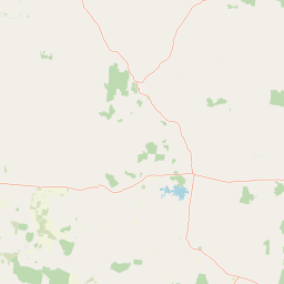
Map view of Epping Forest National Park

Use this park location map to pinpoint Epping Forest National Park in Australia, understand its exact geographic position, and read its mapped placement within the surrounding landscape more clearly.

Pigeon | © OpenStreetMap contributors

Location context for Epping Forest National Park

Queensland
Park atlas

Discover surrounding conservation landscapes and compare other protected areas across Queensland, Australia, for deeper geographic context.

Explore National Parks and Protected Areas Near Epping Forest National Park, Queensland, Australia
Continue your exploration beyond Epping Forest National Park by browsing a curated list of national parks and other protected areas across Queensland, Australia. This allows you to compare diverse conservation landscapes, map regional protected area distributions, and trace the geographic context of similar eucalypt woodland ecosystems.
National parkQueensland

Mazeppa National Park: Queensland's Semi-Arid Gidgee Scrub Protected Landscape

Explore mapped boundaries of this Central Queensland national park.

Mazeppa National Park preserves critical examples of semi-arid gidgee scrub, a vegetation type significantly reduced across inland Queensland. This protected woodland ecosystem, situated in Central Queensland, offers a glimpse into the region's natural heritage with its characteristic terrain of gently undulating plains and dense gidgee tree stands. Discover its mapped geographic context and the unique outback landscape identity that makes it a noteworthy conservation area among Australia's national parks.

Area
41.3 km²
Established
1972
IUCN
II
Scope
Terrestrial
National parkQueensland

Narrien Range National Park: Queensland's Protected Landscape for Geographic Exploration

Understand its mapped terrain and regional park context.

Narrien Range National Park represents a vital protected landscape within Queensland, Australia, offering a deep dive into regional geography and conservation lands. As a designated national park, it serves as a crucial point for atlas-based exploration, detailing its specific mapped boundaries and ecological context. Understanding Narrien Range National Park means appreciating its contribution to the diverse natural geography of northeastern Australia, providing a concrete example of protected land within the Sunshine State.

Area
40.2 km²
IUCN
II
Access
Access unknown
Scope
Terrestrial
National parkQueensland

Cudmore National Park: Mapped Protected Area in Queensland's Geography

Explore the unique landscape and regional context.

Cudmore National Park represents a distinct protected landscape within the vast geographic expanse of Queensland, Australia. This national park offers a valuable point of entry for understanding regional conservation efforts and the mapped distribution of protected lands. Examine its specific location within Queensland's natural terrain and appreciate its role in the broader atlas of Australian protected areas, focusing on its geographic identity and landscape features.

Area
204 km²
Established
1998
IUCN
II
Climate
Arid
National parkQueensland

Blackwood National Park: Queensland National Park Protected Landscape and Geography

Mapped protected area boundaries in northeastern Australia.

Blackwood National Park, identified as a national park, offers a distinct protected landscape within Queensland's expansive geography. This entry focuses on its specific mapped boundaries and its role as a conservation area in northeastern Australia. Users can delve into the park's geographic context, understanding its significance as part of Queensland's diverse natural heritage and contributing to a comprehensive atlas of protected lands in the region.

Area
16 km²
Established
1991
IUCN
II
Relief
Upland
National parkQueensland

Peak Range National Park: Mapped Protected Landscape and Regional Geography in Queensland

Explore Queensland's protected areas and natural terrain context.

Peak Range National Park is presented here as a key protected landscape within the diverse geography of Queensland, Australia. Users can explore its specific mapped boundaries and understand its regional setting, contributing to a structured overview of natural areas. This provides essential geographic context and supports deeper atlas-based discovery of Queensland's protected lands and varied terrain.

Area
25 km²
Established
1983
IUCN
II
Relief
Mountain
National parkQueensland

Forest Den National Park: Queensland's Protected Landscape and Geographic Atlas

Explore mapped boundaries and regional park geography.

Forest Den National Park stands as a distinct protected landscape within Queensland, Australia. This MoriAtlas entry provides detailed geographic context, focusing on the park's mapped boundaries and its position within the regional atlas. Discover the specific terrain and landscape characteristics that define this national park, aiding in structured geographic exploration and understanding its protected status within northeastern Australia.

Area
58.9 km²
Established
1991
IUCN
II
Relief
Upland
National parkQueensland

Snake Range National Park: Queensland Protected Area and Landscape Mapping

Explore the geographic boundaries and natural terrain.

Snake Range National Park is a significant protected national park entity within Queensland, Australia. This detailed entry provides essential geographic context, focusing on the park's mapped boundaries, its role as a conservation landscape, and its integration into the wider regional geography. For users interested in atlas exploration, understanding the specific natural terrain and protected area distribution of Snake Range National Park is paramount.

Area
26.88 km²
Established
1972
IUCN
II
Relief
Mountain
National parkQueensland

Moorrinya National Park: Queensland Protected Landscape Exploration

Mapped boundaries and regional park geography.

Moorrinya National Park represents a distinct protected landscape within Queensland, Australia, offering valuable insights into the region's natural terrain and geographic distribution of conservation areas. This national park serves as a focal point for understanding local environmental context and the broader atlas of Australian protected lands. Delve into the mapped outlines and regional setting to grasp its unique ecological position.

Area
326.07 km²
Established
1993
IUCN
II
Scope
Terrestrial

Common questions about visiting, size, designation, and location context for Epping Forest National Park

Epping Forest National Park FAQs for park facts, access, geography, and protected area context
Find quick answers about Epping Forest National Park, including protected-area facts, park geography, trail and visitor context, and how the park fits into its surrounding country and regional landscape.
MoriAtlas Explorer

Continue Your Protected Areas Search Across the Global Atlas

Deepen your exploration by continuing the structured search for national parks and protected areas worldwide. Utilize the comprehensive filtering capabilities to compare different conservation landscapes and refine your understanding of global park geography. Discover more about the distribution and characteristics of protected natural areas.

Global natural geography