

Mori Atlas logo
National parkPeak Range National Park

Discover the mapped boundaries and regional landscape context of this Queensland national park.

Peak Range National Park: A Protected Landscape within Queensland's Diverse Geography

Peak Range National Park stands as a significant protected area within Queensland, Australia. This page offers an atlas-centric view, focusing on the park's geographic identity and its role as a mapped natural landscape. Explore its protected boundaries and understand its place within the broader regional geography of northeastern Australia, providing foundational data for landscape context and protected-area discovery.

National ParkCentral QueenslandBrigalow BeltProtected AreaKoala HabitatRare Species

Peak Range National Park

National park

Park overview

Structured park overview, official facts, and landscape profile for Peak Range National Park

Peak Range National Park park facts, protected area profile, and essential visitor context
Review the core facts for Peak Range National Park, including designation, size, terrain, visitor scale, habitats, and operating context in one park-focused overview.

About Peak Range National Park

Peak Range National Park is located in Central Queensland, Australia, within the Brigalow Belt bioregion—a geographically and ecologically distinct region that spans inland areas of the state. The park sits approximately 760 kilometres northwest of Brisbane, placing it in a remote inland position far from Queensland's more famous coastal landscapes. Despite its modest size of 25 square kilometres, the protected area serves as an important node in Queensland's network of conservation reserves, providing habitat protection for species that have declined across broader landscape areas. The Brigalow Belt bioregion is characterised by its rolling terrain, semi-open woodlands, and vegetation communities adapted to the region's climate patterns. The park's establishment in 1983 reflects Queensland's efforts during that period to expand protected area coverage across ecologically significant but lesser-known inland regions. The Queensland Parks and Wildlife Service maintains management responsibility for the reserve, focusing on habitat preservation and species protection within this defined landscape.

Quick facts and research context for Peak Range National Park

Peak Range National Park covers 25 square kilometres in Central Queensland's Brigalow Belt bioregion, approximately 760 kilometres inland from Brisbane. The park was formally established in 1983 under the IUCN Category II classification for national parks. It is governed by the Queensland Parks and Wildlife Service and is located near the town of Dysart. The protected area is notable for containing two rare threatened plant species and two animal species of conservation significance, making it an important small reserve in Queensland's protected area network.

Park context

Deeper park guide and search-rich context for Peak Range National Park

Peak Range National Park history, landscape, wildlife, and travel context
Explore Peak Range National Park through its history, landscape character, ecosystems, wildlife, conservation priorities, cultural context, and seasonal travel timing in a structured park guide built for atlas discovery and search intent.

Why Peak Range National Park stands out

Peak Range National Park is best known for its conservation significance within the Brigalow Belt bioregion, protecting two rare threatened plant species, Trioncinia patens and Dichanthium queenslandicum, along with notable animal species including the koala and the partridge pigeon (Geophaps scripta scripta). The park represents a relatively rare example of protected Brigalow Belt habitat, a biome that has faced substantial clearing and modification across its historical range. This small reserve provides a critical sanctuary for species that depend on the specific woodland and open forest environments found in this Central Queensland bioregion.

Peak Range National Park history and protected-area timeline

Peak Range National Park was established in 1983 as part of Queensland's expanding national park system during the late twentieth century. The park's creation reflected growing recognition of the conservation value held by areas within the Brigalow Belt bioregion, a region that had experienced significant land clearing for agricultural purposes throughout the preceding decades. The formal protection of this area provided a designated conservation reserve for the rare and endemic species found within its boundaries. The park was assigned IUCN Category II status, classification for national parks, indicating its primary purpose of protecting natural ecosystems while allowing for sustainable visitor use where appropriate. Management responsibility was delegated to the Queensland Parks and Wildlife Service, which continues to oversee the reserve's conservation objectives. The park's establishment represented a targeted effort to preserve representative examples of Brigalow Belt habitats that were becoming increasingly rare across Queensland's inland areas.

Peak Range National Park landscape and geographic character

The landscape of Peak Range National Park reflects the characteristic terrain of the Brigalow Belt bioregion in Central Queensland. The area features rolling hills and undulating terrain typical of this inland region, with elevations and topography that create a sense of subtle elevation change across the landscape. The vegetation consists primarily of open woodland environments, with the characteristic brigalow (Acacia harpophylla) and associated eucalyptus species forming the dominant canopy. The underlying geology consists of ancient sedimentary formations consistent with the broader Central Queensland landscape. The terrain supports drainage patterns typical of semi-inland Queensland, with vegetation communities adapted to seasonal climate variations. The park's landscape, while not dramatic in the sense of dramatic mountain or coastal scenery, represents a distinctive Australian inland terrain type that has become increasingly scarce due to broad-scale land use changes across the Brigalow Belt region.

Peak Range National Park ecosystems, habitats, and plant life

The nature of Peak Range National Park is defined by its position within the Brigalow Belt bioregion, a distinct ecological area that spans inland Queensland and encompasses a transition between tropical and more temperate environmental influences. The park's vegetation communities include brigalow woodland associations and eucalyptus-dominated open forests, representing the characteristic plant assemblages of this bioregion. These woodland environments provide important habitat structure for multiple species groups, creating a layered canopy and ground layer that supports ecological complexity. The conservation significance of the park's natural values stems from the broader context of the Brigalow Belt, which has experienced substantial vegetation clearing for agriculture and grazing, making protected remnants like Peak Range increasingly valuable for biodiversity persistence.

Peak Range National Park wildlife and species highlights

Peak Range National Park supports several wildlife species of conservation significance, contributing to its importance as a protected area. The park provides habitat for the koala (Phascolarctos cinereus), an iconic Australian marsupial that depends on suitable eucalyptus woodland habitat across its range. Additionally, the park contains the partridge pigeon (Geophaps scripta scripta), a bird species of conservation concern that inhabits forested and woodland areas in eastern Australia. The two threatened plant species found within the park—Trioncinia patens and Dichanthium queenslandicum—represent botanical values that contribute to the park's conservation significance. These species reflect the park's role in protecting endemic plants that are restricted to specific habitat types within the Brigalow Belt. The combination of rare flora and notable fauna makes this small park a meaningful conservation area within Queensland's protected area network.

Peak Range National Park conservation status and protection priorities

Peak Range National Park holds conservation significance disproportionate to its modest 25-square-kilometre area due to the species and habitat types it protects. The park contains two plant species listed as rare or threatened—Trioncinia patens and Dichanthium queenslandicum—reflecting the vulnerability of endemic flora within the Brigalow Belt. Similarly, the presence of koalas and partridge pigeons adds faunal conservation value, as both species face population pressures across their respective ranges. The Brigalow Belt bioregion has suffered extensive habitat loss from agricultural development, making remaining protected areas like Peak Range increasingly important as refuges for biodiversity. The park functions as a conservation island within a modified landscape, providing protected habitat for species that have declined across broader areas of Central Queensland.

Peak Range National Park cultural meaning and human context

The cultural context of Peak Range National Park is not extensively documented in available source materials regarding the park's natural values and management. The Brigalow Belt region has historical associations with Aboriginal peoples, though specific cultural connections to the Peak Range area are not detailed in available Wikipedia content. The park's establishment in 1983 reflects modern conservation governance rather than indigenous protected area management traditions. No specific cultural heritage sites or traditional owner information is provided in the source material, indicating that this aspect of the park's identity would require additional research beyond the available information.

Top sights and standout views in Peak Range National Park

Peak Range National Park's highlights centre on its role as a conservation refuge for rare species within the Brigalow Belt, a bioregion that has experienced substantial habitat loss. The park protects the threatened Trioncinia patens and Dichanthium queenslandicum plants, along with providing habitat for koalas and partridge pigeons. Its location in Central Queensland, approximately 760 kilometres from Brisbane, offers visitors an inland wilderness experience distinct from Queensland's famous coastal parks. The compact size of the reserve makes it accessible for targeted nature observation, while its protected status ensures the preservation of representative Brigalow Belt habitat.

Best time to visit Peak Range National Park

The best time to visit Peak Range National Park would align with Queensland's cooler, drier seasons, typically from autumn through to early spring, when temperatures are more comfortable for outdoor exploration and the landscape conditions are stable. The Central Queensland climate experiences warm to hot conditions during summer months, which may limit visitor comfort and increase fire risk within the protected area. Visiting during the cooler months allows for more pleasant walking and wildlife observation conditions, particularly for viewing species like koalas that may be more active during moderate temperatures. The dry season generally provides more predictable conditions for park visits, though visitors should check current conditions and any access advisories before planning trips to this remote Central Queensland location.
Park location guide

Geography guide, regional context, and park location map for Peak Range National Park

Peak Range National Park park geography, regions, and map view in Australia
Understand where Peak Range National Park sits in Australia through a broader geographic reading of the surrounding landscape, nearby location context, and its mapped position within the national park landscape.

How Peak Range National Park fits into Australia

Australia is a constitutional monarchy and federal parliamentary democracy comprising six states and ten territories. With a population of nearly 28 million, it is one of the world's most urbanised countries, with most people concentrated on the eastern seaboard. The country has a high Human Development Index and is known for its cultural diversity, ancient Aboriginal heritage, and unique wildlife.

Wider geography shaping Peak Range National Park in Australia

Australia occupies the entire Australian continent, the island of Tasmania, and numerous smaller islands. It is the world's flattest and driest inhabited continent, featuring vast deserts in the interior (the Outback), tropical rainforests along the eastern coast, and a coastline bordering the Indian and Pacific Oceans.

Map view of Peak Range National Park

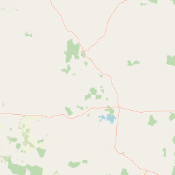
Use this park location map to pinpoint Peak Range National Park in Australia, understand its exact geographic position, and read its mapped placement within the surrounding landscape more clearly.

Pigeon | © OpenStreetMap contributors

Location context for Peak Range National Park

Queensland
Park atlas

Browse the Brigalow Belt's conservation landscapes and trace the regional spread of protected areas surrounding Peak Range National Park.

Find More National Parks and Protected Areas Near Peak Range National Park in Central Queensland
Beyond Peak Range National Park, explore additional national parks and protected areas within Central Queensland, mapping their unique geographical features and conservation objectives. Compare these diverse protected landscapes to understand the broader ecological patterns and conservation efforts across the Brigalow Belt bioregion and beyond.
National parkQueensland

Mazeppa National Park: Queensland's Semi-Arid Gidgee Scrub Protected Landscape

Explore mapped boundaries of this Central Queensland national park.

Mazeppa National Park preserves critical examples of semi-arid gidgee scrub, a vegetation type significantly reduced across inland Queensland. This protected woodland ecosystem, situated in Central Queensland, offers a glimpse into the region's natural heritage with its characteristic terrain of gently undulating plains and dense gidgee tree stands. Discover its mapped geographic context and the unique outback landscape identity that makes it a noteworthy conservation area among Australia's national parks.

Area
41.3 km²
Established
1972
IUCN
II
Scope
Terrestrial
National parkQueensland

Dipperu National Park: Queensland's Protected Natural Landscape and Geographic Atlas

Mapped boundaries and regional terrain within this Australian national park.

Dipperu National Park represents a significant protected landscape within Queensland, Australia, offering a deep dive into its national park identity and geographic setting. This entry provides detailed atlas-oriented information on its mapped boundaries, natural terrain, and its role in the regional geography of northeastern Australia. Users can explore its distinct landscape characteristics and understand its conservation significance through a structured geographic lens, complementing the broader atlas of protected areas.

Area
111 km²
Established
1969
IUCN
Ia
Relief
Lowland
National parkQueensland

Narrien Range National Park: Queensland's Protected Landscape for Geographic Exploration

Understand its mapped terrain and regional park context.

Narrien Range National Park represents a vital protected landscape within Queensland, Australia, offering a deep dive into regional geography and conservation lands. As a designated national park, it serves as a crucial point for atlas-based exploration, detailing its specific mapped boundaries and ecological context. Understanding Narrien Range National Park means appreciating its contribution to the diverse natural geography of northeastern Australia, providing a concrete example of protected land within the Sunshine State.

Area
40.2 km²
IUCN
II
Access
Access unknown
Scope
Terrestrial
National parkQueensland

Junee National Park National Park: Understanding its Protected Landscape in Queensland

Explore mapped boundaries and regional geography within Queensland.

Junee National Park is identified as a protected national park within the Australian state of Queensland. This entry provides essential details for understanding its specific location, its role within the regional geography of northeastern Australia, and its contribution to the nation's atlas of protected landscapes. Focus is placed on its identity as a distinct protected area, offering context for its mapped boundaries and its place within the broader natural terrain of Queensland. Discover the park's geographic significance and its contribution to conservation landscapes.

Area
54 km²
Established
2000
Access
Access unknown
Scope
Terrestrial
National parkQueensland

Epping Forest National Park: Queensland National Park Protected Landscape Identity

Explore its mapped boundaries and regional geography.

Delve into the protected landscape of Epping Forest National Park, a designated national park situated in Queensland, Australia. This entry provides critical atlas-level information, focusing on the park's geographic setting and its role within the regional landscape. Understand its precise location, mapped protected area boundaries, and its contribution to the natural geography of northeastern Australia, offering a factual basis for geographic discovery.

Area
31.6 km²
Established
1971
IUCN
Ia
Relief
Lowland
National parkIsaac Region

Homevale National Park: Central Queensland's Protected Sandstone and Fossil Landscape

Explore dramatic cliffs, peaks, and ancient Permian fossil sites.

Homevale National Park in Australia's Isaac Region is a testament to geological time and conservation. Its landscape is defined by striking sandstone formations, including dramatic cliffs, rugged peaks, and distinctive spires. Beyond its visual appeal, the park is scientifically vital for its Permian-period fossil discoveries, dating back 280 to 225 million years. This protected area offers a unique glimpse into ancient marine environments and the geological evolution of Central Queensland, making it a key destination for atlas-driven landscape discovery.

Area
218 km²
Established
1995
IUCN
II
Relief
Mountain
National parkQueensland

Blackwood National Park: Queensland National Park Protected Landscape and Geography

Mapped protected area boundaries in northeastern Australia.

Blackwood National Park, identified as a national park, offers a distinct protected landscape within Queensland's expansive geography. This entry focuses on its specific mapped boundaries and its role as a conservation area in northeastern Australia. Users can delve into the park's geographic context, understanding its significance as part of Queensland's diverse natural heritage and contributing to a comprehensive atlas of protected lands in the region.

Area
16 km²
Established
1991
IUCN
II
Relief
Upland
National parkQueensland

Cudmore National Park: Mapped Protected Area in Queensland's Geography

Explore the unique landscape and regional context.

Cudmore National Park represents a distinct protected landscape within the vast geographic expanse of Queensland, Australia. This national park offers a valuable point of entry for understanding regional conservation efforts and the mapped distribution of protected lands. Examine its specific location within Queensland's natural terrain and appreciate its role in the broader atlas of Australian protected areas, focusing on its geographic identity and landscape features.

Area
204 km²
Established
1998
IUCN
II
Climate
Arid

Common questions about visiting, size, designation, and location context for Peak Range National Park

Peak Range National Park FAQs for park facts, access, geography, and protected area context
Find quick answers about Peak Range National Park, including protected-area facts, park geography, trail and visitor context, and how the park fits into its surrounding country and regional landscape.
MoriAtlas Explorer

Continue Your Protected Areas Search Across the Global Atlas

Deepen your exploration by continuing the structured search for national parks and protected areas worldwide. Utilize the comprehensive filtering capabilities to compare different conservation landscapes and refine your understanding of global park geography. Discover more about the distribution and characteristics of protected natural areas.

Global natural geography