Mori Atlas logo
State or regional parkEsmeralda Provincial Park

Mapping the rugged subtropical landscapes and forest corridors of Misiones Province, Argentina

Esmeralda Provincial Park: A Protected Core of Alto Parana Atlantic Forest Geography

(Parque Provincial Esmeralda)

Esmeralda Provincial Park encompasses a substantial block of rugged, subtropical forest within the Misiones Province of northeastern Argentina. As the designated core zone of the Yaboti Biosphere Reserve, this protected area preserves the structural complexity of the Alto Parana Atlantic forests. The park acts as a keystone node in transboundary conservation efforts, connecting forested terrain across the Upper Parana region through its steep ridges, forested valleys, and the extensive basin of the Yaboti Guazu stream.

atlantic forestalto parana forestsubtropical forestmisionesprovincial parkbiosphere reserve core

Esmeralda Provincial Park

State or regional park

Park overview

Structured park overview, official facts, and landscape profile for Esmeralda Provincial Park

Esmeralda Provincial Park park facts, protected area profile, and essential visitor context

Review the core facts for Esmeralda Provincial Park, including designation, size, terrain, visitor scale, habitats, and operating context in one park-focused overview.

About Esmeralda Provincial Park

Esmeralda Provincial Park protects a significant block of the Alto Parana Atlantic forests in the Misiones province of northeastern Argentina, an area long recognized for its exceptional but heavily threatened biodiversity. The park lies in the San Pedro department, not far from the town of San Pedro, and encompasses a rugged landscape dominated by subtropical forest, steep terrain, and the drainage basin of the Arroyo Yaboti Guazu. Its accessibility is limited precisely because of this terrain, which has helped shield the interior from the kind of exploitation that reduced many surrounding forests.

The park was originally established as the Obraje Esmeralda Protected Nature Area through provincial legislation in the early 1990s, building on the legacy of a former forestry operation whose name the area still carries. In 1997, provincial law formally elevated the area to a provincial park, redefining it as a strict conservation unit rather than a managed resource area. Around the same period, the park was designated as the natural core, or nucleus zone, of the Yaboti Biosphere Reserve, embedding it within a larger framework of landscape-scale conservation in the Upper Parana region.

Beyond its local conservation role, Esmeralda Provincial Park has come to be seen as a strategic node in broader regional connectivity planning. It is positioned as part of the proposed Trinational Biodiversity Corridor that would link protected forest areas in Brazil, Paraguay, and Argentina, allowing species movements and ecological processes to persist across national boundaries. Its relative size, ecological integrity, and biological station infrastructure make it one of the more important forested reserves in the southern Alto Parana system.

The scientific dimension of the park is significant. The Marcio Ayres Biological Station, established in the early 2000s, provides basic facilities for researchers working on the biodiversity of the Parana forest. Studies conducted from this station have documented a wide array of mammals, birds, and insects, contributing to the broader understanding of what Alto Parana Atlantic forest ecosystems can still support when given protection. This combination of intact habitat and active research infrastructure reinforces the park's status as both a refuge and a reference site for forest conservation in Misiones.

Quick facts and research context for Esmeralda Provincial Park

Esmeralda Provincial Park is located in the San Pedro department of Misiones province, in northeastern Argentina, near the town of San Pedro. It is classified as a provincial park under IUCN Category II and covers roughly 31,600 hectares of protected land in the Alto Parana Atlantic forests ecoregion.

The park was established in 1997 through provincial law and serves as the core or nucleus zone of the Yaboti Biosphere Reserve. It protects the basin of the Arroyo Yaboti Guazu and contains the Marcio Ayres Biological Station, a research facility supporting biodiversity science. The park is also positioned as a critical node within the proposed Trinational Biodiversity Corridor connecting conservation units across Argentina, Paraguay, and Brazil.

Protection and recognition

Examine the documented conservation framework and territorial designation details

Esmeralda Provincial Park Protection Status and Management Scope

Terrestrial protection records define the conservation framework established across Esmeralda Provincial Park. Documented management scope and formal designation metrics outline the administrative status governing this protected area.

Protection details

Protection scope
Terrestrial
Transboundary protection
No
Park context

Deeper park guide and search-rich context for Esmeralda Provincial Park

Esmeralda Provincial Park history, landscape, wildlife, and travel context

Explore Esmeralda Provincial Park through its history, landscape character, ecosystems, wildlife, conservation priorities, cultural context, and seasonal travel timing in a structured park guide built for atlas discovery and search intent.

Why Esmeralda Provincial Park stands out

Esmeralda Provincial Park is best known for protecting one of the largest remaining tracts of Alto Parana Atlantic forest in Misiones province, including the upper basin of the Yaboti Guazu stream. It stands out as the designated core zone of the Yaboti Biosphere Reserve, giving it a central role in regional conservation planning rather than functioning merely as an isolated local reserve. The park is also distinguished by its combination of rugged terrain, dense mixed subtropical forest, and an established scientific research presence through the Marcio Ayres Biological Station. Its integration into proposals for a Trinational Biodiversity Corridor between Argentina, Paraguay, and Brazil further reinforces its identity as a strategically important forest reserve within the Upper Parana landscape.

Esmeralda Provincial Park history and protected-area timeline

The origins of Esmeralda Provincial Park lie in a former forestry operation known as the Obraje Esmeralda, which historically exploited timber in what is now the protected area. Recognizing the ecological value of this landscape, the province of Misiones first granted it protected status as the Obraje Esmeralda Protected Nature Area through provincial law 2,939 in 1992.

In 1997, the area was elevated to a provincial park through provincial law 3,469, formalizing its role as a strict conservation unit rather than a managed forest reserve. The new designation also assigned the park the specific status of natural core zone, or nucleus, of the Yaboti Biosphere Reserve, placing it at the heart of a larger regional conservation framework.

In 2004, the province formally established the Marcio Ayres Biological Station within the park, creating dedicated infrastructure to support scientific research into the biodiversity of the Alto Parana Atlantic forest. More broadly, the park's history has been shaped by ongoing regional initiatives to connect protected areas across the Upper Parana landscape, including the proposed Trinational Biodiversity Corridor linking conservation units in Argentina, Paraguay, and Brazil.

Esmeralda Provincial Park landscape and geographic character

The landscape of Esmeralda Provincial Park is defined by rugged, relatively inaccessible terrain covered in dense subtropical forest. The topography is varied and uneven, with steep slopes and forested valleys that have historically limited access and helped preserve the area's ecological character. This is not a park of open vistas or sweeping plateaus; instead, its scenery is shaped by continuous forest cover interrupted by streams, ridges, and ravines.

A central physical feature is the basin of the Arroyo Yaboti Guazu, a stream system that drains much of the park and shapes the distribution of vegetation and wildlife across its territory. The drainage network contributes to the humidity and structural complexity of the forest, supporting the mixed forest communities that characterize the area. The result is a landscape that feels deeply forested, with limited interior openings and a sense of continuous natural cover across the protected area.

The park's setting in the Misiones province, in the Argentine Mesopotamia region, places it within one of the more ecologically distinctive parts of the country. While the surrounding region has seen extensive conversion of forest to agriculture, the steep terrain and protected status of Esmeralda have allowed the area to retain the kind of forested topography that defines the Alto Parana Atlantic forests ecoregion.

Esmeralda Provincial Park ecosystems, habitats, and plant life

Ecologically, Esmeralda Provincial Park belongs to the Alto Parana Atlantic forests, also known as the Selva Paranaense, one of the most biodiverse and historically reduced forest ecoregions in South America. The vegetation is predominantly a mixed subtropical forest, with stands dominated by laurel negro (Nectandra saligna) and guatambu blanco (Balfourodendron riedelianum) forming the structural backbone of much of the canopy.

Throughout the park, these dominant species are accompanied by a diverse mix of secondary and associated trees such as ambay (Cecropia adenopus), fumo bravo (Solanum granulosum-leprosum), guembe (Philodendron bipinnatifidum), and higueron (Ruprechtia apetala). The resulting forest is structurally complex, with multiple layers and a rich understory that supports an unusually high diversity of animal life. There are also smaller areas within the park that reflect historical human use, taking the form of secondary forest communities that have regenerated from former occupation and land management practices.

The combination of rugged topography, dense vegetation, and stable forest cover creates a humid, sheltered environment that supports both forest interior species and those tied to watercourses and forest edges. This ecological structure is the foundation of the park's importance for biodiversity conservation in Misiones and across the broader Upper Parana region.

Esmeralda Provincial Park wildlife and species highlights

Esmeralda Provincial Park supports a particularly rich mammal community characteristic of the Alto Parana Atlantic forests. Among the most notable large mammals present are the jaguar (Panthera onca), the puma (Puma concolor), the lowland tapir or mborevi (Tapirus terrestris), the brown brocket deer or corzuela parda (Mazama gouazoubira), and the agouti or acuti (Dasyprocta azarae). The continued presence of these species is a strong indicator of the forest's integrity, particularly given the historical declines of jaguars and tapirs elsewhere in the ecoregion.

The park is also notable for its high ornithological diversity. Surveys and observations around the Marcio Ayres Biological Station have documented a wide range of forest birds, including the black-fronted piping guan or yacutinga (Pipile jacutinga), the crested eagle or aguila crestuda real (Spizaetus ornatus), the grey-headed kite (Leptodon cayanensis), the scaly-headed parrot or loro maitaca (Pionus maximiliani), the maroon-bellied parakeet or chiripepe cabeza verde (Pyrrhura frontalis), and a variety of toucans, woodpeckers, and forest-dwelling cuckoos such as the pavonine cuckoo (Dromococcyx pavoninus) and the squirrel cuckoo or tingazu (Piayana cayana). Toucans recorded in the area include the toco toucan (Ramphastos toco) and the red-breasted toucan or pico verde (Ramphastos dicolorus), while woodpeckers range from the ochre-collared piculet (Picumnus temminckii) and the helmeted woodpecker (Celeus galeatus) to larger species such as the lineated woodpecker (Dryocopus lineatus), the yellow-fronted woodpecker (Melanerpes flavifrons), and the spotted-barbel woodpecker (Veniliornis spilogaster).

In addition to its mammals and birds, the park hosts a sizeable assemblage of passerine songbirds, including several species of tanagers and related groups such as the fawn-breasted tanager (Pipraeidea melanonota), the chestnut-backed tanager (Tangara preciosa), the guira tanager (Hemithraupis guira), the blue dacnis (Dacnis cayana), and the common chlorospingus or sai comun (Conirostrum speciosum). Butterflies are also commonly observed, including species popularly known as bleeding wings (Biblis hyperia), eighty (Diaethria candrena), and eighty-eight (Diaethria clymena), reflecting the broader invertebrate richness of the forest understory.

Esmeralda Provincial Park conservation status and protection priorities

Esmeralda Provincial Park plays a central role in conservation of the Alto Parana Atlantic forests, one of the most threatened biodiversity hotspots in South America, where most of the original forest cover has been lost to agriculture and logging. By protecting a large, relatively intact block of forest within Argentina's Misiones province, the park helps safeguard the ecological processes, species populations, and genetic resources of the ecoregion.

Its designation as the core zone of the Yaboti Biosphere Reserve gives the park a particular conservation significance, placing it at the heart of a broader landscape-level reserve system that extends beyond its strict boundaries. This role means that management decisions inside the park have direct implications for surrounding buffer and transition zones, and the park effectively functions as an anchor of regional ecological integrity.

The park is also embedded in proposals for transboundary conservation, most notably the Trinational Biodiversity Corridor initiative, which aims to maintain forest connectivity between conservation units in Argentina, Paraguay, and Brazil across the Upper Parana landscape. For these reasons, Esmeralda is not merely a local protected area but a key component of regional efforts to maintain functional, connected forest habitat in the southern Atlantic Forest system.

Top sights and standout views in Esmeralda Provincial Park

Esmeralda Provincial Park's strongest points of distinction are its size and ecological integrity within the Alto Parana Atlantic forest system, its role as the core zone of the Yaboti Biosphere Reserve, and its embeddedness in efforts to build a Trinational Biodiversity Corridor across the Upper Parana region. The presence of large forest mammals such as the jaguar and the lowland tapir underscores the conservation value of the area, while the Marcio Ayres Biological Station reinforces its function as both a refuge and a research site.

Among the park's most compelling features are its rugged forested landscape, its dense mixed subtropical vegetation dominated by laurel negro and guatambu blanco, and its extraordinary birdlife, which includes toucans, crested eagles, piping guans, and a wide diversity of tanagers and woodpeckers. Together, these qualities make Esmeralda one of the most important forest reserves in Misiones and a key reference point for Alto Parana conservation.

Best time to visit Esmeralda Provincial Park

Given the park's location in the subtropical Misiones region and its dense, forested character, the cooler and drier months of the southern hemisphere autumn and winter generally offer more comfortable conditions for forest exploration and wildlife observation, with lower humidity and fewer heavy rains than the warmer months. The southern hemisphere spring and early summer bring higher temperatures and increased rainfall, which can make trails more difficult and visibility more limited, though they also coincide with a period of high biological activity in the forest.

For visitors interested in birdwatching and general forest wildlife observation, the milder months often provide steadier conditions, while the wetter months may favor observation of amphibians, insects, and fruiting trees that attract forest wildlife. The rugged terrain and limited accessibility of the park mean that visitors should plan around the seasonal conditions that best suit forest-based activities rather than expecting easy access year-round.

Monthly climate preview

Long-term representative averages for monthly temperature and precipitation cycles

Esmeralda Provincial Park Climate Normals and Annual Temperature Rhythm

Representative coordinates track measured annual temperature swings from cooler winter minimums to warmer summer maximums alongside consistent monthly precipitation patterns. Reviewing the complete twelve-month climate profile provides detailed historical baseline data for this protected area.
Annual mean20 °C
14 °C25 °C
Jan25°
Feb25°
Mar23°
Apr21°
May17°
Jun15°
Jul14°
Aug16°
Sep18°
Oct21°
Nov22°
Dec24°
Warmest month
January

24.9 °C

Coolest month
July

14.2 °C

Wettest month
October

7.7 mm/day

Driest month
August

3.4 mm/day

Park location guide

Geography guide, regional context, and park location map for Esmeralda Provincial Park

Esmeralda Provincial Park park geography, regions, and map view in Argentina

Understand where Esmeralda Provincial Park sits in Argentina through a broader geographic reading of the surrounding landscape, nearby location context, and its mapped position within the national park landscape.

How Esmeralda Provincial Park fits into Argentina

Argentina is a federal republic located in the southern cone of South America, bordering Chile, Bolivia, Paraguay, Brazil, Uruguay, and the Atlantic Ocean. With an area of 2,780,085 km², it is the second-largest country in South America and the eighth-largest globally. The capital and largest city is Buenos Aires, and the official language is Spanish. The country claims sovereignty over the Falkland Islands, South Georgia and the South Sandwich Islands, and a portion of Antarctica.

Wider geography shaping Esmeralda Provincial Park in Argentina

Argentina occupies the southern portion of South America, sharing the Southern Cone region with Chile to the west. The country borders Bolivia and Paraguay to the north, Brazil to the northeast, Uruguay and the South Atlantic Ocean to the east, and the Drake Passage to the south. The Andes mountain range runs along the western border, while the Pampas plains dominate the central region. Argentina also claims territories in Antarctica.

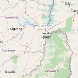
Map view of Esmeralda Provincial Park

Use this park location map to pinpoint Esmeralda Provincial Park in Argentina, understand its exact geographic position, and read its mapped placement within the surrounding landscape more clearly.

Pigeon | © OpenStreetMap contributors

Location context for Esmeralda Provincial Park

Misiones Province
Park atlas

Compare surrounding forested terrain and regional conservation units across Misiones

Other Parks and Protected Areas Near Esmeralda Provincial Park

Browse nearby protected landscapes and adjacent forest reserves to understand regional ecological connectivity beyond Esmeralda Provincial Park. Comparing these connected conservation areas reveals the wider geographic spread of the Alto Parana Atlantic forest ecoregion.
State or regional parkMisiones Province
About 74 km away#1 closest

North

Urugua-í Provincial Park: Exploring the Atlantic Forest Landscapes of Misiones Province

A regional atlas of protected watersheds and forest corridors

Spanning from the rolling lowlands of the Urugua-í River to the rugged slopes of the Sierra de la Victoria, this protected area represents one of the most significant forest blocks in the region. Examine the mapped drainage patterns, watershed connectivity, and forest mosaic that define this essential Argentine conservation landscape.

Area
840 km²
Established
1990
IUCN
II
Relief
Upland
National parkParaguay
About 109 km away#2 closest

Northwest

Ñacunday National Park National Park: Paraguay's Protected Landscape and Mapped Boundaries

Explore its unique geography and protected terrain.

Gain a precise understanding of Ñacunday National Park, a designated national park in Paraguay. This entry focuses on its role as a protected landscape, detailing its geographic attributes and mapped boundaries. It serves as a vital resource for users seeking specific information on the park's natural terrain and its contribution to Paraguay's conservation geography, facilitating structured discovery within the atlas.

Area
20 km²
Established
1993
Relief
Mixed relief
Climate
Subtropical
National parkMisiones Province
About 120 km away#3 closest

North

Iguazú National Park: Argentina's Misiones Province Protected Landscape Atlas

Explore mapped boundaries and regional geography.

Iguazú National Park serves as a key protected natural area situated within Misiones Province. This MoriAtlas entry details its mapped geographic boundaries, contributing essential context for understanding its landscape identity. Users can explore how this national park fits into the regional geography, providing a factual basis for detailed atlas-based study of protected lands and their unique terrain.

Area
677 km²
Established
1934
IUCN
II
Relief
Lowland
Natural monumentAlto Paraná Department
About 141 km away#4 closest

Northwest

Moisés Bertoni Scientific Monument: Protected Atlantic Forest in Alto Paraná, Paraguay

Natural monument and historic research landscape

Explore the geographic footprint of Moisés Bertoni Scientific Monument, an essential protected area in the Alto Paraná Department. This site safeguards mature Atlantic Forest ecosystems along the Paraná River while preserving the historic research station and cultural legacy of its founder. The monument remains a pivotal landmark for understanding the biodiversity and conservation landscape of eastern Paraguay.

Area
1.99 km²
Established
1955
Relief
Lowland
Climate
Subtropical
National parkItapúa Department
About 171 km away#5 closest

West

San Rafael National Park: National Park Protected Landscape & Geographic Overview

Discover the mapped boundaries and regional setting in Itapúa.

San Rafael National Park is a significant protected area designated as a national park in Paraguay's Itapúa Department. This page serves as an atlas-centric entry point, offering a detailed view of its geographic scope, mapped park boundaries, and its role as a conservation landscape. Users can explore the park's terrain and its place within the regional geography for a structured understanding of its protected status.

Area
693.04 km²
Established
1992
IUCN
II
Relief
Upland
Wildlife reserveAlto Paraná Department
About 173 km away#6 closest

North

Tatí Yupí Refuge: Wildlife Reserve Geography and Paraná River Landscape

A 2,245 hectare protected biological forest in Alto Paraná

Tatí Yupí Refuge offers a unique perspective on protected land management within the Itaipu hydroelectric complex. Explore the mapped boundaries, basaltic stream formations, and subtropical forest habitat that define this essential ecological refuge in Paraguay's Alto Paraná Department.

Area
22.45 km²
Established
1982
Relief
Lowland
Climate
Subtropical
A soft watercolor illustration depicting a serene landscape with rolling green hills, scattered trees, and a winding stream under a warm, light-colored sky.
Wildlife reserveCanindeyú Department
About 277 km away#7 closest

North

Refugio Carapá Wildlife Reserve: Mapping Biological Diversity in Canindeyú Department

A protected sub-tropical mosaic along the Paraná River basin

Refugio Carapá protects a dramatic stretch of mountain slopes and riverine valleys in the Department of Canindeyú. By managing a mosaic of tall forests, swamps, and open camp vegetation, the reserve maintains a crucial ecological link within the wider Itaipu reservoir landscape. The area functions as a research-focused environment dedicated to preserving native flora and threatened species in eastern Paraguay.

Area
32.5 km²
Established
1984
Relief
Mountain
Climate
Subtropical
A soft watercolor illustration of a landscape with green grassy fields in the foreground, calm water in the midground, and gentle rolling hills in the background under a pale, pinkish sky.
Nature reserveCanindeyú Department
About 332 km away#8 closest

Northwest

Mbaracayú Forest Nature Reserve: A Detailed Geographic Atlas of Paraguay's Protected Forest

Mapped terrain, forest corridors, and landscape features

Spanning over 64,000 hectares in the Canindeyú Department, Mbaracayú Forest Nature Reserve preserves the core of the Alto Paraná Atlantic forest. The area features a complex mosaic of subtropical forest, riparian corridors, and the undulating slopes of the Cordillera de Mbaracayú range. This map-focused profile details the reserve's unique topography, stream networks, and its vital role as a continuous wilderness block in eastern Paraguay.

Area
644.05 km²
Established
1991
IUCN
II
Relief
Upland

Common questions about visiting, size, designation, and location context for Esmeralda Provincial Park

Esmeralda Provincial Park FAQs for park facts, access, geography, and protected area context

Find quick answers about Esmeralda Provincial Park, including protected-area facts, park geography, trail and visitor context, and how the park fits into its surrounding country and regional landscape.
MoriAtlas Explorer

Continue Your Protected Areas Search Across the Global Atlas

Deepen your exploration by continuing the structured search for national parks and protected areas worldwide. Utilize the comprehensive filtering capabilities to compare different conservation landscapes and refine your understanding of global park geography. Discover more about the distribution and characteristics of protected natural areas.

Global natural geography