Mori Atlas logo
Natural monumentMoisés Bertoni Scientific Monument

Mapping the geographic boundaries and ecological heritage of this eastern Paraguay monument

Moisés Bertoni Scientific Monument: A Protected Atlantic Forest and Historic Research Landmark

(Monumento Científico Moisés Bertoni)

Moisés Bertoni Scientific Monument preserves a rare fragment of Atlantic Forest along the Paraná River in the Alto Paraná Department. This protected natural monument serves as both a critical conservation area and a historic site, marking the former laboratory and research station of naturalist Moisés Santiago Bertoni. The landscape features mature forest cover, riverfront terrain, and diverse riparian corridors within a significant ecological corridor.

Atlantic Forestriparian landscapeParaná Riverprotected foresthistoric sitenaturalist heritage

Moisés Bertoni Scientific Monument

Natural monument

Park overview

Structured park overview, official facts, and landscape profile for Moisés Bertoni Scientific Monument

Moisés Bertoni Scientific Monument park facts, protected area profile, and essential visitor context

Review the core facts for Moisés Bertoni Scientific Monument, including designation, size, terrain, visitor scale, habitats, and operating context in one park-focused overview.

About Moisés Bertoni Scientific Monument

The Moisés Bertoni Scientific Monument occupies a 199-hectare protected landscape on the right bank of the Paraná River, in the densely forested Upper Paraná region of eastern Paraguay. Its setting places it within ecoregion internationally regarded as the Alto Paraná Atlantic Forest, one of the most threatened forest biomes in South America. The reserve is bounded on the east by the Paraná River, on the north by the Monday River, on the south by the Itá Coty stream, and on the west by the road linking Presidente Franco to Los Cedrales, giving the protected area a clearly defined natural and administrative perimeter.

At the heart of the monument stands the preserved home of Moisés Santiago Bertoni, a Swiss-born naturalist who emigrated to Paraguay in 1894 with his family in pursuit of an idealist, agrarian community experiment. For more than three decades Bertoni worked at this riverside property, using the house simultaneously as a residence, laboratory, library, and writing office. His research covered botany, zoology, meteorology, and anthropology, and he collaborated closely with local Guaraní people who shared knowledge of medicinal plants. Bertoni's weather predictions, made from this site, were reportedly consulted by farmers in Paraguay, Brazil, and Argentina for decades after his death.

The site is significant not only as ecological habitat but also as a layered cultural landscape. Bertoni family burials originally took place near the house, and members of three indigenous Mbya villages continue to live within the boundaries of the reserve. The museum component holds Bertoni's manuscripts, books, letters, and personal objects, while the surrounding forest provides habitat for regionally threatened tree species including Euterpe edulis palm, Araucaria angustifolia (locally known as kuri'u), and tree ferns, as well as fauna such as the helmeted woodpecker.

In recent years the monument has also become a focal point for conservation enforcement in the Upper Paraná region. In 2024 Paraguayan authorities arrested 26 individuals suspected of illegal deforestation following monitoring activities within the reserve, underscoring both the ongoing pressure on the surrounding Atlantic Forest and the protected status of the monument as a stronghold for native vegetation in an increasingly fragmented landscape.

Quick facts and research context for Moisés Bertoni Scientific Monument

The Moisés Bertoni Scientific Monument was legally established as a protected area on 13 April 1955, making it one of Paraguay's older formally protected natural reserves. It is located in Presidente Franco District, Alto Paraná Department, roughly 26 kilometres from the city of Presidente Franco, and bordered by the Paraná River to the east and the Monday River to the north.

The reserve combines a forested protected landscape with a museum complex centred on the former home and laboratory of Moisés Santiago Bertoni, the Swiss naturalist who worked in Paraguay from 1894 until his death in 1929. The site is also home to indigenous Mbya villages and has been the focus of recent enforcement against illegal deforestation in the surrounding Atlantic Forest.

Protection and recognition

Documented terrestrial protection scope and international recognition records

Moisés Bertoni Scientific Monument Protection Status and Recognition Data

Moisés Bertoni Scientific Monument maintains a documented terrestrial protection scope without imported international recognition sources. Structured preservation records outline the official administrative status and governing framework associated with the protected landscape.

Protection details

Protection scope
Terrestrial
Transboundary protection
No
Park context

Deeper park guide and search-rich context for Moisés Bertoni Scientific Monument

Moisés Bertoni Scientific Monument history, landscape, wildlife, and travel context

Explore Moisés Bertoni Scientific Monument through its history, landscape character, ecosystems, wildlife, conservation priorities, cultural context, and seasonal travel timing in a structured park guide built for atlas discovery and search intent.

Why Moisés Bertoni Scientific Monument stands out

The monument is especially known for preserving the house, laboratory, and library of Moisés Santiago Bertoni, one of the most prolific naturalists to have worked in Paraguay. Bertoni's research, much of it produced under the motto Ex silvis ('from the jungle'), covered tropical botany, ethnobotany, meteorology, and the study of Guaraní culture, and shaped early scientific understanding of the Upper Paraná Atlantic Forest. Equally distinctive is the reserve itself: a protected fragment of Atlantic Forest along the Paraná River that harbours threatened species such as Araucaria angustifolia and the helmeted woodpecker. The combination of an ecologically significant forest reserve, a historic scientific site, and an active indigenous community makes the monument a unique cultural-natural landmark within Paraguay's protected-area system.
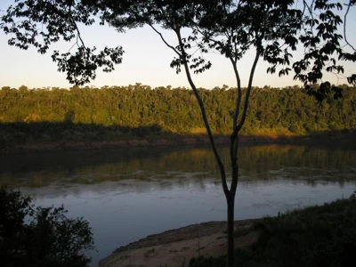
A view of the Parana River framed by tree branches in the foreground, with dense forest on the opposite bank under golden light.
The Parana River as seen from the historic residence of naturalist Moisés Bertoni.

Moisés Bertoni Scientific Monument history and protected-area timeline

The history of the Moisés Bertoni Scientific Monument begins with the arrival of Moisés Santiago Bertoni and his family in Paraguay in 1894. Bertoni, a Swiss naturalist and idealist, established his home and research station on a forested tract along the Paraná River, intending to pursue a self-sufficient rural community rooted in scientific and ethical principles. From this site he carried out decades of research in botany, meteorology, zoology, and anthropology, much of it in collaboration with members of the local Guaraní community.

Bertoni remained at the property until his death in 1929, and members of the Bertoni family were buried in a small cemetery near the house. Burials at that cemetery continued until they were later prohibited, leaving the cemetery as a quiet historical feature within the reserve.

Recognising the scientific, cultural, and ecological value of the property, the Paraguayan state formally established the Moisés Bertoni Scientific Monument as a protected natural area on 13 April 1955. The designation preserved both the former residence and laboratory and the surrounding forest, laying the foundation for the site to function simultaneously as a museum, a heritage monument, and a conservation area. Today the monument remains one of Paraguay's older formally protected sites and has increasingly become a symbolic focus for efforts to safeguard the Alto Paraná Atlantic Forest.

Moisés Bertoni Scientific Monument landscape and geographic character

The monument occupies a forested tract of land along the eastern edge of Paraguay, where the Paraná River forms a natural international boundary with Brazil. Its topography consists of undulating terrain typical of the Alto Paraná interior, with stream valleys, riparian corridors, and mature forest cover extending down to the riverbank. The Monday River runs along the northern edge of the reserve, just before its confluence with the Paraná, giving the site an unusually rich network of waterways.

The southern boundary is defined by the Itá Coty stream, while the western edge follows the road between Presidente Franco and Los Cedrales. From the house that anchors the protected area, visitors look out over the broad expanse of the Paraná River, with views framed by forest canopy and the distant Brazilian shore. The combination of mature forest, river fronts, and clear natural boundaries gives the reserve a strongly defined landscape character, distinct from the more fragmented agricultural matrix that surrounds it.
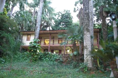
A two-story wooden house with a balcony surrounded by dense forest and tall trees, seen in the Moisés Bertoni Scientific Monument.
The historic home of naturalist Moisés Bertoni, preserved within the Moisés Bertoni Scientific Monument.

Moisés Bertoni Scientific Monument ecosystems, habitats, and plant life

Ecologically, the monument protects a remnant of the Alto Paraná Atlantic Forest, an ecoregion once widespread across southeastern Paraguay, southern Brazil, and northeastern Argentina but now greatly reduced by agricultural conversion. Within the reserve, the vegetation retains elements characteristic of the original forest, including emergent trees, dense understory, and palm-dominated patches along river edges. Tree ferns and native palms such as Euterpe edulis are recorded as part of the canopy and subcanopy, while the regionally iconic Araucaria angustifolia, locally known as kuri'u, is among the species documented within the property.

The forest at the monument is not only diverse in native composition but also carries a complex anthropogenic history. A reported share of the plant species present was introduced during Bertoni's lifetime, when exotic trees and cultivated plants were brought onto the property as part of his botanical experiments. These introduced species are concentrated within the reserve, contrasting with the native vegetation that persists in the surrounding Paraná region.

The proximity of the Paraná River also shapes the ecological context of the reserve, supporting riparian habitats along the riverbank and providing ecological connectivity with adjoining protected and forested landscapes to the north and south.

Moisés Bertoni Scientific Monument wildlife and species highlights

The protected forest at the monument supports a community of birds, mammals, and other species associated with the remnant Atlantic Forest of the Alto Paraná region. Among the most notable records is the helmeted woodpecker, Dryocopus galeatus, a regionally threatened species whose presence underscores the conservation significance of the reserve's mature forest habitat.

The combination of dense canopy, tree fern stands, and palm-rich understory typical of Upper Paraná Atlantic Forest provides habitat for forest-dependent bird species, while the riverbank and streams bordering the reserve create conditions for riparian and semi-aquatic wildlife. Although detailed fauna inventories are limited, the broader ecological context of the site, situated between the Paraná and Monday rivers and adjacent to extensive forested corridors, makes it an important refuge for native wildlife in a region where habitat loss has been severe.

Moisés Bertoni Scientific Monument conservation status and protection priorities

Established by law in 1955, the Moisés Bertoni Scientific Monument is among Paraguay's older formally protected natural areas and serves as a small but ecologically important stronghold for the Alto Paraná Atlantic Forest. Its protected status covers both the historic Bertoni homestead and the surrounding 199 hectares of forest, an unusually direct pairing of cultural heritage protection and habitat conservation.

The reserve's value from a conservation standpoint is heightened by the condition of the surrounding landscape. Much of the Atlantic Forest in eastern Paraguay has been converted to agriculture, leaving isolated forest fragments such as this one as critical refuges for native species. The presence of threatened trees like Araucaria angustifolia and fauna such as the helmeted woodpecker gives the monument regional conservation significance beyond its modest size.

In 2024 the monument became a notable case in regional conservation enforcement when Paraguayan authorities arrested 26 individuals suspected of illegal deforestation following monitoring at the reserve, illustrating both the pressures facing the surrounding forest and the active role of the protected area in safeguarding what remains of the native landscape. By linking habitat protection, indigenous land presence, and scientific heritage, the monument represents an integrated model of conservation that combines ecological, cultural, and historical dimensions.

Moisés Bertoni Scientific Monument cultural meaning and human context

The monument carries a layered cultural significance rooted in both the legacy of Moisés Santiago Bertoni and the continuing presence of indigenous communities within the reserve. Bertoni's arrival in 1894, along with his family and a circle of European idealists, was part of a broader late-19th-century movement that sought to combine scientific research with rural communal living. Much of his work at the site was carried out in collaboration with Guaraní people, from whom he learnt about the medicinal uses of local plants and incorporated this knowledge into his botanical and anthropological studies.

The cultural dimension of the site is also ongoing rather than purely historical. Three villages of the Mbya indigenous community are located within the boundaries of the reserve, and Mbya people continue to inhabit the property alongside park rangers. Visitors to the site often encounter Mbya cultural expressions such as traditional dance at dusk and the sale of handicrafts, providing a living cultural layer to the visits that complement the museum content.

The Bertoni family cemetery, located a short distance from the house, anchors the historic European dimension of the site, while the indigenous villages give the monument a continuous human presence that predates and outlasts Bertoni's research era. Together these elements make the monument a place where scientific, indigenous, and migratory European histories meet within a single protected landscape.

Top sights and standout views in Moisés Bertoni Scientific Monument

The monument combines a museum dedicated to one of Paraguay's most important naturalists with a protected fragment of Atlantic Forest along the Paraná River, a pairing that is rare within Paraguay's system of protected areas. Its principal highlights include the preserved house and laboratory of Moisés Bertoni, the family cemetery, the surrounding forest reserve with threatened species such as Araucaria angustifolia and the helmeted woodpecker, and the indigenous Mbya communities still living within the property.

Its scenic position on the Paraná River, framed by forest and bordering the Monday River, gives the site a distinctive riverside character that visitors experience through boat-based excursions from Paraguay, Brazil, and Argentina. The monument's combined identity as a scientific heritage site, a working indigenous landscape, and a conservation refuge in one of South America's most threatened forest ecoregions makes it a uniquely layered destination within eastern Paraguay.

Best time to visit Moisés Bertoni Scientific Monument

The Alto Paraná region records some of the highest rainfall in Paraguay, and conditions at the monument vary noticeably between dry and wet periods. Rainfall patterns influence both river levels on the Paraná, which shape boat-based access to Puerto Bertoni, and forest conditions within the reserve, with wetter periods producing lush vegetation and active wildlife and drier periods offering clearer views and easier walking.

Temperatures throughout the year are generally moderate to warm, with an annual average around 21°C, although seasonal extremes can range from near freezing in cooler periods to above 35°C in the warmest months. Because of this, many visitors find the cooler dry season particularly comfortable for combining the riverside approach with walking through the forest and the historic site, while the wet season rewards those interested in lush vegetation and full river views.

Monthly climate preview

Long-term temperature and precipitation averages for representative coordinates

Moisés Bertoni Scientific Monument Climate Normals and Weather by Month

Moisés Bertoni Scientific Monument records measured monthly temperature and precipitation normals derived from long-term NASA coordinate datasets. Examining the complete twelve-month climatology profile reveals specific annual shifts across average minimums, maximums, and daily rainfall rates.
Annual mean23 °C
17 °C27 °C
Jan27°
Feb27°
Mar26°
Apr23°
May19°
Jun17°
Jul17°
Aug19°
Sep21°
Oct24°
Nov25°
Dec27°
Warmest month
January

27.4 °C

Coolest month
July

16.6 °C

Wettest month
October

7 mm/day

Driest month
August

2.5 mm/day

Park location guide

Geography guide, regional context, and park location map for Moisés Bertoni Scientific Monument

Moisés Bertoni Scientific Monument park geography, regions, and map view in Paraguay

Understand where Moisés Bertoni Scientific Monument sits in Paraguay through a broader geographic reading of the surrounding landscape, nearby location context, and its mapped position within the national park landscape.

How Moisés Bertoni Scientific Monument fits into Paraguay

Paraguay is a landlocked presidential republic in central South America with a population of approximately 6.4 million. Originally inhabited by the Guaraní people, it was colonized by Spain in the 16th century and gained independence in 1811. The country is notable for its strong Guarani cultural influence, economic growth driven by soybean and beef exports, and significant hydroelectric power generation. Asunción is both the capital and largest city.

Wider geography shaping Moisés Bertoni Scientific Monument in Paraguay

Paraguay is located in the central region of South America, completely landlocked but with Atlantic Ocean access via the Paraná-Paraguay Waterway. It borders Bolivia to the northwest and north, Brazil to the northeast and east, and Argentina to the southeast, south, and west. The terrain consists mostly of rolling plains and lowlands, with the Paraguay River dividing the country into eastern and western regions.

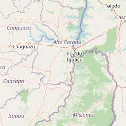
Map view of Moisés Bertoni Scientific Monument

Use this park location map to pinpoint Moisés Bertoni Scientific Monument in Paraguay, understand its exact geographic position, and read its mapped placement within the surrounding landscape more clearly.

Pigeon | © OpenStreetMap contributors

Location context for Moisés Bertoni Scientific Monument

Alto Paraná Department

Visual exploration of Atlantic Forest terrain, riverbanks, and protected habitats

Moisés Bertoni Scientific Monument Photos and Landscape Scenery

Photographic collections reveal the dense canopy, riverfront boundaries, and historic architecture defining Moisés Bertoni Scientific Monument. Visual records help researchers examine the unique protected-area character and remaining forest habitats across eastern Paraguay.

A view of the Parana River framed by tree branches in the foreground, with dense forest on the opposite bank under golden light.

Interior view of a laboratory with wooden workbenches in the foreground and white shelving units lining the back walls, filled with glass jars containing preserved natural history specimens.

A two-story wooden house with a balcony surrounded by dense forest and tall trees, seen in the Moisés Bertoni Scientific Monument.

Park atlas

Compare adjacent forest reserves and protected landscapes across the Upper Paraná region

Parks Near Moisés Bertoni Scientific Monument and Regional Protected Areas

Explore other protected areas near Moisés Bertoni Scientific Monument to examine related Atlantic Forest habitats and regional conservation zones. Comparing these nearby natural reserves provides a broader geographic understanding of eastern Paraguay and its interconnected river ecosystems.
National parkMisiones Province
About 12 km away#1 closest

East

Iguazú National Park: Argentina's Misiones Province Protected Landscape Atlas

Explore mapped boundaries and regional geography.

Iguazú National Park serves as a key protected natural area situated within Misiones Province. This MoriAtlas entry details its mapped geographic boundaries, contributing essential context for understanding its landscape identity. Users can explore how this national park fits into the regional geography, providing a factual basis for detailed atlas-based study of protected lands and their unique terrain.

Area
677 km²
Established
1934
IUCN
II
Relief
Lowland
Wildlife reserveAlto Paraná Department
About 33 km away#2 closest

North

Tatí Yupí Refuge: Wildlife Reserve Geography and Paraná River Landscape

A 2,245 hectare protected biological forest in Alto Paraná

Tatí Yupí Refuge offers a unique perspective on protected land management within the Itaipu hydroelectric complex. Explore the mapped boundaries, basaltic stream formations, and subtropical forest habitat that define this essential ecological refuge in Paraguay's Alto Paraná Department.

Area
22.45 km²
Established
1982
Relief
Lowland
Climate
Subtropical
State or regional parkMisiones Province
About 40 km away#3 closest

Southeast

Urugua-í Provincial Park: Exploring the Atlantic Forest Landscapes of Misiones Province

A regional atlas of protected watersheds and forest corridors

Spanning from the rolling lowlands of the Urugua-í River to the rugged slopes of the Sierra de la Victoria, this protected area represents one of the most significant forest blocks in the region. Examine the mapped drainage patterns, watershed connectivity, and forest mosaic that define this essential Argentine conservation landscape.

Area
840 km²
Established
1990
IUCN
II
Relief
Upland
National parkParaguay
About 45 km away#4 closest

South

Ñacunday National Park National Park: Paraguay's Protected Landscape and Mapped Boundaries

Explore its unique geography and protected terrain.

Gain a precise understanding of Ñacunday National Park, a designated national park in Paraguay. This entry focuses on its role as a protected landscape, detailing its geographic attributes and mapped boundaries. It serves as a vital resource for users seeking specific information on the park's natural terrain and its contribution to Paraguay's conservation geography, facilitating structured discovery within the atlas.

Area
20 km²
Established
1993
Relief
Mixed relief
Climate
Subtropical
State or regional parkMisiones Province
About 141 km away#5 closest

Southeast

Esmeralda Provincial Park: Protected Forest Landscapes and Geography in Misiones

A critical node in the Alto Parana Atlantic forest ecosystem

Esmeralda Provincial Park represents a significant protected area within the Misiones Province, acting as a core unit for the Yaboti Biosphere Reserve. The terrain is characterized by dense subtropical forest and rugged topography shaped by the Yaboti Guazu drainage network. This area serves as a primary site for forest biodiversity research, highlighting the ecological value of continuous, undisturbed forest tracts within the broader Argentine Mesopotamia region.

Area
316.19 km²
Established
1997
IUCN
II
Relief
Upland
National parkItapúa Department
About 142 km away#6 closest

Southwest

San Rafael National Park: National Park Protected Landscape & Geographic Overview

Discover the mapped boundaries and regional setting in Itapúa.

San Rafael National Park is a significant protected area designated as a national park in Paraguay's Itapúa Department. This page serves as an atlas-centric entry point, offering a detailed view of its geographic scope, mapped park boundaries, and its role as a conservation landscape. Users can explore the park's terrain and its place within the regional geography for a structured understanding of its protected status.

Area
693.04 km²
Established
1992
IUCN
II
Relief
Upland
A soft watercolor illustration depicting a serene landscape with rolling green hills, scattered trees, and a winding stream under a warm, light-colored sky.
Wildlife reserveCanindeyú Department
About 146 km away#7 closest

North

Refugio Carapá Wildlife Reserve: Mapping Biological Diversity in Canindeyú Department

A protected sub-tropical mosaic along the Paraná River basin

Refugio Carapá protects a dramatic stretch of mountain slopes and riverine valleys in the Department of Canindeyú. By managing a mosaic of tall forests, swamps, and open camp vegetation, the reserve maintains a crucial ecological link within the wider Itaipu reservoir landscape. The area functions as a research-focused environment dedicated to preserving native flora and threatened species in eastern Paraguay.

Area
32.5 km²
Established
1984
Relief
Mountain
Climate
Subtropical
A soft watercolor illustration of a landscape with green grassy fields in the foreground, calm water in the midground, and gentle rolling hills in the background under a pale, pinkish sky.
Nature reserveCanindeyú Department
About 191 km away#8 closest

Northwest

Mbaracayú Forest Nature Reserve: A Detailed Geographic Atlas of Paraguay's Protected Forest

Mapped terrain, forest corridors, and landscape features

Spanning over 64,000 hectares in the Canindeyú Department, Mbaracayú Forest Nature Reserve preserves the core of the Alto Paraná Atlantic forest. The area features a complex mosaic of subtropical forest, riparian corridors, and the undulating slopes of the Cordillera de Mbaracayú range. This map-focused profile details the reserve's unique topography, stream networks, and its vital role as a continuous wilderness block in eastern Paraguay.

Area
644.05 km²
Established
1991
IUCN
II
Relief
Upland

Common questions about visiting, size, designation, and location context for Moisés Bertoni Scientific Monument

Moisés Bertoni Scientific Monument FAQs for park facts, access, geography, and protected area context

Find quick answers about Moisés Bertoni Scientific Monument, including protected-area facts, park geography, trail and visitor context, and how the park fits into its surrounding country and regional landscape.
MoriAtlas Explorer

Continue Your Protected Areas Search Across the Global Atlas

Deepen your exploration by continuing the structured search for national parks and protected areas worldwide. Utilize the comprehensive filtering capabilities to compare different conservation landscapes and refine your understanding of global park geography. Discover more about the distribution and characteristics of protected natural areas.

Global natural geography