Mori Atlas logo
Wildlife reserveRefugio Carapá

A vital biological sanctuary in Canindeyú Department defined by steep mountain terrain and riparian corridors

Refugio Carapá Wildlife Reserve: Protected Landscapes and Paraná River Basin Geography

Refugio Carapá serves as a critical biological research station and protected habitat within the Canindeyú Department of eastern Paraguay. Encompassing 3,250 hectares, the reserve features a diverse terrain of tall forests, swamps, and open camp vegetation along the right bank of the Paraná River. This site plays a key role in the regional Itaipu conservation network, preserving a unique sample of sub-tropical humid habitat that remains largely undisturbed.

biological reservesub-tropical forestParaná River basinItaipu conservation networkCanindeyúmountain slopes

Refugio Carapá

Wildlife reserve

Park overview

Structured park overview, official facts, and landscape profile for Refugio Carapá

Refugio Carapá park facts, protected area profile, and essential visitor context

Review the core facts for Refugio Carapá, including designation, size, terrain, visitor scale, habitats, and operating context in one park-focused overview.

About Refugio Carapá

Refugio Carapá occupies the rugged right-bank country of the Paraná River in Paraguay's Department of Canindeyú, an area of mountains and very steep slopes overlaid with latosol red clays. The reserve was created in 1984, two years after the Itaipu Dam flooded its namesake valley and formed one of the world's largest artificial lakes. Within the Itaipu conservation system, it functions simultaneously as a refuge for threatened native ecosystems and as a research base where the drainage basin of the Carapá River is monitored for ecological change.

The refuge's terrain is unusually varied for a relatively compact protected area. Steep ridges and valley walls descend toward the Paraná, where the river's natural flow has been reconfigured by the Itaipu reservoir. Soils of textured red clay support forests ranging from tall closed-canopy stands to lower growth on thinner soils, interspersed with swampy bottomlands, high and low open camp vegetation, and remnants of primitive forest close to the river. The result is a mosaic in which different habitats sit within short distances of one another, allowing researchers to compare plant communities and animal populations across contrasting micro-environments.

Beyond its scientific role, Refugio Carapá is also a node in a wider regional landscape shift. Where agriculture once dominated the local economy along the Paraná, tourism and recreation around the reservoir have grown in importance, with artificial beaches and watersports drawing visitors from neighboring municipalities. The reserve itself supports limited recreational use, including self-guided interpretive trails, scenic lookouts, and a panoramic viewpoint that surveys both the forested slopes and the vast expanse of water held back by Itaipu. This combination of research, conservation, and emerging ecotourism gives Refugio Carapá a distinctive identity within Paraguay's system of protected natural areas.

Quick facts and research context for Refugio Carapá

Refugio Carapá is located in the Department of Canindeyú, Paraguay, on the right bank of the Paraná River, approximately 260 kilometers north of Ciudad del Este. It was founded in 1984 as one of eight ecological reserves associated with the Itaipu Binational hydroelectric project and covers about 3,250 hectares. The climate is humid and warm, classified as sub-mesothermal humid tropical, with annual rainfall near 1,300 millimeters. The reserve belongs to a management framework that divides its territory into core, extensive-use, intensive-use, special-use, and buffer zones, with permanent facilities for researchers and technicians.

Protection and recognition

Documented terrestrial protection scope, designation history, and recognition sources

Refugio Carapá Protection Status and International Recognition Data

Refugio Carapá maintains a documented terrestrial protection scope without imported international recognition sources or assigned designation years in the registry. Conservation researchers consult these records to verify formal administrative status, management boundaries, and baseline geographic parameters.

Protection details

Protection scope
Terrestrial
Transboundary protection
No
Park context

Deeper park guide and search-rich context for Refugio Carapá

Refugio Carapá history, landscape, wildlife, and travel context

Explore Refugio Carapá through its history, landscape character, ecosystems, wildlife, conservation priorities, cultural context, and seasonal travel timing in a structured park guide built for atlas discovery and search intent.

Why Refugio Carapá stands out

Refugio Carapá is known for protecting a steep, forested slice of the Paraná River basin adjacent to the Itaipu reservoir, while serving as a living laboratory for the Itaipu conservation program. Its drainage basin supports tall forest, low forest, swamps, and open camp vegetation dominated by trees such as Tabebuia, Peltophorum dubium, and Cedrela fissilis, and provides habitat for endangered species that have largely disappeared from surrounding landscapes. The reserve's zoned management approach, with a strictly protected core area and a panoramic viewpoint overlooking the lake, gives it both scientific and scenic distinction within Paraguay's protected-area network.
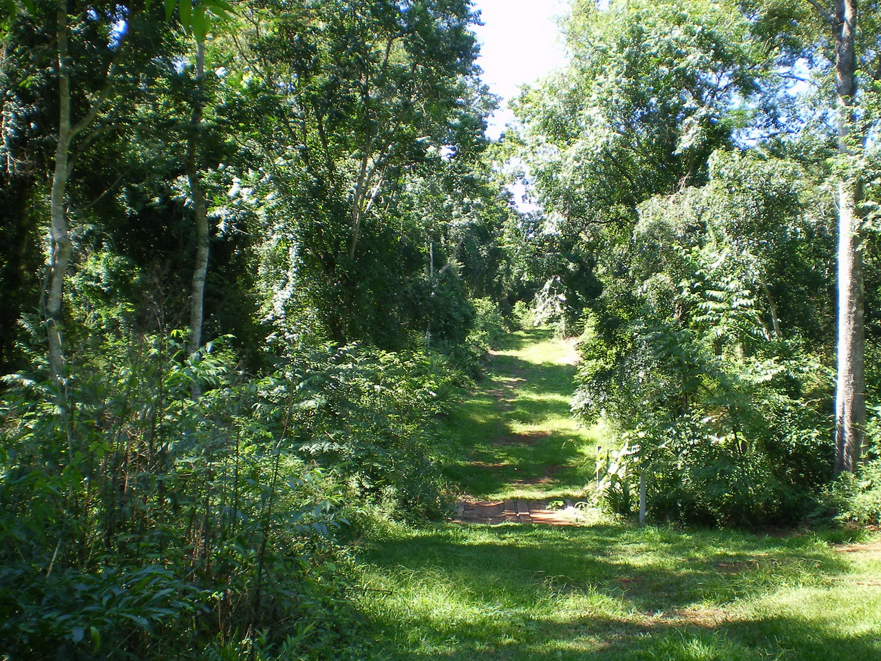
A dirt hiking trail leads into a dense, green forest with dappled sunlight filtering through the canopy.
A shaded hiking trail path winding through the lush forest of Refugio Carapa.

Refugio Carapá history and protected-area timeline

Refugio Carapá was founded in 1984 as part of the Itaipu Binational hydroelectric project's ecological reserve network, two years after the Itaipu Dam was completed and the artificial lake that bears its name began to fill the Paraná River valley. The reserve was conceived at a moment when the flooding of vast tracts of forest and farmland created an urgent need to set aside surviving natural areas for study and protection.

From its establishment, the refuge was oriented toward long-term scientific monitoring rather than mass tourism. Itaipu built on-site infrastructure so that researchers and technicians could live there full time, focusing on the environmental condition of the Carapá River drainage basin, on mammals, birds, and fish, on plants, on water chemistry, and on soils and climate. Over the decades, the reserve has also come to serve as an ecotourism destination, evolving alongside the broader transformation of the lakeshore economy from agriculture toward recreation and visitor services.

Refugio Carapá landscape and geographic character

The landscape of Refugio Carapá is shaped by a dramatic meeting of mountain, river valley, and reservoir. The reserve falls within a section of the Paraná highlands where ridges and very steep slopes frame the right bank of the river, with latosol red clays giving the terrain its characteristic coloration and drainage patterns. Below the steeper ramparts, the Carapá River basin is fed by multiple tributaries that rise in different parts of the Department of Canindeyú, carving the slopes into alternating bands of forest, scrub, and open ground.

To the south, the Itaipu reservoir dominates the horizon. The artificial lake created by the dam in 1982 reaches deep into the original river system, and its bays and inlets extend more than a thousand kilometers when measured along their winding edges. From the reserve's panoramic viewpoint, the wooded slopes tumble down toward this vast body of water, providing one of the most striking vantage points on the entire reservoir. Vegetation cover on the slopes is dense and heterogeneous, ranging from tall riparian forest near the water to lower forests and camp formations on the drier ridges.

Refugio Carapá ecosystems, habitats, and plant life

Refugio Carapá protects a rich mosaic of sub-tropical humid habitats compressed into a relatively small area. The vegetation ranges from tall, closed-canopy forest to lower forest formations, swampy bottomlands, high and open camp vegetation, low camp vegetation, stands of primitive forest, and narrow corridors of riverine forest close to the Paraná and its tributaries. This layering produces strong habitat diversity within short distances, allowing different plant and animal communities to coexist in close proximity.

The botanical character of the refuge is defined in part by the dominance of key tree species associated with Atlantic Forest and Paraná basin ecosystems, including Tabebuia, Peltophorum dubium, and Cedrela fissilis. These species anchor the canopy and provide structural complexity for the wider forest community. The presence of swamps and seasonally wet areas adds further ecological variety, supporting plants and animals adapted to waterlogged soils and creating transition zones between terrestrial and aquatic habitats. The Carapá River basin functions as the ecological backbone of the reserve, integrating the terrestrial and aquatic systems that Itaipu's conservation program was designed to study and protect.

Refugio Carapá wildlife and species highlights

Wildlife in Refugio Carapá reflects the broader ecological importance of the Itaipu reserve system. Many of the animal species recorded in the refuge fall within categories of conservation concern, which has helped drive the reserve's role as a refuge for fauna that has declined elsewhere in the region. Less threatened species also persist here, including the neotropical otter, which uses the Carapá River and its tributaries, and the collared peccary, which ranges through the forested slopes.

Among carnivores, members of the genus Felis have suffered territorial displacement as human pressure has intensified around the lake, making the reserve an increasingly important refuge for these predators. Birds, mammals, and fish are all subjects of ongoing study within Itaipu's research framework, and more than half of the species recorded across the entire Itaipu dam area are associated in some way with the Carapá River basin. This concentration of biodiversity makes the reserve a disproportionately significant site for conservation in eastern Paraguay.

Refugio Carapá conservation status and protection priorities

Refugio Carapá sits at the core of Itaipu Binational's ecological reserve network, which designated eight protected sites to compensate, at least in part, for the ecological disruption caused by the construction of one of the world's largest hydroelectric dams. The refuge's conservation focus is on preserving representative samples of the Paraná basin's sub-tropical humid ecosystems and on monitoring how these ecosystems respond to the presence of the artificial lake and to surrounding human activity.

The reserve is structured around a typical zoned management framework, with a strictly protected core zone containing three distinct nuclei of minimally disturbed natural habitat. Around it lie buffer and recovery areas, where degraded land adjacent to surrounding communities is being managed to reduce pressure on the core. Extensive-use and intensive-use zones permit controlled education, recreation, and low-impact tourism, while small special-use zones accommodate administrative buildings, staff housing, and the aviation runway. This layered approach reflects Itaipu's broader strategy of combining ecological research, habitat recovery, environmental education, and sustainable tourism within a single protected landscape.

Refugio Carapá cultural meaning and human context

The cultural context of Refugio Carapá is bound up with the social transformation that followed the Itaipu Dam. Before the reservoir filled, the surrounding region supported a primarily agricultural economy along the Paraná River valley. After the lake was created in 1982, that economic base began shifting toward tourism, recreation, and conservation-linked services, and seventy-seven neighboring municipalities now engage with the reservoir's economic potential, including artificial beaches along the lakeshore.

Within this shifting landscape, the reserve functions as a meeting point between traditional rural land use and a newer conservation-oriented economy. Researchers, technicians, and visiting students share the site with a growing flow of regional tourists, and the refuge has become a point of identity for Canindeyú's environmental work. The panoramic viewpoint and interpretive trails reflect an effort to make the protected area both a scientific station and a place where the public can engage directly with the region's natural heritage.

Top sights and standout views in Refugio Carapá

Refugio Carapá combines steep forested slopes on the right bank of the Paraná River with a frontline role in Itaipu's conservation program. Its 3,250 hectares encompass tall forest, low forest, swamps, and open camp vegetation, supporting species such as Tabebuia, Peltophorum dubium, and Cedrela fissilis, alongside threatened wildlife that has retreated from surrounding landscapes. The reserve's strict core zone, panoramic viewpoint over the Itaipu reservoir, and permanent research station make it both a significant conservation site and a productive ecological observatory within eastern Paraguay.

Best time to visit Refugio Carapá

Refugio Carapá's humid sub-tropical climate keeps the landscape green and biologically active throughout the year, with annual rainfall near 1,300 millimeters. Visiting during the drier months tends to make the reserve's trails, viewpoints, and lakeshore panoramas more accessible, while the warmer and wetter periods bring out the full vigor of the forests, swamps, and river habitats. As a research-oriented reserve rather than a high-volume tourist destination, it rewards visits by travelers who appreciate a quieter, observation-focused experience of the Paraná basin.

Monthly climate preview

Long-term temperature ranges and monthly precipitation records from 1991 to 2020

Refugio Carapá Climate Normals and Measured Annual Weather Patterns

Historical monitoring data records annual temperature and precipitation cycles across twelve distinct monthly intervals at Refugio Carapá. Detailed multi-year climatology profiles reveal month-by-month averages for daily highs, lows, and rainfall distributions.
Annual mean23 °C
17 °C28 °C
Jan28°
Feb27°
Mar27°
Apr24°
May20°
Jun18°
Jul17°
Aug19°
Sep22°
Oct25°
Nov26°
Dec27°
Warmest month
January

27.7 °C

Coolest month
July

17.4 °C

Wettest month
October

6.2 mm/day

Driest month
July

2.4 mm/day

Park location guide

Geography guide, regional context, and park location map for Refugio Carapá

Refugio Carapá park geography, regions, and map view in Paraguay

Understand where Refugio Carapá sits in Paraguay through a broader geographic reading of the surrounding landscape, nearby location context, and its mapped position within the national park landscape.

How Refugio Carapá fits into Paraguay

Paraguay is a landlocked presidential republic in central South America with a population of approximately 6.4 million. Originally inhabited by the Guaraní people, it was colonized by Spain in the 16th century and gained independence in 1811. The country is notable for its strong Guarani cultural influence, economic growth driven by soybean and beef exports, and significant hydroelectric power generation. Asunción is both the capital and largest city.

Wider geography shaping Refugio Carapá in Paraguay

Paraguay is located in the central region of South America, completely landlocked but with Atlantic Ocean access via the Paraná-Paraguay Waterway. It borders Bolivia to the northwest and north, Brazil to the northeast and east, and Argentina to the southeast, south, and west. The terrain consists mostly of rolling plains and lowlands, with the Paraguay River dividing the country into eastern and western regions.

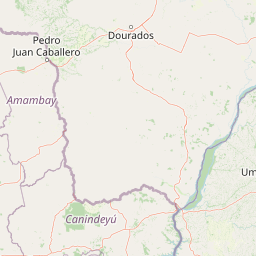
Map view of Refugio Carapá

Use this park location map to pinpoint Refugio Carapá in Paraguay, understand its exact geographic position, and read its mapped placement within the surrounding landscape more clearly.

Pigeon | © OpenStreetMap contributors

Location context for Refugio Carapá

Canindeyú Department

Explore photographic records of steep mountain terrain, subtropical forests, and reservoir viewpoints.

Refugio Carapá Photos and Landscape Scenery: Visualizing the Paraná River Basin

Photographic collections reveal the complex terrain, river valleys, and dense forest habitats protected within the biological reserve. Visual archives help researchers and naturalists examine the physical character of steep slopes meeting the hydroelectric reservoir.

A dirt hiking trail leads into a dense, green forest with dappled sunlight filtering through the canopy.

A rustic wooden entrance archway over a red dirt road, with a sign reading Bienvenidos al Refugio Biológico Carapá, surrounded by lush green trees.

Park atlas

Compare adjacent forest reserves and related habitats across eastern Paraguay

Parks Near Refugio Carapá and Protected Areas in the Surrounding Region

Browsing parks near Refugio Carapá reveals connected protected landscapes along the Paraná River basin and neighboring reservoir territories. Expanding the geographic comparison provides a clearer view of regional sub-tropical humid habitats and conservation networks.
A soft watercolor illustration of a landscape with green grassy fields in the foreground, calm water in the midground, and gentle rolling hills in the background under a pale, pinkish sky.
Nature reserveCanindeyú Department
About 109 km away#1 closest

West

Mbaracayú Forest Nature Reserve: A Detailed Geographic Atlas of Paraguay's Protected Forest

Mapped terrain, forest corridors, and landscape features

Spanning over 64,000 hectares in the Canindeyú Department, Mbaracayú Forest Nature Reserve preserves the core of the Alto Paraná Atlantic forest. The area features a complex mosaic of subtropical forest, riparian corridors, and the undulating slopes of the Cordillera de Mbaracayú range. This map-focused profile details the reserve's unique topography, stream networks, and its vital role as a continuous wilderness block in eastern Paraguay.

Area
644.05 km²
Established
1991
IUCN
II
Relief
Upland
Wildlife reserveAlto Paraná Department
About 113 km away#2 closest

South

Tatí Yupí Refuge: Wildlife Reserve Geography and Paraná River Landscape

A 2,245 hectare protected biological forest in Alto Paraná

Tatí Yupí Refuge offers a unique perspective on protected land management within the Itaipu hydroelectric complex. Explore the mapped boundaries, basaltic stream formations, and subtropical forest habitat that define this essential ecological refuge in Paraguay's Alto Paraná Department.

Area
22.45 km²
Established
1982
Relief
Lowland
Climate
Subtropical
National parkMisiones Province
About 132 km away#3 closest

South

Iguazú National Park: Argentina's Misiones Province Protected Landscape Atlas

Explore mapped boundaries and regional geography.

Iguazú National Park serves as a key protected natural area situated within Misiones Province. This MoriAtlas entry details its mapped geographic boundaries, contributing essential context for understanding its landscape identity. Users can explore how this national park fits into the regional geography, providing a factual basis for detailed atlas-based study of protected lands and their unique terrain.

Area
677 km²
Established
1934
IUCN
II
Relief
Lowland
Natural monumentAlto Paraná Department
About 146 km away#4 closest

South

Moisés Bertoni Scientific Monument: Protected Atlantic Forest in Alto Paraná, Paraguay

Natural monument and historic research landscape

Explore the geographic footprint of Moisés Bertoni Scientific Monument, an essential protected area in the Alto Paraná Department. This site safeguards mature Atlantic Forest ecosystems along the Paraná River while preserving the historic research station and cultural legacy of its founder. The monument remains a pivotal landmark for understanding the biodiversity and conservation landscape of eastern Paraguay.

Area
1.99 km²
Established
1955
Relief
Lowland
Climate
Subtropical
State or regional parkMisiones Province
About 151 km away#5 closest

South

Urugua-í Provincial Park: Exploring the Atlantic Forest Landscapes of Misiones Province

A regional atlas of protected watersheds and forest corridors

Spanning from the rolling lowlands of the Urugua-í River to the rugged slopes of the Sierra de la Victoria, this protected area represents one of the most significant forest blocks in the region. Examine the mapped drainage patterns, watershed connectivity, and forest mosaic that define this essential Argentine conservation landscape.

Area
840 km²
Established
1990
IUCN
II
Relief
Upland
National parkParaguay
About 190 km away#6 closest

South

Ñacunday National Park National Park: Paraguay's Protected Landscape and Mapped Boundaries

Explore its unique geography and protected terrain.

Gain a precise understanding of Ñacunday National Park, a designated national park in Paraguay. This entry focuses on its role as a protected landscape, detailing its geographic attributes and mapped boundaries. It serves as a vital resource for users seeking specific information on the park's natural terrain and its contribution to Paraguay's conservation geography, facilitating structured discovery within the atlas.

Area
20 km²
Established
1993
Relief
Mixed relief
Climate
Subtropical
National parkParaguay
About 262 km away#7 closest

Northwest

Cerro Corá National Park: Paraguay's Protected Landscape and Regional Geography

Discover the mapped boundaries and natural context of this national park.

Cerro Corá National Park serves as a critical element in Paraguay's protected natural areas. This page offers a deep dive into its identity as a national park, focusing on its geographic location, mapped boundaries, and its place within the broader landscape context of South America. Understand the specific atlas value of this protected land for detailed geographic exploration.

IUCN
II
National parkItapúa Department
About 267 km away#8 closest

Southwest

San Rafael National Park: National Park Protected Landscape & Geographic Overview

Discover the mapped boundaries and regional setting in Itapúa.

San Rafael National Park is a significant protected area designated as a national park in Paraguay's Itapúa Department. This page serves as an atlas-centric entry point, offering a detailed view of its geographic scope, mapped park boundaries, and its role as a conservation landscape. Users can explore the park's terrain and its place within the regional geography for a structured understanding of its protected status.

Area
693.04 km²
Established
1992
IUCN
II
Relief
Upland

Common questions about visiting, size, designation, and location context for Refugio Carapá

Refugio Carapá FAQs for park facts, access, geography, and protected area context

Find quick answers about Refugio Carapá, including protected-area facts, park geography, trail and visitor context, and how the park fits into its surrounding country and regional landscape.
MoriAtlas Explorer

Continue Your Protected Areas Search Across the Global Atlas

Deepen your exploration by continuing the structured search for national parks and protected areas worldwide. Utilize the comprehensive filtering capabilities to compare different conservation landscapes and refine your understanding of global park geography. Discover more about the distribution and characteristics of protected natural areas.

Global natural geography