

Mori Atlas logo
Wildlife reserveTatí Yupí Refuge

A riparian subtropical forest reserve bordering the expansive Itaipu hydroelectric reservoir

Tatí Yupí Refuge Wildlife Reserve and Protected Landscape in the Alto Paraná Department

Tatí Yupí Refuge protects 2,245 hectares of subtropical forest and stream valleys along the banks of the Paraná River in eastern Paraguay. This biological reserve functions as a critical green space, showcasing a unique mosaic of mature high forest, planted yerba mate, and basaltic watercourses that drain into the Itaipu reservoir. Our mapped data provides a detailed look at the terrain and boundaries of this vital ecological corridor near the Hernandarias urban area.

biological reservesubtropical forestParaná RiverItaipuecological reserveriparian habitat
A digital illustration depicting a path lined with palm trees leading toward a waterfall in a lush, green landscape under a soft sky.

Tatí Yupí Refuge

Wildlife reserve

Park overview

Structured park overview, official facts, and landscape profile for Tatí Yupí Refuge

Tatí Yupí Refuge park facts, protected area profile, and essential visitor context

Review the core facts for Tatí Yupí Refuge, including designation, size, terrain, visitor scale, habitats, and operating context in one park-focused overview.

About Tatí Yupí Refuge

Tatí Yupí sits within one of Paraguay's most economically and ecologically significant regions, where the Paraná River marks the country's border with Brazil and where Itaipu Binational has transformed the landscape through one of the world's largest hydroelectric developments. As one of eight ecological reserves earmarked along the Itaipu perimeter, Tatí Yupí represents a deliberate effort to maintain substantial forested habitat amid the infrastructure corridor that dominates Alto Paraná.

The refuge covers a relatively uniform terrain, broken mainly by gentle undulations and basaltic formations. Small streams, such as Tati Yupi and Pira Pytâ, descend toward the Paraná through cascades and small waterfalls, adding dramatic local scenery to what is otherwise a continuous forest mosaic. The reserve borders the artificial lake produced when Itaipu was completed in 1982, so its visual setting combines naturally forested slopes with a wide expanse of open water.

Tatí Yupí's ecological importance is amplified by its role as a buffer and habitat island within a heavily modified landscape. Mature high forest, regenerating areas, and commercial yerba mate plantations coexist inside its boundaries, and the reserve supports research, environmental education, and ongoing reforestation work. Because it is easily reached from Hernandarias and the surrounding cities, it also serves as a regular destination for walking, hiking, and guided interpretive outings, linking conservation with everyday recreation.

Quick facts and research context for Tatí Yupí Refuge

Tatí Yupí is a biological reserve of about 2,245 hectares located in Hernandarias district, Alto Paraná Department, Paraguay. It lies along the right bank of the Paraná River and borders the artificial lake created by the Itaipu hydroelectric dam, completed in 1982. The refuge was established by Itaipu as one of eight designated ecological reserves and has a subtropical climate with annual rainfall between 1,500 and 1,700 mm and mean temperatures of about 21 to 22 °C. It functions as a conservation site, outdoor education center, and accessible green area for the bordering tri-city urban region.

Protection and recognition

Examine terrestrial protection metrics and official recognition data for Tatí Yupí Refuge

Tatí Yupí Refuge Protection Status and Designated Conservation Scope

Conservation records document the terrestrial protection status and management scope established for Tatí Yupí Refuge. Systematic atlas tracking indexes international recognition frameworks and protected area data without presumption of specific legal outcomes.

Protection details

Protection scope
Terrestrial
Transboundary protection
No
Park context

Deeper park guide and search-rich context for Tatí Yupí Refuge

Tatí Yupí Refuge history, landscape, wildlife, and travel context

Explore Tatí Yupí Refuge through its history, landscape character, ecosystems, wildlife, conservation priorities, cultural context, and seasonal travel timing in a structured park guide built for atlas discovery and search intent.

Why Tatí Yupí Refuge stands out

Tatí Yupí is best known for being one of the ecological reserves established by the Itaipu hydroelectric project, and for its position right on the banks of the Paraná River next to the vast reservoir lake created by the dam. Its combination of tall subtropical forest, yerba mate plantations, and small basaltic streams with waterfalls gives it a highly scenic character unusual for lowland Paraguay. The reserve is also recognized for its proximity to a major urban corridor, including Hernandarias, Ciudad del Este, and Presidente Franco, which makes it a notable example of a large forest reserve functioning as a regional green space. Educational trails, environmental interpretation programs, and ongoing forest restoration work further reinforce its identity as a working biological reserve rather than a purely passive protected zone.
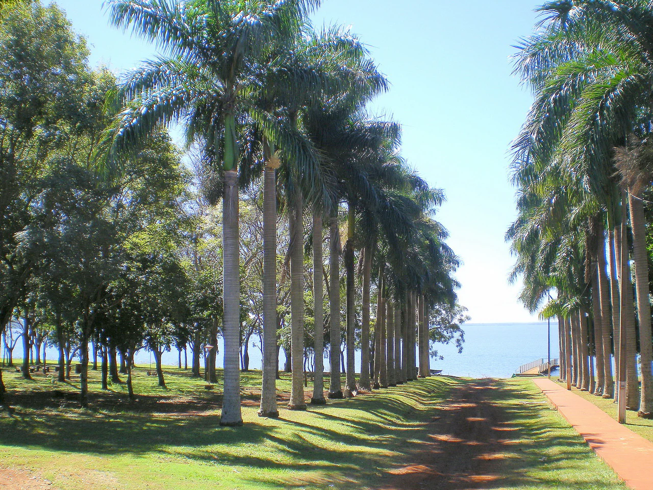
A dirt path lined by two rows of tall palm trees leading toward a large lake under a clear blue sky.
A picturesque row of palm trees lining a path towards the water at the Tatí Yupí Refuge.

Tatí Yupí Refuge history and protected-area timeline

Tatí Yupí came into being as part of the environmental mitigation strategy for the Itaipu hydroelectric dam, which began filling its reservoir in 1982. Itaipu Binational designated the refuge as one of eight ecological reserves along the Paraguayan side of the dam's influence area, framing the site as a long-term conservation counterweight to the transformation of the Paraná landscape.

Since that designation, the reserve has evolved into a working biological station rather than only a protected forest. It has hosted scientific research on indigenous flora and fauna, environmental education programs for schools and visitors, and ongoing restoration projects that include afforestation and enrichment planting in degraded forest patches. The combination of research, education, and active reforestation has shaped the refuge's identity as one of Itaipu's flagship conservation sites in Paraguay.

Tatí Yupí Refuge landscape and geographic character

The refuge occupies a stretch of the right bank of the Paraná River, where the topography is generally gentle but punctuated by undulations derived from underlying basaltic rocks. These low geological formations give rise to small streams such as Tati Yupi and Pira Pytâ, which form cascades and modest waterfalls as they move toward the river. The combination of rounded slopes, watercourses, and forest cover gives the reserve a layered visual profile despite its modest relief.

The most striking landscape feature is the long frontage onto the Itaipu reservoir. The artificial lake created when the dam was completed in 1982 meets the forested edge of the refuge, producing an unusual juxtaposition of dense subtropical forest with broad open water. Inland from the reservoir, the terrain continues as a mosaic of tall forest, lower canopy patches, yerba mate plantations, and narrow stream valleys that together create a sense of continuous, diverse forest habitat.

Tatí Yupí Refuge ecosystems, habitats, and plant life

Tatí Yupí preserves a representative slice of the forest ecosystems that once dominated the Paraná basin in this part of Paraguay. Its vegetation includes high forests that carry species such as cedro, lapacho, ybyrá pytá, and guatambú, some reaching heights above 30 meters. Beneath this upper stratum lies a dense secondary layer featuring myrtaceous species like ñangapiry, yva poroity, guava, kanelon, and ka'a vera, along with a wide assortment of continuous and shrubby trees averaging roughly three to seven meters in height.

The reserve also incorporates planted yerba mate stands (yerbales) alongside naturally regenerating forest, giving it a mixed landscape of native and cultivated vegetation. Epiphytes, tree ferns, palms, bromeliads, orchids, and piperaceae grow throughout the canopy, reflecting the high humidity and warmth of the local subtropical climate. The combination of mature forest, plantations, and restored patches makes the refuge a useful living laboratory for studying forest structure, succession, and habitat recovery in the Paraná watershed.

Tatí Yupí Refuge wildlife and species highlights

Although the source material emphasizes plant life more strongly than animal life, Tatí Yupí supports a forest fauna typical of the lower Paraná basin in Alto Paraná. The continuous canopy, layered vegetation, and streamside habitats provide shelter for a range of bird, mammal, reptile, and insect species adapted to subtropical forest conditions in eastern Paraguay.

The reserve's ecological diversity, including high forest, yerba mate plantations, wet low areas, and waterside environments along the Paraná, encourages a varied wildlife community. Itaipu's broader conservation program uses the refuge and its companion reserves as sites for faunal research, monitoring the relationships between native flora, fauna, and the local environment. This makes the park an important regional reference point for wildlife associated with interior Atlantic-style forests rather than open cerrado or Pantanal-type ecosystems.

Tatí Yupí Refuge conservation status and protection priorities

Tatí Yupí's principal conservation role is as one of the eight ecological reserves linked to the Itaipu hydroelectric project, designed to offset the environmental impact of the dam on the Paraná River landscape. Its 2,245 hectares of forest, situated directly alongside the reservoir, provide habitat continuity and refuge for species displaced or affected by the creation of the artificial lake.

Beyond passive protection, the reserve engages in active ecological management. Ongoing afforestation programs and forest enrichment planting aim to restore degraded areas and expand native forest cover. Continuous scientific research on indigenous flora and fauna, along with environmental education programs for schools and visitors, integrates the site into Itaipu's wider conservation and sustainability strategy. The reserve therefore functions as both a preserved forest patch and a working site for habitat recovery and ecological monitoring.

Top sights and standout views in Tatí Yupí Refuge

Tatí Yupí stands out as one of the eight Itaipu ecological reserves, a 2,245-hectare biological refuge on the right bank of the Paraná River. Its landscape blends high subtropical forest, yerba mate plantations, and small basaltic streams with cascades that drain toward the Itaipu reservoir. Interpretive trails such as Kañimby and Ka'i allow visitors and students to engage directly with the reserve's plants and wildlife, while reforestation and research programs keep the site ecologically active rather than purely passive.

Best time to visit Tatí Yupí Refuge

Tatí Yupí has a subtropical climate with abundant rainfall distributed throughout the year, between roughly 1,500 and 1,700 mm annually, so visitors should generally expect humid conditions regardless of season. Mean annual temperatures of about 21 to 22 °C keep the refuge warm overall, though winters bring larger differences between daytime and nighttime temperatures. Daytime visits are most comfortable when temperatures are milder and humidity is lower, and the well-distributed rainfall means that the forest scenery and stream flows remain attractive across much of the year.

Monthly climate preview

Track long-term monthly temperature averages and precipitation patterns for Tatí Yupí Refuge.

Tatí Yupí Refuge Climate Normals, Annual Temperature and Precipitation Rhythm

Historical climate data from 1991 to 2020 records measured monthly temperature ranges and daily precipitation averages across representative coordinates in Tatí Yupí Refuge. Examining the complete twelve-month meteorological profile reveals detailed seasonal variations in regional temperature and rainfall.
Annual mean23 °C
17 °C27 °C
Jan27°
Feb27°
Mar26°
Apr23°
May19°
Jun17°
Jul17°
Aug19°
Sep21°
Oct24°
Nov25°
Dec27°
Warmest month
January

27.4 °C

Coolest month
July

16.6 °C

Wettest month
October

7 mm/day

Driest month
August

2.5 mm/day

Park location guide

Geography guide, regional context, and park location map for Tatí Yupí Refuge

Tatí Yupí Refuge park geography, regions, and map view in Paraguay

Understand where Tatí Yupí Refuge sits in Paraguay through a broader geographic reading of the surrounding landscape, nearby location context, and its mapped position within the national park landscape.

How Tatí Yupí Refuge fits into Paraguay

Paraguay is a landlocked presidential republic in central South America with a population of approximately 6.4 million. Originally inhabited by the Guaraní people, it was colonized by Spain in the 16th century and gained independence in 1811. The country is notable for its strong Guarani cultural influence, economic growth driven by soybean and beef exports, and significant hydroelectric power generation. Asunción is both the capital and largest city.

Wider geography shaping Tatí Yupí Refuge in Paraguay

Paraguay is located in the central region of South America, completely landlocked but with Atlantic Ocean access via the Paraná-Paraguay Waterway. It borders Bolivia to the northwest and north, Brazil to the northeast and east, and Argentina to the southeast, south, and west. The terrain consists mostly of rolling plains and lowlands, with the Paraguay River dividing the country into eastern and western regions.

Map view of Tatí Yupí Refuge

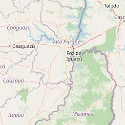
Use this park location map to pinpoint Tatí Yupí Refuge in Paraguay, understand its exact geographic position, and read its mapped placement within the surrounding landscape more clearly.

Pigeon | © OpenStreetMap contributors

Location context for Tatí Yupí Refuge

Alto Paraná Department

Explore protected area views, riverfront terrain, and native subtropical habitats.

Tatí Yupí Refuge Photos and Landscapes, Visualizing Subtropical Forest Scenery

Visual documentation captures the diverse terrain, dense forests, and reservoir edges that define Tatí Yupí Refuge. Examining field photography helps researchers and travelers understand the ecological character and protected landscape features of the reserve.

A dirt path lined by two rows of tall palm trees leading toward a large lake under a clear blue sky.

Park atlas

Compare surrounding regional geography and connected subtropical forest landscapes

Explore Protected Areas and Other Notable Parks Near Tatí Yupí Refuge

Continue exploring protected areas and natural habitats linked to the Paraná basin after reviewing Tatí Yupí Refuge. Comparing adjacent reserves reveals the broader ecological distribution of lowland forests and river ecosystems across the region.
Natural monumentAlto Paraná Department
About 33 km away#1 closest

South

Moisés Bertoni Scientific Monument: Protected Atlantic Forest in Alto Paraná, Paraguay

Natural monument and historic research landscape

Explore the geographic footprint of Moisés Bertoni Scientific Monument, an essential protected area in the Alto Paraná Department. This site safeguards mature Atlantic Forest ecosystems along the Paraná River while preserving the historic research station and cultural legacy of its founder. The monument remains a pivotal landmark for understanding the biodiversity and conservation landscape of eastern Paraguay.

Area
1.99 km²
Established
1955
Relief
Lowland
Climate
Subtropical
National parkMisiones Province
About 35 km away#2 closest

Southeast

Iguazú National Park: Argentina's Misiones Province Protected Landscape Atlas

Explore mapped boundaries and regional geography.

Iguazú National Park serves as a key protected natural area situated within Misiones Province. This MoriAtlas entry details its mapped geographic boundaries, contributing essential context for understanding its landscape identity. Users can explore how this national park fits into the regional geography, providing a factual basis for detailed atlas-based study of protected lands and their unique terrain.

Area
677 km²
Established
1934
IUCN
II
Relief
Lowland
State or regional parkMisiones Province
About 59 km away#3 closest

Southeast

Urugua-í Provincial Park: Exploring the Atlantic Forest Landscapes of Misiones Province

A regional atlas of protected watersheds and forest corridors

Spanning from the rolling lowlands of the Urugua-í River to the rugged slopes of the Sierra de la Victoria, this protected area represents one of the most significant forest blocks in the region. Examine the mapped drainage patterns, watershed connectivity, and forest mosaic that define this essential Argentine conservation landscape.

Area
840 km²
Established
1990
IUCN
II
Relief
Upland
National parkParaguay
About 77 km away#4 closest

South

Ñacunday National Park National Park: Paraguay's Protected Landscape and Mapped Boundaries

Explore its unique geography and protected terrain.

Gain a precise understanding of Ñacunday National Park, a designated national park in Paraguay. This entry focuses on its role as a protected landscape, detailing its geographic attributes and mapped boundaries. It serves as a vital resource for users seeking specific information on the park's natural terrain and its contribution to Paraguay's conservation geography, facilitating structured discovery within the atlas.

Area
20 km²
Established
1993
Relief
Mixed relief
Climate
Subtropical
A soft watercolor illustration depicting a serene landscape with rolling green hills, scattered trees, and a winding stream under a warm, light-colored sky.
Wildlife reserveCanindeyú Department
About 113 km away#5 closest

North

Refugio Carapá Wildlife Reserve: Mapping Biological Diversity in Canindeyú Department

A protected sub-tropical mosaic along the Paraná River basin

Refugio Carapá protects a dramatic stretch of mountain slopes and riverine valleys in the Department of Canindeyú. By managing a mosaic of tall forests, swamps, and open camp vegetation, the reserve maintains a crucial ecological link within the wider Itaipu reservoir landscape. The area functions as a research-focused environment dedicated to preserving native flora and threatened species in eastern Paraguay.

Area
32.5 km²
Established
1984
Relief
Mountain
Climate
Subtropical
A soft watercolor illustration of a landscape with green grassy fields in the foreground, calm water in the midground, and gentle rolling hills in the background under a pale, pinkish sky.
Nature reserveCanindeyú Department
About 161 km away#6 closest

Northwest

Mbaracayú Forest Nature Reserve: A Detailed Geographic Atlas of Paraguay's Protected Forest

Mapped terrain, forest corridors, and landscape features

Spanning over 64,000 hectares in the Canindeyú Department, Mbaracayú Forest Nature Reserve preserves the core of the Alto Paraná Atlantic forest. The area features a complex mosaic of subtropical forest, riparian corridors, and the undulating slopes of the Cordillera de Mbaracayú range. This map-focused profile details the reserve's unique topography, stream networks, and its vital role as a continuous wilderness block in eastern Paraguay.

Area
644.05 km²
Established
1991
IUCN
II
Relief
Upland
National parkItapúa Department
About 163 km away#7 closest

Southwest

San Rafael National Park: National Park Protected Landscape & Geographic Overview

Discover the mapped boundaries and regional setting in Itapúa.

San Rafael National Park is a significant protected area designated as a national park in Paraguay's Itapúa Department. This page serves as an atlas-centric entry point, offering a detailed view of its geographic scope, mapped park boundaries, and its role as a conservation landscape. Users can explore the park's terrain and its place within the regional geography for a structured understanding of its protected status.

Area
693.04 km²
Established
1992
IUCN
II
Relief
Upland
State or regional parkMisiones Province
About 173 km away#8 closest

South

Esmeralda Provincial Park: Protected Forest Landscapes and Geography in Misiones

A critical node in the Alto Parana Atlantic forest ecosystem

Esmeralda Provincial Park represents a significant protected area within the Misiones Province, acting as a core unit for the Yaboti Biosphere Reserve. The terrain is characterized by dense subtropical forest and rugged topography shaped by the Yaboti Guazu drainage network. This area serves as a primary site for forest biodiversity research, highlighting the ecological value of continuous, undisturbed forest tracts within the broader Argentine Mesopotamia region.

Area
316.19 km²
Established
1997
IUCN
II
Relief
Upland

Common questions about visiting, size, designation, and location context for Tatí Yupí Refuge

Tatí Yupí Refuge FAQs for park facts, access, geography, and protected area context

Find quick answers about Tatí Yupí Refuge, including protected-area facts, park geography, trail and visitor context, and how the park fits into its surrounding country and regional landscape.
MoriAtlas Explorer

Continue Your Protected Areas Search Across the Global Atlas

Deepen your exploration by continuing the structured search for national parks and protected areas worldwide. Utilize the comprehensive filtering capabilities to compare different conservation landscapes and refine your understanding of global park geography. Discover more about the distribution and characteristics of protected natural areas.

Global natural geography