Mori Atlas logo
Wildlife reserveFishhooks Wilderness

Understanding the mapped boundaries and arid terrain of the Gila River desert corridor

Fishhooks Wilderness: A Detailed Geographic Survey of Arizona Desert Protected Landscapes

Fishhooks Wilderness encompasses over 10,000 acres of rugged southeastern Arizona terrain, serving as a vital protected area within the National Wilderness Preservation System. This landscape features a complex transition between arid Sonoran desert vegetation and riparian corridors near the Gila River. Through our structured atlas mapping, users can analyze the topography and geographic distribution of this remote wilderness, which remains shielded from development as a pristine backcountry sanctuary.

wilderness areadesert landscaperiparian corridorGila River basinBLM landssoutheastern Arizona

Fishhooks Wilderness

Wildlife reserve

Park overview

Structured park overview, official facts, and landscape profile for Fishhooks Wilderness

Fishhooks Wilderness park facts, protected area profile, and essential visitor context

Review the core facts for Fishhooks Wilderness, including designation, size, terrain, visitor scale, habitats, and operating context in one park-focused overview.

About Fishhooks Wilderness

Fishhooks Wilderness occupies a quiet corner of southeastern Arizona where the arid basin-and-range terrain meets the Gila River system. Although it is a relatively small wilderness by Arizona standards, it carries the full weight of the National Wilderness Preservation System designation, meaning its lands are managed to preserve their wild, undeveloped character in perpetuity.

The wilderness is administered by the Bureau of Land Management, the federal agency responsible for vast tracts of western public land outside the National Park and National Forest systems. BLM wilderness areas tend to be more modest in scale and infrastructure than their National Park counterparts, and Fishhooks fits that pattern: there are no developed visitor facilities, no paved roads, and only lightly marked boundaries. Its value lies in the landscape itself and in the solitude it affords.

Geographic context is central to the wilderness's identity. It sits in Graham County, with Safford serving as the nearest significant town. The drive from Safford crosses the Gila River and follows a graded dirt road north along the river for many miles before branching into rougher ranch tracks that approach the wilderness boundary. The Diamond Bar Ranch sits near the area, with two roads branching from the ranch headquarters defining parts of the wilderness edge.

The wilderness's border with the San Carlos Indian Reservation is one of its most distinctive features. Reaching Fishhooks Wilderness requires crossing reservation land, and the San Carlos Apache tribal government controls the recreation permitting process for that access. This makes entry more involved than for typical public wilderness areas and reinforces the land's character as a shared borderland between federal, tribal, and ecological domains.

Ecologically, the area lies in the transition zone between the Sonoran Desert to the west and the Chihuahuan Desert influences of southeastern Arizona, with vegetation likely shaped by elevation, aridity, and proximity to the Gila River. The river itself acts as a major ecological thread in the region, supporting riparian habitat that contrasts sharply with the surrounding upland desert. Protecting an unbroken stretch of this desert-riparian interface gives Fishhooks Wilderness value beyond its acreage.

Quick facts and research context for Fishhooks Wilderness

Fishhooks Wilderness is a federally designated wilderness area in Graham County, Arizona, managed by the U.S. Bureau of Land Management. It covers roughly 10,500 acres within the National Wilderness Preservation System and is classified as an IUCN Category Ib protected landscape, reflecting its wilderness-level protection status.

The wilderness lies about 30 miles northwest of Safford, Arizona, and shares a boundary with the San Carlos Indian Reservation. Access requires crossing reservation land, meaning visitors must coordinate with the San Carlos Apache tribal authority before entering the area.

Protection and recognition

Explore the terrestrial protection scope and official administrative designations

Fishhooks Wilderness Protection Status and Documented Recognition Data

Examine the documented protection status and terrestrial conservation scope established for Fishhooks Wilderness. Review available designation records and recognized international frameworks associated with this protected landscape.

Protection details

Protection scope
Terrestrial
Transboundary protection
No
Park context

Deeper park guide and search-rich context for Fishhooks Wilderness

Fishhooks Wilderness history, landscape, wildlife, and travel context

Explore Fishhooks Wilderness through its history, landscape character, ecosystems, wildlife, conservation priorities, cultural context, and seasonal travel timing in a structured park guide built for atlas discovery and search intent.

Why Fishhooks Wilderness stands out

Fishhooks Wilderness is primarily known for its remote desert setting along the Gila River corridor in southeastern Arizona. Its protected wilderness character, governed by the Bureau of Land Management, preserves an undeveloped stretch of Sonoran-Chihuahuan desert landscape typical of the region but increasingly rare in an unmodified state. The area is also notable for the unusual access arrangement that requires crossing the San Carlos Apache Indian Reservation, giving the wilderness a distinctive jurisdictional and cultural borderland quality that sets it apart from more accessible Arizona wilderness areas.

Fishhooks Wilderness history and protected-area timeline

Fishhooks Wilderness was established as part of the broader American wilderness preservation movement that, beginning with the Wilderness Act of 1964, set aside federal lands to remain undeveloped. As a Bureau of Land Management wilderness area, it was designated under the National Wilderness Preservation System, which extends wilderness-level protection to qualifying BLM lands in addition to National Forest and National Park System holdings.

BLM wilderness designations in Arizona were the product of decades of land-use reviews beginning in the late 1970s, in which individual tracts of public land were evaluated for wilderness character and, where appropriate, formally protected. Fishhooks Wilderness emerged from this process as a recognized wildland within the Gila River watershed.

The wilderness's long history of association with the adjacent San Carlos Indian Reservation has shaped both its cultural and administrative identity. The reservation lands predate the wilderness designation by many generations, and continued tribal governance over those lands directly affects public access. While the wilderness itself is federally managed, approaching it means moving through a landscape with deep and continuing indigenous presence, where the San Carlos Apache remain the primary land stewards on the reservation side of the boundary.

A working ranching tradition also remains visible in the area, with Diamond Bar Ranch headquarters still located near the wilderness boundary and dirt roads defined partly by ranch operations. This blend of active ranching, tribal land management, and federal wilderness protection gives the area a layered land-use history rather than a purely untouched backcountry biography.

Fishhooks Wilderness landscape and geographic character

The landscape of Fishhooks Wilderness is classic southeastern Arizona arid country: sparse, sun-baked, and shaped by long-term erosion across volcanic and sedimentary terrain. The region's basin-and-range topography creates alternating ridges, low hills, and broad desert flats typical of the area between the Gila River and the higher ranges further north. Travelers approaching from Safford pass through deeply arid lowlands before the land begins to climb gradually toward the wilderness boundary.

The Gila River plays a defining role in the area's scenery. Although the river itself does not cross the wilderness interior in any obvious way, its corridor frames the approach and supplies the riparian contrast that shapes the region's ecological transitions. North of the river, the terrain transitions into the rougher upland desert that the wilderness was set aside to protect.

Within the wilderness boundary, the country appears largely unbroken. There are no trails network of note and no formal scenic overlooks, meaning the landscape reads as a continuous expanse of desert vegetation, rocky ground, and undulating topography. Occasional boundary signs mark the transition from ranch and reservation lands into federally protected wilderness.

The lack of dramatic named landmarks gives Fishhooks Wilderness a different feel from Arizona's better-known parks. Rather than centering on a single iconic feature like a canyon or peak, it offers a generalized desert wilderness experience: distance, quiet, open sky, and the subtle patterning of desert vegetation across irregular terrain.

Fishhooks Wilderness ecosystems, habitats, and plant life

Fishhooks Wilderness sits in one of the most ecologically distinctive parts of Arizona, where the warmer Sonoran Desert flora meets the warmer, shrubbier vegetation typical of Chihuahuan-influenced zones to the east. The result is a transitional plant community shaped by elevation, aridity, and proximity to the Gila River. Creosote bush, various acacias, mesquite, and a mix of desert grasses and forbs are likely elements of the upland vegetation, while the river corridor supports denser riparian growth that contrasts with the surrounding openness.

The wilderness's modest size and proximity to the Gila River mean that habitat diversity within the protected area is shaped primarily by topography and moisture gradients rather than dramatic elevation changes. Small drainages and rockier slopes create microhabitats where vegetation cover and species composition shift over short distances, a pattern that gives even relatively small wilderness areas in this region meaningful ecological character.

Because the surrounding region is increasingly affected by development, livestock use, and invasive species, the protected designation here provides an important role in maintaining intact desert habitat continuity. Even though Fishhooks is not a large reserve, its wilderness status limits roads, mechanized use, and most forms of development, helping preserve long-term ecological integrity.

Fishhooks Wilderness wildlife and species highlights

Wildlife in and around Fishhooks Wilderness reflects the broader fauna of southeastern Arizona's desert and riparian zones. The combination of upland desert habitat and the nearby Gila River corridor supports a mix of species typical of the region, including desert-adapted mammals, birds tied to both arid uplands and riverine habitat, and reptiles common to the Sonoran-Chihuahuan transition.

The Gila River functions as a wildlife corridor, concentrating birdlife and mammal activity along its banks. Raptors such as hawks and eagles are likely drawn both to the open desert for hunting and to the riparian zone for nesting opportunities. Mule deer and javelina are among the larger mammals typical of this terrain, while smaller species such as coyotes, foxes, bobcats, and a variety of rodents occupy the uplands.

Reptiles are a constant presence across this kind of desert terrain, and the rocky, sparsely vegetated ground provides habitat for lizards and snakes that are well adapted to the region's temperature extremes. The riparian fringe near the Gila also draws migratory birds, particularly during seasonal passages, when the river corridor functions as a green thread through otherwise dry country.

Because the wilderness is small and undeveloped, wildlife there is generally less disturbed than in heavily visited desert parks, though the working ranch lands and reservation borders surrounding it mean wildlife movement crosses multiple jurisdictional and land-use boundaries.

Fishhooks Wilderness conservation status and protection priorities

Conservation significance at Fishhooks Wilderness comes primarily from its formal designation under the National Wilderness Preservation System and its management by the Bureau of Land Management. This places the area in the highest tier of protection available to BLM lands, restricting road construction, mechanized travel, and most forms of development in order to preserve the area's wilderness character.

For southeastern Arizona, where desert habitat is increasingly fragmented by agriculture, ranching, energy development, and urban expansion around Safford and other growing towns, even modest wilderness areas provide meaningful refugia for native species and ecological processes. Fishhooks Wilderness contributes to that network by maintaining an unbroken block of arid upland habitat connected ecologically, if not always administratively, to the broader Gila River watershed.

Coordination between the Bureau of Land Management and the San Carlos Apache tribal government is a central part of conservation management here, since tribal lands separate most visitors from the wilderness itself. Effective protection therefore depends not just on federal wilderness policy, but also on continuing intergovernmental cooperation over access, recreation, and land use along the reservation border.

The wilderness also serves as a place where long-standing land uses such as ranching and tribal management meet modern conservation designations, illustrating how western wilderness preservation often overlays, rather than replaces, prior human relationships with the land.

Fishhooks Wilderness cultural meaning and human context

Fishhooks Wilderness sits adjacent to the San Carlos Indian Reservation, home to the San Carlos Apache, whose governance of the surrounding lands deeply shapes how the wilderness is accessed and experienced. The reservation predates the wilderness designation by many generations, and San Carlos Apache jurisdiction over recreational permitting on reservation land is a present-day reality for anyone seeking to enter Fishhooks.

This borderland position gives the area a distinct cultural dimension that many wilderness areas lack. Rather than being surrounded entirely by federal public land, Fishhooks is framed by tribal sovereignty, ranching operations, and the deep indigenous heritage of the Gila River region. The Gila River basin more broadly carries centuries of Apache, and earlier Indigenous, presence, and the land itself holds memory of that history even where surface evidence is subtle.

Ranching culture is also part of the area's living context. The Diamond Bar Ranch remains an active operation near the wilderness boundary, and the roads used to approach the wilderness were originally ranch infrastructure. This blend of working ranch, tribal land, and federally designated wilderness creates a layered cultural and land-use landscape that differs from more purely protected park settings.

Top sights and standout views in Fishhooks Wilderness

Fishhooks Wilderness stands out for its unusual combination of Bureau of Land Management wilderness protection, adjacency to the San Carlos Apache Indian Reservation, and location along the Gila River corridor southeast of Safford. Few Arizona wildernesses combine all three elements in such a compact setting.

Its protected status under the National Wilderness Preservation System, its IUCN Category Ib designation, and its intact desert character make it a meaningful backcountry landscape for travelers interested in southeastern Arizona's quieter wildlands. Although small, it represents the kind of undeveloped, lightly visited terrain that defines the American wilderness ideal in practice.

Best time to visit Fishhooks Wilderness

The most comfortable seasons for visiting southeastern Arizona desert wilderness are typically late fall, winter, and early spring, when temperatures are milder and the desert climate is easier to travel through on foot or by vehicle. Summer in this region is extremely hot, often exceeding temperatures suited to backcountry travel, and is generally a difficult time for outdoor activity in exposed desert terrain.

Spring can also bring wildflower and grass responses to winter precipitation, giving the usually sparse vegetation a brief seasonal flush of color and life. Late fall through early spring is widely favorable for visitors focused on hiking, solitude, and observing the desert landscape under cooler, more pleasant conditions.
Monthly climate preview

Long-term representative temperature and precipitation patterns across the year

Fishhooks Wilderness Climate Normals and Monthly Weather Records

Representative coordinate measurements reveal how monthly average temperatures and precipitation shift across the annual cycle at Fishhooks Wilderness. Detailed twelve-month climate normals provide a complete breakdown of temperature extremes and precipitation averages for this protected terrain.
Annual mean16 °C
6 °C27 °C
Jan
Feb
Mar11°
Apr15°
May20°
Jun26°
Jul27°
Aug26°
Sep23°
Oct17°
Nov10°
Dec
Warmest month
July

27.1 °C

Coolest month
December

5.7 °C

Wettest month
August

2.2 mm/day

Driest month
June

0.3 mm/day

Park location guide

Geography guide, regional context, and park location map for Fishhooks Wilderness

Fishhooks Wilderness park geography, regions, and map view in United States of America

Understand where Fishhooks Wilderness sits in United States of America through a broader geographic reading of the surrounding landscape, nearby location context, and its mapped position within the national park landscape.

How Fishhooks Wilderness fits into United States of America

The United States of America is a federal presidential republic and one of the world's largest countries by area and population. It consists of 50 states across a vast territory spanning multiple time zones, with its capital in Washington, D.C. and largest city in New York City. The nation has a diverse economy, influential political system, and significant cultural and military presence globally.

Wider geography shaping Fishhooks Wilderness in United States of America

The United States occupies a vast territory in North America, bordered by Canada to the north and Mexico to the south. The 48 contiguous states stretch from the Atlantic to the Pacific Ocean, while Alaska occupies the northwestern region and Hawaii is an archipelago in the Pacific. The country encompasses diverse terrain including the Rocky Mountains, Appalachian Mountains, Great Plains, and extensive river systems.

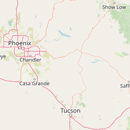
Map view of Fishhooks Wilderness

Use this park location map to pinpoint Fishhooks Wilderness in United States of America, understand its exact geographic position, and read its mapped placement within the surrounding landscape more clearly.

Pigeon | © OpenStreetMap contributors

Location context for Fishhooks Wilderness

ArizonaGraham County
Park atlas

Compare regional protected areas and connected arid terrain across southeastern Arizona

Exploring Parks Near Fishhooks Wilderness and Surrounding Desert Landscapes

Browsing nearby protected areas helps reveal the wider desert topography and basin-and-range corridors surrounding Fishhooks Wilderness. Comparing these contiguous wildlands expands regional geographic context beyond a single backcountry sanctuary.
Wildlife reserveArizona
About 60 km away#1 closest

West

Needle's Eye Wilderness: Protected Desert Geography and Mescal Mountain Topography

Gila River canyons and limestone desert landscapes in Arizona

Needle's Eye Wilderness encompasses a rugged segment of the Mescal Mountains where the Gila River has incised deep limestone gorges. This protected area features a striking shift between harsh arid uplands and a dense riparian corridor, offering a study in concentrated desert canyon topography and dramatic geological formations within southern Arizona.

Area
35.5 km²
Established
1990
IUCN
Ib
Relief
Mountain
A soft watercolor painting of a wide, rolling mountain landscape with muted greens, yellows, and purples.
Wildlife reserveArizona
About 67 km away#2 closest

Southwest

Galiuro Wilderness: A Protected Mountain Landscape in Southeastern Arizona

Mapped geography and terrain of the Galiuro range

Trace the uplifted slabs and eroded canyons that define Galiuro Wilderness. This protected area rises from the Arizona plains to reveal a complex geography of brushy slopes, spring-fed riparian zones, and sky-high summit vistas.

Area
309 km²
Established
1932
IUCN
Ib
Relief
Mountain
Protected landscapeArizona
About 69 km away#3 closest

Northwest

Tonto National Forest: Understanding the Geography of an Expansive Protected Landscape

Exploring the vertical ecosystem gradients in Central Arizona

Spanning from arid Sonoran basins to the towering Mogollon Rim, Tonto National Forest offers a unique study in vertical geography and protected land management. This expansive territory provides a vital map of Southwest life zones, encompassing reservoir systems, rugged river canyons, and critical wilderness habitat that define the environmental identity of the region.

Area
11,627 km²
Established
1905
Visitors
5.9M annual
Relief
Mountain
A horizontal watercolor painting showing distant mountains in shades of purple, soft green rolling hills, a central winding river or stream, and grassy foreground elements on a white background.
Protected landscapeNew Mexico
About 87 km away#4 closest

East

Gila National Forest: A Geographic Overview of New Mexico's Protected Wilderness Core

Mapped terrain, forest boundaries, and regional wilderness character

Gila National Forest stands as a critical protected landscape in New Mexico, encompassing immense mountain ranges, narrow river gorges, and extensive backcountry basins. This atlas entry details the forest's topographic transition from high-altitude ponderosa stands to desert lowlands, highlighting its status as the foundational site for the global wilderness movement and a stronghold for regional ecological diversity.

Area
10,969.7 km²
Established
1905
Relief
Mountain
Climate
Temperate
A horizontal watercolor illustration showing green foreground vegetation, rolling light green hills in the midground, and purple hazy mountains in the background against a white sky.
Wildlife reserveNew Mexico
About 108 km away#5 closest

East

Gila Wilderness: An In-Depth Look at the Protected Landscape and Geography of New Mexico

Mapped terrain, alpine peaks, and diverse forest ecosystems within the American Southwest

The Gila Wilderness stands as a primary case study in landscape conservation, protecting a massive network of unroaded river canyons and forest-covered mountains in New Mexico. This region serves as a bridge between temperate montane zones and arid desert environments, creating a unique ecological atlas defined by significant altitudinal gradients, volcanic features, and extensive watershed networks across the Mogollon range.

Area
225,820 km²
Established
1924
IUCN
Ib
Relief
Mountain
National parkPima County
About 119 km away#6 closest

Southwest

Saguaro National Park: Discover Its Protected Landscape Geography and Mapped Boundaries

Explore the natural terrain and regional context of this national park.

Saguaro National Park offers a focused exploration of a specific protected landscape, highlighting its unique geographic features and mapped boundaries within Pima County. This detail page provides an atlas perspective, allowing for a deep dive into the park's natural terrain and its regional significance. Understand the protected area's identity and its place within the wider geographical context.

Area
371.16 km²
Established
1994
IUCN
II
Visitors
946.4K annual
A watercolor illustration of a wide desert landscape with soft, pastel-colored mountains, arid terrain, and sparse desert vegetation against a bright sky.
Wildlife reserveUnited States of America
About 123 km away#7 closest

Southwest

Pusch Ridge Wilderness: Wildlife Reserve and Sky Island Geography in Arizona

Protecting diverse habitats from Sonoran desert lowlands to high mountain forests.

Located in the Santa Catalina Mountains, Pusch Ridge Wilderness preserves a significant vertical gradient of ecosystems. This wildlife reserve features steep canyons and granite uplifts, providing an essential habitat for Desert Bighorn Sheep while illustrating the distinct Sky Island geography found across the southern Arizona region.

Area
228.36 km²
Established
1978
Relief
Mountain
Climate
Arid
A horizontal watercolor painting depicting a desert landscape with mountains in the distance, soft green and yellow foreground vegetation, and several yucca plants.
Protected landscapeUnited States of America
About 126 km away#8 closest

Southwest

Rincon Mountain Wilderness: Geographic Atlas and Protected Landscape Overview

Sky island ecosystems and mountainous desert terrain in Arizona

This protected landscape encompasses the core of the Rincon Mountains, defining a classic triangular range oriented southwest to northeast. The wilderness serves as a vital ecological bridge, rising from arid Sonoran lowlands to cool, high-elevation montane forests. Its boundaries protect an intricate system of ridges and canyons that support isolated relict plant communities, offering a distinct study in regional desert mountain geography.

Relief
Mountain
Access
Moderate access
Scope
Terrestrial
Water
Minor water

Common questions about visiting, size, designation, and location context for Fishhooks Wilderness

Fishhooks Wilderness FAQs for park facts, access, geography, and protected area context

Find quick answers about Fishhooks Wilderness, including protected-area facts, park geography, trail and visitor context, and how the park fits into its surrounding country and regional landscape.
MoriAtlas Explorer

Continue Your Protected Areas Search Across the Global Atlas

Deepen your exploration by continuing the structured search for national parks and protected areas worldwide. Utilize the comprehensive filtering capabilities to compare different conservation landscapes and refine your understanding of global park geography. Discover more about the distribution and characteristics of protected natural areas.

Global natural geography