Mori Atlas logo
Protected areaForêt classée de Kou

A vital riverine mosaic ecosystem preserved within the Sudano-Sahelian landscape of Houet Province

Forêt classée de Kou: Mapping the Gallery Forest and Protected Landscapes of Burkina Faso

Forêt classée de Kou represents a significant protected area in Burkina Faso, serving as a rare refuge for Guinean-type forest structures in a region dominated by savanna. Spanning 115 hectares, this site centers on the riparian corridors of the Kou and Guinguette rivers, where dense gallery woodland thrives in contrast to the surrounding arid plains. The geography encompasses a distinctive mosaic of riverine vegetation, open woodland, and savanna, which together support a high concentration of bird species and maintain essential hydrological functions for the nearby city of Bobo-Dioulasso.

gallery forestGuinean forestclassified forestprotected areaBurkina Fasoornithology

Forêt classée de Kou

Protected area

Park overview

Structured park overview, official facts, and landscape profile for Forêt classée de Kou

Forêt classée de Kou park facts, protected area profile, and essential visitor context

Review the core facts for Forêt classée de Kou, including designation, size, terrain, visitor scale, habitats, and operating context in one park-focused overview.

About Forêt classée de Kou

The Forêt classée de Kou combines the roles of protected area, ecological refuge, water source, and recreational destination within easy reach of Bobo-Dioulasso. Although it occupies only about 115 hectares, it is disproportionately significant because it preserves a kind of vegetation that has otherwise largely disappeared from Burkina Faso's Sudano-Sahelian countryside: a Guinean-type gallery forest, watered by permanent river systems and structured by clear vegetation zones.

Within the forest, the Kou River and the Guinguette create a dense ribbon of tall gallery woodland, where trees can reach approximately 30 meters in height. This dense core gives way inward to a more open woodland of lower canopies and scattered light, including a managed teak plantation associated with the classified forest itself. Around the margins, the vegetation softens into arborescent savanna, where grasses dominate the understory. The forest is therefore not just a single habitat but a small, compressed mosaic of Sudano-Sahelian and Guinean vegetation types.

Ecologically, the site has national importance. It is listed among the most significant natural sites in Burkina Faso's fifth National Report on Biological Diversity, alongside the Sourou Valley, the Oursi Wetland, and Ouagadougou's Bangr-Weogo Urban Park. Its rivers support fish populations, and Crocodiles, pythons, agoutis, hares, and other small mammals live in and around the forest. Fishing is strictly forbidden within the forest's waterways. Birdlife is particularly varied, with about 164 recorded species that include both waterbirds along the rivers and terrestrial species in the woodland and savanna zones.

The forest also has a strong practical and cultural role. The Kou River is one of the main tributaries of the Mouhoun (Black Volta) and irrigates rice cultivation downstream, while contributing to the drinking water supply of Bobo-Dioulasso. Recognized infrastructure for visitors includes four thematic marked trails, two suspended bridges across the rivers, rest areas with benches and bins, ethno-botanical interpretive panels beside identifiable trees, and parking and welcome areas kept outside the forest core to concentrate impact. The Guinguette natural pool, just at the forest's edge, completes the forest's identity as an ecotourism site.

Quick facts and research context for Forêt classée de Kou

The Forêt classée de Kou is a classified protected area in the Houet Province of Burkina Faso, situated about 20 km north of Bobo-Dioulasso along a paved road past the Polytechnic University. Covering around 115 hectares, it was formally classified in 1951 under the colonial administration of French Upper Volta, as part of broader French West African forest protection policy. It is one of the most biodiversity-rich classified forests around Bobo-Dioulasso, recognized for its birdlife and as one of the few surviving Guinean-type forests in the country.

Protection and recognition

Documented terrestrial protection history and international recognition scope

Forêt classée de Kou Protection Status and Historical Designation Timeline

Forêt classée de Kou maintains a documented terrestrial protection status established in nineteen fifty-one. Official records outline the historical designation timeline and management scope without supplementary international recognition sources.

Protection details

Protection scope
Terrestrial
Designated year
1951
Transboundary protection
No
Park context

Deeper park guide and search-rich context for Forêt classée de Kou

Forêt classée de Kou history, landscape, wildlife, and travel context

Explore Forêt classée de Kou through its history, landscape character, ecosystems, wildlife, conservation priorities, cultural context, and seasonal travel timing in a structured park guide built for atlas discovery and search intent.

Why Forêt classée de Kou stands out

The forest is best known for being one of the rare surviving stands of Guinean gallery forest within a predominantly Sudano-Sahelian country, and for the diversity of its birdlife. Roughly 164 bird species have been recorded across aquatic and terrestrial habitats, making the site a recognized destination for ornithology in Burkina Faso. Equally distinctive is its layered vegetation structure: a dense riverine gallery forest along the Kou and Guinguette rivers, a more open interior woodland that includes a planted teak stand, and arborescent savanna along the forest edge. Beyond its ecology, the forest is also well known locally for la Guinguette, a natural swimming pool on the Guinguette River that has become one of the signature leisure spots around Bobo-Dioulasso and anchors the forest's ecotourism appeal.
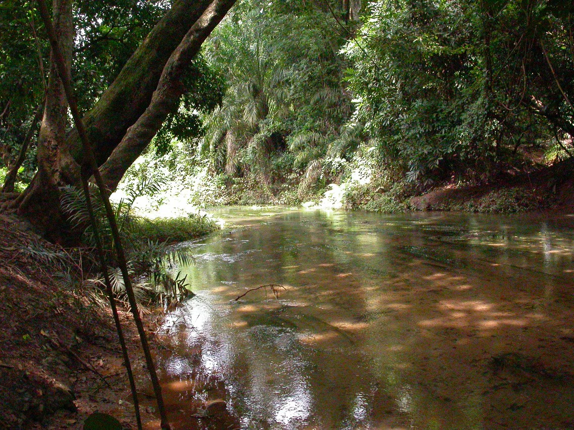
A calm river or stream flowing through a forested area, with trees lining both banks and a large tree leaning over the water on the left side, dappled sunlight reflecting on the water surface.
A calm river flowing through the dense vegetation of the Kou Classified Forest in Burkina Faso.

Forêt classée de Kou history and protected-area timeline

The forest was formally classified as a protected area in 1951, under the French colonial administration of Upper Volta (Haute-Volta). This classification was part of the broader French West African policy of protecting representative forest massifs, and in Kou's case it was explicitly aimed at safeguarding both a rare type of vegetation, Guinean gallery forest in an otherwise Sudano-Sahelian setting, and the headwater sources that feed the drinking water supply of Bobo-Dioulasso.

Since independence, the forest has remained an officially classified protected area, managed as a state asset and used in part for sustainable forestry through an in-forest teak plantation. In 2024, rehabilitation works were carried out on the forest's enclosing wall to maintain the physical integrity of the protected perimeter. The site also continues to be referenced in national biodiversity reporting, where it is identified as one of the country's important natural areas alongside sites such as the Sourou Valley, the Oursi Wetland, and the Bangr-Weogo Urban Park in Ouagadougou.

Forêt classée de Kou landscape and geographic character

The landscape of the Forêt classée de Kou is unusually varied for such a small protected area. Rather than a single uniform block of woodland, it functions as a compressed mosaic: dense gallery forest hugging permanent rivers, a more open wooded interior, and a savanna fringe.

Hydrography shapes the site. The Kou River, a major tributary of the Mouhoun (Black Volta), and the smaller Guinguette River cut through the forest. Around these waterways the gallery forest forms a thick, multi-layered belt of tall trees, some reaching roughly 30 meters in height, producing deep shade and closed canopies. Inward from this riparian core the woodland transitions into a lighter structure with gaps that allow more light through, including a planted teak stand managed by the forest administration itself. Towards the edges, the cover opens into arborescent savanna, where grass species dominate the ground layer.

Outside the forest, the broader region around Bobo-Dioulasso is shaped by more typical Sudano-Sahelian conditions, making the forest's greener profile visually striking in the surrounding countryside and ecologically significant as a refuge of more humid woodland types.

Forêt classée de Kou ecosystems, habitats, and plant life

Ecologically, the Forêt classée de Kou is significant because it preserves a small but functioning example of Guinean-type forest vegetation within Burkina Faso's predominantly Sudano-Sahelian landscape. Its protected status, dating to 1951, means that vegetation patterns inside the boundary contrast sharply with the more open countryside outside.

Vegetation clearly differentiates into three zones: a dense gallery forest along the Kou and Guinguette rivers, dominated by tall trees and multistrata canopy; a more extensive open woodland interior with lighter canopies and an associated teak plantation managed by the forest; and an arborescent savanna at the forest edge with grassy ground cover. This zonation creates a gradient from humid riparian forest to dry savanna within just a few hundred meters.

Aquatic habitats are also integral to the site. The Kou and Guinguette rivers sustain fish populations and provide wet-season and dry-season aquatic environments, even though fishing is prohibited within the protected area. Along with the woodland mosaic, these rivers create the structural variety that supports a wide range of fauna and gives the forest its particular ecological character in a country where such humid forest remnants are rare.

Forêt classée de Kou wildlife and species highlights

Wildlife is one of the forest's defining features. The site is internationally recognized for its birdlife, with around 164 recorded bird species combining waterbirds associated with the rivers and terrestrial species spread across the woodland and savanna zones. This concentration of species within a relatively small area has made the forest a notable ornithological site within Burkina Faso.

Reptiles and mammals are also present in the forest. Nile Crocodiles inhabit the river systems, alongside pythons and other snake species. Agoutis, Cape hares, and other small mammals move through the woodland and savanna fringes. Fish live in the rivers, although fishing is strictly forbidden inside the protected area.

The combination of waterbirds, terrestrial birds, crocodiles, snakes, and small forest mammals gives the site a recognizable character as a multi-habitat refuge, where relatively dense Guinean-type forest vegetation supports faunal diversity that would otherwise be largely absent from the surrounding Sudano-Sahelian landscape.

Forêt classée de Kou conservation status and protection priorities

Conservation significance at the Forêt classée de Kou operates at several levels. Nationally, the site is identified as one of the most important natural areas in Burkina Faso and is explicitly listed in the country's fifth National Report on Biological Diversity alongside sites such as the Sourou Valley, the Oursi Wetland, and the Bangr-Weogo Urban Park in Ouagadougou.

Ecologically, the protected area preserves vegetation types that have largely disappeared from the wider landscape. Because Burkina Faso is overwhelmingly Sudano-Sahelian, the survival of a Guinean-type gallery forest here is treated as a conservation priority in itself, both for its genetic and habitat value and for the refugia it provides for forest-associated species.

The forest has practical conservation functions beyond biodiversity: the Kou River supplies drinking water to Bobo-Dioulasso and irrigates downstream rice cultivation, which is why the PROGIRE integrated water resource management program has specifically flagged the protection of the riverbanks and the Kou gallery forest as important. The 2024 rehabilitation of the forest's perimeter wall reflects ongoing physical maintenance of the protected boundary, and the strict prohibition of fishing inside the forest's rivers underscores its management as a living ecological reserve rather than a purely exploitable resource.

Forêt classée de Kou cultural meaning and human context

Although primarily framed as an ecological site, the Forêt classée de Kou has meaningful local cultural dimensions. It is strongly woven into the identity of Bobo-Dioulasso, Burkina Faso's second-largest city, both as a nearby natural retreat and through la Guinguette, the natural swimming pool on the Guinguette River that has become a signature leisure spot for residents and visitors. Planting ethnobotanical interpretive panels along the trails reflects an effort to connect the forest's plant life to local knowledge and uses.

Regionally, the forest's ecological role also connects to everyday life: rice cultivation downstream depends on the Kou River, and the river itself contributes to the city's water supply. These practical ties link the protected area to the agricultural rhythms and residential life of the Houet region in ways that distinguish it from more remote reserves.

Top sights and standout views in Forêt classée de Kou

The most distinctive highlights of the Forêt classée de Kou are its compact mosaic of vegetation zones, its dense gallery forest along the Kou and Guinguette rivers, and its exceptional record of birdlife within a Sudano-Sahelian country. The teak plantation within the classified forest itself adds a managed forestry dimension that is unusual among purely passive reserves.

Equally notable are the visitor-facing elements: four themed interpretive trails, two suspended bridges crossing the rivers, ethno-botanical signage, and la Guinguette natural pool at the forest's edge. The site's accessibility, just 20 km from Bobo-Dioulasso via a paved road past the Polytechnic University, amplifies its function as one of the most approachable protected natural areas in Burkina Faso.

Best time to visit Forêt classée de Kou

The dry season, roughly from November through April, generally offers the most accessible conditions for visiting the Forêt classée de Kou. Trails and forest roads are easier to traverse, suspended bridges and rest areas are reliably usable, and the open-canopy sections of woodland and savanna fringe allow clearer views of birds and smaller mammals as animals concentrate near the remaining water sources.

The wet season, from approximately May through October, brings lusher vegetation and fuller rivers, deepening the forest's green character, but trails can be muddier and mosquitoes more active. The Guinguette natural pool remains attractive year-round, but visitors during hotter months often prefer early morning or late afternoon hours. For birdwatchers, the transition periods around the beginning and end of the rains can be especially rewarding as migratory and resident species shift between aquatic and terrestrial habitats.
Monthly climate preview

Long term monthly temperature averages and precipitation rhythms for Forêt Classée de Kou

Forêt Classée de Kou Climate Normals, Annual Temperature and Precipitation Patterns

Representative coordinate records show measured monthly temperature variations alongside shifting precipitation rates across the annual cycle. Reviewing the complete twelve month profile provides detailed numerical context for long term climatic conditions.
Annual mean27 °C
24 °C31 °C
Jan25°
Feb28°
Mar31°
Apr31°
May30°
Jun28°
Jul26°
Aug25°
Sep25°
Oct26°
Nov26°
Dec24°
Warmest month
April

31.1 °C

Coolest month
December

24.1 °C

Wettest month
August

9.1 mm/day

Driest month
December

0 mm/day

Park location guide

Geography guide, regional context, and park location map for Forêt classée de Kou

Forêt classée de Kou park geography, regions, and map view in Burkina Faso

Understand where Forêt classée de Kou sits in Burkina Faso through a broader geographic reading of the surrounding landscape, nearby location context, and its mapped position within the national park landscape.

How Forêt classée de Kou fits into Burkina Faso

Burkina Faso is a landlocked West African nation. The Mossi people settled the area in the 11th and 13th centuries, establishing kingdoms such as Ouagadougou, Tenkodogo, and Yatenga. The French colonized the region in 1896 as part of French West Africa, and the country gained independence in 1960 as the Republic of Upper Volta before being renamed Burkina Faso in 1984 by President Thomas Sankara.

Wider geography shaping Forêt classée de Kou in Burkina Faso

Burkina Faso is a landlocked country in West Africa, bordered by Mali to the northwest, Niger to the northeast, Benin to the southeast, Togo and Ghana to the south, and Ivory Coast to the southwest. The terrain consists primarily of a peneplain with some laterite plateaus in the southeast. The country has several major rivers including the Mouhoun, Nakambe, and Comoé, though most are seasonal.

Map view of Forêt classée de Kou

Use this park location map to pinpoint Forêt classée de Kou in Burkina Faso, understand its exact geographic position, and read its mapped placement within the surrounding landscape more clearly.

Pigeon | © OpenStreetMap contributors

Visualizing the rare Guinean gallery forest and riverine habitats of Burkina Faso

Forêt classée de Kou Photos and Protected Area Landscapes

Examine detailed photography of Forêt classée de Kou to understand its distinct mosaic of dense riverine woodland, permanent waterways, and surrounding arborescent savanna. Visual documentation reveals the unique ecological character of this protected sanctuary within a predominantly Sudano-Sahelian region.

A calm river or stream flowing through a forested area, with trees lining both banks and a large tree leaning over the water on the left side, dappled sunlight reflecting on the water surface.

Park atlas

Compare adjacent riverine habitats, gallery woodlands, and regional conservation areas.

Exploring Parks Near Forêt Classée de Kou and Surrounding Protected Landscapes

Visitors comparing Forêt classée de Kou can examine other protected natural areas across the surrounding region. Broadening the geographic scope reveals diverse woodland types, riverine corridors, and distinct regional park characteristics.
A soft watercolor illustration showing a calm, curved wetland area with gentle green hills in the background and sparse vegetation in the foreground.
Protected areaCascades
About 74 km away#1 closest

Southwest

Lac de Tengréla Protected Area: Mapping Wetland Landscapes in the Cascades Region

Freshwater geography and regional catchment in southwestern Burkina Faso

Located near Banfora, Lac de Tengréla functions as a protected Ramsar wetland within the Comoé River system. This freshwater lake provides essential ecological value, with its elongated basin and outflow connectivity offering a distinct window into the hydrology and natural terrain of southwestern Burkina Faso.

Area
5.8 km²
Established
2009
Scope
Terrestrial
Water
Water-dominated
National parkBurkina Faso
About 169 km away#2 closest

East

Deux Balés National Park: Burkina Faso's Elephant Sanctuary and Savanna Protected Landscape

Explore mapped terrain and key geographic features of this protected area.

Deux Balés National Park serves as a vital protected area within Burkina Faso, acclaimed for harboring the largest elephant population in West Africa. This national park's protected landscape is defined by undulating granitic plains, lateritic plateaux, and distinct gallery forests lining the Black Volta River. The presence of ancient African baobab trees adds a unique visual character to the savanna ecosystem. Investigating this park reveals its significance for regional conservation, its mapped geographic boundaries, and its role within the broader context of protected lands in West Africa.

Area
810 km²
Established
1937
IUCN
II
Relief
Lowland
Watercolor illustration of a landscape with green fields, trees, and a body of water
National parkIvory Coast
About 175 km away#3 closest

South

Comoé National Park: Geographic and Environmental Overview of the Ivory Coast Reserve

Mapping the transitions of West Africa's largest protected savanna ecosystem.

Comoé National Park serves as an ecological crossroads in north-eastern Ivory Coast, protecting 11,500 square kilometers of diverse terrain. The park hosts an extraordinary gradient of habitats, from dense gallery forests hugging the 230 kilometer stretch of the Comoé River to open, dry Sudanian savannas. Its geological foundation, featuring dramatic granite inselbergs and wide plains, supports a highly complex network of life, making it a cornerstone for understanding West African regional conservation and landscape ecology.

Area
11,500 km²
Established
1983
IUCN
II
Relief
Lowland
A soft watercolor illustration showing a calm pond in the foreground, with gentle grassy hills and sparse trees in the background.
National parkIvory Coast
About 175 km away#4 closest

South

Comoé National Park: Geographic Overview and Protected Landscape Analysis

Mapping the savanna and river corridors of Ivory Coast

Comoé National Park spans the northeastern reaches of Ivory Coast, providing a crucial protected space for West Sudanian savanna and gallery forests. This large-scale reserve is characterized by the hydrological influence of the Comoé River, which carves through the undulating plains to create seasonal floodplains and dense riverine corridors that serve as essential habitat for regional wildlife populations.

Area
11,491.5 km²
Established
1968
IUCN
II
Relief
Upland
Wildlife reserveUpper West Region
About 243 km away#5 closest

Southeast

Wechiau Community Hippo Sanctuary: Protected River Landscapes and Savanna Wildlife Reserve

Upper West Region, Ghana: Riverine ecology and community-managed boundaries

Wechiau Community Hippo Sanctuary encompasses a protected stretch of the Black Volta, providing essential habitat for hippopotamuses in northwestern Ghana. This wildlife reserve features a diverse landscape of riverine forests, sandbanks, and savanna trails. The sanctuary demonstrates how local traditional governance maintains critical natural terrain while fostering an integrated cultural and ecological landscape.

Established
1999
Relief
Lowland
Scope
Terrestrial
Water
Major water bodies
Wildlife reserveUpper West Region
About 254 km away#6 closest

East

Gbele Resource Centre Wildlife Reserve: A Regional Atlas of Protected Savanna Landscapes

Mapped geography and protected woodland in Ghana

Gbele Resource Centre represents one of the most substantial protected savanna landscapes in northwestern Ghana, spanning over 500 square kilometres of Sudano-Sahelian woodland. The terrain is defined by the seasonal Kulpawn River and a distinct composition of African baobab and sycamore fig trees, which together anchor an important ecological corridor. This reserve provides a vital opportunity to map and understand the conservation geography and avian diversity that distinguish the Upper West Region from other parts of the country.

Area
565 km²
Relief
Lowland
Scope
Terrestrial
Water
Minor water
National parkSavannah Region
About 304 km away#7 closest

Southeast

Mole National Park: A Premier Protected Landscape in Ghana's Savannah Region

Explore mapped boundaries and Guinea savannah ecosystems.

Mole National Park represents a significant protected landscape within Ghana's Savannah Region, serving as the country's largest national park and a crucial conservation area for West African wildlife. The park's geography is defined by extensive Guinea savannah, characterized by grasslands with scattered woodlands and a prominent escarpment along its southern edge. Its vast expanse offers a unique opportunity to study mapped park boundaries and understand the ecosystem's role in regional conservation efforts. Discover the unique landscape context and protected area identity of this major West African wildlife refuge.

Area
4,840 km²
Established
1958
IUCN
II
Visitors
17.8K annual
Watercolor depiction of a river flowing through a landscape with green trees and distant mountains under a light sky
National parkBurkina Faso
About 332 km away#8 closest

East

Kaboré Tambi National Park: Burkina Faso's Largest National Park and Protected Landscape

Explore the mapped savanna and birdwatching geography of this vital West African area.

Kaboré Tambi National Park represents a critical protected area in Burkina Faso, spanning a considerable expanse of Sudan-Guinea savanna. The park's geography is defined by the Nazinon River and a mosaic of woodland and grassland ecosystems, making it a significant site for understanding regional protected lands and landscape ecology. It offers a valuable point of reference for atlas-based exploration of West African natural areas.

Area
1,555 km²
Established
1976
IUCN
II
Relief
Lowland

Common questions about visiting, size, designation, and location context for Forêt classée de Kou

Forêt classée de Kou FAQs for park facts, access, geography, and protected area context

Find quick answers about Forêt classée de Kou, including protected-area facts, park geography, trail and visitor context, and how the park fits into its surrounding country and regional landscape.
MoriAtlas Explorer

Continue Your Protected Areas Search Across the Global Atlas

Deepen your exploration by continuing the structured search for national parks and protected areas worldwide. Utilize the comprehensive filtering capabilities to compare different conservation landscapes and refine your understanding of global park geography. Discover more about the distribution and characteristics of protected natural areas.

Global natural geography