Mori Atlas logo
Wildlife reserveForrester Island Wilderness

Analyzing the mountainous terrain, oceanic exposure, and ecological boundaries of this isolated marine sanctuary.

Forrester Island Wilderness: A Remote Wildlife Reserve and Coastal Protected Landscape in Alaska

Forrester Island Wilderness encompasses a rugged, densely forested landscape rising sharply from the Pacific waters off the southern Alaska Panhandle. As a key component of the Alaska Maritime National Wildlife Refuge, this protected area features steep, mountainous terrain and exposed rocky shorelines that serve as critical breeding grounds for marine mammals. Discover the geographic distribution and environmental significance of this remote wilderness unit within the broader North Pacific coastal network.

wildernessislandcoastalmarine wildlifeSteller sea lionsseabirds

Forrester Island Wilderness

Wildlife reserve

Park overview

Structured park overview, official facts, and landscape profile for Forrester Island Wilderness

Forrester Island Wilderness park facts, protected area profile, and essential visitor context

Review the core facts for Forrester Island Wilderness, including designation, size, terrain, visitor scale, habitats, and operating context in one park-focused overview.

About Forrester Island Wilderness

Forrester Island Wilderness is one of the smaller and more remote designated wilderness areas in the Alaska Maritime National Wildlife Refuge system, anchored on a single forested island about 20 miles west of Dall Island off the southern Alaska Panhandle. The wilderness covers approximately 2,832 acres, a footprint that is compact in absolute terms but ecologically significant because of its position in the Gulf of Alaska and its long history as a protected refugium for marine wildlife.

The island itself stretches roughly 5.2 miles in length and reaches elevations of about 814 feet, producing a landscape that combines steep coastal slopes with dense coastal forest cover. Because much of the island is inaccessible by land and surrounded by often challenging Pacific waters, the wilderness retains a strongly unmodified character, with limited human footprint and natural processes largely intact across both its terrestrial and nearshore environments.

The defining reason Forrester Island Wilderness exists today is its value to marine wildlife, particularly Steller sea lions, which use the island's rocky shoreline for seasonal rookeries. This biological role has been recognized for more than a century and is the direct reason the island was first protected as a federal refuge in 1912, long before formal wilderness designation. The 1970 inclusion of the area in the National Wilderness Preservation System reflected a growing national emphasis on preserving exemplary wild lands and reinforced protection for the surrounding marine habitat essential to the island's wildlife.

In modern terms, the wilderness is best understood as a small but ecologically critical piece of a much larger maritime refuge system. Its compact size, isolation, and concentrated wildlife value allow it to punch well above its acreage in contributing to biodiversity conservation in the North Pacific.

Quick facts and research context for Forrester Island Wilderness

Forrester Island Wilderness lies in the Gulf of Alaska off the southerntip of the Alaska Panhandle, within the Prince of Wales-Hyder Census Area. The wilderness encompasses about 2,832 acres, covering most of Forrester Island and adjacent rocks and islets, and was designated in 1970.

The protected area is administered as part of the Alaska Maritime National Wildlife Refuge and is most notable for its Steller sea lion rookeries, its forested mountainous terrain, and its history as one of Alaska's earliest island refuges, originally established in 1912.

Protection and recognition

Examine the established protected area designation, management framework, and historical conservation timeline.

Forrester Island Wilderness Protection Status and Designation History

Forrester Island Wilderness holds a mixed protection scope backed by a 1970 designation year and documented administrative records. Detailed conservation profiles provide a reliable reference for evaluating management frameworks and recognized protected area boundaries.

Protection details

Protection scope
Mixed
Designated year
1970
Transboundary protection
No
Park context

Deeper park guide and search-rich context for Forrester Island Wilderness

Forrester Island Wilderness history, landscape, wildlife, and travel context

Explore Forrester Island Wilderness through its history, landscape character, ecosystems, wildlife, conservation priorities, cultural context, and seasonal travel timing in a structured park guide built for atlas discovery and search intent.

Why Forrester Island Wilderness stands out

Forrester Island Wilderness is best known as a breeding and hauling ground for Steller sea lions, whose seasonal rookeries along the island's rocky shoreline are among the most biologically significant features of the wilderness. The island's steep forested slopes, exposed Pacific coastline, and isolation create the kind of undisturbed marine mammal habitat that has drawn sustained scientific and conservation interest. Equally important to the wilderness's identity is its place within the Alaska Maritime National Wildlife Refuge, one of the most extensive marine protected-area networks in North America. This positioning has shaped its management and reinforced its role as a refuge for seabirds, marine mammals, and coastal ecosystems in a region otherwise affected by industrial activity and changing ocean conditions.
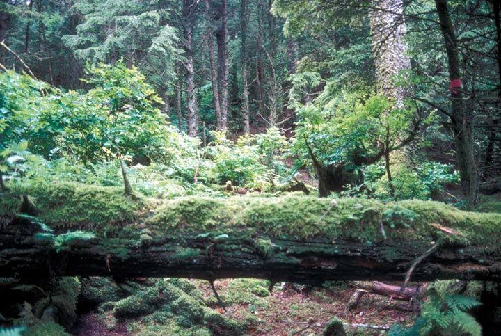
A fallen tree trunk covered in thick green moss lying horizontally across the foreground of a dense, lush, old-growth temperate forest in Alaska.
A moss-covered fallen log within the dense, lush temperate forest of Forrester Island Wilderness.

Forrester Island Wilderness history and protected-area timeline

Forrester Island carries a layered history of exploration-era naming, long predating its modern protected status. In 1774, Spanish explorer Juan Pérez recorded the island as Santa Cristina, and in 1775 Francisco Antonio Maurelle labeled it San Carlos. The British sea captain William Douglas named it Douglas Island in 1778, before Royal Navy officer George Dixon gave it the name Forrester Island in 1787, a designation adopted by George Vancouver's 1793 expedition and the one that has endured.

The first formal step toward protection came in 1912, when U.S. President William Howard Taft signed a law establishing the Forrester Island Refuge. The original refuge included Forrester Island, Lowrie Island, and Wolf Rock, recognizing even at that early date the importance of the area's seabird colonies and marine mammal populations.

In 1970, the surrounding waters and terrestrial area were designated the Forrester Island Wilderness, adding the site to the National Wilderness Preservation System. This designation aligned with the broader American movement to secure exemplary wild landscapes under permanent legal protection and incorporated the island into the framework that would later be reinforced through the Alaska Maritime National Wildlife Refuge.

Forrester Island Wilderness landscape and geographic character

Forrester Island is a compact, elongated island dominated by steep terrain and dense coastal vegetation. It rises to roughly 814 feet at its highest point, producing a mountainous profile that falls sharply toward the Pacific on nearly every side. The shoreline consists largely of rugged, exposed rock, with cliffs and rocky benches that are central to the island's character and to its ecological role as marine mammal habitat.

Vegetation across the island is dominated by temperate coastal forest typical of the Alaska Panhandle, with a continuous canopy broken only by cliffs, rocky outcrops, and active sea lion haul-outs. The combination of forested ridge tops, sheer coastal slopes, and wave-beaten shorelines creates a landscape where the boundary between land and sea is unusually sharp and visually prominent.

Surrounding the island is open North Pacific water, with no sheltering mainland nearby. This oceanic exposure shapes the wilderness's atmosphere, weather patterns, and overall sense of remoteness, contributing to the strong feeling of isolation that defines the site.

Forrester Island Wilderness ecosystems, habitats, and plant life

The ecological character of Forrester Island Wilderness is shaped by the meeting of temperate coastal forest and the open Gulf of Alaska. The island's vegetation reflects the wet, maritime climate of the southern Alaska Panhandle, with coniferous forest cover that extends down to the upper shoreline in many places.

The near-shore environment is equally important to the wilderness's natural profile, supporting kelp and intertidal communities typical of the Pacific Northwest. These habitats in turn support a broader food web that sustains seabirds and marine mammals, anchoring the island's identity as an ecological transition zone between terrestrial forest and North Pacific marine ecosystems.

Because the area has been protected for over a century, its ecological processes remain relatively undisturbed. The wilderness functions as a refuge not only for its most famous residents, the Steller sea lions, but also for seabird colonies and other species dependent on undisturbed coastal habitat.

Forrester Island Wilderness wildlife and species highlights

Forrester Island Wilderness is primarily known for its Steller sea lion rookeries, which occupy the island's rocky shoreline and represent one of the more significant concentrations of this species in the region. The presence of these rookeries has defined the island's conservation history and remains the single most important wildlife feature of the wilderness.

Scientific observations from the island include remarkable records of animal movement, including the longest recorded Steller sea lion migration, a roughly 1,600-mile journey from Forrester Island to Cape Newenham in Bristol Bay. Such records underscore both the productivity of the island's habitat and its role within a much larger regional marine mammal population.

Beyond sea lions, the surrounding waters and the island itself host seabirds and other marine wildlife typical of the Alaska Maritime National Wildlife Refuge. The wilderness's protected status and isolation contribute to its continuing importance for these species, particularly those sensitive to disturbance on breeding and haul-out sites.

Forrester Island Wilderness conservation status and protection priorities

Forrester Island Wilderness has been protected for well over a century, beginning with the establishment of the Forrester Island Refuge in 1912 under President William Howard Taft. That early refuge designation recognized the island's importance as habitat for marine mammals and seabirds long before the modern wilderness system existed.

The 1970 designation as a congressionally recognized wilderness added stronger legal protection and aligned the island with national wilderness standards emphasizing ecological integrity, natural conditions, and limits on development. As part of the Alaska Maritime National Wildlife Refuge, Forrester Island Wilderness now sits within one of the largest and most ecologically significant marine protected-area networks in North America.

From a conservation perspective, the wilderness's principal value lies in its ability to support undisturbed marine mammal habitat in a coastal region otherwise subject to varied human pressures. Steller sea lions, in particular, have faced population challenges elsewhere in their range, making protected breeding and haul-out sites like those on Forrester Island critical for long-term population resilience.

Forrester Island Wilderness cultural meaning and human context

Forrester Island has a documented Haida name, Gasḵúu, reflecting the broader cultural history of the Alaska Panhandle and the southern Panhandle region as part of longstanding indigenous homelands and travel corridors along the Pacific coast. While direct evidence of continuous habitation is limited compared to larger mainland areas, the persistence of indigenous names for places as remote as Forrester Island underscores the depth of regional knowledge and movement along this coast prior to European contact.

European exploration layers further enrich the island's cultural history. Spanish, British, and American voyages contributed a succession of names, including Santa Cristina and San Carlos in the Spanish era, Douglas Island under British maritime exploration, and finally Forrester Island, the name that survived and was eventually entrenched through George Vancouver's 1793 expedition. These overlapping naming histories make the island a small but layered example of competing imperial-era mapping traditions in the North Pacific.

Top sights and standout views in Forrester Island Wilderness

Forrester Island Wilderness stands out for the rare combination of small geographic footprint and outsized ecological importance. Its Steller sea lion rookeries are the centerpiece of its identity, supported by rocky shorelines that have been protected from disturbance for more than a century.

The island's mountainous, forested interior, its position within the Gulf of Alaska, and its integration into the Alaska Maritime National Wildlife Refuge all reinforce its value as a self-contained wilderness unit. Few wilderness areas of comparable size combine such immediate exposure to the open ocean, such dense coastal forest, and such sustained federal protection.

Best time to visit Forrester Island Wilderness

Conditions around Forrester Island are strongly shaped by the marine climate of the Gulf of Alaska, with calmest conditions typically occurring in the late spring and summer months when daylight is longest and seas are generally more workable. These seasons also correspond with peak activity at the sea lion rookeries, when seasonal wildlife presence is at its most visible.

Autumn and winter bring rougher seas, reduced daylight, and harsher weather, making the surrounding area far less conducive to visits. Any meaningful engagement with the island is generally best considered within the broader late spring through early fall window, when weather windows and biological activity coincide.

Monthly climate preview

Long term temperature and precipitation records across representative coordinate sampling

Forrester Island Wilderness Climate Normals and Monthly Weather Patterns

Representative coordinate measurements document measured monthly temperature ranges and precipitation rates for Forrester Island Wilderness across the nineteen ninety one to twenty twenty climatology period. Examining the complete twelve month profile provides deeper analytical context for long term climatic rhythm and regional variations.
Annual mean8 °C
5 °C14 °C
Jan
Feb
Mar
Apr
May
Jun11°
Jul13°
Aug14°
Sep12°
Oct10°
Nov
Dec
Warmest month
August

13.5 °C

Coolest month
February

4.7 °C

Wettest month
October

8.7 mm/day

Driest month
June

3.2 mm/day

Park location guide

Geography guide, regional context, and park location map for Forrester Island Wilderness

Forrester Island Wilderness park geography, regions, and map view in United States of America

Understand where Forrester Island Wilderness sits in United States of America through a broader geographic reading of the surrounding landscape, nearby location context, and its mapped position within the national park landscape.

How Forrester Island Wilderness fits into United States of America

The United States of America is a federal presidential republic and one of the world's largest countries by area and population. It consists of 50 states across a vast territory spanning multiple time zones, with its capital in Washington, D.C. and largest city in New York City. The nation has a diverse economy, influential political system, and significant cultural and military presence globally.

Wider geography shaping Forrester Island Wilderness in United States of America

The United States occupies a vast territory in North America, bordered by Canada to the north and Mexico to the south. The 48 contiguous states stretch from the Atlantic to the Pacific Ocean, while Alaska occupies the northwestern region and Hawaii is an archipelago in the Pacific. The country encompasses diverse terrain including the Rocky Mountains, Appalachian Mountains, Great Plains, and extensive river systems.

Map view of Forrester Island Wilderness

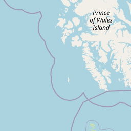
Use this park location map to pinpoint Forrester Island Wilderness in United States of America, understand its exact geographic position, and read its mapped placement within the surrounding landscape more clearly.

Pigeon | © OpenStreetMap contributors

Location context for Forrester Island Wilderness

Alaska

Explore photographic records of steep terrain, temperate rainforests, and rocky sea lion rookeries.

Visualizing Forrester Island Wilderness: Photos of Rugged Coasts and Marine Habitats

Examine detailed visual documentation of Forrester Island Wilderness to understand its remote coastal terrain and exposed Pacific shorelines. High-resolution park imagery highlights the steep forested ridges, wave-beaten cliffs, and protected marine habitats defining this isolated refuge.

A fallen tree trunk covered in thick green moss lying horizontally across the foreground of a dense, lush, old-growth temperate forest in Alaska.

Park atlas

Compare adjacent coastal reserves and marine protected areas across the Alaska Panhandle

Parks Near Forrester Island Wilderness And Surrounding Protected Landscapes

Browse other parks and protected areas sharing similar rugged maritime terrain across the surrounding region. Continuing past Forrester Island Wilderness opens broader geographic comparisons for coastal wilderness units.
Protected landscapeBritish Columbia
About 64 km away#1 closest

South

Duu Guusd Heritage Site/Conservancy: Coastal Geography and Protected Land Map

A unified land and sea protected landscape in Haida Gwaii, British Columbia

Spanning over 227,000 hectares, Duu Guusd Heritage Site/Conservancy creates a massive protected corridor along the Pacific coast of British Columbia. This area links terrestrial forest ecosystems with marine waters, preserving complex island landscapes and significant Haida cultural sites throughout the northwestern corner of Graham Island.

Area
2,277.12 km²
Established
2008
IUCN
II
Relief
Mixed relief
A minimalist watercolor painting showing layered hills and coastal terrain in soft shades of green, gray, and pink, resembling the Alaskan wilderness.
Wildlife reserveAlaska
About 169 km away#2 closest

North

Kuiu Wilderness: An Alaska Protected Area of Temperate Rainforest and Fjord Geography

A remote wilderness expanse within the Alexander Archipelago

The Kuiu Wilderness serves as a primary example of coastal conservation in Alaska, offering a vast roadless territory that spans from sea level to alpine elevations. Mapped through a series of deep fjords and temperate rainforests, this reserve provides a critical look at the complex landscape transitions that define the ecology of the Alexander Archipelago.

Area
245.16 km²
Established
1990
Relief
Mountain
Climate
Temperate
Watercolor painting of a coastal scene with green islands, coniferous trees, and soft, hazy mountains in the background, set against a white background.
Marine protected areaBritish Columbia
About 219 km away#3 closest

East

Kitson Island Marine Provincial Park Map and Coastal Protected Area Atlas

Protected island and estuarine landscape in British Columbia

Kitson Island Marine Provincial Park encompasses a vital coastal island and the adjacent Flora Bank at the mouth of the Skeena River. This protected marine environment provides a rare example of accessible sandy beach terrain on the North Coast. Use this atlas resource to understand the park boundaries, island geography, and estuarine interface within the broader Inside Passage conservation network.

Area
0.45 km²
Established
1993
IUCN
II
Relief
Lowland
A watercolor painting showing a lake, a forested shoreline, and distant mountains in a soft palette.
State or regional parkBritish Columbia
About 227 km away#4 closest

East

Diana Lake Provincial Park: Mapping Coastal Rainforest and Wetland Geography in British Columbia

An examination of North Coast forest and freshwater ecosystems

Diana Lake Provincial Park represents a significant protected area in British Columbia, showcasing the diverse ecological character of the North Coast. The park boundary encompasses a mosaic of old-growth rainforest, open blanket bogs, and freshwater aquatic systems. By protecting these varied terrains, the region maintains vital habitats for Pacific salmon species while providing a structured landscape for understanding the wet maritime environment of the Pacific Northwest.

Area
2.33 km²
Established
1980
IUCN
II
Relief
Upland
A soft watercolor painting of a winding river flowing through a lush, green landscape with forested hills in the background.
Nature reserveBritish Columbia
About 237 km away#5 closest

East

Gamble Creek Ecological Reserve: Protected Nature Reserve Geography and Forest Map

British Columbia North Coast forest and peatland research landscape.

Situated on the North Coast of British Columbia, Gamble Creek Ecological Reserve is a designated nature reserve comprising forest and bog ecosystems. The protected area serves as an important site for studying plant communities, including sphagnum moss and coastal bog species, within a unique altitudinal transition between coastal hemlock and subalpine zones.

Area
10.26 km²
Established
1991
IUCN
Ia
Relief
Mixed relief
State or regional parkBritish Columbia
About 242 km away#6 closest

East

Khutzeymateen Provincial Park: Protected Wilderness and Coastal Forest Geography

North Coast British Columbia protected area and estuary map.

Khutzeymateen Provincial Park represents a pivotal conservation achievement on the British Columbia North Coast. This wilderness sanctuary protects a critical estuarine complex where rugged mountain ranges meet a sheltered Pacific inlet. Beyond its designation as a grizzly bear stronghold, the park holds globally significant old-growth Sitka spruce forests, providing a rare look at an intact temperate rainforest landscape.

Area
450.52 km²
Established
1994
IUCN
Ib
Relief
Mountain
State or regional parkBritish Columbia
About 247 km away#7 closest

Northeast

Lava Forks Provincial Park: Geological Mapping and Protected Area Overview

Remote volcanic wilderness in northern British Columbia

This protected area preserves the fresh geological features created by the 1904 eruption of The Volcano. The site offers a detailed look at ash dunes, lava flows, and water-filled potholes within a remote northern British Columbia setting. Use this atlas resource to examine the park boundaries and the unique terrain that characterizes this significant transboundary conservation landscape.

Area
74.63 km²
Established
2001
IUCN
III
Relief
Mountain
National parkHaida Gwaii
About 248 km away#8 closest

Southeast

Gwaii Haanas National Park Reserve and Haida Heritage Site: National Park Protected Area

Explore the mapped geography and landscape context of Haida Gwaii.

Gwaii Haanas National Park Reserve and Haida Heritage Site offers a clear view of a protected national park's landscape and geographic positioning. This page provides detailed information on its specific boundaries and its location within the Haida Gwaii region, serving as a key point for understanding protected land distribution and regional geography through an atlas lens.

Area
1,470 km²
Established
1988
IUCN
II
Relief
Mountain

Common questions about visiting, size, designation, and location context for Forrester Island Wilderness

Forrester Island Wilderness FAQs for park facts, access, geography, and protected area context

Find quick answers about Forrester Island Wilderness, including protected-area facts, park geography, trail and visitor context, and how the park fits into its surrounding country and regional landscape.
MoriAtlas Explorer

Continue Your Protected Areas Search Across the Global Atlas

Deepen your exploration by continuing the structured search for national parks and protected areas worldwide. Utilize the comprehensive filtering capabilities to compare different conservation landscapes and refine your understanding of global park geography. Discover more about the distribution and characteristics of protected natural areas.

Global natural geography