

Mori Atlas logo
National parkGeneral Juan N. Álvarez National Park

Understand the geographic setting and protected landscape of General Juan N. Álvarez National Park in Guerrero.

General Juan N. Álvarez National Park: Protected Area, Mapped Boundaries and Regional Geography

General Juan N. Álvarez National Park stands as a significant protected area within Mexico's Guerrero region. This page provides an atlas-focused view, detailing the park's mapped boundaries and its intrinsic connection to the surrounding natural landscapes. Discover the core geographic identity and protected status of this national park through structured map data and regional context, essential for understanding its place in conservation geography.

National ParkMexicoSierra Madre del SurMountain ForestGuerreroPine-Oak Forest

General Juan N. Álvarez National Park

National park

Park overview

Structured park overview, official facts, and landscape profile for General Juan N. Álvarez National Park

General Juan N. Álvarez National Park park facts, protected area profile, and essential visitor context

Review the core facts for General Juan N. Álvarez National Park, including designation, size, terrain, visitor scale, habitats, and operating context in one park-focused overview.

About General Juan N. Álvarez National Park

General Juan N. Álvarez National Park preserves a segment of the Sierra Madre del Sur mountain range in the state of Guerrero, one of Mexico's most biologically diverse regions. The park was established through a presidential decree issued on May 14, 1964, by President Adolfo López Mateos, making it one of the earlier national park designations in Mexico's modern protected area system. The terrain consists of rugged mountainous topography with elevations known collectively as El Ocotal, where slopes descend from the higher ridgelines through transitional forest zones into deeper ravines that carry seasonal water flow toward the regional river system. The park occupies land that was historically part of ejido communal holdings, and the protected area designation was established over these existing land use arrangements. The surrounding region is referred to as the Región de Montaña, reflecting the mountainous character that dominates much of southern Guerrero.

Quick facts and research context for General Juan N. Álvarez National Park

General Juan N. Álvarez National Park is situated in the Sierra Madre del Sur of Guerrero state, approximately 528 hectares in extent and established in 1964. The park protects mountain forest ecosystems at elevations reaching 2,500 meters, with the landscape characterized by pine and oak forest cover, grassland areas in lower zones, and deeply carved ravines. The protected area falls under IUCN Category II and is managed by Mexico's National Commission of Natural Protected Areas. The park sits within the hydrographic basin of the Balsas River system, serving as a watershed protection area for the region.

Protection and recognition

Verifying the terrestrial protection scope, designation framework, and global atlas records.

General Juan N. Álvarez National Park Protection Status and Designation History

Verification of General Juan N. Álvarez National Park protection status requires tracing its registered terrestrial boundaries and legal conservation framework. Geographic datasets compile official records on management scope and global designation criteria to clarify how the land is preserved within regional networks.

Protection details

Protection scope
Terrestrial
Transboundary protection
No
Park context

Deeper park guide and search-rich context for General Juan N. Álvarez National Park

General Juan N. Álvarez National Park history, landscape, wildlife, and travel context

Explore General Juan N. Álvarez National Park through its history, landscape character, ecosystems, wildlife, conservation priorities, cultural context, and seasonal travel timing in a structured park guide built for atlas discovery and search intent.

Why General Juan N. Álvarez National Park stands out

The park is best known for its mountainous pine and oak forest ecosystems in the Sierra Madre del Sur, representing a relatively small but ecologically significant protected area in Guerrero. The forest contains introduced species from reforestation efforts alongside native vegetation, with endangered orchids found in the lower zones. The area supports a diversity of wildlife including species such as ocelot, coyote, raccoon, and fox, within a landscape of steep ravines and ridgelines typical of the southern Mexican highlands.

General Juan N. Álvarez National Park history and protected-area timeline

The national park was created through decree on May 14, 1964, during the administration of President Adolfo López Mateos. This period represented an active phase in Mexico's establishment of protected natural areas, with the park among the earliest designations in the postwar era. The park was named for Juan Álvarez, a significant figure in Mexican history who served as president in the mid-19th century and participated in pivotal events including the Reform War. The selection of this name reflects the Mexican tradition of using national park designations to honor historical figures while preserving natural heritage. The park was incorporated into Mexico's national system of protected areas and is managed by the National Commission of Natural Protected Areas (CONANP), the federal agency responsible for overseeing the country's natural protected areas.

General Juan N. Álvarez National Park landscape and geographic character

The landscape of General Juan N. Álvarez National Park is defined by its position within the Sierra Madre del Sur, a major mountain range that extends along the Pacific coast of southern Mexico. The terrain consists of steep to moderately sloped mountain terrain with elevations reaching approximately 2,500 meters above sea level. The area encompasses both the higher ridgeline zones and descends through successive forest bands into deep ravines and canyons. The local name for these elevations is El Ocotal, referring to the broader mountainous zone northwest of Chilapa de Álvarez. The topography ranges from semi-flat plateau areas and rolling hills to pronounced slopes and deep ravine cuts, creating a heterogeneous landscape that supports varied ecological conditions within a relatively compact area.

General Juan N. Álvarez National Park ecosystems, habitats, and plant life

The park protects forest ecosystems characteristic of the Sierra Madre del Sur, with vegetation dominated by pine and oak forest associations. These forest types represent some of the most extensive vegetation communities in the montane zones of southern Mexico. Some of the forest cover has been influenced by reforestation efforts that introduced additional tree cover. In the lower elevation zones and valley bottoms, grassland areas occur, providing an ecological contrast to the forested slopes. The floral community includes orchids, which are noted as particularly threatened in this area, reflecting broader conservation concerns for these specialized plants. The park sits within a hydrological system where ravines collect and channel water through tributaries to the Atzacualoya River, connecting the protected area to the broader watershed that feeds into the Balsas River basin.

General Juan N. Álvarez National Park wildlife and species highlights

The park supports a diversity of mammalian species within its forest and ravine habitats. Wildlife surveys have documented the presence of several carnivore species including the ocelot, a neotropical cat species of conservation concern, as well as the bobcat, coyote, fox, and raccoon. Smaller mammals present include the skunk, opossum, rabbit, and badger. The cacomistle, a Central American carnivore related to coatis, has also been recorded in the area. This assemblage of species represents the typical mammal community found in montane forest habitats of the Sierra Madre del Sur, with the park providing protected habitat for these species within a region that otherwise faces considerable land use pressure.

General Juan N. Álvarez National Park conservation status and protection priorities

General Juan N. Álvarez National Park represents a protected area within Mexico's national park system, designated under IUCN Category II for national park protection. The park provides legal protection for the forest ecosystems and wildlife habitat found within the Sierra Madre del Sur, an ecoregion of significant biodiversity. According to national biodiversity information systems, more than 15 species of plants and animals have been recorded within the park, with at least one species recognized under Mexico's official risk listing (NOM-059). The protected status helps preserve watershed function for the regional river system while maintaining forest cover in an area that has experienced land use change in surrounding zones.

General Juan N. Álvarez National Park cultural meaning and human context

The park is named for General Juan Álvarez (1820-1881), a Mexican military leader and politician who served as president of Mexico in 1855. Álvarez played a significant role in Mexican history during the Reform War and the period of liberal reform in the mid-19th century. The naming of the protected area after this historical figure reflects the practice of commemorating national leaders through place names, a common feature throughout Mexico. The land upon which the park is situated was historically held as ejido, a form of communal agricultural land that was historically significant in rural Mexican society.

Top sights and standout views in General Juan N. Álvarez National Park

The park preserves an accessible example of Sierra Madre del Sur mountain forest within Guerrero, offering protection for pine-oak ecosystems and species including the ocelot. The area provides watershed benefits for the broader Balsas River basin through its hydrological function. The park's historical naming connects natural preservation to Mexican national history through the figure of Juan Álvarez. The combination of forest, grassland, and ravine habitats creates ecological diversity within a relatively compact protected area.

Best time to visit General Juan N. Álvarez National Park

The park is located in a subhumid temperate climate zone with an average annual temperature around 28°C. The rainy season occurs primarily from May through September, which corresponds to the summer months and coincides with the peak of the warm season. The wet period brings moisture to the forests and fills the ravines with water flow, though access may be affected by conditions during heavy rainfall. The dry season from October through April offers more stable conditions for visitation, though the park's visitor infrastructure and access details would require local consultation. The higher elevations may offer cooler conditions compared to the lower surrounding areas, particularly during the winter months.
Monthly climate preview

Tracing long-term temperature averages and monthly precipitation rhythms in Guerrero

Climate Normals and Monthly Weather for General Juan N. Álvarez National Park

Long-term meteorological data at a representative elevation of 1213 meters reveal warm daytime temperatures peaking in April alongside a highly concentrated rainy season from June through September. Accessing the complete twelve-month profile helps analyze average minimums, maximums, and daily precipitation patterns across the entire annual cycle.
Annual mean22 °C
19 °C24 °C
Jan19°
Feb21°
Mar22°
Apr24°
May24°
Jun23°
Jul22°
Aug22°
Sep21°
Oct21°
Nov20°
Dec19°
Warmest month
May

24.5 °C

Coolest month
December

19.3 °C

Wettest month
September

7.6 mm/day

Driest month
December

0.2 mm/day

Park location guide

Geography guide, regional context, and park location map for General Juan N. Álvarez National Park

General Juan N. Álvarez National Park park geography, regions, and map view in Mexico

Understand where General Juan N. Álvarez National Park sits in Mexico through a broader geographic reading of the surrounding landscape, nearby location context, and its mapped position within the national park landscape.

How General Juan N. Álvarez National Park fits into Mexico

Mexico, officially the United Mexican States, is a country in North America spanning the Sierra Madre mountain ranges, coastal plains, and tropical regions. It borders the United States to the north, Guatemala and Belize to the southeast, and has coastlines along the Pacific Ocean, Gulf of Mexico, and Caribbean Sea. With a population exceeding 130 million, Mexico is home to one of the world's most significant concentrations of Indigenous languages alongside Spanish.

Wider geography shaping General Juan N. Álvarez National Park in Mexico

Mexico occupies a land area of 1,972,550 km2, making it the thirteenth-largest country in the world. The terrain is highly diverse, featuring the Sierra Madre Occidental and Sierra Madre Oriental mountain ranges, the Mexican Plateau, coastal lowlands along the Pacific and Gulf/Caribbean margins, and the Yucatan Peninsula. The country spans multiple climate zones from desert in the north to tropical rainforest in the south.

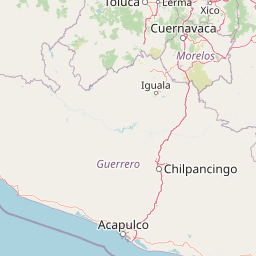
Map view of General Juan N. Álvarez National Park

Use this park location map to pinpoint General Juan N. Álvarez National Park in Mexico, understand its exact geographic position, and read its mapped placement within the surrounding landscape more clearly.

Pigeon | © OpenStreetMap contributors

Location context for General Juan N. Álvarez National Park

Guerrero
Park atlas

Discover more protected landscapes across Mexico's Sierra Madre del Sur, tracing connected mountain geography and diverse forest ecosystems.

Explore Other National Parks and Protected Areas Near General Juan N. Álvarez National Park in Guerrero

Browse other national parks and protected areas near General Juan N. Álvarez National Park, expanding your view of Mexico's mountainous Guerrero region and its conservation landscapes. Explore similar Sierra Madre del Sur mountain forest ecosystems and compare diverse protected areas, tracing how they connect within the broader regional geography.
Biosphere reserveMorelos
About 72 km away#1 closest

Sierra de Huautla Biosphere Reserve: Geography and Protected Land Atlas

Explore the seasonal tropical dry forest and volcanic mountain terrain in Morelos, Mexico.

Sierra de Huautla serves as a significant biosphere reserve in southern Morelos, showcasing a complex mosaic of tropical dry forests, gallery ecosystems, and oak-pine woodlands. This protected landscape is defined by dramatic vertical gradients and watershed functions linking the volcanic highlands to the Balsas Basin. Examine the map boundaries and terrain features that support a diverse range of wild cats, endemic bird species, and ancient Mesoamerican cultural heritage.

Area
590.31 km²
Established
1999
IUCN
VI
Relief
Mountain
National parkMexico
About 115 km away#2 closest

Southwest

El Veladero National Park: National Park Protected Landscape and Regional Geography

Explore mapped boundaries and landscape context in Mexico.

Gain a structured understanding of El Veladero National Park, a distinct national park situated within the rich geographic tapestry of Mexico. This protected area offers valuable insights into regional landscape patterns and mapped territorial boundaries, crucial for any atlas-focused exploration of Mexico's natural heritage. Discover the park's specific geographic identity and its contribution to the national protected lands network.

IUCN
II
Access
Access unknown
National parkGuerrero
About 127 km away#3 closest

North

Grutas de Cacahuamilpa National Park: National Park Identity and Geographic Context

Mapping protected landscapes and regional park geography.

Understand the essential geographic features and protected landscape characteristics of Grutas de Cacahuamilpa National Park. This canonical entry provides structured data focused on its identity as a national park within Guerrero, Mexico, and offers a foundation for map-based exploration and regional geographic context. Discover the mapped terrain that defines this conservation area.

Area
27 km²
Established
1936
IUCN
II
Visitors
350K annual
Protected areaMorelos
About 148 km away#4 closest

North

Corredor biológico Chichinautzin: Protected Area and Volcanic Highland Geography

Mapping the biological corridor between Morelos and the Mexican highlands

As a strategic biological corridor, Corredor biológico Chichinautzin preserves a rugged, volcanic landscape of pine forests and deep ravines. The protected area ensures essential connectivity between major national parks and provides a critical water source for the surrounding region, marking it as a centerpiece of ecological conservation in the central Mexican highlands.

Area
378.73 km²
Established
1988
Scope
Terrestrial
Water
Major water bodies
National parkMorelos
About 151 km away#5 closest

North

El Tepozteco National Park: Protected National Park in Morelos

Explore the mapped geography and protected landscape of this Mexican national park.

Delve into El Tepozteco National Park, a key protected area designated as a national park within the Morelos region of Mexico. This profile provides detailed insight into its mapped boundaries and its significance within the broader regional geography. It serves as a resource for understanding the park's protected landscape and its context for atlas-based geographic exploration.

Area
232.587 km²
Established
1937
IUCN
II
Relief
Mountain
National parkState of Mexico
About 160 km away#6 closest

North

Lagunas de Zempoala National Park: Protected Landscape and Geographic Atlas Entry

Explore mapped boundaries and natural terrain context.

Lagunas de Zempoala National Park is a dedicated protected area within the State of Mexico, serving as a vital point for understanding national park geography and landscape mapping. This entry provides foundational atlas data on its protected boundaries and its specific natural terrain. It is designed for users seeking structured information on the park's geographic scope and its importance as a mapped natural landscape for regional context.

Area
47.9 km²
Established
1936
IUCN
II
Relief
Mountain
National parkState of Mexico
About 172 km away#7 closest

North

Sacromonte National Park: National Park Atlas and Protected Landscape Exploration

Discover mapped boundaries and regional geographic context.

Investigate Sacromonte National Park as a key protected area within Mexico's State of Mexico. This detailed view provides insight into its designation as a national park, emphasizing its geographic setting and the characteristics of its protected landscape. Users interested in atlas-style discovery will find information that clarifies the park's physical presence and regional importance, facilitating a deeper understanding of its mapped terrain.

Area
0.44 km²
Established
1952
IUCN
II
Scope
Terrestrial
National parkMexico
About 180 km away#8 closest

North

Cumbres del Ajusco National Park: Exploring Mexico's National Park Protected Landscape

Discover mapped boundaries and regional geography.

Cumbres del Ajusco National Park is an important national park offering rich opportunities for geographic exploration. This detailed profile focuses on its identity as a protected landscape within Mexico, providing essential context for map-based discovery. Understand the park's specific location, its mapped territory, and its role within the nation's network of conservation areas, facilitating a structured atlas view.

Area
9.2 km²
Established
1936
IUCN
II
Relief
Mountain

Common questions about visiting, size, designation, and location context for General Juan N. Álvarez National Park

General Juan N. Álvarez National Park FAQs for park facts, access, geography, and protected area context

Find quick answers about General Juan N. Álvarez National Park, including protected-area facts, park geography, trail and visitor context, and how the park fits into its surrounding country and regional landscape.
MoriAtlas Explorer

Continue Your Protected Areas Search Across the Global Atlas

Deepen your exploration by continuing the structured search for national parks and protected areas worldwide. Utilize the comprehensive filtering capabilities to compare different conservation landscapes and refine your understanding of global park geography. Discover more about the distribution and characteristics of protected natural areas.

Global natural geography