

Mori Atlas logo
National parkGoongarrie National Park

Discover the protected landscape boundaries and regional geography of Goongarrie National Park.

Goongarrie National Park: National Park in Western Australia's Geographic Context

Goongarrie National Park stands as a significant protected natural area within the expansive geography of Western Australia. This dedicated national park offers a focused point for understanding regional landscapes, mapped park boundaries, and the broader context of conservation lands across Australia. Engage with its specific geographic identity and explore its role within the vast protected areas of Western Australia.

Arid Zone WoodlandsSalt LakesBiogeographic TransitionWestern AustraliaMulga-Eucalypt LineClay Pans

Goongarrie National Park

National park

Park overview

Structured park overview, official facts, and landscape profile for Goongarrie National Park

Goongarrie National Park park facts, protected area profile, and essential visitor context

Review the core facts for Goongarrie National Park, including designation, size, terrain, visitor scale, habitats, and operating context in one park-focused overview.

About Goongarrie National Park

Goongarrie National Park preserves a substantial tract of arid-zone landscape in the heart of Western Australia's Goldfields region. The park's establishment in 1978 reflected growing recognition of the need to protect representative samples of the state's inland environments, particularly those spanning biogeographic transitions that support diverse ecological communities. The park was expanded through the acquisition of former pastoral land, with Goongarrie Station purchased by the state government in 1995, adding to the protected area network in this region. The park's location approximately 94 kilometers north of Kalgoorlie places it within a landscape that has been shaped by both natural processes and historic pastoral activity. The park's significance extends beyond its biological values to include its hydrological systems, with salt lakes and clay pans providing important Wetlands in an otherwise arid landscape. These features support distinct ecological communities adapted to variable water availability and seasonal flooding, contributing to the park's biodiversity values despite the challenging climate.

Quick facts and research context for Goongarrie National Park

Goongarrie National Park spans 603.97 square kilometers in the Goldfields region of Western Australia, established in 1978 as an IUCN Category II protected area. The park lies along the mulga-eucalypt line, a recognized biogeographic boundary in arid Australia. Vegetation is dominated by acacia woodlands and eucalypt species adapted to semi-arid conditions. The northern boundary includes the southern end of Lake Marmion alongside numerous smaller salt lakes and clay pan depressions. The park was formed from land that was part of the historic Goongarrie Station, purchased by the state government in 1995. The park name derives from nearby Lake Goongarrie, of Indigenous Australian origin.

Protection and recognition

Documenting terrestrial protection scope and global conservation designations

Goongarrie National Park Protection Status and Conservation Designation

Geographic explorers can analyze the documented terrestrial boundaries and official protection status of Goongarrie National Park within the Australian conservation network. Accessing verified data points regarding terrestrial scope and framework alignment supports structured regional mapping and comparative ecological study.

Protection details

Protection scope
Terrestrial
Park context

Deeper park guide and search-rich context for Goongarrie National Park

Goongarrie National Park history, landscape, wildlife, and travel context

Explore Goongarrie National Park through its history, landscape character, ecosystems, wildlife, conservation priorities, cultural context, and seasonal travel timing in a structured park guide built for atlas discovery and search intent.

Why Goongarrie National Park stands out

Goongarrie National Park is best known for its position along the mulga-eucalypt line, a biogeographic boundary that defines the transition between different arid-zone vegetation communities in Western Australia. The park protects representative examples of arid zone woodlands dominated by acacia and eucalypt species, with the added ecological significance of encompassing salt lake and clay pan systems at its northern end. The landscape represents a critical transition zone between the Coolgardie and Murchison bioregions, two of Australia's recognized interim biogeographic regions, making it valuable for understanding aridland ecological patterns. The area also encompasses the abandoned historic townsite of Goongarrie, adding historical dimension to its protected landscape.

Goongarrie National Park history and protected-area timeline

Goongarrie National Park was officially established in 1978, entering the network of Western Australia's national parks during a period of expanding protected area coverage in the state. The park's land history is closely tied to pastoral use, with the area originally forming part of Goongarrie Station, a large grazing property in the Goldfields region. In 1995, the state government purchased the pastoral lease, integrating the land into the formal protected area system. Also located within the park boundaries is the abandoned townsite of Goongarrie, a relic of earlier settlement attempts in this remote interior region. The park's name originates from Lake Goongarrie, a prominent geographic feature in the area, with the name derived from Indigenous Australian language. Infrastructure within the park receivedUpgrade in 2007 following government funding of 70,000 Australian dollars, improving visitor facilities and management capacity for this remote protected area. The Department of Environment and Conservation, now part of the state's environmental management framework, has overseen the park's management since its establishment.

Goongarrie National Park landscape and geographic character

The landscape of Goongarrie National Park exemplifies the arid interior of Western Australia, characterized by open woodlands, salt lake basins, and extensive clay pan systems. The terrain is generally flat to gently undulating, with the vegetation dominated by acacia species forming the backbone of the woodland structure. Eucalypts occur throughout the park, reflecting the park's position along the mulga-eucalypt line, a biogeographic boundary that marks where mulga woodlands transition to more open eucalypt-dominated communities. At the northern end of the park, the southern portions of Lake Marmion provide a dramatic landscape feature, with this large salt lake representing one of the region's most significant wetland systems. Smaller salt lakes and clay pans are scattered throughout the park, creating a complex of hydrological features that fill seasonally and support distinctive ecological communities. The combination of woodland canopy and open salt lake basins creates a visually distinctive semi-arid landscape.

Goongarrie National Park ecosystems, habitats, and plant life

The ecological character of Goongarrie National Park is defined by its position in the transition zone between the Coolgardie and Murchison bioregions, two of Australia's Interim Biogeographic Regionalisation for Australia regions. This transitional position means the park supports vegetation communities from both biogeographic regions, increasing its ecological diversity and significance. The park's vegetation is dominated by acacia woodlands, particularly various species of Acacia adapted to low-rainfall conditions, with eucalypts providing canopy cover in more open areas. The mulga-eucalypt line that passes through the park represents a well-documented biogeographic boundary in southwestern Australia, where rainfall patterns and soil conditions create distinct vegetation zones. The salt lakes and clay pans at the northern end of the park support different ecological communities adapted to periodically flooded and saline conditions, adding habitat diversity to the overall park environment. These wetlands attract waterbirds during seasonal filling events and provide important ecological functions in the arid landscape.

Goongarrie National Park conservation status and protection priorities

Goongarrie National Park contributes to the conservation of Western Australia's arid-zone biodiversity by protecting representative examples of the Coolgardie and Murchison bioregions within a formal protected area. The park's position along the mulga-eucalypt line adds conservation significance, as this biogeographic boundary supports distinct vegetation communities that would be poorly represented without protection. The salt lake and clay pan systems within the park provide habitat for specialist wetland species adapted to the boom-and-bust hydrology of arid Australia, with these features functioning as important refuges during wet periods. By preserving the transition between two bioregions, the park protects ecological gradients and the species adapted to intermediate conditions, contributing to regional biodiversity persistence. The acquisition of former pastoral land for inclusion in the park reflects ongoing efforts to expand protected area coverage in Western Australia's inland regions, addressing historical gaps in representation of arid-zone environments.

Goongarrie National Park cultural meaning and human context

The cultural context of Goongarrie National Park includes both Indigenous Australian heritage and more recent historical settlement. The park's name derives from Lake Goongarrie, with the toponym originating from Indigenous Australian language, though the specific meaning of the name is not recorded in available sources. The park encompasses the abandoned townsite of Goongarrie, representing a phase of European settlement attempts in the remote Goldfields region during the late nineteenth and early twentieth centuries. This historic settlement provides a tangible link to earlier periods of regional development, though the townsite is no longer active. The broader landscape has been inhabited by Aboriginal peoples for thousands of years, with the Goldfields region containing significant Indigenous cultural heritage despite the challenges of documenting this history in arid environments.

Top sights and standout views in Goongarrie National Park

Goongarrie National Park's defining highlight is its biogeographic significance as a transition area between the Coolgardie and Murchison bioregions along the mulga-eucalypt line. The park protects a landscape of arid zone woodlands with acacia and eucalypt vegetation, complemented by salt lake and clay pan systems at its northern end including Lake Marmion. The combination of woodland and wetland environments creates a park of ecological complexity unusual for arid inland Australia. The historic abandoned townsite within the park adds a human heritage dimension to the natural landscape, while the park's substantial size of over 600 square kilometers ensures protection of viable ecological communities in a region where intact natural environments face multiple pressures.

Best time to visit Goongarrie National Park

Goongarrie National Park can be visited year-round, though the cooler months from May to September offer more comfortable conditions for exploring the park's landscapes. Summer temperatures in the Goldfields region can be extreme, with daytime conditions potentially limiting outdoor activity. Winter brings milder temperatures and potentially more pleasant viewing conditions for the park's woodlands and salt lakes. The wet season, typically occurring in the first half of the year in this part of Western Australia, may transform the salt lakes and clay pans into water-filled wetlands, creating different visual and ecological experiences. The timing of visits may be influenced by the desire to see particular conditions, such as wet-season wetland habitats or dry-season woodland landscapes.
Monthly climate preview

Long term temperature trends and precipitation cycles across the Western Australia interior

Goongarrie National Park Climate Normals and Average Weather by Month

Long term data from a representative elevation of 395 meters shows a dry climate with high temperature extremes exceeding 40 degrees Celsius alongside cool mid year minimums. Accessing the complete monthly profile reveals precise precipitation trends and historical temperature bounds for geographic analysis.
Annual mean19 °C
11 °C28 °C
Jan28°
Feb27°
Mar24°
Apr20°
May15°
Jun12°
Jul11°
Aug12°
Sep16°
Oct20°
Nov23°
Dec26°
Warmest month
January

28.1 °C

Coolest month
July

10.9 °C

Wettest month
February

1.7 mm/day

Driest month
September

0.4 mm/day

Park location guide

Geography guide, regional context, and park location map for Goongarrie National Park

Goongarrie National Park park geography, regions, and map view in Australia

Understand where Goongarrie National Park sits in Australia through a broader geographic reading of the surrounding landscape, nearby location context, and its mapped position within the national park landscape.

How Goongarrie National Park fits into Australia

Australia is a constitutional monarchy and federal parliamentary democracy comprising six states and ten territories. With a population of nearly 28 million, it is one of the world's most urbanised countries, with most people concentrated on the eastern seaboard. The country has a high Human Development Index and is known for its cultural diversity, ancient Aboriginal heritage, and unique wildlife.

Wider geography shaping Goongarrie National Park in Australia

Australia occupies the entire Australian continent, the island of Tasmania, and numerous smaller islands. It is the world's flattest and driest inhabited continent, featuring vast deserts in the interior (the Outback), tropical rainforests along the eastern coast, and a coastline bordering the Indian and Pacific Oceans.

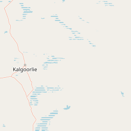
Map view of Goongarrie National Park

Use this park location map to pinpoint Goongarrie National Park in Australia, understand its exact geographic position, and read its mapped placement within the surrounding landscape more clearly.

Pigeon | © OpenStreetMap contributors

Location context for Goongarrie National Park

Western Australia
Recorded earthquake history

View Recorded Seismic Activity Near Goongarrie National Park

Explore the historical catalogue of earthquakes associated with the landscape of Goongarrie National Park through the MoriAtlas seismic discovery tool. Analyze event data and epicentre distances relative to the park boundaries in the Goldfields region of Western Australia.

Goongarrie National Park Earthquake History

Catalogued events

1 event

Strongest magnitude

Magnitude 3.2

Most recent event

Jul 24, 2002

This history includes earthquakes recorded inside the park or within 50 km of its borders

Park atlas

Explore the diverse arid zone woodlands and salt lake systems in Western Australia, expanding your discovery beyond Goongarrie National Park.

Compare National Parks and Protected Areas Near Goongarrie National Park in Western Australia

Explore additional national parks and protected areas within Western Australia's Goldfields region, revealing more of the arid interior's unique conservation landscapes. Comparing these sites provides a deeper understanding of Goongarrie National Park's ecological context, including its distinctive arid zone woodlands, salt lake systems, and biogeographic significance.
National parkGoldfields-Esperance
135 km away#1 closest

Southwest

Goldfields Woodlands National Park: Explore Protected Area Geography and Mapped Boundaries

Discover the mapped landscape context of this national park.

Delve into Goldfields Woodlands National Park, a key protected area within the Goldfields-Esperance region. This resource provides detailed atlas-style information, focusing on the park's mapped geography, its protected status, and its role within the broader regional landscape. Understand its specific topographic features and its place in the natural atlas.

Area
646.28 km²
Established
2000
Climate
Arid
Scope
Terrestrial
National parkWestern Australia
159 km away#2 closest

Southwest

Boorabbin National Park: Exploring Western Australia's National Park Landscape and Boundaries

Mapped protected area context within Western Australia's geography.

Boorabbin National Park represents a distinct protected landscape within the expansive geography of Western Australia. This entry provides focused insight into the park's identity as a national park, highlighting its specific mapped boundaries and its contribution to the regional atlas of protected areas. Understanding Boorabbin National Park's geographic setting allows for a deeper appreciation of Western Australia's natural terrain and conservation efforts.

Area
281.53 km²
Established
1977
IUCN
II
Relief
Upland
National parkWestern Australia
293 km away#3 closest

South

Frank Hann National Park: Explore Its Protected Area Geography and Mapped Boundaries

Western Australia's protected national park landscape.

Frank Hann National Park is a designated national park providing crucial insight into Western Australia's protected natural landscapes. This entry focuses on its precise geographic scope and mapped boundaries, allowing for detailed atlas-based exploration. Understand the park's identity as a protected area and its position within the broader regional geography of this large Australian state, ideal for focused landscape discovery.

Area
675.5 km²
Established
1970
IUCN
II
Relief
Lowland
National parkWestern Australia
300 km away#4 closest

South

Peak Charles National Park: A National Park in Western Australia's Mapped Landscape

Discover its protected area status and geographic setting.

Peak Charles National Park is a vital component of Western Australia's protected natural areas. This dedicated page provides an atlas-centric view, focusing on the park's geographic scope, its mapped boundaries, and the surrounding regional landscape context. It serves as an essential resource for understanding the park's protected land identity and its contribution to the broader geography of Western Australia.

Area
399.59 km²
Established
1979
IUCN
II
Relief
Mountain
Watercolor painting of green rolling hills and purple mountains under a pastel sky
National parkWestern Australia
387 km away#5 closest

South

Cape Arid National Park: A National Park Atlas Entry for Western Australia's Coast

Explore its mapped terrain and protected landscape identity.

Cape Arid National Park, located in Western Australia, is a substantial protected area notable for its striking coastal geography. This national park features a dramatic intersection of the Southern Ocean coastline with ancient granite landforms and low hills, creating a diverse mapped terrain. Its significance extends to being a key habitat for numerous bird species, making it a critical component of the regional protected-area network and a valuable point of study within the broader geographic atlas.

Area
2,794.46 km²
Established
1969
IUCN
II
Relief
Mixed relief
National parkWestern Australia
408 km away#6 closest

South

Stokes National Park National Park: Mapped Boundaries and Regional Geography

Western Australia's protected landscape identity.

Stokes National Park represents a significant protected entity within the expansive geography of Western Australia. This detailed page provides users with essential mapping information, focusing on the park's designated boundaries and its role within the broader atlas of Australian conservation landscapes. Explore the specific geographic context that defines this national park and understand its natural landscape features.

Area
97.26 km²
Established
1976
IUCN
II
Relief
Lowland
Nature reserveWestern Australia
About 413 km away#7 closest

West

Mount Gibson Sanctuary Nature Reserve: Western Australia Protected Landscape Atlas

Regional geography and ecological transition zones

Located north-east of Perth, Mount Gibson Sanctuary serves as a vital nature reserve representing the complex boundary between the Wheatbelt and Australia's arid rangelands. The property features a mosaic of rocky ranges, claypans, floodplains, and sandplains that support significant bird and mammal populations within a carefully managed conservation framework.

Area
1,305 km²
Established
2001
Relief
Upland
Climate
Arid
Marine protected areaWestern Australia
420 km away#8 closest

South

South-west Corner Marine Park: An Atlas of Deep-Sea Landscapes and Marine Protected Areas

Western Australia offshore marine and seabed geography

South-west Corner Marine Park represents one of the most ecologically diverse marine reserves in Australian Commonwealth waters. Stretching from the coast of Western Australia into the depths of the Southern Ocean, the park protects unique underwater terrain including extensive reef systems, submarine canyons, and isolated plateaus. This area serves as a primary migratory corridor for whales and provides a vital, mapped environment for threatened shark and seabird populations within the regional marine food web.

Area
271,833 km²
Established
2013
Climate
Temperate
Access
Remote access

Common questions about visiting, size, designation, and location context for Goongarrie National Park

Goongarrie National Park FAQs for park facts, access, geography, and protected area context

Find quick answers about Goongarrie National Park, including protected-area facts, park geography, trail and visitor context, and how the park fits into its surrounding country and regional landscape.
MoriAtlas Explorer

Continue Your Protected Areas Search Across the Global Atlas

Deepen your exploration by continuing the structured search for national parks and protected areas worldwide. Utilize the comprehensive filtering capabilities to compare different conservation landscapes and refine your understanding of global park geography. Discover more about the distribution and characteristics of protected natural areas.

Global natural geography