Mori Atlas logo
National parkStokes National Park

Explore the mapped boundaries and regional setting of Stokes National Park in Western Australia.

Stokes National Park National Park: Geographic Context and Protected Landscape Atlas

Stokes National Park stands as a significant protected area within Western Australia, offering a unique perspective on the region's natural landscapes. This national park provides a vital point of reference for understanding conservation within the vast geographic expanse of Australia's largest state. Through detailed mapping and structured geographic data, users can explore the park's boundaries and its contribution to the regional atlas of protected lands.

coastal parkinlet and estuaryWestern AustraliaGoldfields-Esperanceheathlandsandy beaches

Stokes National Park

National park

Park overview

Structured park overview, official facts, and landscape profile for Stokes National Park

Stokes National Park park facts, protected area profile, and essential visitor context
Review the core facts for Stokes National Park, including designation, size, terrain, visitor scale, habitats, and operating context in one park-focused overview.

About Stokes National Park

Stokes National Park occupies a prominent position along the southern coastline of Western Australia, protecting a landscape defined by the presence of Stokes Inlet and its associated coastal environments. The park lies within the Goldfields-Esperance region, a vast area of southwestern Australia known for its blend of mallee woodlands, coastal heathlands, and granite outcrops. Stokes Inlet serves as the park's central geographical feature, creating an estuarine system that threads through the interior of the reserve and provides visual and ecological focus for the entire protected area. The surrounding terrain supports extensive heath and scrubland communities that dominate the park's visible landscape, with smaller areas of denser forest providing visual and ecological variety. Sandy beaches line the southern extent of the park where the coastline faces the Great Southern Ocean. The park's location on a relinquished pastoral lease gives it a layered history of use that predates its protection, with the former station identity still reflected in surviving heritage features within the park boundary.

Quick facts and research context for Stokes National Park

Stokes National Park is located on the southern coast of Western Australia within the Goldfields-Esperance region, approximately 80 kilometres west of Esperance. The park was established in 1976 and is managed by the Western Australia Department of Parks and Wildlife. It covers an area of 9,726 hectares excluding a small heritage site. The park is centred on Stokes Inlet, a coastal estuary that was named in 1848 by Surveyor General John Septimus Roe during an exploration expedition, honouring John Lort Stokes of HMS Beagle. The area was formerly part of the Fanny Cove pastoral lease, later known as Young River Station, before being returned to crown land and designated as a national park.

Park context

Deeper park guide and search-rich context for Stokes National Park

Stokes National Park history, landscape, wildlife, and travel context
Explore Stokes National Park through its history, landscape character, ecosystems, wildlife, conservation priorities, cultural context, and seasonal travel timing in a structured park guide built for atlas discovery and search intent.

Why Stokes National Park stands out

Stokes National Park is best known for Stokes Inlet, a prominent coastal estuary that dominates the park's interior and provides the area with its most distinctive character. The inlet, known by its Noongar name Bewenerup, creates a complex water body surrounded by coastal heath and accessible beaches that frame the southern edge of the park. The combination of estuarine waters, sandy shores, and the transition from heathland to forest pockets gives the park a diverse yet cohesive coastal identity that distinguishes it from other protected areas in the Esperance region.

Stokes National Park history and protected-area timeline

The land that now comprises Stokes National Park was originally known as Fanny Cove Station during its pastoral period. In 1951 the property was renamed Young River Station as part of changes to pastoral operations in the region. The property was subsequently returned to crown land status and underwent a transition to protected area status, with formal national park designation achieved by 1973 and formally established in 1976. The park takes its name from Stokes Inlet, which was named in 1848 by John Septimus Roe, the Surveyor General of Western Australia, during a five-man coastal exploration expedition. Roe selected the name to commemorate John Lort Stokes, a Royal Navy officer who had served on HMS Beagle during its survey of the Western Australian coast. Within the park boundary lies the site of the original Moir homestead, established in 1873 during the Fanny Cove Station period. These ruins were placed on a heritage register by 1993, though the structures have since been lost to fire.

Stokes National Park landscape and geographic character

The physical landscape of Stokes National Park centres on Stokes Inlet, a coastal estuary that forms the park's dominant topographic and visual feature. The inlet extends through the park creating a network of water channels and mudflats surrounded by coastal terrain. The park's vegetation is dominated by extensive coastal heath and scrubland that covers the majority of the reserve, creating a characteristic southwestern Australian vegetation profile. Scattered patches of low dense forest occur within the heathland, adding structural diversity to the landscape. Sandy beaches are found along the southern coastal margin where the park meets the Great Southern Ocean, providing a contrasting element of exposed coastline to the sheltered inlet environment. The combination of estuarine waters, heath-covered slopes, forest pockets and ocean beaches creates a landscape of considerable diversity within a relatively compact area.

Stokes National Park ecosystems, habitats, and plant life

The ecological character of Stokes National Park reflects the coastal heath and scrubland systems that dominate much of the southern Western Australian coastline. The park preserves representative examples of the region's distinctive coastal vegetation communities, characterized by tough, sclerophyllous shrubs adapted to the sandy, nutrient-poor soils and seasonal conditions of the area. The Stokes Inlet estuarine system adds ecological complexity to the park, providing habitat conditions that differ from the surrounding heath and forest areas. This mix of estuarine, heathland, forest and beach ecosystems gives the park a multifaceted ecological profile that supports various habitat types within a single protected area.

Stokes National Park conservation status and protection priorities

Stokes National Park contributes to the protection of coastal ecosystems in the Goldfields-Esperance region of Western Australia, preserving a representative sample of the area's characteristic heathland, forest and estuarine environments. The park's designation as a Category II protected area under the IUCN system reflects its primary function of conserving natural landscapes while providing opportunities for public enjoyment. By protecting the Stokes Inlet system and its surrounding coastal habitats, the park helps maintain ecological connectivity along this section of the southern Australian coast and preserves landscape diversity within the regional protected area network.

Stokes National Park cultural meaning and human context

The human history of the Stokes National Park area spans the pastoral era of European settlement, with the land formerly operating as Fanny Cove Station from the 1870s. The Moir homestead, established in 1873, represents the most substantial physical remnant of this pastoral period, though the structures have been lost to fire. The Noongar name Bewenerup for Stokes Inlet reflects the presence of Aboriginal connection to this coastal landscape prior to European settlement. The park was named to commemorate John Lort Stokes and his contributions to the coastal survey work conducted by HMS Beagle, linking the protected area to the broader history of Australian coastal exploration and mapping.

Top sights and standout views in Stokes National Park

Stokes Inlet stands as the park's principal highlight, a coastal estuary that defines the area's character and provides the visual anchor for the protected landscape. The inlet's waters, surrounded by coastal heath and accessible via the park's network of access points, offer visitors the opportunity to experience this estuarine environment. Sandy beaches along the southern coast provide beach recreation opportunities and ocean views. The remnants of the Moir homestead offer a tangible connection to the pastoral history that preceded the park's establishment, though visitors should note that these structures have been significantly impacted by fire.

Best time to visit Stokes National Park

The park can be visited throughout the year, though the southern hemisphere summer months of December through February typically offer the most comfortable conditions for outdoor exploration. Winter rainfall supports the heathland vegetation and can result in more vigorous plant growth, though conditions may be cooler and wetter. The coastal location means that weather patterns are influenced by the Southern Ocean, and visitors should be prepared for changeable conditions regardless of season.
Park location guide

Geography guide, regional context, and park location map for Stokes National Park

Stokes National Park park geography, regions, and map view in Australia
Understand where Stokes National Park sits in Australia through a broader geographic reading of the surrounding landscape, nearby location context, and its mapped position within the national park landscape.

How Stokes National Park fits into Australia

Australia is a constitutional monarchy and federal parliamentary democracy comprising six states and ten territories. With a population of nearly 28 million, it is one of the world's most urbanised countries, with most people concentrated on the eastern seaboard. The country has a high Human Development Index and is known for its cultural diversity, ancient Aboriginal heritage, and unique wildlife.

Wider geography shaping Stokes National Park in Australia

Australia occupies the entire Australian continent, the island of Tasmania, and numerous smaller islands. It is the world's flattest and driest inhabited continent, featuring vast deserts in the interior (the Outback), tropical rainforests along the eastern coast, and a coastline bordering the Indian and Pacific Oceans.

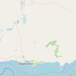
Map view of Stokes National Park

Use this park location map to pinpoint Stokes National Park in Australia, understand its exact geographic position, and read its mapped placement within the surrounding landscape more clearly.

Pigeon | © OpenStreetMap contributors

Location context for Stokes National Park

Western Australia
Park atlas

Compare Coastal Landscapes, Estuaries, and Regional Protected Areas in Western Australia

Explore More National Parks and Protected Areas Near Stokes National Park
Explore national parks and protected areas near Stokes National Park, discovering diverse coastal terrain, estuarine systems, and the characteristic heathland landscapes of Western Australia. Compare adjacent conservation efforts and trace the geographic spread of protected landscapes within the Goldfields-Esperance region, adding valuable atlas context.
National parkWestern Australia

Cape Le Grand National Park: Western Australia National Park Geographic Context and Landscape Exploration

Mapped protected area boundaries and regional natural terrain discovery.

Cape Le Grand National Park is an important national park in Western Australia, providing a distinct focus for geographic and atlas-based discovery. Understanding its protected landscape identity and its placement within the state's natural geography offers valuable insight into regional conservation areas. This page serves as a canonical entry point for exploring the mapped features and the broader geographic significance of Cape Le Grand National Park, detailed for structured atlas exploration.

Area
318.01 km²
Established
1966
IUCN
II
Relief
Mixed relief
National parkWestern Australia

Peak Charles National Park: A National Park in Western Australia's Mapped Landscape

Discover its protected area status and geographic setting.

Peak Charles National Park is a vital component of Western Australia's protected natural areas. This dedicated page provides an atlas-centric view, focusing on the park's geographic scope, its mapped boundaries, and the surrounding regional landscape context. It serves as an essential resource for understanding the park's protected land identity and its contribution to the broader geography of Western Australia.

Area
399.59 km²
Established
1979
IUCN
II
Relief
Mountain
National parkWestern Australia

Frank Hann National Park: Explore Its Protected Area Geography and Mapped Boundaries

Western Australia's protected national park landscape.

Frank Hann National Park is a designated national park providing crucial insight into Western Australia's protected natural landscapes. This entry focuses on its precise geographic scope and mapped boundaries, allowing for detailed atlas-based exploration. Understand the park's identity as a protected area and its position within the broader regional geography of this large Australian state, ideal for focused landscape discovery.

Area
675.5 km²
Established
1970
IUCN
II
Relief
Lowland
Watercolor illustration showing mountains in the background, green vegetation, and pink meadows
National parkWestern Australia

Fitzgerald River National Park: A Western Australian Protected Landscape of Global Botanical Importance

Discover its mapped terrain, endemic flora, and UNESCO Biosphere Reserve status.

Fitzgerald River National Park stands as a protected landscape of immense ecological value in Western Australia. This national park is celebrated for its extraordinary botanical diversity, featuring more endemic plant species than any other conservation reserve in Australia. Its varied terrain, from rugged mountain ranges to coastal cliffs, provides a rich tapestry of natural habitats. As a designated UNESCO Biosphere Reserve, it offers a unique opportunity to explore mapped geographic features and understand the critical role of protected areas in conserving rare flora and distinct Mediterranean ecosystems.

Area
2,972.11 km²
Established
1973
IUCN
II
Visitors
40K annual
Watercolor painting of green rolling hills and purple mountains under a pastel sky
National parkWestern Australia

Cape Arid National Park: A National Park Atlas Entry for Western Australia's Coast

Explore its mapped terrain and protected landscape identity.

Cape Arid National Park, located in Western Australia, is a substantial protected area notable for its striking coastal geography. This national park features a dramatic intersection of the Southern Ocean coastline with ancient granite landforms and low hills, creating a diverse mapped terrain. Its significance extends to being a key habitat for numerous bird species, making it a critical component of the regional protected-area network and a valuable point of study within the broader geographic atlas.

Area
2,794.46 km²
Established
1969
IUCN
II
Relief
Mixed relief
National parkWestern Australia

Hassell National Park National Park: Mapped Protected Landscape in Western Australia

Explore the geographic identity and park boundaries of Hassell National Park.

Hassell National Park offers a focused view of protected natural landscapes within Western Australia. This atlas entry details the park's specific geographic scope and its designation as a national park, providing essential context for understanding its mapped features and regional landscape. Explore how Hassell National Park contributes to the protected area geography of the state.

Area
12.65 km²
Established
1971
IUCN
II
Scope
Mixed
National parkWestern Australia

Waychinicup National Park: National Park Protected Landscape Atlas Entry

Explore Western Australia's mapped natural landscapes and park geography.

Gain a structured understanding of Waychinicup National Park as a key protected landscape within Western Australia. This detailed atlas entry focuses on its geographic distribution and mapped boundaries, providing essential context for regional park and natural landscape exploration. Discover the unique characteristics of this national park's setting and its place within the broader mapped terrain.

Area
39.82 km²
Established
1990
IUCN
II
Relief
Mixed relief
National parkGoldfields-Esperance

Goldfields Woodlands National Park: Explore Protected Area Geography and Mapped Boundaries

Discover the mapped landscape context of this national park.

Delve into Goldfields Woodlands National Park, a key protected area within the Goldfields-Esperance region. This resource provides detailed atlas-style information, focusing on the park's mapped geography, its protected status, and its role within the broader regional landscape. Understand its specific topographic features and its place in the natural atlas.

Area
646.28 km²
Established
2000
Climate
Arid
Scope
Terrestrial

Common questions about visiting, size, designation, and location context for Stokes National Park

Stokes National Park FAQs for park facts, access, geography, and protected area context
Find quick answers about Stokes National Park, including protected-area facts, park geography, trail and visitor context, and how the park fits into its surrounding country and regional landscape.
MoriAtlas Explorer

Continue Your Protected Areas Search Across the Global Atlas

Deepen your exploration by continuing the structured search for national parks and protected areas worldwide. Utilize the comprehensive filtering capabilities to compare different conservation landscapes and refine your understanding of global park geography. Discover more about the distribution and characteristics of protected natural areas.

Global natural geography