

Mori Atlas logo
Marine protected areaSouth-west Corner Marine Park

An atlas exploration of deep-sea plateaus, submarine canyons, and offshore biological corridors

South-west Corner Marine Park: Mapping the Protected Marine Landscapes of Southern Western Australia

South-west Corner Marine Park encompasses a vast stretch of ocean and seabed situated in Commonwealth waters off the southern coast of Western Australia. This offshore reserve spans from continental shelf environments to deep abyssal plains, protecting diverse geological features including the Naturaliste Plateau, the Diamantina Fracture Zone, and the productive Albany Canyon system. By mapping these varied bathymetric formations and nutrient-rich upwelling zones, the park preserves critical migratory pathways for large whales and essential habitats for numerous threatened marine species across multiple bioregions.

marine protected areaCommonwealth watersWestern Australiadeep-sea habitatsubmarine canyonsubmarine plateau

South-west Corner Marine Park

Marine protected area

Park overview

Structured park overview, official facts, and landscape profile for South-west Corner Marine Park

South-west Corner Marine Park park facts, protected area profile, and essential visitor context

Review the core facts for South-west Corner Marine Park, including designation, size, terrain, visitor scale, habitats, and operating context in one park-focused overview.

About South-west Corner Marine Park

South-west Corner Marine Park is an immense Australian marine protected area located far enough from shore to sit in Commonwealth jurisdiction, sweeping along and well beyond the lower south west and southern coastline of Western Australia. Although it is invisible from the mainland for most visitors, the park influences the broader health of the region's marine environment by safeguarding offshore habitats, water column processes, and seabed communities that are otherwise outside the reach of coastal and state-level protection.

Geographically, the park extends from outer continental shelf environments in its eastern sections to the vast, deep offshore plains and plateaus of the southern Indian Ocean. On its eastern edge, it shares marine character with the state-managed Ngari Capes Marine Park, while further offshore it encompasses very different deepwater terrain. The diversity of seafloor environments within the park is one of its defining qualities, allowing it to function as a single reserve for processes that operate at very different depths and geographies.

The waters of the marine park sit at the boundary of several major oceanographic systems. Cold, upwelling-driven productivity driven by south coast processes meets the warm, poleward-flowing influences of the Leeuwin Current, which extends along the Western Australian coast. The result is an unusual mix of warm and cold-water habitats across relatively short spatial scales, supporting species and ecological communities that are rarely found together elsewhere.

Ecologically, the park is recognized for the biological richness produced by these processes. The Albany Canyon and Cape Mentelle upwelling zone are hotspots of productivity, drawing aggregations of whales, sharks, seabirds, and pelagic fish. The Recherche Archipelago environment within the park holds the most extensive reef areas on the southern continental shelf of the South-west Marine Region, providing breeding and resting habitat for many species.

The park's conservation importance is reinforced by its role as a multi-bioregion representation area. It incorporates elements of three provincial bioregions: the South-west Shelf Province on the continental shelf, and the South-west Transition and Southern Province in the offshore zone, together with parts of two meso-scale bioregions. This breadth means the park does not protect a single habitat type but rather an integrated cross-section of the southern Western Australian marine environment, making it an unusually comprehensive reserve within the national marine parks system.

Quick facts and research context for South-west Corner Marine Park

The South-west Corner Marine Park is a Commonwealth marine protected area off the southern coast of Western Australia, gazetted on 14 December 2013 and renamed from the South-west Corner Commonwealth Marine Reserve on 11 October 2017. It lies entirely in offshore Commonwealth waters and is one of fourteen parks in the South-west Marine Parks Network.

The park covers roughly 271,833 square kilometres of ocean and seabed, spanning a wide latitudinal band south of the lower south west and southern Australian coast. It is managed by the Director of National Parks and represents three provincial bioregions and two meso-scale bioregions, including sections of the South-west Shelf, South-west Transition, and Southern Province.

Its conservation value is anchored in internationally important whale migration and foraging habitat, deep-sea geological features such as the Diamantina Fracture Zone and Naturaliste Plateau, productive upwelling zones, and extensive reef systems associated with the Recherche Archipelago.

Protection and recognition

Examine the official marine protection scope and 2017 establishment record.

South-west Corner Marine Park Protection Status and Designation History

South-west Corner Marine Park maintains a documented marine protection status established in 2017. Review the complete operational scope and official designation records for this protected marine environment.

Protection details

Protection scope
Marine
Designated year
2017
Transboundary protection
No
Park context

Deeper park guide and search-rich context for South-west Corner Marine Park

South-west Corner Marine Park history, landscape, wildlife, and travel context

Explore South-west Corner Marine Park through its history, landscape character, ecosystems, wildlife, conservation priorities, cultural context, and seasonal travel timing in a structured park guide built for atlas discovery and search intent.

Why South-west Corner Marine Park stands out

South-west Corner Marine Park is especially known for its combination of unique deep-sea geology and globally important whale habitat. Its waters include the Diamantina Fracture Zone and Naturaliste Plateau, two isolated offshore features that are thought to support diverse and endemic deepwater communities due to their unusual seafloor structure. The park is also celebrated as a critical migratory corridor and feeding ground for large whales, including humpback, blue, sperm, and southern right whales. The productive southern waters near Albany Canyon, Cape Mentelle, and Donnelly Banks create rich feeding grounds that support not only whales but also threatened sharks, seabirds, and one of the most extensive reef systems on Australia's southern continental shelf around the Recherche Archipelago. Together, these geological, oceanographic, and biological features give the park a reputation as one of the most ecologically significant marine reserves in the southern hemisphere.

South-west Corner Marine Park history and protected-area timeline

The South-west Corner Marine Park was gazetted as a Commonwealth marine reserve on 14 December 2013, as part of a broader expansion of Australia's offshore marine protection estate. Its original designation was the South-west Corner Commonwealth Marine Reserve, reflecting its initial status under the Commonwealth marine reserves framework.

On 11 October 2017, the reserve was renamed and reclassified as the South-west Corner Marine Park, aligning it with the broader Australian marine parks system that integrates individual reserves into regional networks. Following its renaming, it became a key component of the South-west Marine Parks Network, one of several networks established to manage Commonwealth marine parks in Australia's offshore waters.

Throughout its history, the park's significance has been defined less by changes in its boundaries than by growing scientific recognition of the conservation values it contains, particularly the importance of its waters for migratory whales, threatened sharks, seabirds, and unique deep-sea geological features.

South-west Corner Marine Park landscape and geographic character

The landscape of South-west Corner Marine Park is defined entirely by ocean and seabed rather than terrestrial terrain. The park spans a vast southern arc of Western Australian offshore waters, transitioning from continental shelf environments close to the coast, through slope and rise systems, into the deep offshore plains and isolated bathymetric features far from land.

A defining physical feature of the park is its set of key ecological seafloor structures. Albany Canyon is a submarine canyon system that channels nutrient-rich waters, while the Diamantina Fracture Zone is a remote, deep-sea geological structure with unique terrain. The Naturaliste Plateau is a prominent submarine feature rising from surrounding deep ocean, and Donnelly Banks, located east of Augusta, represent shallower offshore banks with elevated productivity. Together, these formations create a varied seascape of slopes, plateaus, canyons, banks, and abyssal plains.

Productive coastal upwelling near Cape Mentelle brings cold, nutrient-rich water to the surface, supporting dense aggregations of marine life at the eastern edge of the park. Westward and southward, the waters deepen and the seafloor becomes increasingly isolated, with the Recherche Archipelago environment providing the most extensive reef development on the southern continental shelf.

South-west Corner Marine Park ecosystems, habitats, and plant life

South-west Corner Marine Park encompasses an unusually wide range of marine habitats within a single protected area. On its eastern edge, the park overlaps with shelf and slope environments that share affinities with coastal waters. Further offshore, habitat types shift into mesopelagic and bathypelagic zones, with seamounts, plateaus, and fracture zone features providing substrata for deep-sea biological communities.

The productivity of the park is strongly linked to oceanic processes. Upwelling along the southern coast and the influence of the Leeuwin Current together maintain a high level of nutrient cycling, sustaining both pelagic food webs and benthic communities. The Albany Canyon group and Cape Mentelle upwelling zone are recognized for their high productivity, while areas such as the Recherche Archipelago offer extensive reef habitat and breeding or resting aggregations for marine life.

Across these varied habitats, the park represents three provincial marine bioregions and two meso-scale bioregions, making it ecologically representative rather than narrowly focused. The combination of productive shelf habitats, deepwater features, and reef environments supports a striking breadth of ecological communities within the South-west Marine Region.

South-west Corner Marine Park wildlife and species highlights

The waters of South-west Corner Marine Park support some of the most significant marine wildlife assemblages in Australia's southern ocean. The park is internationally recognized as a migratory route for large whales, including humpback and blue whales, and is visited by migratory sperm whales as well as seasonally calving southern right whales, which use parts of the park as calving habitat.

Beyond whales, the park is an important foraging area for several threatened species. White sharks and Australian sea lions use its productive waters to feed, while seabird populations, including the threatened Indian yellow-nosed albatross and soft-plumaged petrel, as well as migratory flesh-footed shearwater, short-tailed shearwater, and Caspian tern, depend on the park for feeding grounds.

The park also supports important commercial and ecological species, most notably the western rock lobster, whose habitat within the park is recognized for its ecological role. The combination of migratory megafauna, threatened seabirds, marine mammals, and ecologically important invertebrates gives the park a particularly rich and complex wildlife profile.

South-west Corner Marine Park conservation status and protection priorities

The South-west Corner Marine Park was established to protect a range of marine conservation values that extend well beyond typical single-species or single-habitat protection. It safeguards migratory habitat for internationally significant whale populations, foraging grounds for threatened shark, seabird, and marine mammal species, and seasonal calving habitat for the southern right whale.

The park is also valued for its representativeness across multiple marine bioregions. By including areas from the South-west Shelf Province, the South-west Transition, and the offshore Southern Province, the park ensures that a broad cross-section of the southern Western Australian marine environment is conserved within Commonwealth waters.

Protection of its key ecological features is central to the park's conservation role. Albany Canyon, Cape Mentelle upwelling, the Diamantina Fracture Zone, Naturaliste Plateau, western rock lobster habitat, and the Recherche Archipelago marine environment each represent a different facet of marine biodiversity, including high productivity, unique deep-sea communities, and the most extensive reef development found on the southern continental shelf.

Top sights and standout views in South-west Corner Marine Park

South-west Corner Marine Park stands out for its combination of internationally significant whale habitat and uniquely diverse deep-sea geology. Few marine reserves encompass both a major migratory corridor for humpback, blue, and southern right whales and remote bathymetric features like the Diamantina Fracture Zone and Naturaliste Plateau.

The park's reach across multiple marine bioregions, from productive shelf waters to deep oceanic plains, makes it unusually comprehensive in ecological representation. Combined with protections for threatened white sharks, Australian sea lions, and Indian yellow-nosed albatross, the park's conservation profile extends across nearly every level of the southern Western Australian marine food web.

Best time to visit South-west Corner Marine Park

As an offshore marine protected area with no general public access, the South-west Corner Marine Park is not visited in the conventional sense. Its seasonal character matters primarily for wildlife observation, science, and conservation management rather than tourism logistics.

The cooler months of the southern hemisphere autumn and winter tend to coincide with peak biological activity, particularly southern right whale use of near-shore calving areas along the broader South-west Marine Parks Network. Spring and early summer bring warmer waters, active seabird breeding cycles, and generally calmer offshore conditions. For research and survey work, the calmer late-spring to early-autumn period often provides the most workable offshore sea conditions, while winter brings rougher seas but higher nutrient upwelling.
Monthly climate preview

Long-term temperature and precipitation averages across twelve months

South-west Corner Marine Park Climate Normals and Annual Weather Patterns

South-west Corner Marine Park exhibits a measured annual cycle of temperature and precipitation based on multi-year coordinate sampling. Examining the complete monthly climate normals provides a clearer baseline for understanding the protected marine area.
Annual mean17 °C
14 °C20 °C
Jan20°
Feb20°
Mar20°
Apr19°
May17°
Jun15°
Jul14°
Aug14°
Sep15°
Oct16°
Nov17°
Dec18°
Warmest month
February

20 °C

Coolest month
August

14.4 °C

Wettest month
August

2.2 mm/day

Driest month
December

0.7 mm/day

Park location guide

Geography guide, regional context, and park location map for South-west Corner Marine Park

South-west Corner Marine Park park geography, regions, and map view in Australia

Understand where South-west Corner Marine Park sits in Australia through a broader geographic reading of the surrounding landscape, nearby location context, and its mapped position within the national park landscape.

How South-west Corner Marine Park fits into Australia

Australia is a constitutional monarchy and federal parliamentary democracy comprising six states and ten territories. With a population of nearly 28 million, it is one of the world's most urbanised countries, with most people concentrated on the eastern seaboard. The country has a high Human Development Index and is known for its cultural diversity, ancient Aboriginal heritage, and unique wildlife.

Wider geography shaping South-west Corner Marine Park in Australia

Australia occupies the entire Australian continent, the island of Tasmania, and numerous smaller islands. It is the world's flattest and driest inhabited continent, featuring vast deserts in the interior (the Outback), tropical rainforests along the eastern coast, and a coastline bordering the Indian and Pacific Oceans.

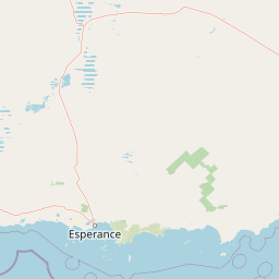
Map view of South-west Corner Marine Park

Use this park location map to pinpoint South-west Corner Marine Park in Australia, understand its exact geographic position, and read its mapped placement within the surrounding landscape more clearly.

Pigeon | © OpenStreetMap contributors

Location context for South-west Corner Marine Park

Western Australia
Recorded earthquake history

Browse the Historical Catalogue of Seismic Activity for South-west Corner Marine Park

Explore recorded earthquake data associated with the offshore regions of South-west Corner Marine Park. This MoriAtlas catalogue provides a transparent look at historical seismic events near the reserve, offering clear records for geographic analysis and regional context.

South-west Corner Marine Park Earthquake History

Catalogued events

7 events

Strongest magnitude

Magnitude 5.5

Most recent event

May 27, 2004

This history includes earthquakes recorded inside the park or within 50 km of its borders

Park atlas

Compare adjacent marine reserves and connected regional protected landscapes

Explore Other Parks Near South-west Corner Marine Park and Surrounding Protected Areas

Browse related protected areas and offshore reserves situated along the surrounding Western Australian coastline. Expanding the search helps compare regional marine bioregions and connected conservation networks beyond South-west Corner Marine Park.
National parkWestern Australia
5.5 km away#1 closest

North

Stokes National Park National Park: Mapped Boundaries and Regional Geography

Western Australia's protected landscape identity.

Stokes National Park represents a significant protected entity within the expansive geography of Western Australia. This detailed page provides users with essential mapping information, focusing on the park's designated boundaries and its role within the broader atlas of Australian conservation landscapes. Explore the specific geographic context that defines this national park and understand its natural landscape features.

Area
97.26 km²
Established
1976
IUCN
II
Relief
Lowland
National parkWestern Australia
5.5 km away#2 closest

West

D'Entrecasteaux National Park: Discover Western Australia's Protected National Park Landscape

Mapping protected boundaries and regional natural terrain.

D'Entrecasteaux National Park stands as a significant protected natural area, offering a focused lens for geographic discovery within Western Australia. This park's identity as a National Park provides a concrete point for understanding mapped landscapes and regional conservation efforts. Explore its specific boundaries and terrain to build a comprehensive picture of its role within the broader atlas of Western Australia's natural heritage.

Area
1,187.79 km²
Established
1980
IUCN
II
Visitors
168.5K annual
National parkWestern Australia
5.5 km away#3 closest

West

Walpole-Nornalup National Park: Explore Protected Landscape and Regional Geography

Mapped boundaries and natural terrain context in Western Australia.

Walpole-Nornalup National Park offers a focused lens for understanding protected landscapes. As a designated national park in Western Australia, it provides valuable insights into regional geography and mapped natural terrain. This detailed view allows for a clear appreciation of the park's specific protected area characteristics and its place within the larger geographic atlas of the state.

Area
194.48 km²
Established
1910
IUCN
II
Visitors
158.2K annual
National parkWestern Australia
5.6 km away#4 closest

West

Leeuwin-Naturaliste National Park: Western Australia's Protected Landscape and Geographic Context

Explore mapped natural terrain and protected boundaries.

Leeuwin-Naturaliste National Park provides a distinct focus for understanding protected lands within Western Australia. This national park offers rich opportunities to examine its mapped boundaries and unique landscape characteristics, contributing valuable context to the regional geography of the state. Discover the natural terrain and protected area status that define this significant location for atlas-based discovery and geographic comprehension.

Area
190.92 km²
Established
1957
IUCN
II
Visitors
2.3M annual
National parkWestern Australia
7 km away#5 closest

West

Scott National Park National Park: Mapped Protected Landscape in Western Australia

Geographic Context and Natural Terrain Discovery

Scott National Park serves as a significant protected area within the diverse geography of Western Australia. This national park provides a focal point for understanding regional landscape patterns and mapped natural features. Explore its role as a protected land, offering insight into the state's broad natural heritage and supporting detailed geographic discovery for atlas enthusiasts.

Area
32.73 km²
Established
1959
IUCN
II
Relief
Lowland
Watercolor illustration of a coastal landscape with green vegetation, pink rock formations, and a calm body of water
National parkWestern Australia
9.2 km away#6 closest

West

William Bay National Park: Mapped Protected Area in Western Australia's Geography

Explore its national park boundaries and regional landscape context.

Delve into the protected landscape of William Bay National Park, a designated national park situated within the diverse geography of Western Australia. This resource provides critical information on its mapped boundaries and its role as a protected natural area. Understand the park's specific geographic setting and its contribution to the regional atlas of conservation landscapes, essential for detailed park and landscape discovery.

Area
17.34 km²
Established
1971
IUCN
II
Visitors
238K annual
National parkWestern Australia
11 km away#7 closest

West

Wooditjup National Park: Protected Forest Landscape and Regional Geographic Context

Explore mapped boundaries of this Western Australia national park.

Wooditjup National Park stands as a testament to Western Australia's unique forest ecosystems, specifically within the Jarrah Forest bioregion. This protected area offers a distinct natural landscape contrasting with the nearby coastal attractions of Margaret River. Delve into the park's mapped geography, understand its role as a national park, and appreciate its position within the broader South West Australian landscape and its traditional Wardandi Country heritage.

Area
38.92 km²
Established
2004
IUCN
II
Relief
Lowland
National parkAustralia
12 km away#8 closest

West

Greater Hawke National Park: Mapped Boundaries of Old Growth Forest Landscape

Explore the protected forest and regional geography.

Greater Hawke National Park offers a significant atlas exploration opportunity for understanding Australia's protected forest ecosystems. This national park preserves critical old growth stands of karri and jarrah trees, showcasing the unique landscape of the Warren bioregion. Its Class A reserve status and adjacency to D'Entrecasteaux National Park highlight its importance as a conservation corridor within the South West of Western Australia. Users can examine the park's geographic setting and its protected-area identity.

Area
140.04 km²
Established
2004
Climate
Mediterranean
Access
Moderate access

Common questions about visiting, size, designation, and location context for South-west Corner Marine Park

South-west Corner Marine Park FAQs for park facts, access, geography, and protected area context

Find quick answers about South-west Corner Marine Park, including protected-area facts, park geography, trail and visitor context, and how the park fits into its surrounding country and regional landscape.
MoriAtlas Explorer

Continue Your Protected Areas Search Across the Global Atlas

Deepen your exploration by continuing the structured search for national parks and protected areas worldwide. Utilize the comprehensive filtering capabilities to compare different conservation landscapes and refine your understanding of global park geography. Discover more about the distribution and characteristics of protected natural areas.

Global natural geography