Mori Atlas logo
Nature reserveJabal Moussa Biosphere Reserve

Explore the protected boundaries and regional geography of this vital Lebanese nature reserve.

Jabal Moussa Biosphere Reserve: Lebanon's Premier Nature Reserve and Mapped Landscape

Jabal Moussa Biosphere Reserve stands as a significant protected landscape within the Keserwan District of Lebanon. This nature reserve offers a unique opportunity to explore its mapped natural terrain and understand its geographic context. As a key entity within the MoriAtlas platform, it provides detailed insights into protected area distribution and regional landscape features, making it essential for those seeking to understand Lebanon's conservation geography.

Biosphere ReserveMediterranean ForestMountain HikingArchaeological SiteBird MigrationUNESCO Protected Area

Jabal Moussa Biosphere Reserve

Nature reserve

Park overview

Structured park overview, official facts, and landscape profile for Jabal Moussa Biosphere Reserve

Jabal Moussa Biosphere Reserve park facts, protected area profile, and essential visitor context
Review the core facts for Jabal Moussa Biosphere Reserve, including designation, size, terrain, visitor scale, habitats, and operating context in one park-focused overview.

About Jabal Moussa Biosphere Reserve

Jabal Moussa Biosphere Reserve occupies a remarkable position in Lebanon's natural and cultural landscape, where the western slopes of Mount Lebanon descend toward the Mediterranean Sea. The reserve's topography creates a pronounced altitudinal gradient that supports distinct ecological zones, from oak-dominated woodlands at lower elevations through mixed coniferous forests of pine, fir, and juniper at higher elevations. This vertical stratification, combined with the site's position along bird migration flyways, has produced biodiversity levels that exceed what might be expected in such a limited area. The reserve's seven principal villages have maintained agricultural terraces, traditional land use practices, and cultural connections to the mountain that span generations, creating a landscape where human settlement and natural systems have evolved together. The UNESCO Biosphere Reserve designation in 2009 formalized a management approach that integrates scientific research, conservation, and community livelihoods through the Man and Biosphere framework, which requires each biosphere reserve to balance conservation with sustainable development and educational outreach.

Quick facts and research context for Jabal Moussa Biosphere Reserve

Jabal Moussa Biosphere Reserve covers 65 square kilometers in northern Lebanon, rising from the Mediterranean foothills to mountain peaks exceeding 1,600 meters in elevation. The reserve lies within Keserwan District and encompasses seven main villages whose residents have historically depended on the mountain's forests, springs, and agricultural terraces. The area experiences a Mediterranean climate with approximately 1,350 millimeters of annual rainfall and receives intermittent winter snowfall at higher elevations that typically melts within days. The reserve was inscribed into UNESCO's World Network of Biosphere Reserves in 2009, recognizing its exceptional biodiversity and cultural significance. Fifteen hiking trails traverse the reserve, including the historically named Hadrian's Incline, while the principal archaeological site at Qornet el Deir has revealed continuous occupation from the Bronze Age through the Ottoman period.

Park context

Deeper park guide and search-rich context for Jabal Moussa Biosphere Reserve

Jabal Moussa Biosphere Reserve history, landscape, wildlife, and travel context
Explore Jabal Moussa Biosphere Reserve through its history, landscape character, ecosystems, wildlife, conservation priorities, cultural context, and seasonal travel timing in a structured park guide built for atlas discovery and search intent.

Why Jabal Moussa Biosphere Reserve stands out

Jabal Moussa is best known for its exceptional biodiversity concentrated in a relatively small Mediterranean mountain ecosystem, supporting over 724 plant species, 25 mammal species, and more than 137 species of migratory and soaring birds. The mountain was designated a Globally Important Bird Area in 2009, recognizing its critical role in bird migration routes between Europe and Africa. The reserve is equally renowned for its archaeological wealth, with the Qornet el Deir site revealing continuous human occupation dating back to the Phoenician period and Bronze Age, interconnected with the Beqaa Valley and Mediterranean coast. Roman-era inscriptions, boundary markers, roads, and stairs survive throughout the mountain, many associated with Emperor Hadrian's declaration of the forests as imperial domain. The combination of ecological significance and historical depth makes Jabal Moussa one of Lebanon's most important protected areas.

Jabal Moussa Biosphere Reserve history and protected-area timeline

Jabal Moussa became part of the UNESCO Network of Biosphere Reserves under the Man and Biosphere program in 2009, joining a global network of protected areas that pioneer integrated approaches to conservation and development. However, human presence and protection of this mountain extend far deeper into history. The Roman Emperor Hadrian established boundary markers around the mountain's cedar, oak, cypress, fir, and juniper forests during his reign, declaring them his imperial domain and inscribing these declarations on rock faces that remain visible today. A network of Roman roads and stairs was constructed between 64 BC and AD 249, facilitating movement through the mountain while creating infrastructure that still shapes trail routes. The largest archaeological site, Qornet el Deir, has been the subject of excavations since 2017 that have revealed continuous occupation from the Bronze Age through Phoenician, Roman, Medieval, and Ottoman periods. In 2022, the U.S. Ambassador to Lebanon inaugurated the Hinterland Archaeological Heritage Project, funded by the U.S. Ambassadors' Fund for Cultural Preservation, to conserve and study the archaeological collection while connecting the various sites within the reserve.

Jabal Moussa Biosphere Reserve landscape and geographic character

The landscape of Jabal Moussa Biosphere Reserve is defined by its steep slopes descending from the Mount Lebanon mountain range toward the Mediterranean coastal plain, creating dramatic topographical variation within a relatively compact area. The reserve rises from approximately 350 meters elevation in the northwest to about 1,700 meters in the southeast, with the terrain characterized by rocky ridges, forested valleys, and numerous springs that have historically supported village settlements. The mountain's limestone geology has produced rugged terrain with cliff faces and rock outcrops that bear archaeological inscriptions. Vegetation zones transition with altitude, with deciduous oak woodlands dominating lower slopes, transitioning to mixed forests of pine, fir, and juniper at higher elevations. The western aspect of the mountain provides views across the Mediterranean Sea, while the eastern slopes connect to the Beqaa Valley, historically creating a strategic corridor for trade and movement between the coast and the interior of Lebanon.

Jabal Moussa Biosphere Reserve ecosystems, habitats, and plant life

The ecological character of Jabal Moussa reflects its position in the eastern Mediterranean, a region recognized as a biodiversity hotspot due to its combination of climate, topography, and historical land use patterns. The reserve supports more than 724 documented flora species, a remarkable figure for an area of this size, reflecting the variety of habitats created by the elevation gradient and multiple aspect exposures. The Mediterranean climate brings wet, cool winters and warm, dry summers, with approximately 1,350 millimeters of annual rainfall concentrated in the winter months. At higher elevations, the peaks receive intermittent snowfall during winter that typically melts within a few days, creating brief but noticeable winter conditions. The forests of cedar, oak, cypress, fir, and juniper that historically covered the mountain remain ecologically significant, though land use pressure over centuries has shaped their current distribution. The reserve's ecological value is enhanced by its position along bird migration routes, with more than 137 migratory and soaring bird species recorded within its boundaries.

Jabal Moussa Biosphere Reserve wildlife and species highlights

Jabal Moussa supports a notable mammalian fauna including 25 species documented within the reserve, representing typical Mediterranean mountain fauna adapted to the varying elevation zones and forest types. The birdlife of the reserve is particularly significant, with the designation as a Globally Important Bird Area in 2009 recognizing the critical role the mountain plays in bird migration between European breeding grounds and African wintering areas. More than 137 species of migratory and soaring birds have been recorded, utilizing the thermal updrafts created by the mountain's topography during their seasonal movements. The forest habitats support both resident bird species and passage migrants, while the rocky terrain and traditional agricultural areas provide additional ecological niches. The biodiversity data for the reserve continues to be refined through ongoing research, with the UNESCO MAB program encouraging scientific monitoring that informs management decisions.

Jabal Moussa Biosphere Reserve conservation status and protection priorities

The designation of Jabal Moussa as a UNESCO Biosphere Reserve in 2009 recognized both its ecological significance and the presence of human communities whose livelihoods depend on sustainable use of natural resources. The biosphere reserve model specifically addresses the challenge of integrating conservation with human development, requiring management approaches that protect biodiversity while improving local livelihoods through sustainable practices. The Man and Biosphere program combines natural sciences with social sciences, economics, and education to achieve these integrated goals. The Important Bird Area designation in 2009 added another layer of recognition for the site's global significance in bird conservation. The ongoing archaeological research and heritage conservation projects, including the 2022 Hinterland Archaeological Heritage Project, demonstrate that conservation at Jabal Moussa extends beyond ecological systems to encompass the cultural landscape where nature and human history are inseparable.

Jabal Moussa Biosphere Reserve cultural meaning and human context

Jabal Moussa is remarkable for the depth of human history embedded in its landscape, with archaeological evidence demonstrating continuous occupation from the Bronze Age through Phoenician, Roman, Medieval, and Ottoman periods. The Phoenician settlement at Qornet el Deir appears to have served as an important node connecting the Beqaa Valley with the Mediterranean coast, reflecting the strategic importance of this mountain pass. Roman presence is strongly evident through preserved boundary markers inscribed by Emperor Hadrian, a network of roads and stairs, and the naming of trails such as Hadrian's Incline that persists to the present day. The seven villages within the reserve maintain traditional agricultural practices, including terraced cultivation, that have shaped the landscape over centuries. The reserve thus represents a cultural landscape where archaeological sites and active villages coexist within a protected area, demonstrating the possibility of integrating heritage conservation with living communities.

Top sights and standout views in Jabal Moussa Biosphere Reserve

The combination of ecological and archaeological significance makes Jabal Moussa distinctive among Mediterranean protected areas. The mountain supports exceptional biodiversity within a compact area, with over 724 plant species and 137 migratory bird species in a 65-square-kilometer reserve. The archaeological sites reveal continuous human presence from the Bronze Age, with Roman-era inscriptions and infrastructure still visible along hiking trails. The Qornet el Deir excavation has uncovered one of the largest archaeological sites in Lebanon, demonstrating the site's importance from antiquity through the Ottoman period. The integration of traditional villages within the biosphere reserve creates opportunities for cultural tourism and sustainable livelihoods. The fifteen hiking trails, including the historically named Hadrian's Incline, provide access to both natural and cultural attractions.

Best time to visit Jabal Moussa Biosphere Reserve

Jabal Moussa can be visited throughout the year, though the experience varies considerably by season. Spring, from March through May, brings wildflower blooms across the lower slopes and pleasant hiking conditions as temperatures warm from winter lows. This is also prime season for bird migration, with soaring birds utilizing the thermal currents rising from the mountain slopes. Summer months bring warm conditions at lower elevations but relatively comfortable temperatures at higher elevations where the reserve's forests provide shade. Autumn, particularly October and November, offers another excellent visiting period as summer heat diminishes and the landscape takes on autumn coloration. Winter brings cooler conditions and the possibility of snow at higher elevations, though snowfall typically does not persist for long. The Mediterranean climate means that summer hiking is possible but the warmest hours of midday should be avoided, while winter visits should be prepared for cold conditions at elevation.
Park location guide

Geography guide, regional context, and park location map for Jabal Moussa Biosphere Reserve

Jabal Moussa Biosphere Reserve park geography, regions, and map view in Lebanon
Understand where Jabal Moussa Biosphere Reserve sits in Lebanon through a broader geographic reading of the surrounding landscape, nearby location context, and its mapped position within the national park landscape.

How Jabal Moussa Biosphere Reserve fits into Lebanon

Lebanon is a unitary parliamentary republic under confessionalism with a population of over 5 million. Located on the Mediterranean coast at the crossroads of ancient trade routes, it has a diverse religious composition with Islam and Christianity as the main faiths. The country has historical roots dating to Phoenicia and has been ruled by Romans, Byzantines, Ottoman Empire, and France.

Wider geography shaping Jabal Moussa Biosphere Reserve in Lebanon

Lebanon is located in the Levant region of West Asia on the eastern Mediterranean coast. It is bordered by Syria to the north and east, Israel to the south, and the Mediterranean Sea to the west. The country has a small territory of 10,452 square kilometres, with a narrow coastal plain and mountainous interior including the Lebanon Mountains.

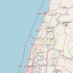
Map view of Jabal Moussa Biosphere Reserve

Use this park location map to pinpoint Jabal Moussa Biosphere Reserve in Lebanon, understand its exact geographic position, and read its mapped placement within the surrounding landscape more clearly.

Pigeon | © OpenStreetMap contributors

Location context for Jabal Moussa Biosphere Reserve

Keserwan District
Park atlas

Compare the regional spread of protected landscapes, mapping diverse mountain ecosystems and coastal biodiversity throughout the Eastern Mediterranean.

Discover Other National Parks and Protected Areas Near Jabal Moussa Biosphere Reserve
Browse other national parks and protected areas geographically relevant to Jabal Moussa Biosphere Reserve, covering the Mount Lebanon range and the broader Eastern Mediterranean region. Compare distinct conservation landscapes, archaeological sites, and varied terrain to deepen your atlas-style discovery of Lebanon's protected heritage.
Nature reserveNorth Lebanon Governorate

Tannourine Cedar Forest Nature Reserve: A Premier Protected Cedar Landscape in North Lebanon

Mapped geography of Lebanon's largest cedar forest.

Delve into the Tannourine Cedar Forest Nature Reserve, a protected area critically important for its extensive cedar groves within the North Lebanon Governorate. This nature reserve encompasses a complex mountain geography characterized by deep ravines, imposing cliffs, and secluded caves, providing a dramatic backdrop for its dominant cedar population. Users can explore the mapped boundaries and understand the regional landscape context of this ecologically significant coniferous forest, essential for Lebanon's natural atlas.

Area
1.955 km²
Established
1999
IUCN
IV
Relief
Mountain
Nature reserveLebanon

Horsh Ehden Nature Reserve: Protected Nature Reserve within Lebanon's Regional Geography

Explore mapped protected land and natural terrain.

Horsh Ehden Nature Reserve is identified as a critical protected area within Lebanon. This page facilitates an atlas-style exploration of the reserve's specific geographic footprint, highlighting its mapped boundaries and the distinct natural terrain it preserves. Understanding Horsh Ehden Nature Reserve's role as a nature reserve contributes to a broader appreciation of protected landscapes and their regional context.

Area
17.4 km²
Established
1992
IUCN
Ib
Relief
Mountain
Biosphere reserveLebanon

Aammiq Wetland Biosphere Reserve: Mapping Lebanon's Crucial Freshwater Protected Landscape

Discover its geography, mapped terrain, and role as a biodiversity hotspot.

Aammiq Wetland is Lebanon's most significant freshwater protected area, recognized as a UNESCO Biosphere Reserve and Ramsar site. Its unique geography, characterized by extensive reedbeds and open pools fed by mountain snowmelt, makes it a vital stopover for countless migratory bird species traversing the Middle East. This protected landscape offers rich opportunities for atlas-style exploration, revealing the ecological importance of its mapped terrain and its role as a critical biodiversity hotspot.

Area
2.53 km²
Established
1999
IUCN
IV
Relief
Lowland
Nature reserveLebanon

Al Shouf Cedar Nature Reserve: A Protected Landscape in Lebanon's Geography

Explore its mapped natural terrain and protected boundaries.

Investigate Al Shouf Cedar Nature Reserve, a protected natural area situated within Lebanon. This page offers a detailed view of its protected landscape identity and geographic context, crucial for understanding its placement within the region's natural atlas. Examine the mapped terrain and park boundaries that distinguish this significant nature reserve.

Area
550 km²
Established
1996
Relief
Mountain
Climate
Temperate
Nature reserve

Palm Islands Nature Reserve: A Protected Lebanese Nature Reserve with Critical Marine Habitats

Discover the island geography and mapped protected area.

Palm Islands Nature Reserve encompasses three flat, rocky limestone islands off the coast of northern Lebanon. This vital nature reserve, recognized internationally as a Ramsar site and Mediterranean Specially Protected Area, serves as a critical habitat for endangered green sea turtles and Mediterranean monk seals. Its unique coastal landscape and surrounding waters offer essential resting grounds for migratory birds, making it a significant point in the regional atlas of protected lands.

Area
4.2 km²
Established
1992
Relief
Lowland
Climate
Mediterranean
Nature reserveLebanon

Tyre Coast Nature Reserve: Lebanon's Protected Nature Reserve Geography and Atlas Mapping

Discover the mapped natural landscape and regional context.

Tyre Coast Nature Reserve represents a distinct protected area within Lebanon, offering a unique focus for geographic exploration. This entry provides detailed insights into its mapped boundaries, situating it within the broader natural landscape and regional geography of the country. Engage with the structured atlas data to understand the specific protected land identity and geographic characteristics of this nature reserve.

Area
3.8 km²
Established
1998
Relief
Lowland
Climate
Mediterranean
National parkIsrael

Bar'am National Park: Preserving Ancient Jewish Heritage and Galilee Landscape

Explore significant Talmudic-era synagogues and borderland geography.

Bar'am National Park is an important archaeological site in Israel's upper Galilee, renowned for its remarkably preserved ancient Jewish synagogues dating to the Talmudic period. These structures represent significant tangible evidence of Jewish religious life and architectural styles from late antiquity. Situated amidst the rolling hills of the Galilee countryside, the park's landscape offers a unique combination of historical reflection and scenic views towards the Lebanese border, making it a key destination for understanding regional heritage and geography.

Relief
Upland
Access
Moderate access
Scope
Terrestrial
Water
No major water
National parkIsrael

Yehi'am Fortress National Park: National Park with Protected Landscape Identity in Israel

Discover its mapped geographic boundaries and regional landscape context.

Yehi'am Fortress National Park is a key protected area situated within the geographic landscape of Israel. This national park entry provides structured insights into its distinct natural features and its role as a mapped protected zone. Explore the regional context and unique geographic identity of Yehi'am Fortress National Park, contributing to a broader understanding of Israel's conservation landscapes.

Relief
Upland
Access
Moderate access
Scope
Terrestrial
Water
No major water

Common questions about visiting, size, designation, and location context for Jabal Moussa Biosphere Reserve

Jabal Moussa Biosphere Reserve FAQs for park facts, access, geography, and protected area context
Find quick answers about Jabal Moussa Biosphere Reserve, including protected-area facts, park geography, trail and visitor context, and how the park fits into its surrounding country and regional landscape.
MoriAtlas Explorer

Continue Your Protected Areas Search Across the Global Atlas

Deepen your exploration by continuing the structured search for national parks and protected areas worldwide. Utilize the comprehensive filtering capabilities to compare different conservation landscapes and refine your understanding of global park geography. Discover more about the distribution and characteristics of protected natural areas.

Global natural geography