Mori Atlas logo
National parkKaratepe-Aslantaş National Park

Discover mapped boundaries and geographic context in Osmaniye Province, Turkey.

Karatepe-Aslantaş National Park: A National Park Blending Ancient Heritage and Mediterranean Landscapes

(Karatepe-Aslantaş Milli Parkı)

Karatepe-Aslantaş National Park, established in 1958, represents a significant protected area within Osmaniye Province. This unique national park combines rich Neo-Hittite archaeological sites, including Turkey's first open-air museum, with the distinctive Mediterranean ecosystems found between the Taurus Mountains foothills and the Çukurova plain. The park's terrain, ranging from 65 to 538 meters, features rugged hills and is defined by its prominent location on a peninsula within the Aslantaş Dam reservoir, offering a striking visual where ancient history meets natural geography.

archaeological siteMediterranean ecosystemNeo-Hittitenational parkopen-air museumreservoir
Stylized illustration of a lake surrounded by pine trees and mountains under a sunset sky

Karatepe-Aslantaş National Park

National park

Park overview

Structured park overview, official facts, and landscape profile for Karatepe-Aslantaş National Park

Karatepe-Aslantaş National Park park facts, protected area profile, and essential visitor context
Review the core facts for Karatepe-Aslantaş National Park, including designation, size, terrain, visitor scale, habitats, and operating context in one park-focused overview.

About Karatepe-Aslantaş National Park

Karatepe-Aslantaş National Park represents a rare combination of cultural preservation and natural conservation in Turkey's protected areas. The park's origins as a national park in 1958 were directly tied to the archaeological discoveries made at the site during excavations between 1946 and 1952, making it one of the earliest protected areas in the country to recognize both archaeological and natural values. The open-air museum at Karatepe remains the park's centerpiece, situated atop a peninsula within the Aslantaş Dam reservoir.

The archaeological site contains the ruins of an ancient fortified settlement from the Neo-Hittite period, dating to the 8th century BCE. Subsequent occupations during Roman and Byzantine periods left additional layers of history at the site. Visitors reach the open-air museum via a 1,200-meter stone-paved trail from the park entrance, ascending to what locals call the "Hittite Peninsula." The preserved artifacts, stone statues, and reliefs remain at their original locations within the ruined fortification walls, offering an authentic archaeological experience.

The park's location at the transition between the Taurus Mountains foothills and the Çukurova plains creates a diverse setting. The reservoir created by the Aslantaş Dam forms a prominent visual and ecological element, while the surrounding terrain supports Mediterranean vegetation communities. Several perennial streams feed into the reservoir along the park's boundaries, contributing to the ecological complexity of the area.

Quick facts and research context for Karatepe-Aslantaş National Park

Located 30 kilometers north of Osmaniye and 22 kilometers southeast of Kadirli, the park occupies a peninsula formed by the Aslantaş Dam reservoir. The protected area was Turkey's second national park and the first to incorporate an open-air museum at its core. Elevation ranges from 65 meters in the lower areas to 538 meters at Karatepe, the highest point. Several streams—Hillik Creek, Kırağı Creek, Kışla Creek, and Kaplan Creek—flow into the reservoir along the park's boundaries. The park supports 15 mammal species, 12 reptile species, 5 amphibian species, and 22 fish species, alongside Mediterranean flora including Turkish pine, oak, turpentine tree, and sumac.

Park context

Deeper park guide and search-rich context for Karatepe-Aslantaş National Park

Karatepe-Aslantaş National Park history, landscape, wildlife, and travel context
Explore Karatepe-Aslantaş National Park through its history, landscape character, ecosystems, wildlife, conservation priorities, cultural context, and seasonal travel timing in a structured park guide built for atlas discovery and search intent.

Why Karatepe-Aslantaş National Park stands out

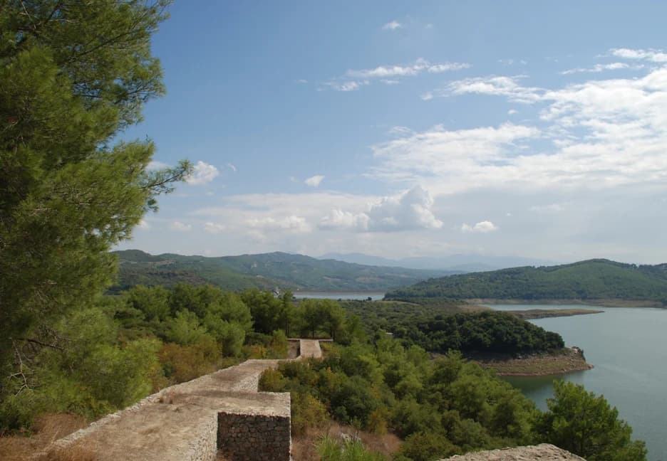
Karatepe-Aslantaş is best known for its extraordinary archaeological open-air museum, one of the most important Neo-Hittite sites in Anatolia. The site preserves the Karatepe Bilingual, a stone inscription featuring identical text in Phoenician alphabet and Hieroglyphic Luwian, which was instrumental in cracking the code of Anatolian hieroglyphs. The lion statues (Aslantaş) that give the site its name stand as iconic symbols of the ancient settlement. Beyond archaeology, the park is notable for its unique setting on a peninsula jutting into the Aslantaş Dam reservoir, where visitors can experience both cultural exploration and natural scenery in a single destination.

Karatepe Museum
Orthostat from Domuztepe, near Karatepe in Osmaniye, Southern Turkey, displayed in the local Karatepe museum. Two figures (gods?) dance around a tree of life under a sun disk. Likely from a workshop in Karatepe.

Karatepe-Aslantaş National Park history and protected-area timeline

Karatepe-Aslantaş National Park was established on May 29, 1958, making it the second national park in Turkey following the creation of the country's first protected area. The establishment was directly prompted by the significant archaeological discoveries made at the site during excavations carried out between 1946 and 1952. These excavations revealed the importance of the Neo-Hittite settlement and its exceptional collection of artifacts, including the Karatepe Bilingual inscriptions that would later prove crucial for scholarly understanding of Anatolian hieroglyphs.

The decision to designate the area as a national park rather than simply protecting the archaeological site reflected a broader vision to preserve both the cultural heritage and the natural landscape of the area. This approach was relatively innovative for the time in Turkey and set a precedent for subsequent protected areas that combined multiple conservation values. The open-air museum was developed as part of the national park designation, becoming Turkey's first open-air museum and establishing a model for archaeological preservation and presentation in the country.

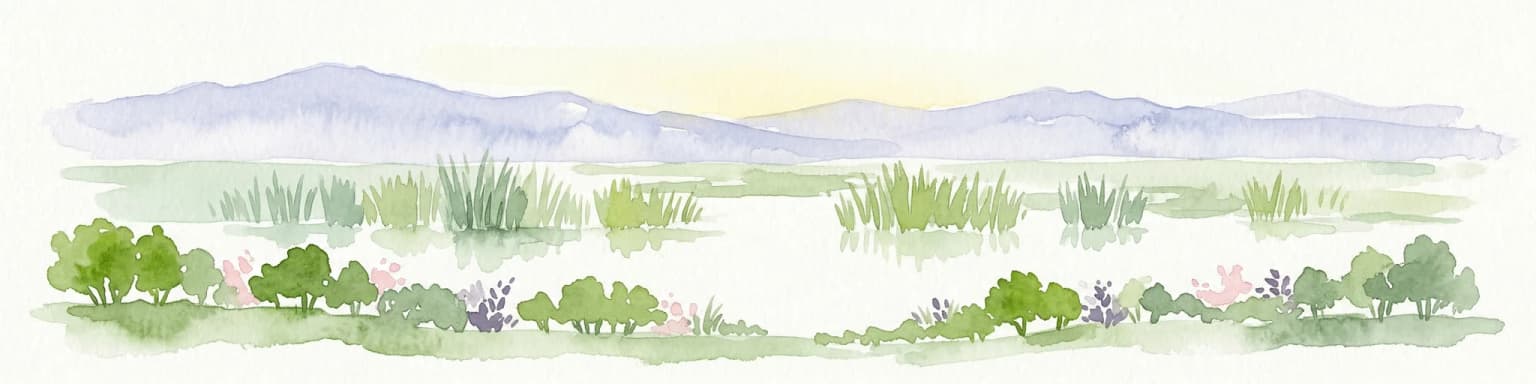
Karatepe-Aslantaş National Park landscape and geographic character

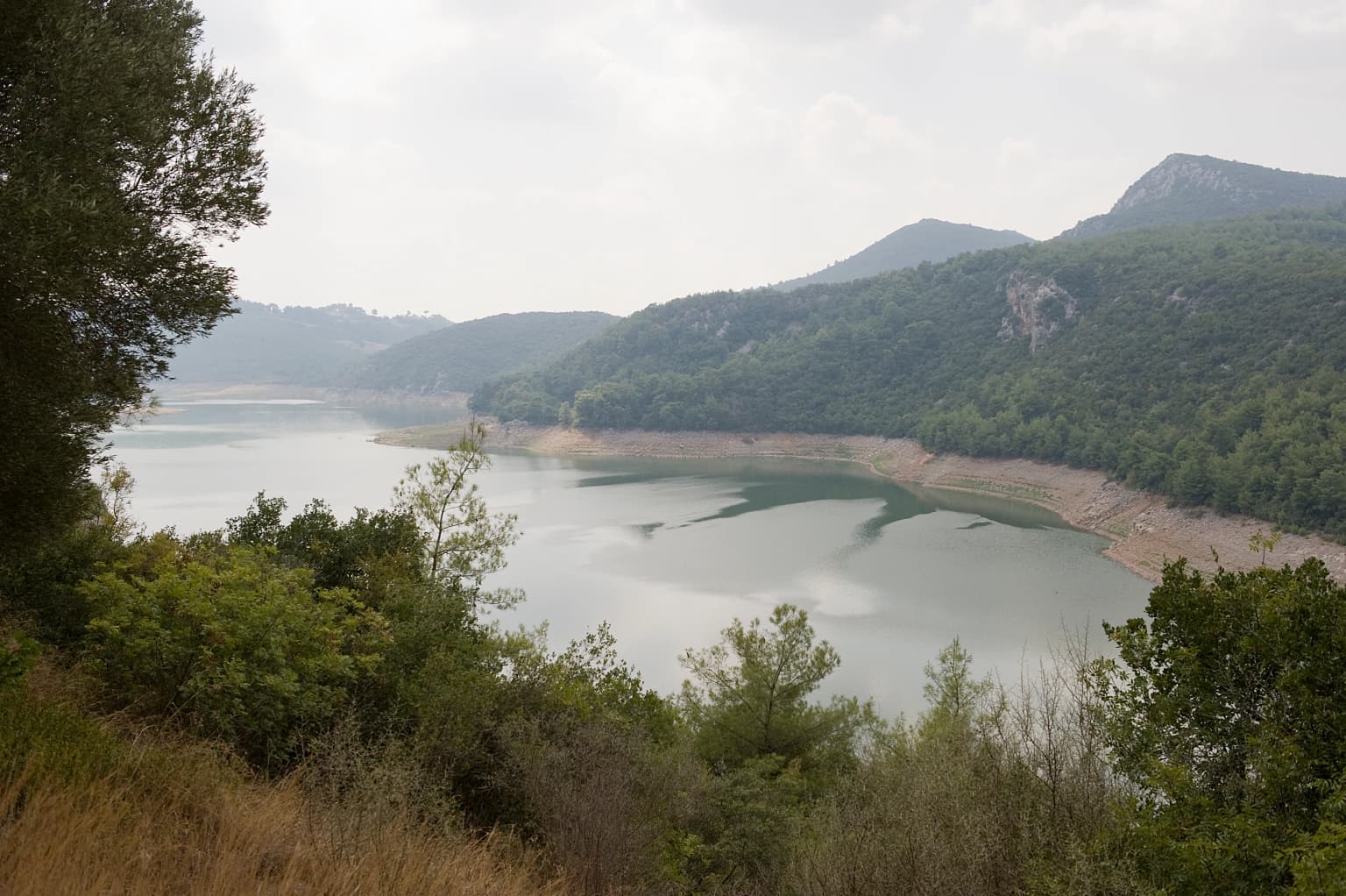
The landscape of Karatepe-Aslantaş National Park is defined by its position at the ecological and topographical transition between the Taurus Mountains foothills and the Çukurova plain. The terrain is slightly rugged, with elevation ranging from 65 meters in the lower areas to 538 meters at Karatepe, the highest point within the park. Several notable hills punctuate the terrain: İncirlitepe at 377 meters, Kalitepe at 345 meters, Karadağtepe at 492 meters, Garzedetepe at 479 meters, Gavurtaştepe at 401 meters, and Bocayücetepe at 338 meters.

The Aslantaş Dam reservoir forms a prominent landscape feature, with the archaeological site situated on a peninsula extending into the reservoir's waters. This aquatic element creates a distinctive visual setting where ancient stone walls rise from the shores of the artificial lake. The reservoir was created by damming the Ceyhan River, and several smaller streams—including Hillik Creek, Kırağı Creek, Kışla Creek, and Kaplan Creek—flow into the reservoir along the park's boundaries, all serving as tributaries of the Ceyhan River system.

Stone relief carving showing a standing figure holding a staff, a smaller figure, a bull, and a mythical creature on a stone slab
Stone relief carving at Karatepe's south gate depicting Hittite figures and a bull

Karatepe-Aslantaş National Park ecosystems, habitats, and plant life

The national park supports Mediterranean vegetation communities characteristic of southern Turkey's climate zone. Turkish pine (Pinus brutia) and various oak species (Quercus) form the primary woodland components, while oak shrub groves provide lower vegetation cover. The maquis formation—a distinctive Mediterranean shrubland—characterizes much of the park's natural vegetation, with turpentine tree (Pistacia terebinthus) and sumac (Rhus) among the typical species.

The park's location at the interface between mountain foothills and plain creates ecological diversity within a relatively limited area. The reservoir and its associated wetlands provide additional habitat variety, supporting aquatic and semi-aquatic species. The streams flowing into the reservoir contribute to habitat heterogeneity, while the various elevation zones allow for ecological gradients across the protected area. Picnic areas within the park have been planted with additional tree species including umbrella pine, walnut, plane tree, mulberry, melissa, and hydrangea, adding to the botanical diversity in developed areas.

Reservoir surrounded by hills and forested areas with dry grass in foreground
Scenic view of the Aslantaş Dam reservoir within Karatepe-Aslantaş National Park

Karatepe-Aslantaş National Park wildlife and species highlights

The wildlife community within Karatepe-Aslantaş National Park includes representatives from several taxonomic groups. Mammal species present in the park include wild boar, jackal, rabbit, fox, and squirrel, with 15 mammal species documented in total. The reptile fauna comprises 12 species, while 5 amphibian species have been recorded. Fish populations in the Aslantaş Dam reservoir and associated waters include catfish and carp species, with 22 fish species identified in the park.

The Mediterranean setting supports bird species typical of the region, though the English source does not provide detailed bird counts. The Turkish source specifically mentions pheasant (turaç) and partridge (keklik) among the notable bird species. The reservoir and stream environments provide aquatic habitat supporting fish communities, while the woodland and shrubland areas offer cover and foraging grounds for mammal and reptile species. The combination of terrestrial and aquatic habitats creates a reasonably diverse ecological community for a protected area of this size.

Karatepe-Aslantaş National Park conservation status and protection priorities

Karatepe-Aslantaş National Park holds significant conservation value both for its cultural heritage and its natural ecosystems. As the second national park established in Turkey, it represents an early example of protected-area designation in the country and helped establish the national park system. The inclusion of an open-air museum within the park boundary was innovative for its time and demonstrated a commitment to integrated cultural and natural conservation.

The park protects Mediterranean ecosystem types that represent the characteristic vegetation of southern Turkey's coastal and foothill zones. The woodland and maquis communities provide habitat for wildlife species and contribute to watershed protection in the Ceyhan River basin. The reservoir and its associated aquatic environments add another conservation dimension, supporting fish populations and wetland-dependent species. The archaeological site's preservation in situ maintains both the heritage value and the educational potential of the Neo-Hittite settlement.

Karatepe-Aslantaş National Park cultural meaning and human context

Karatepe-Aslantaş National Park preserves one of the most significant Neo-Hittite archaeological sites in Anatolia. The fortified settlement dates to the 8th century BCE and represents the cultural complexity of the late Iron Age in eastern Anatolia. The site's subsequent occupation during Roman and Byzantine periods added historical layers, creating a multi-period archaeological landscape.

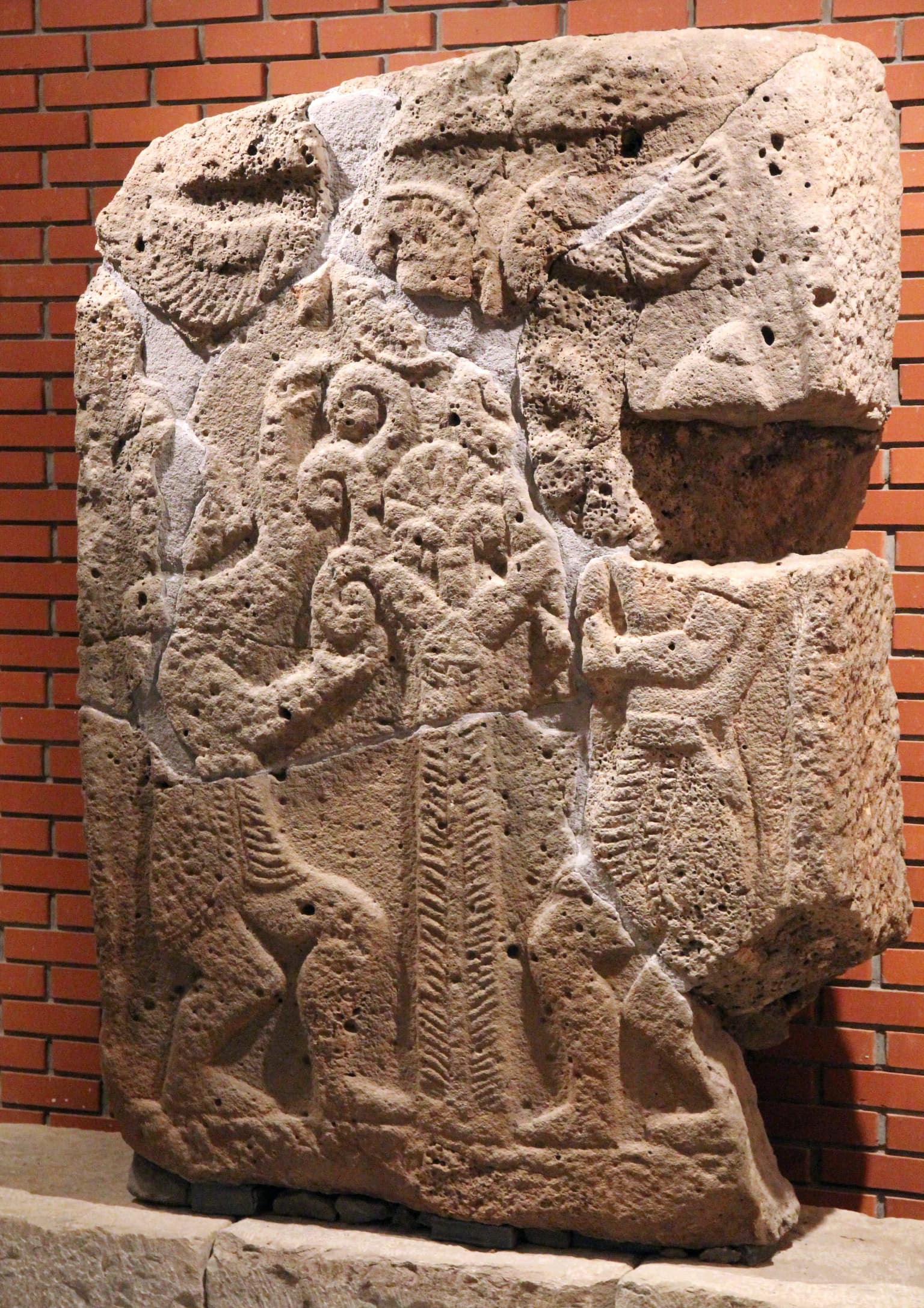
The Karatepe Bilingual inscriptions hold particular scholarly importance as they provided one of the key texts for deciphering Anatolian hieroglyphs—a writing system that had remained undeciphered for centuries. The inscription presents the same text in two scripts: Phoenician alphabet and Hieroglyphic Luwian, allowing scholars to use the known Phoenician text to decode the previously mysterious hieroglyphic script. This breakthrough had profound implications for understanding the history and languages of ancient Anatolia.

The lion statues known as Aslantaş (meaning "lion stone" or "lion rock") are among the most recognizable features of the site and provide its Turkish name. These stone sculptures guarded the ancient settlement and remain impressive examples of Neo-Hittite artistic achievement. The site is locally referred to as "Hitit Yarımadası" or "Hittite Peninsula," reflecting its historical association with the Hittite cultural sphere.

Top sights and standout views in Karatepe-Aslantaş National Park

The archaeological open-air museum at Karatepe remains the park's most distinctive feature—a Neo-Hittite walled settlement with preserved lion statues, fortification walls, and the famous bilingual inscription that enabled the decipherment of Anatolian hieroglyphs. The setting on a reservoir peninsula provides a unique visual backdrop where ancient stone structures meet modern dam infrastructure. The park offers hiking trails, picnicking areas, and camping at designated locations, allowing visitors to experience both cultural exploration and outdoor recreation. As Turkey's second national park and first open-air museum, Karatepe-Aslantaş represents an important chapter in the country's conservation history.

Best time to visit Karatepe-Aslantaş National Park

The park can be visited throughout the year, though the Mediterranean climate of southern Turkey makes spring and autumn particularly pleasant for outdoor exploration. Summers can be hot, while winters remain mild but may see increased precipitation. The open-air museum character of the site means it is best experienced during dry weather when walking the trail to the archaeological area is most comfortable. The reservoir setting provides scenic interest in all seasons, though the landscape's Mediterranean vegetation looks most vibrant in spring and early summer when flowering plants are in bloom.

Park location guide

Geography guide, regional context, and park location map for Karatepe-Aslantaş National Park

Karatepe-Aslantaş National Park park geography, regions, and map view in Turkey
Understand where Karatepe-Aslantaş National Park sits in Turkey through a broader geographic reading of the surrounding landscape, nearby location context, and its mapped position within the national park landscape.

How Karatepe-Aslantaş National Park fits into Turkey

Turkey, officially the Republic of Türkiye, is a transcontinental country located mainly in Anatolia (West Asia) with a smaller portion in East Thrace (Southeast Europe). It borders the Black Sea to the north, several countries to the east and south, and the Aegean Sea and European countries to the west. The country has a population of over 86 million and operates as a secular, Muslim-majority presidential republic with Ankara as capital and Istanbul as its largest city.

Wider geography shaping Karatepe-Aslantaş National Park in Turkey

Turkey is a transcontinental country with the majority of its territory (about 97%) located in Anatolia (West Asia) and a smaller portion called East Thrace in Southeast Europe. It borders the Black Sea to the north, Georgia, Armenia, Azerbaijan, and Iran to the east, Iraq and Syria to the south, and the Mediterranean Sea to the southwest. To the west, Turkey borders the Aegean Sea, Greece, and Bulgaria. The terrain includes mountains, plateaus, and coastal plains, with the Taurus Mountains running along the southern coast.

Map view of Karatepe-Aslantaş National Park

Use this park location map to pinpoint Karatepe-Aslantaş National Park in Turkey, understand its exact geographic position, and read its mapped placement within the surrounding landscape more clearly.

Pigeon | © OpenStreetMap contributors

Location context for Karatepe-Aslantaş National Park

Osmaniye Province

Visual Exploration of Neo-Hittite Protected Landscapes and Mediterranean Habitats within Turkey's Historic Park

Karatepe-Aslantaş National Park Photos: Explore Landscapes, Scenery, and Archaeological Sites
Visually explore Karatepe-Aslantaş National Park through this gallery, revealing its unique Neo-Hittite archaeological sites, characteristic Mediterranean terrain, and the scenic Aslantaş Dam reservoir. These images offer critical insight into the park's diverse habitats, protected natural environments, and the profound cultural significance defining this crucial Turkish conservation area.

Karatepe Museum

Stone city wall running along a hillside with a reservoir and mountains in the background

Stone relief carving showing a standing figure holding a staff, a smaller figure, a bull, and a mythical creature on a stone slab

Reservoir surrounded by hills and forested areas with dry grass in foreground

Park atlas

Broaden your geographic park discovery across Osmaniye Province and the Mediterranean ecosystems of southern Turkey.

Explore Other National Parks and Protected Areas Near Karatepe-Aslantaş National Park
Continue your exploration beyond Karatepe-Aslantaş National Park by discovering additional national parks and protected areas within its surrounding geography. Compare diverse conservation landscapes, map regional protected zones, and trace the spread of unique ecosystems throughout the Çukurova region.
National parkTurkey

Aladağlar National Park: Turkey's Dramatic Alpine Protected Landscape

Rugged terrain and crimson peaks in the Anti-Taurus Mountains.

Delve into Aladağlar National Park, a significant protected area defined by its striking alpine environment within Turkey's Anti-Taurus range. This park is renowned for its rugged, high-altitude wilderness, characterized by dramatic granite peaks that display a unique crimson coloration, especially at sunset. Its landscape features steep valleys, alpine lakes formed from snowmelt, and challenging mountaineering opportunities. MoriAtlas offers detailed map context to appreciate the geographic distinctiveness and ecological importance of this elevated protected terrain.

Area
550.65 km²
Established
1995
Relief
Mountain
Climate
Alpine
Watercolor illustration of a wetland landscape with distant mountains, grassy vegetation, and calm water.
National parkKayseri Province

Sultan Reedy National Park: A Vital Protected Wetland Ecosystem in Kayseri Province, Turkey

Mapped landscape focused on ornithological significance and lake ecosystems.

Sultan Reedy National Park stands as a cornerstone of wetland conservation in Turkey, located within the geographically distinct Kayseri Province. This national park is celebrated for its expansive freshwater lakes and dense reed marshes, forming a critical habitat for a vast diversity of bird species. Its Ramsar designation underscores its international importance as a stopover point for migratory birds traversing major flyways, offering a unique window into a dynamic aquatic ecosystem bordered by dramatic mountain terrain.

Area
243.57 km²
Established
2006
Relief
Lowland
Scope
Terrestrial
National parkTurkey

Göreme Historical National Park: A Mapped Volcanic Landscape and Protected Cultural Heritage in Turkey

Explore the unique geography and rock-cut churches of Cappadocia.

Göreme Historical National Park presents a globally significant protected landscape, celebrated for its dramatic volcanic geology and extensive rock-cut architecture. This national park in Turkey's Cappadocia region features iconic fairy chimneys and ancient cave dwellings, offering a rich context for exploring human adaptation to natural terrain. MoriAtlas facilitates a detailed discovery of its mapped boundaries and regional geography, highlighting the intersection of natural wonder and historical habitation within this unique protected area.

National parkŞanlıurfa

Tek Tek Mountains National Park: Protected Area with Ancient Ruins in Şanlıurfa, Turkey

Mapped geography and historical landscapes within Turkey's southeastern steppe.

Tek Tek Mountains National Park represents a vital protected area in Şanlıurfa Province, southeastern Turkey. This national park safeguards a unique landscape defined by the Tek Tek mountain range, featuring rugged terrain, rocky outcrops, and semi-arid steppe ecosystems. Beyond its natural beauty, the park is renowned for its significant archaeological heritage, including ancient settlements and religious sites that offer a glimpse into the region's historical depth. MoriAtlas provides a structured atlas view of this protected landscape, detailing its geographic features and its place within the regional context.

Area
193.35 km²
Established
2007
Relief
Mixed relief
Climate
Arid
National parkYozgat Province

Yozgat Pine Grove National Park: Historic First National Park and Ancient Pine Forest

Explore the protected landscape of Turkey's original national park.

As Turkey's pioneering national park, Yozgat Pine Grove National Park offers a deep dive into a unique protected landscape. This site provides detailed geographic context for its ancient pine forest, set dramatically against the steppe terrain of Yozgat Province. Understand the park's mapped boundaries and its ecological significance as a historic conservation area. MoriAtlas facilitates a structured exploration of this important natural heritage site, highlighting its role in Turkish protected land history and its distinct regional geography.

Area
2.64 km²
Established
1958
IUCN
II
Relief
Highland
National parkTunceli Province

Munzur Valley National Park: Tunceli Province's Vast Protected Alpine Landscape

Discover Turkey's largest national park and its unique mountain geography.

Munzur Valley National Park stands as a monumental protected area within Tunceli Province, Turkey. Its expansive territory encompasses approximately 420 square kilometers of dramatic mountain ranges, deep river valleys, and high-altitude glacial lakes. The park's complex geological makeup, shaped by tectonic forces and glacial activity, contributes to its unique terrain. This atlas entry highlights the park's role as a major biodiversity hotspot and a significant feature within eastern Anatolia's regional geography, offering rich context for landscape exploration.

Area
420 km²
Established
1971
IUCN
II
Watercolor painting of colorful rowboats on a lake with distant mountains
National parkKonya Province

Lake Beyşehir National Park: Protected Landscape Geography and Mapped Boundaries

Discover the geography and mapped context of this national park in Konya.

Lake Beyşehir National Park is a major protected area in Turkey's Central Anatolia region, celebrated for its immense freshwater lake and diverse wetland habitats. The park's identity is strongly tied to its mapped boundaries that protect critical ecosystems, islands, and surrounding forested terrain. This page provides a detailed look at the park's geographic setting within Konya Province, serving as a valuable resource for atlas-based discovery of its unique natural and cultural landscape.

Area
868.55 km²
Established
1993
Relief
Lowland
Climate
Temperate
National parkTurkey

Derebucak Çamlık Caves National Park: Turkey's Protected Karst Caves and Landscape

Explore Konya Province's longest cave system and its unique geological context.

Derebucak Çamlık Caves National Park is a vital protected landscape in central Turkey, celebrated for its extensive karst topography and significant cave formations. This national park encompasses thirteen unique caves and sinkholes, with Balatini Cave holding the distinction of being Konya Province's longest. The park's rugged terrain, characterized by pine forests and the Balat Stream feeding its underground systems, offers a profound look into Turkey's geological heritage and the conservation of its unique subterranean environments. MoriAtlas helps you navigate this mapped protected area.

Area
11.47 km²
Established
2022

Common questions about visiting, size, designation, and location context for Karatepe-Aslantaş National Park

Karatepe-Aslantaş National Park FAQs for park facts, access, geography, and protected area context
Find quick answers about Karatepe-Aslantaş National Park, including protected-area facts, park geography, trail and visitor context, and how the park fits into its surrounding country and regional landscape.
MoriAtlas Explorer

Continue Your Protected Areas Search Across the Global Atlas

Deepen your exploration by continuing the structured search for national parks and protected areas worldwide. Utilize the comprehensive filtering capabilities to compare different conservation landscapes and refine your understanding of global park geography. Discover more about the distribution and characteristics of protected natural areas.

Global natural geography